

Utah: Population, demographics and census data
Home to 3,538,904 people, the 30th largest of the 50 states and DC, anchored by Salt Lake City. It grew 18.1% between 2015 and 2025.
- Population
- 3.54M. Census Bureau estimate · Rank 30 of the 50 states and DC
- Median household income
- $99,311 ±$2,056. US $84,780
- Median age
- 32.6 ±0.2. US 39.5
ACS 2025 1-year estimates, U.S. Census Bureau
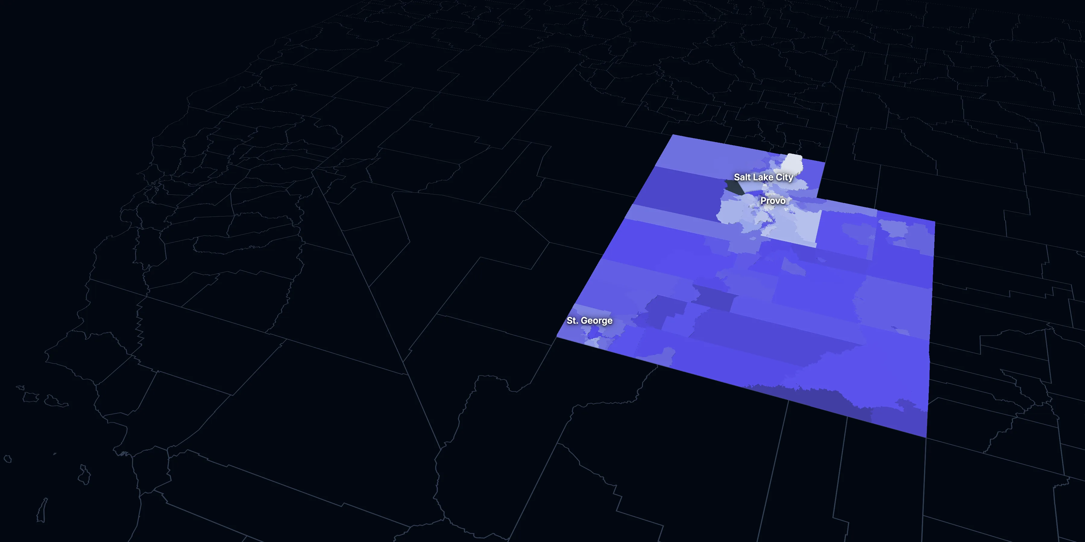
Taller, lighter tracts have higher household incomes
About Utah
Utah’s median household income is $99,311 (±$2,056), higher than the US ($84,780), and its median age is 32.6 (±0.2), according to the ACS 2025 1-year estimates. Its largest city is Salt Lake City.
± is each figure’s margin of error, at 90% confidence, and † marks one too uncertain to lean on. Under each percentage in the tables is the number it counts. How the margins are worked out.
FIPS code 49
Highlights
What stands out in Utah
The numbers where Utah sits furthest from the nation, or past a recognized policy benchmark.
Past a policy benchmark
+15 points
HighRent growth ahead of income
After inflation, rent grew 30% from 2015 to 2025, and household income 15%. The dots show rent growth.
Furthest from the national picture
32.6
Lowest among statesMedian age
That’s lower than the US (39.5). It’s the lowest of the 50 states and DC.
13.0%
Lowest among states65 and over
That’s lower than the US (19.0%). It’s the lowest of the 50 states and DC.
25.9%
Highest among statesUnder 18
That’s higher than the US (21.0%). It’s the highest of the 50 states and DC.
2.88
Highest among statesPeople per household
That’s higher than the US (2.49). It’s the highest of the 50 states and DC.
10.9%
Lowest among statesLiving with a disability
That’s lower than the US (13.7%). It’s the lowest of the 50 states and DC.
2015 to 2025
How Utah changed in ten years
The state added 542,985 people. It got older, more foreign-born and better educated, and poverty fell 2.6 points.
Population, change since 2015
+18.1% in the state and +6.3% in the US.
Source: ACS 1-year, 2015 to 2025, table A00001.
Show data
| Utah | United States | |
|---|---|---|
| 2015 | 0.0% | 0.0% |
| 2016 | +1.8% | +0.5% |
| 2017 | +3.5% | +1.3% |
| 2018 | +5.5% | +1.8% |
| 2019 | +7.0% | +2.1% |
| 2021 | +11.4% | +3.3% |
| 2022 | +12.8% | +3.7% |
| 2023 | +14.1% | +4.2% |
| 2024 | +16.9% | +5.8% |
| 2025 | +18.1% | +6.3% |
Embed
Median household income, in 2025 dollars
+15.2% in the state and +10.9% in the US.
Source: ACS 1-year, 2015 to 2025, table A14006.
Show data
| Utah | United States | |
|---|---|---|
| 2015 | $86,191 | $76,413 |
| 2016 | $89,239 | $77,931 |
| 2017 | $90,513 | $79,891 |
| 2018 | $92,309 | $80,059 |
| 2019 | $96,209 | $83,427 |
| 2021 | $95,180 | $83,521 |
| 2022 | $98,777 | $82,811 |
| 2023 | $99,388 | $82,683 |
| 2024 | $99,897 | $84,339 |
| 2025 | $99,311 | $84,780 |
Embed
Living in poverty
−2.6 points in the state and −3.0 points in the US.
Source: ACS 1-year, 2015 to 2025, table A13004.
Show data
| Utah | United States | |
|---|---|---|
| 2015 | 11.3% | 14.7% |
| 2016 | 10.2% | 14.0% |
| 2017 | 9.7% | 13.4% |
| 2018 | 9.0% | 13.1% |
| 2019 | 8.9% | 12.3% |
| 2021 | 8.6% | 12.8% |
| 2022 | 8.2% | 12.6% |
| 2023 | 9.0% | 12.5% |
| 2024 | 8.3% | 12.1% |
| 2025 | 8.6% | 11.8% |
Embed
Bachelor’s degree or more
+7.3 points in the state and +6.7 points in the US.
Source: ACS 1-year, 2015 to 2025, table A12001.
Show data
| Utah | United States | |
|---|---|---|
| 2015 | 31.8% | 30.6% |
| 2016 | 32.6% | 31.3% |
| 2017 | 34.6% | 32.0% |
| 2018 | 34.9% | 32.6% |
| 2019 | 34.8% | 33.1% |
| 2021 | 36.8% | 35.0% |
| 2022 | 37.9% | 35.7% |
| 2023 | 38.4% | 36.2% |
| 2024 | 39.1% | 36.8% |
| 2025 | 39.1% | 37.4% |
Embed
Median gross rent, in 2025 dollars
+29.9% in the state and +18.5% in the US.
Source: ACS 1-year, 2015 to 2025, table A18009.
Show data
| Utah | United States | |
|---|---|---|
| 2015 | $1,267 | $1,314 |
| 2016 | $1,290 | $1,327 |
| 2017 | $1,306 | $1,340 |
| 2018 | $1,348 | $1,368 |
| 2019 | $1,394 | $1,393 |
| 2021 | $1,447 | $1,427 |
| 2022 | $1,520 | $1,440 |
| 2023 | $1,650 | $1,496 |
| 2024 | $1,646 | $1,537 |
| 2025 | $1,646 | $1,557 |
Embed
Median home value, in 2025 dollars
+69.1% in the state and +39.3% in the US.
Source: ACS 1-year, 2015 to 2025, table A10036.
Show data
| Utah | United States | |
|---|---|---|
| 2015 | $321,407 | $266,469 |
| 2016 | $338,550 | $277,278 |
| 2017 | $364,260 | $288,124 |
| 2018 | $392,043 | $296,908 |
| 2019 | $419,345 | $305,336 |
| 2021 | $505,194 | $337,116 |
| 2022 | $553,328 | $355,481 |
| 2023 | $550,769 | $361,931 |
| 2024 | $563,472 | $372,685 |
| 2025 | $543,400 | $371,100 |
Embed
ACS 1-year estimates. The dotted stretch of each line spans 2020, when the Census Bureau released no standard 1-year estimates. Dollar values are in 2025 dollars.
| Indicator | 2015 | 2025 | Change |
|---|---|---|---|
| Population | 2,995,919 | 3,538,904 | +18.1% |
| Median age | 30.6 | 32.6 | +2.0 years |
| 65 and over | 10.3% | 13.0% | +2.7 points |
| Born outside the US | 8.2% | 9.8% | +1.6 points |
| Hispanic or Latino | 13.7% | 17.6% | +4.0 points |
| Median household income | $86,191 | $99,311 | +15.2% |
| Living in poverty | 11.3% | 8.6% | −2.6 points |
| Bachelor’s degree or more | 31.8% | 39.1% | +7.3 points |
| Households that rent | 31.1% | 31.3% | +0.2 points |
| Median gross rent | $1,267 | $1,646 | +29.9% |
| Median home value | $321,407 | $543,400 | +69.1% |
716 census tracts
Utah, tract by tract
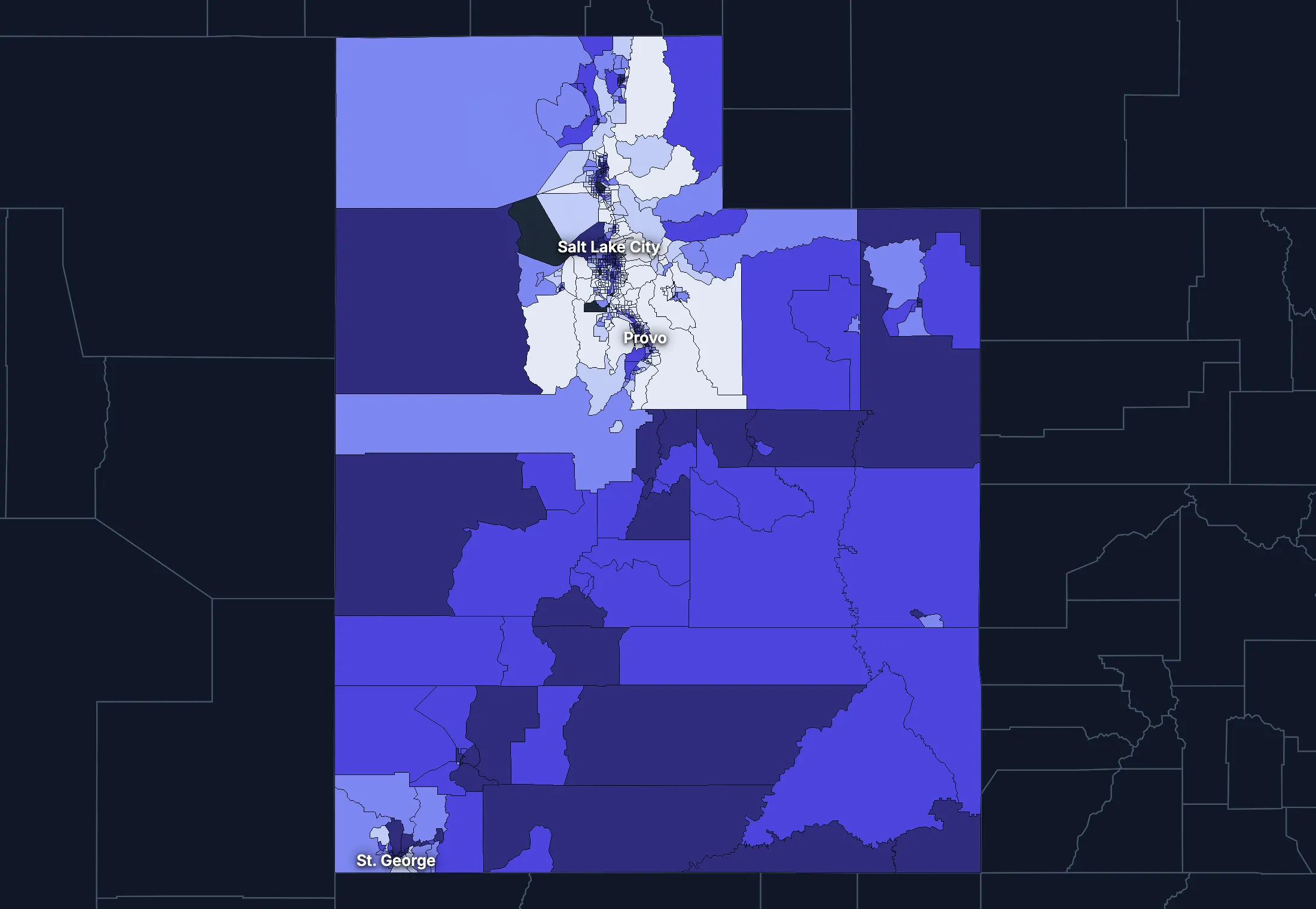
State averages hide a lot. These census tracts are the closest the census comes to neighborhoods.
Where the state’s average misleads
Each tick is one census tract, and the dark line marks the state. Hover over a tick or tap it to see the tract.
Poverty
142 of 708 tracts are at least 1.5 times the state’s overall 8.5%, and 154 are at two-thirds of it or less.
Highest: Tract 16.02, 74.6%. Lowest: Tract 9801, 0.0%.
Renters paying 30% or more of income
46 of 673 tracts are at least 1.5 times the state’s overall 44.8%, and 169 are at two-thirds of it or less.
Highest: Tract 1131.10, 100.0%. Lowest: Tract 9608.02, 0.0%.
Adults with a bachelor’s degree
97 of 710 tracts are at least 1.5 times the state’s overall 37.7%, and 173 are at two-thirds of it or less.
Highest: Tract 1148, 85.5%. Lowest: Tract 1128.18, 2.8%.
Median household income
68 of 708 tracts are at least 1.5 times the typical tract’s $96,942, and 98 are at two-thirds of it or less.
Highest: Tract 9801, $234,808. Lowest: Tract 1023, $27,446.
American Community Survey 2020–2024 5-year estimates, by census tract. Income is capped at $250,000+ by the Census Bureau.
People
Who lives in Utah
Its median age of 32.6 is lower than the US (39.5). 9.8% of residents were born outside the US, and 17.0% speak a language other than English at home.
Age
Source: ACS 2025 1-year, table A01001.
Show data
| Utah | United States | |
|---|---|---|
| Under 18 | 25.9% ±0.3% , number 918,324 ±9,998 | 21.0% ±<0.1% , number 71,689,151 ±111,800 |
| 18 to 24 | 12.2% ±0.3% , number 430,333 ±10,010 | 9.3% ±<0.1% , number 31,716,680 ±98,660 |
| 25 to 34 | 15.2% ±0.1% , number 539,264 ±4,375 | 13.6% ±<0.1% , number 46,357,354 ±55,690 |
| 35 to 44 | 13.4% ±0.3% , number 475,761 ±9,547 | 13.4% ±<0.1% , number 45,746,189 ±105,700 |
| 45 to 54 | 11.5% ±0.1% , number 405,337 ±4,097 | 11.8% ±<0.1% , number 40,257,563 ±53,540 |
| 55 to 64 | 8.8% ±0.2% , number 310,509 ±8,016 | 12.1% ±<0.1% , number 41,242,904 ±104,700 |
| 65 to 74 | 7.6% ±0.2% , number 270,068 ±7,000 | 10.8% ±<0.1% , number 36,895,650 ±91,520 |
| 75 and over | 5.3% ±0.2% , number 189,308 ±6,271 | 8.2% ±<0.1% , number 27,879,368 ±78,140 |
Embed
Race and ethnicity
Source: ACS 2025 1-year, table A04001.
Show data
| Utah | United States | |
|---|---|---|
| White, not Hispanic | 72.0% ±0.1% , number 2,546,313 ±5,026 | 55.0% ±<0.1% , number 187,959,031 ±58,340 |
| Hispanic or Latino | 17.6% , number 623,496 | 20.5% ±<0.1% , number 69,975,516 ±13,270 |
| Black, not Hispanic | 1.1% ±0.1% , number 37,303 ±3,642 | 11.7% ±<0.1% , number 40,096,453 ±106,200 |
| Asian, not Hispanic | 2.6% ±0.1% , number 93,068 ±4,775 | 6.5% ±<0.1% , number 22,096,709 ±58,340 |
| Other or multiracial | 6.7% ±0.3% , number 238,724 ±9,496 | 6.3% ±<0.1% , number 21,657,150 ±150,100 |
Embed
Language spoken at home
Source: ACS 2025 1-year, table C16001.
Show data
| Utah | United States | |
|---|---|---|
| English only | 83.0% ±0.5% , number 2,750,650 ±16,530 | 77.1% ±0.1% , number 249,390,588 ±275,300 |
| Spanish | 12.0% ±0.4% , number 396,119 ±14,830 | 13.9% ±0.1% , number 44,921,985 ±177,800 |
| Other Indo-European | 2.2% ±0.2% , number 73,386 ±7,466 | 4.0% ±<0.1% , number 12,862,980 ±113,500 |
| Asian and Pacific Island | 2.2% ±0.2% , number 74,162 ±8,039 | 3.8% ±<0.1% , number 12,288,841 ±99,740 |
| Arabic and other | 0.6% ±0.1% , number 18,936 ±3,716 | 1.3% ±<0.1% , number 4,116,949 ±71,480 |
Embed
Marital status
Source: ACS 2025 1-year, table A11001.
Show data
| Utah | United States | |
|---|---|---|
| Now married | 53.7% ±0.6% , number 1,499,865 ±16,390 | 47.9% ±0.1% , number 135,567,564 ±223,300 |
| Never married | 33.3% ±0.5% , number 929,622 ±14,750 | 34.8% ±0.1% , number 98,647,238 ±152,600 |
| Divorced | 8.3% ±0.3% , number 232,037 ±9,616 | 10.2% ±<0.1% , number 28,879,967 ±112,900 |
| Widowed | 3.6% ±0.2% , number 100,519 ±5,240 | 5.5% ±<0.1% , number 15,599,094 ±69,430 |
| Separated | 1.1% ±0.1% , number 30,415 ±3,870 | 1.6% ±<0.1% , number 4,441,399 ±49,160 |
Embed
Where people lived a year ago
Source: ACS 2025 1-year, table A08001.
Show data
| Utah | United States | |
|---|---|---|
| Same home | 86.4% ±0.6% , number 3,021,874 ±21,170 | 88.4% ±0.1% , number 298,889,697 ±214,800 |
| Same county | 7.6% ±0.5% , number 264,084 ±16,170 | 6.0% ±<0.1% , number 20,202,671 ±166,300 |
| Another county in the state | 2.8% ±0.2% , number 97,870 ±8,337 | 3.0% ±<0.1% , number 10,168,097 ±89,190 |
| Another state | 2.6% ±0.3% , number 91,316 ±8,801 | 2.1% ±<0.1% , number 7,025,589 ±81,660 |
| Another country | 0.6% ±0.1% , number 20,926 ±3,771 | 0.6% ±<0.1% , number 1,984,943 ±47,210 |
Embed
Top countries of birth, among those born abroad
Source: ACS 2020–2024 5-year, table A07001.
Show data
| Utah | |
|---|---|
| Mexico | 34.6% , number 104,833 |
| Venezuela | 4.3% , number 12,891 |
| Peru | 3.2% , number 9,668 |
| India | 2.9% , number 8,899 |
| El Salvador | 2.9% , number 8,638 |
| Colombia | 2.8% , number 8,445 |
Embed
All the numbers
| Indicator | Utah | US | Rank among states* | Table |
|---|---|---|---|---|
| Population | 3,538,904 | 341,784,859 | 30th | A00001 |
| People per square mile | 43 | 97 | 41st | A00002 |
| Land area (square miles) | 82,596 | – | – | A00002 |
| Median age | 32.6 ±0.2 | 39.5 ±0.1 | 51st | A01004 |
| Under 18 | 25.9% ±0.3% , number 918,324 ±9,998 | 21.0% ±<0.1% , number 71,689,151 ±111,800 | 1st | B02002 |
| 65 and over | 13.0% ±0.3% , number 459,376 ±9,398 | 19.0% ±<0.1% , number 64,775,018 ±120,300 | 51st | B02002 |
| Born outside the US | 9.8% ±0.4% , number 345,167 ±14,730 | 14.7% ±0.1% , number 50,409,320 ±204,800 | 23rd | A06001 |
| Speak a language other than English at home | 17.0% ±0.5% , number 562,603 ±18,810 | 22.9% ±0.1% , number 74,190,755 ±244,000 | 19th | C16001 |
| Veterans (adults) | 4.4% ±0.2% , number 116,210 ±4,381 | 5.9% ±<0.1% , number 15,746,228 ±85,320 | 46th | A16002 |
| Living with a disability | 10.9% ±0.3% , number 381,712 ±11,370 | 13.7% ±<0.1% , number 46,271,455 ±126,000 | 51st | B18101 |
| Women 15–50 who had a baby in the past year | 5.9% ±0.5% , number 54,294 ±4,736 | 5.0% ±0.1% , number 4,016,759 ±44,040 | 9th | B13002 |
| Lived in the same home a year ago | 86.4% ±0.6% , number 3,021,874 ±21,170 | 88.4% ±0.1% , number 298,889,697 ±214,800 | 38th | A08001 |
| White, not Hispanic | 72.0% ±0.1% , number 2,546,313 ±5,026 | 55.0% ±<0.1% , number 187,959,031 ±58,340 | 18th | A04001 |
| Hispanic or Latino | 17.6% , number 623,496 | 20.5% ±<0.1% , number 69,975,516 ±13,270 | 13th | A04001 |
| Black, not Hispanic | 1.1% ±0.1% , number 37,303 ±3,642 | 11.7% ±<0.1% , number 40,096,453 ±106,200 | 48th | A04001 |
| Asian, not Hispanic | 2.6% ±0.1% , number 93,068 ±4,775 | 6.5% ±<0.1% , number 22,096,709 ±58,340 | 33rd | A04001 |
*1 is the highest. Population is ranked among all states, and the rest among those of 1,000 people or more, whose figures can be ranked. Ranks use 5-year estimates, the only ones covering every state, so they can differ slightly from the figures here.
Income and work
Higher incomes than the US
The median household income is $99,311, higher than the US ($84,780). 8.6% of people live in poverty, and 8.6% have no health insurance, about the same as the US (8.4%).
Household income
Source: ACS 2025 1-year, table A14001.
Show data
| Utah | United States | |
|---|---|---|
| Under $25,000 | 10.1% ±0.6% , number 121,569 ±7,679 | 14.0% ±0.1% , number 18,727,548 ±88,990 |
| $25,000 to $49,999 | 12.4% ±0.6% , number 149,416 ±7,456 | 15.4% ±0.1% , number 20,665,585 ±101,400 |
| $50,000 to $74,999 | 14.7% ±0.6% , number 177,365 ±7,542 | 15.3% ±0.1% , number 20,513,565 ±88,500 |
| $75,000 to $99,999 | 13.1% ±0.6% , number 158,716 ±7,445 | 12.5% ±0.1% , number 16,814,245 ±87,520 |
| $100,000 to $149,999 | 21.7% ±0.9% , number 262,555 ±10,790 | 17.9% ±0.1% , number 24,018,984 ±99,670 |
| $150,000 to $199,999 | 11.9% ±0.5% , number 143,588 ±6,447 | 10.1% ±0.1% , number 13,521,827 ±70,660 |
| $200,000 or more | 16.1% ±0.6% , number 194,915 ±7,607 | 14.8% ±0.1% , number 19,801,668 ±84,120 |
Embed
What residents do for work
Source: ACS 2025 1-year, table A17004.
Show data
| Utah | United States | |
|---|---|---|
| Education and health care | 22.9% ±0.8% , number 415,969 ±14,000 | 24.4% ±0.1% , number 40,862,193 ±140,800 |
| Professional and business services | 13.1% ±0.6% , number 238,549 ±10,180 | 12.8% ±0.1% , number 21,375,231 ±87,110 |
| Retail trade | 10.7% ±0.5% , number 193,753 ±9,037 | 10.6% ±0.1% , number 17,781,181 ±96,660 |
| Manufacturing | 10.3% ±0.5% , number 186,776 ±9,283 | 9.6% ±0.1% , number 16,064,394 ±91,270 |
| Construction | 8.7% ±0.5% , number 157,988 ±9,398 | 6.7% ±<0.1% , number 11,254,981 ±79,620 |
| Arts, food and lodging | 8.4% ±0.4% , number 152,011 ±7,295 | 8.9% ±0.1% , number 14,811,502 ±87,840 |
| Finance, insurance and real estate | 7.3% ±0.4% , number 132,535 ±7,291 | 6.6% ±<0.1% , number 11,025,569 ±68,570 |
| Transportation and warehousing | 5.8% ±0.4% , number 105,095 ±7,320 | 5.9% ±<0.1% , number 9,832,211 ±73,020 |
Embed
Where workers come from and go
Utah has 1,667,200 jobs and 1,652,761 employed residents. 48,160 people commute in to work and 33,721 commute out, while 1,619,040 both live and work here. The most commuters come from Idaho.
Most commuters come from
- Idaho: 9,356
- California: 7,419
- Nevada: 6,733
Most residents commute to
- California: 5,204
- Idaho: 4,928
- Nevada: 4,861
Show data
| Utah | |
|---|---|
| Live and work here | 1,619,040 |
| Work here, live elsewhere | 48,160 |
| Live here, work elsewhere | 33,721 |
Embed
All the numbers
| Indicator | Utah | US | Rank among states* | Table |
|---|---|---|---|---|
| Median household income | $99,311 ±$2,056 | $84,780 ±$215 | 11th | A14006 |
| Income per person | $43,702 ±$666 | $47,171 ±$115 | 34th | A14024 |
| Income inequality (Gini index) | 0.435 ±0.007 | 0.482 ±0.001 | 51st | A14028 |
| Living in poverty | 8.6% ±0.6% , number 300,470 ±19,310 | 11.8% ±0.1% , number 39,264,183 ±277,400 | 50th | A13004 |
| Unemployment rate | 4.0% ±0.3% , number 75,850 ±5,489 | 4.9% ±<0.1% , number 8,574,594 ±64,350 | 45th | A17005 |
| No health insurance | 8.6% ±0.4% , number 303,614 ±14,200 | 8.4% ±<0.1% , number 28,323,306 ±152,000 | 21st | A20001 |
*1 is the highest. Population is ranked among all states, and the rest among those of 1,000 people or more, whose figures can be ranked. Ranks use 5-year estimates, the only ones covering every state, so they can differ slightly from the figures here.
Education
College degrees close to the US
39.1% of adults 25 and over have a bachelor’s degree or more, higher than the US (37.4%).
Highest level of education
Source: ACS 2025 1-year, table A12001.
Show data
| Utah | United States | |
|---|---|---|
| Less than high school | 6.5% ±0.4% , number 143,075 ±8,562 | 9.4% ±0.1% , number 22,321,002 ±120,500 |
| High school only | 21.8% ±0.6% , number 477,668 ±13,100 | 25.6% ±0.1% , number 61,096,726 ±203,400 |
| Some college | 32.5% ±0.7% , number 712,741 ±15,710 | 27.7% ±0.1% , number 65,920,977 ±173,500 |
| Bachelor’s degree | 24.7% ±0.6% , number 540,382 ±12,610 | 22.3% ±0.1% , number 53,224,312 ±196,700 |
| Graduate degree | 14.4% ±0.4% , number 316,381 ±9,791 | 15.0% ±0.1% , number 35,816,011 ±159,400 |
Embed
All the numbers
| Indicator | Utah | US | Rank among states* | Table |
|---|---|---|---|---|
| Bachelor’s degree or more | 39.1% ±0.7% , number 856,763 ±15,960 | 37.4% ±0.1% , number 89,040,323 ±253,200 | 15th | A12001 |
| High school graduate or more | 93.5% ±1.2% , number 2,047,172 ±25,950 | 90.6% ±0.2% , number 216,058,026 ±368,200 | 10th | A12001 |
*1 is the highest. Population is ranked among all states, and the rest among those of 1,000 people or more, whose figures can be ranked. Ranks use 5-year estimates, the only ones covering every state, so they can differ slightly from the figures here.
Housing
Home values outran incomes
31.3% of households rent, lower than the US (34.7%). The median home is worth $543,400 and the median rent is $1,646. After inflation, home values rose 69% from 2015 to 2025, while household income rose 15%.
Housing costs and income, 2015 to 2025, after inflation
Source: ACS 1-year, table A10036, A18009, A14006.
Show data
| Utah | United States | |
|---|---|---|
| Median home value | +69.1% | +39.3% |
| Median rent | +29.9% | +18.5% |
| Median household income | +15.2% | +10.9% |
Embed
Types of homes
Source: ACS 2025 1-year, table A10032.
Show data
| Utah | United States | |
|---|---|---|
| Single-family, detached | 64.2% ±0.7% , number 838,577 ±9,300 | 60.9% ±0.1% , number 90,335,844 ±173,300 |
| Single-family, attached | 9.1% ±0.5% , number 119,589 ±6,586 | 6.4% ±<0.1% , number 9,527,703 ±51,230 |
| 2 to 4 units | 6.1% ±0.4% , number 80,371 ±5,520 | 7.5% ±0.1% , number 11,109,005 ±75,790 |
| 5 to 19 units | 7.4% ±0.5% , number 96,723 ±6,441 | 8.7% ±0.1% , number 12,829,882 ±97,590 |
| 20 or more units | 9.9% ±0.6% , number 129,921 ±7,207 | 11.1% ±0.1% , number 16,381,450 ±92,310 |
| Mobile homes and other | 3.2% ±0.3% , number 41,849 ±4,122 | 5.4% ±<0.1% , number 8,045,083 ±53,680 |
Embed
When homes were built
Source: ACS 2025 1-year, table A10055.
Show data
| Utah | United States | |
|---|---|---|
| 2010 or later | 25.7% ±0.9% , number 310,809 ±10,730 | 15.1% ±0.1% , number 20,257,912 ±101,300 |
| 2000 to 2009 | 17.7% ±0.7% , number 213,556 ±8,234 | 13.8% ±0.1% , number 18,535,840 ±92,260 |
| 1980 to 1999 | 23.8% ±0.8% , number 287,644 ±9,318 | 24.1% ±0.1% , number 32,332,570 ±118,900 |
| 1960 to 1979 | 18.9% ±0.7% , number 228,260 ±8,248 | 22.9% ±0.1% , number 30,726,302 ±110,000 |
| Before 1960 | 13.9% ±0.6% , number 167,855 ±7,467 | 24.0% ±0.1% , number 32,210,798 ±121,500 |
Embed
All the numbers
| Indicator | Utah | US | Rank among states* | Table |
|---|---|---|---|---|
| Housing units | 1,307,030 | – | – | A10001 |
| Households | 1,208,124 ±6,720 | – | – | A10008 |
| People per household | 2.88 ±0.02 | 2.49 ±0.01 | 1st | A10003 |
| Households that rent | 31.3% ±0.9% , number 378,670 ±10,760 | 34.7% ±0.1% , number 46,551,688 ±193,200 | 39th | A10060 |
| Vacant homes | 7.6% ±0.5% , number 98,906 ±6,778 | 9.6% ±0.1% , number 14,165,545 ±137,100 | 43rd | A10047, A10060 |
| Median gross rent | $1,646 ±$22 | $1,557 ±$4 | 15th | A18009 |
| Median home value | $543,400 ±$4,242 | $371,100 ±$646 | 7th | A10036 |
| Renters paying 30% or more of income | 48.1% ±2.2% , number 182,050 ±9,959 | 48.3% ±0.2% , number 22,486,693 ±122,100 | 26th | A18002 |
| Owners paying 30% or more of income | 23.5% ±1.0% , number 194,533 ±8,633 | 24.2% ±0.1% , number 21,201,943 ±93,050 | 30th | A10040 |
| Homes built before 1960 | 13.9% ±0.6% , number 167,855 ±7,467 | 24.0% ±0.1% , number 32,210,798 ±121,500 | 39th | A10055 |
*1 is the highest. Population is ranked among all states, and the rest among those of 1,000 people or more, whose figures can be ranked. Ranks use 5-year estimates, the only ones covering every state, so they can differ slightly from the figures here.
Getting around
How people get around
68.7% of workers drive alone and 14.9% work from home. 30.7% of those who travel to work spend 30 minutes or more getting there, and 4.3% of households have no vehicle.
How people get to work
Source: ACS 2025 1-year, table A09005.
Show data
| Utah | United States | |
|---|---|---|
| Drive alone | 68.7% ±0.8% , number 1,233,657 ±16,590 | 69.8% ±0.1% , number 115,297,377 ±192,900 |
| Carpool | 10.2% ±0.6% , number 182,869 ±11,340 | 8.9% ±0.1% , number 14,712,170 ±97,240 |
| Public transit | 2.0% ±0.2% , number 35,493 ±4,401 | 4.3% ±<0.1% , number 7,100,386 ±63,330 |
| Walk | 2.4% ±0.3% , number 43,325 ±4,541 | 2.4% ±<0.1% , number 4,016,469 ±41,070 |
| Work from home | 14.9% ±0.5% , number 267,888 ±9,680 | 12.9% ±0.1% , number 21,288,393 ±105,700 |
| Other | 1.8% ±0.2% , number 31,476 ±3,660 | 1.7% ±<0.1% , number 2,799,658 ±41,510 |
Embed
Time spent getting to work
Source: ACS 2025 1-year, table B09001.
Show data
| Utah | United States | |
|---|---|---|
| Under 10 minutes | 14.4% ±0.5% , number 219,335 ±8,585 | 12.0% ±0.1% , number 17,199,225 ±93,440 |
| 10 to 19 minutes | 32.8% ±0.9% , number 500,843 ±14,010 | 27.8% ±0.1% , number 40,059,540 ±137,700 |
| 20 to 29 minutes | 22.1% ±0.7% , number 338,022 ±11,120 | 21.0% ±0.1% , number 30,221,743 ±111,100 |
| 30 to 39 minutes | 15.5% ±0.7% , number 237,223 ±11,100 | 17.1% ±0.1% , number 24,659,138 ±103,800 |
| 40 to 59 minutes | 9.1% ±0.5% , number 138,351 ±7,261 | 12.6% ±0.1% , number 18,104,709 ±97,070 |
| 60 minutes or more | 6.1% ±0.4% , number 93,046 ±6,625 | 9.5% ±0.1% , number 13,681,705 ±84,440 |
Embed
Vehicles per household
Source: ACS 2025 1-year, table A10030.
Show data
| Utah | United States | |
|---|---|---|
| None | 4.3% ±0.4% , number 51,459 ±4,568 | 8.8% ±0.1% , number 11,781,997 ±77,240 |
| One | 24.7% ±0.9% , number 298,635 ±10,610 | 33.1% ±0.1% , number 44,424,682 ±160,700 |
| Two | 38.5% ±1.0% , number 464,906 ±11,890 | 36.0% ±0.1% , number 48,200,889 ±176,800 |
| Three or more | 32.5% ±0.9% , number 393,124 ±10,950 | 22.1% ±0.1% , number 29,655,854 ±113,300 |
Embed
All the numbers
| Indicator | Utah | US | Rank among states* | Table |
|---|---|---|---|---|
| Drive to work alone | 68.7% ±0.8% , number 1,233,657 ±16,590 | 69.8% ±0.1% , number 115,297,377 ±192,900 | 38th | A09005 |
| Take public transit | 2.0% ±0.2% , number 35,493 ±4,401 | 4.3% ±<0.1% , number 7,100,386 ±63,330 | 19th | A09005 |
| Work from home | 14.9% ±0.5% , number 267,888 ±9,680 | 12.9% ±0.1% , number 21,288,393 ±105,700 | 10th | A09005 |
| Commute 30 minutes or more | 30.7% ±0.9% , number 468,620 ±14,830 | 39.2% ±0.1% , number 56,445,552 ±165,300 | 42nd | B09001 |
| Households with no vehicle | 4.3% ±0.4% , number 51,459 ±4,620 | 8.8% ±<0.1% , number 11,781,997 ±64,240 | 50th | A10030 |
*1 is the highest. Population is ranked among all states, and the rest among those of 1,000 people or more, whose figures can be ranked. Ranks use 5-year estimates, the only ones covering every state, so they can differ slightly from the figures here.
Places
The largest cities in Utah
Population, from the latest estimates available. Figures cover the whole of each place.
Largest cities
- Salt Lake City: 218,421
- West Valley City: 137,486
- West Jordan: 116,825
- Provo: 114,535
- St. George: 108,709
- Orem: 95,211
- Sandy: 92,383
- Ogden: 89,505
Every county and place in Utah
Find any county, city, town, metro area, ZIP code, school district or district in Utah.
Counties
Each of the 29 counties with its population, from ACS 2020–2024 5-year estimates.
- Beaver County7,273
- Box Elder County61,246
- Cache County140,046
- Carbon County20,517
- Daggett County783
- Davis County370,924
- Duchesne County20,185
- Emery County10,046
- Garfield County5,219
- Grand County9,754
- Iron County62,252
- Juab County12,586
- Kane County8,170
- Millard County13,315
- Morgan County12,802
- Piute County1,694
- Rich County2,631
- Salt Lake County1.20M
- San Juan County14,483
- Sanpete County29,719
- Sevier County22,085
- Summit County42,970
- Tooele County79,347
- Uintah County37,056
- Utah County705,400
- Wasatch County36,642
- Washington County196,431
- Wayne County2,584
- Weber County269,648
Cities, towns and other places
Each of the 326 with its population, from ACS 2020–2024 5-year estimates. Census-designated places are communities without a local government of their own, drawn by the Census Bureau so they can be counted.
- Alpine10,392
- Alta284
- Altamont435
- Alton260
- Amalga511
- American Fork37,109
- Aneth257
- Annabella701
- Antimony65
- Apple Valley1,181
- Aurora949
- Avon483
- Ballard1,803
- Bear River City867
- Beaver3,681
- Benjamin864
- Benson1,776
- Bicknell446
- Big Water502
- Blanding3,275
- Bluebell260
- Bluff233
- Bluffdale18,797
- Boulder360
- Bountiful45,023
- Brian Head74
- Brigham City19,992
- Brighton311
- Bryce Canyon City203
- Cache6
- Cannonville228
- Carbonville1,636
- Castle Dale1,546
- Castle Valley357
- Cedar City38,524
- Cedar Fort176
- Cedar Hills9,950
- Centerfield1,240
- Centerville16,679
- Central660
- Central Valley767
- Charleston414
- Circleville452
- Clarkston623
- Clawson197
- Clearfield33,523
- Cleveland378
- Clinton23,612
- Coalville1,881
- Copperton1,060
- Corinne783
- Cornish236
- Cottonwood Heights32,828
- Cove521
- Dammeron Valley877
- Daniel1,044
- Delta3,705
- Deseret270
- Deweyville415
- Draper50,278
- Duchesne1,753
- Dugway433
- Dutch John31
- Eagle Mountain53,290
- East Basin4,002
- East Carbon1,336
- Echo83
- Eden840
- Elberta170
- Elk Ridge4,898
- Elmo360
- Elsinore750
- Elwood1,547
- Emery491
- Emigration Canyon1,433
- Enoch8,144
- Enterprise CDP560
- Enterprise city1,955
- Ephraim5,949
- Erda3,881
- Escalante604
- Eureka828
- Fairfield198
- Fairview1,342
- Farmington25,389
- Farr West7,952
- Fayette471
- Ferron1,517
- Fielding746
- Fillmore2,676
- Flaming Gorge21
- Fort Duchesne271
- Fountain Green1,521
- Francis1,989
- Fremont90
- Fruit Heights6,023
- Garden24
- Garden City608
- Garland2,660
- Genola1,842
- Glendale493
- Glenwood673
- Goshen838
- Granite908
- Grantsville14,341
- Green River720
- Gunnison3,562
- Halchita254
- Hanksville215
- Harrisville6,935
- Hatch165
- Heber18,015
- Helper2,698
- Henefer1,005
- Henrieville391
- Herriman59,346
- Hideout1,253
- Highland20,119
- Hildale1,372
- Hinckley855
- Hobble Creek105
- Holden467
- Holladay31,099
- Honeyville1,275
- Hooper9,338
- Howell288
- Hoytsville800
- Huntington1,965
- Huntsville567
- Hurricane22,771
- Hyde Park5,540
- Hyrum10,401
- Independence79
- Interlaken156
- Ivins9,998
- Jensen258
- Joseph559
- Junction298
- Kamas2,096
- Kanab5,081
- Kanarraville257
- Kanosh465
- Kaysville33,053
- Kearns37,696
- Kenilworth127
- Kingston373
- Koosharem298
- La Sal373
- La Verkin4,476
- Lake Point2,563
- Lake Shore1,129
- Laketown437
- Lapoint122
- Layton83,286
- Leamington329
- Leeds646
- Lehi85,173
- Levan853
- Lewiston2,408
- Liberty1,484
- Lindon11,765
- Loa467
- Logan54,907
- Lyman289
- Lynndyl124
- Maeser4,435
- Magna30,031
- Manila371
- Manti3,594
- Mantua1,677
- Mapleton13,114
- Marion830
- Marriott-Slaterville1,979
- Marysvale484
- Mayfield384
- Meadow245
- Mendon1,482
- Mexican Hat20
- Midvale35,989
- Midway6,171
- Milford1,547
- Millcreek63,648
- Millville1,800
- Minersville873
- Moab5,312
- Mona1,674
- Monroe2,616
- Montezuma Creek239
- Monticello2,200
- Morgan4,409
- Moroni1,535
- Mount Pleasant3,805
- Mountain Green3,976
- Murray50,188
- Myton653
- Naples3,285
- Navajo Mountain610
- Neola354
- Nephi6,885
- New Harmony393
- Newcastle367
- Newton756
- Nibley7,952
- North Logan11,460
- North Ogden21,947
- North Salt Lake23,474
- Oak City854
- Oakley1,638
- Oasis66
- Ogden87,413
- Oljato-Monument Valley676
- Orangeville1,445
- Orderville803
- Orem97,182
- Palmyra301
- Panguitch1,701
- Paradise679
- Paragonah647
- Park City8,362
- Parowan3,165
- Payson23,039
- Peoa203
- Perry5,843
- Peter491
- Pine Valley355
- Plain City8,396
- Pleasant Grove37,852
- Pleasant View11,217
- Plymouth342
- Portage219
- Price8,248
- Providence8,947
- Provo114,766
- Randlett116
- Randolph722
- Redmond767
- Richfield8,224
- Richmond3,000
- River Heights2,282
- Riverdale9,279
- Riverside1,135
- Riverton45,457
- Rockville260
- Rocky Ridge1,060
- Roosevelt7,078
- Roy38,993
- Rush Valley458
- Salem10,324
- Salina2,546
- Salt Lake City208,007
- Samak29
- Sandy94,291
- Santa Clara8,152
- Santaquin16,436
- Saratoga Springs48,425
- Scipio466
- Scofield7
- Sigurd444
- Silver Summit1,476
- Smithfield14,408
- Snowville231
- Snyderville5,948
- South Jordan82,686
- South Ogden17,650
- South Salt Lake26,352
- South Weber8,115
- South Willard1,532
- Spanish Fork44,946
- Spanish Valley756
- Spring City1,057
- Spring Glen1,157
- Spring Lake657
- Springdale421
- Springville35,849
- St. George101,995
- Stansbury Park11,242
- Sterling281
- Stockton901
- Summit104
- Summit Park8,537
- Sundance104
- Sunset5,587
- Sutherland183
- Syracuse35,488
- Tabiona189
- Taylorsville58,678
- Teasdale308
- Thatcher1,170
- Timber Lakes683
- Tooele38,405
- Toquerville2,344
- Torrey323
- Tremonton11,477
- Trenton526
- Tropic582
- Tselakai Dezza104
- Uintah1,754
- Vernal10,392
- Vernon257
- Veyo355
- Vineyard14,446
- Virgin715
- Wales355
- Wallsburg305
- Wanship165
- Washington32,348
- Washington Terrace9,182
- Wellington1,624
- Wellsville4,157
- Wendover1,261
- West Bountiful5,915
- West Haven21,563
- West Jordan116,692
- West Mountain1,282
- West Point11,929
- West Valley City138,437
- West Wood962
- White City5,669
- White Mesa124
- Whiterocks117
- Willard2,212
- Wolf Creek1,339
- Woodland625
- Woodland Hills1,559
- Woodruff371
- Woods Cross11,531
Metro and micro areas
Each of the 11 that reach into Utah, with its whole population, from ACS 2020–2024 5-year estimates. Metro and micro areas are counties tied together by commuting, drawn by the Office of Management and Budget.
- Brigham City, UT-ID Micro Area66,014
- Cedar City, UT Micro Area62,252
- Evanston, WY-UT Micro Area23,275
- Heber, UT Micro Area79,612
- Logan, UT-ID Metro Area155,102
- Ogden, UT Metro Area653,374
- Price, UT Micro Area20,517
- Provo-Orem-Lehi, UT Metro Area717,986
- Salt Lake City-Murray, UT Metro Area1.28M
- St. George, UT Metro Area196,431
- Vernal, UT Micro Area37,056
ZIP codes
Each of the 289 with people in it, by the town it's centered in, from ACS 2020–2024 5-year estimates. These are the Census Bureau's ZIP Code Tabulation Areas, which follow the Postal Service's ZIP codes as closely as census blocks allow.
- 84001Altamont735
- 84002Altamont388
- 84003Alpine57,430
- 84004Alpine10,427
- 84005Eagle Mountain52,530
- 84006Copperton1,060
- 84007Bluebell431
- 84009South Jordan44,186
- 84010Bountiful46,871
- 84013Eagle Mountain558
- 84014Centerville16,679
- 84015West Point71,812
- 840174,417
- 84018182
- 84020Draper50,278
- 84021Duchesne3,069
- 84022516
- 8402371
- 84024Echo83
- 84025Farmington25,389
- 84026Fort Duchesne565
- 84027683
- 84028Garden City632
- 8402914,869
- 84031149
- 84032Independence26,111
- 84033Henefer1,109
- 84034144
- 84035Jensen568
- 840369,241
- 84037Kaysville39,415
- 84038Laketown646
- 84039Lapoint713
- 84040Layton28,509
- 84041Layton55,180
- 84042Lindon11,725
- 84043Lehi88,390
- 84044Magna30,031
- 84045Saratoga Springs45,429
- 84046Manila704
- 84047Midvale37,411
- 84049Midway6,833
- 84050Morgan12,620
- 84051Altamont377
- 84052Myton1,018
- 84053Neola588
- 84054North Salt Lake22,355
- 84055Samak1,584
- 84056Sunset3,803
- 84057Orem36,881
- 84058Orem35,099
- 84059Vineyard17,616
- 84060Park City8,619
- 84061Peoa422
- 84062Pleasant Grove47,813
- 84063Randlett322
- 84064Randolph846
- 84065Bluffdale50,768
- 84066Roosevelt15,154
- 84067Roy38,794
- 84069Rush Valley480
- 84070Sandy30,472
- 84071Stockton2,020
- 84072Tabiona539
- 84073Altamont208
- 84074Tooele59,706
- 84075Syracuse35,545
- 84076Lapoint460
- 84078Vernal30,975
- 84080Vernon438
- 84081West Jordan52,314
- 84082Wallsburg744
- 840831,261
- 84084West Jordan31,542
- 84085Whiterocks247
- 84086Woodruff507
- 84087West Bountiful16,808
- 84088West Jordan39,228
- 84092Granite27,651
- 84093Sandy23,871
- 84094White City27,507
- 84095South Jordan38,532
- 84096Herriman74,603
- 84097Orem22,217
- 84098Silver Summit20,357
- 84101Salt Lake City9,381
- 84102Salt Lake City18,777
- 84103Salt Lake City23,749
- 84104Salt Lake City23,420
- 84105Salt Lake City23,491
- 84106Salt Lake City35,213
- 84107Murray38,257
- 84108Emigration Canyon22,390
- 84109Emigration Canyon25,544
- 84111Salt Lake City12,782
- 84112Salt Lake City2,841
- 84113Salt Lake City264
- 84115South Salt Lake28,882
- 84116Woods Cross38,625
- 84117Holladay24,980
- 84118West Valley City42,853
- 84119West Valley City50,070
- 84120West Valley City50,799
- 84121Alta38,912
- 84123Taylorsville37,054
- 84124Millcreek22,609
- 84128West Valley City32,126
- 84129Taylorsville37,442
- 84150Salt Lake City6
- 84301Bear River City889
- 84302Honeyville27,053
- 84304Cache6
- 84305Clarkston667
- 84306Peter521
- 843071,356
- 84308Cornish260
- 84309Deweyville871
- 84310Wolf Creek4,577
- 84311Fielding1,013
- 84312Riverside4,857
- 84314Honeyville964
- 84315Hooper9,873
- 84316Howell288
- 84317Huntsville2,962
- 84318Hyde Park5,604
- 84319Avon10,931
- 84320Lewiston3,162
- 84321Hyde Park51,702
- 84324Mantua1,677
- 84325Peter2,525
- 84326Millville1,949
- 84327Newton921
- 84328Avon1,681
- 84329424
- 84330Plymouth364
- 84331Portage245
- 84332Providence8,954
- 84333Richmond3,093
- 84334Riverside180
- 84335Amalga16,210
- 84336481
- 84337Thatcher16,199
- 84338Trenton526
- 84339Wellsville6,295
- 84340Willard3,744
- 84341North Logan25,560
- 84401West Haven48,303
- 84403Ogden37,721
- 84404Plain City66,587
- 84405South Weber34,818
- 84408Ogden237
- 84414North Ogden34,334
- 84501Wellington13,042
- 84511White Mesa4,382
- 84512Tselakai Dezza860
- 84513Castle Dale1,546
- 84516Clawson197
- 84518Cleveland518
- 84520East Carbon826
- 84521Elmo629
- 84522Emery491
- 84523Ferron1,638
- 84525830
- 84526Helper4,388
- 84528Huntington2,752
- 84529Kenilworth127
- 84530La Sal402
- 84531Halchita518
- 84532Spanish Valley10,585
- 8453394
- 84534Montezuma Creek2,473
- 84535Monticello2,731
- 84536Oljato-Monument Valley1,387
- 84537Orangeville1,445
- 84539East Carbon510
- 845421,624
- 84601Provo32,330
- 84602Provo2,340
- 84604Sundance44,707
- 84606Provo35,690
- 84620Aurora1,234
- 84621Redmond124
- 84622Centerfield1,240
- 84623Wales358
- 84624Delta5,948
- 84626Elberta396
- 84627Ephraim6,244
- 84628Eureka871
- 846292,907
- 84630Fayette471
- 84631Fillmore3,196
- 84632Fountain Green1,522
- 84633Goshen838
- 84634Gunnison3,747
- 84635Sutherland938
- 84636Holden518
- 84637Kanosh598
- 84638Leamington354
- 84639Levan884
- 84640Lynndyl124
- 84642Manti3,501
- 84643Mayfield650
- 84644Meadow275
- 84645Mona3,316
- 84646Moroni1,882
- 84647Mount Pleasant4,770
- 84648Nephi7,385
- 84649Oak City854
- 84651Elk Ridge29,503
- 84652Redmond840
- 84653Salem13,051
- 846542,574
- 84655Santaquin18,278
- 84656Scipio466
- 84657Sigurd519
- 8466048,583
- 84662Spring City1,460
- 84663Hobble Creek36,207
- 84664Mapleton13,032
- 84665Sterling793
- 84667Wales355
- 84701Koosharem8,796
- 84710Alton298
- 84711Annabella805
- 84712Antimony96
- 84713Beaver4,330
- 84714779
- 84715Bicknell531
- 84716Boulder522
- 84718Cannonville233
- 84719Brian Head74
- 84720Kanarraville25,708
- 84721Enoch30,641
- 84722Central660
- 84723Circleville452
- 84724Elsinore1,202
- 84725Enterprise city2,054
- 84726Escalante772
- 8472844
- 84729Glendale493
- 84730Glenwood754
- 84731Beaver75
- 84732Koosharem21
- 84733Veyo276
- 84734Hanksville255
- 84735Hatch208
- 84736Escalante391
- 84737Apple Valley24,359
- 84738Ivins10,050
- 84739Joseph592
- 84740Junction298
- 847416,373
- 84742Kanarraville386
- 84743Kingston373
- 84744Koosharem321
- 84745La Verkin4,476
- 84746Leeds1,092
- 84747Fremont677
- 84749Bicknell304
- 84750Marysvale518
- 84751Milford1,896
- 84752Minersville972
- 84754Monroe4,298
- 84755Orderville78
- 84756Newcastle390
- 84757New Harmony1,494
- 84758Orderville725
- 84759Panguitch2,084
- 84760Paragonah1,054
- 84761Parowan3,044
- 84762132
- 84763Rockville260
- 84764362
- 847658,152
- 84766Joseph151
- 84767Springdale663
- 84770St. George48,397
- 84772Summit104
- 84773Teasdale357
- 84774Toquerville2,344
- 84775444
- 84776Tropic582
- 84779713
- 84780Washington32,366
- 84781Pine Valley355
- 84782Veyo598
- 84783Dammeron Valley928
- 84784Hildale1,372
- 84790St. George55,892
School districts
Each of the 41 with people in it, from ACS 2020–2024 5-year estimates.
- Alpine School District431,265
- Beaver School District7,273
- Box Elder School District61,246
- Cache School District85,523
- Canyons School District220,946
- Carbon School District20,517
- Daggett School District783
- Davis School District370,924
- Duchesne School District20,185
- Emery School District10,046
- Garfield School District5,219
- Grand School District10,505
- Granite School District403,911
- Iron School District62,252
- Jordan School District324,012
- Juab School District11,605
- Kane School District8,170
- Logan School District54,523
- Millard School District13,315
- Morgan School District12,802
- Murray School District39,647
- Nebo School District160,245
- North Sanpete School District12,895
- North Summit School District6,159
- Ogden School District87,395
- Park City School District27,307
- Piute School District1,694
- Provo School District113,890
- Rich School District2,631
- Salt Lake City School District208,007
- San Juan School District13,732
- Sevier School District22,085
- South Sanpete School District16,824
- South Summit School District9,504
- Tintic School District981
- Tooele School District79,347
- Uintah School District37,056
- Wasatch School District36,642
- Washington School District196,431
- Wayne School District2,584
- Weber School District182,253
Congressional districts
As drawn for the 119th Congress (2025–2027).
- Congressional District 1846,210
- Congressional District 2852,435
- Congressional District 3821,200
- Congressional District 4872,486
State senate districts
The upper chamber’s districts, as drawn in 2024.
- State Senate District 1119,937
- State Senate District 2116,310
- State Senate District 3115,565
- State Senate District 4118,024
- State Senate District 5113,946
- State Senate District 6117,018
- State Senate District 7115,690
- State Senate District 8111,232
- State Senate District 9117,703
- State Senate District 10116,152
- State Senate District 11127,987
- State Senate District 12112,298
- State Senate District 13107,796
- State Senate District 14112,836
- State Senate District 15110,811
- State Senate District 16112,119
- State Senate District 17120,274
- State Senate District 18120,938
- State Senate District 19108,194
- State Senate District 20117,119
- State Senate District 21117,433
- State Senate District 22134,723
- State Senate District 23115,270
- State Senate District 24113,073
- State Senate District 25119,109
- State Senate District 26113,505
- State Senate District 27126,164
- State Senate District 28122,252
- State Senate District 29118,853
State house districts
The lower chamber’s districts, as drawn in 2024.
- State House District 146,739
- State House District 246,369
- State House District 345,061
- State House District 445,779
- State House District 546,768
- State House District 644,055
- State House District 745,555
- State House District 841,532
- State House District 946,340
- State House District 1042,852
- State House District 1144,311
- State House District 1245,281
- State House District 1343,251
- State House District 1446,381
- State House District 1544,763
- State House District 1643,953
- State House District 1741,644
- State House District 1842,400
- State House District 1941,746
- State House District 2043,789
- State House District 2146,901
- State House District 2244,260
- State House District 2345,709
- State House District 2446,179
- State House District 2545,291
- State House District 2646,995
- State House District 2745,028
- State House District 2846,247
- State House District 2946,550
- State House District 3044,602
- State House District 3141,699
- State House District 3241,274
- State House District 3344,640
- State House District 3441,046
- State House District 3544,121
- State House District 3642,063
- State House District 3744,003
- State House District 3844,060
- State House District 3946,922
- State House District 4043,084
- State House District 4141,779
- State House District 4242,282
- State House District 4343,678
- State House District 4443,609
- State House District 4542,744
- State House District 4644,543
- State House District 4744,902
- State House District 4846,591
- State House District 4950,266
- State House District 5052,644
- State House District 5157,428
- State House District 5250,532
- State House District 5347,120
- State House District 5444,232
- State House District 5541,961
- State House District 5647,870
- State House District 5745,993
- State House District 5841,871
- State House District 5946,538
- State House District 6046,324
- State House District 6141,971
- State House District 6243,995
- State House District 6348,390
- State House District 6444,786
- State House District 6548,288
- State House District 6644,165
- State House District 6742,365
- State House District 6843,438
- State House District 6943,048
- State House District 7046,101
- State House District 7147,203
- State House District 7254,868
- State House District 7347,611
- State House District 7447,053
- State House District 7546,899
PUMAs
Public Use Microdata Areas: areas of 100,000 people or more that the state draws from census tracts, for the Census Bureau’s microdata.
- Cache, Summit, Morgan & Rich Counties PUMA198,449
- Davis County (Northeast)–Layton, Kaysville & South Weber Cities PUMA134,342
- Davis County (Northwest)–Syracuse, Clearfield & West Point Cities PUMA107,670
- Davis County (South)–Bountiful, Farmington & North Salt Lake Cities PUMA128,912
- Salt Lake County (East Central)–South Salt Lake, Murray, Holladay & Millcreek Cities PUMA167,357
- Salt Lake County (South & East Central)–Draper (Northwest) & Sandy (South) Cities PUMA110,613
- Salt Lake County (Southeast)–Sandy (North), Cottonwood Heights & Midvale Cities PUMA105,277
- Salt Lake County–Salt Lake City (East) & Emigration Canyon PUMA102,089
- Salt Lake County–Salt Lake City (West) & Magna PUMA107,454
- Salt Lake County–South Jordan, Herriman, Bluffdale & Riverton cities PUMA207,586
- Salt Lake County–Taylorsville, Kearns & Magna PUMA129,837
- Salt Lake County–West Jordan City PUMA133,140
- Salt Lake County–West Valley City PUMA133,170
- Southeast Utah & Uintah Basin Region PUMA149,466
- Southwest & South Central Utah (Outside Washington County)–Cedar City PUMA164,897
- Tooele & Box Elder Counties PUMA140,593
- Utah County (Central)–Orem, Pleasant Grove, American Fork & Lindon Cities PUMA195,126
- Utah County (Central)–Provo City PUMA114,902
- Utah County (East)–Spanish Fork, Springville, Lehi (Northeast) & Highland Cities PUMA190,162
- Utah County (West)–Saratoga Springs, Payson & Lehi (Southwest) Cities PUMA205,210
- Washington County–St. George City PUMA196,431
- Weber County (East)–Ogden (Southeast) & South Ogden Cities PUMA107,753
- Weber County (West)–Roy, North Ogden, Ogden (Northwest) & West Haven Cities PUMA161,895
Urban areas
Each that reaches into Utah, with its whole population. Urban areas are the densely settled land the Census Bureau draws after each census, whatever the city lines.
- Brigham City, UT26,838
- Cedar City, UT43,321
- Eagle Mountain, UT10,848
- Ephraim, UT5,169
- Grantsville, UT8,836
- Heber, UT25,936
- Hurricane, UT20,698
- Logan, UT118,943
- Moab, UT8,324
- Nephi, UT6,851
- Ogden–Layton, UT622,756
- Park City–Snyderville, UT15,137
- Payson–Santaquin, UT33,591
- Price, UT14,178
- Provo–Orem, UT617,373
- Richfield, UT8,618
- Roosevelt, UT6,849
- Salt Lake City, UT1.18M
- St. George, UT142,461
- Stansbury Park, UT13,052
- Summit Park, UT7,324
- Tooele, UT37,026
- Tremonton, UT13,736
- Vernal, UT21,755
- West Wendover, NV–UT5,380
Tribal areas
Each that reaches into Utah, with its whole population.
- Goshute Reservation, NV–UT148
- Navajo Nation Reservation and Off-Reservation Trust Land, AZ–NM–UT161,008
- Paiute (UT) Reservation, UT381
- Skull Valley Reservation, UT15
- Uintah and Ouray Reservation and Off-Reservation Trust Land, UT25,737
- Ute Mountain Reservation and Off-Reservation Trust Land, CO–NM–UT1,513
Turn Utah into your planning report.
Social Explorer Studio builds an editable profile of any place, with tables and charts beside the county and state, and exports to Word, PDF and Excel.
Questions about Utah
What is the population of Utah?
3,538,904 people, according to the ACS 2025 1-year estimates, which the Census Bureau adjusts to match its own population estimate. That’s the 30th largest of the 50 states and DC.
What is the FIPS code for Utah?
49. Every county’s and place’s FIPS code in Utah starts with it. The Census Bureau’s full geographic identifier (GEOID) is 0400000US49.
What is the largest city in Utah?
Salt Lake City, with 218,421 people. Other large cities here include West Valley City, West Jordan and Provo.
What is the median household income in Utah?
$99,311 (±$2,056), according to the ACS 2025 1-year estimates, higher than the US ($84,780).
What is the median age in Utah?
32.6 years (±0.2), according to the ACS 2025 1-year estimates, lower than the US (39.5).
How much does housing cost in Utah?
Utah’s median home value is $543,400 (±$4,242) and its median gross rent is $1,646 (±$22) a month, according to the ACS 2025 1-year estimates. 48.1% (±2.2%) of its renters pay 30% or more of their income on rent.
Is Utah growing?
Utah’s population grew 18.1%, from 2,995,919 in 2015 to 3,538,904 in 2025, according to the ACS 1-year estimates.
Where do people who work in Utah live?
1,619,040 of its 1,667,200 jobs are held by people who live here. Of those who commute in, the most come from Idaho, California, Nevada.
Where does this census data come from?
The U.S. Census Bureau’s American Community Survey, through Social Explorer’s tables: the latest 1-year estimates where they exist, for the most recent numbers, and 5-year estimates otherwise. Each table lists its code, so you can find it again.
Is this data free to use?
Yes. You can read it, cite it, download the CSV and embed the charts, with no account. To map other variables, compare your own areas or build a report, see Social Explorer’s plans in a live demo.
Sources and how to cite
American Community Survey 2025 1-year estimates, or 2020–2024 5-year estimates where noted, U.S. Census Bureau, from Social Explorer’s tables A00001, A00002, A01004, A04001, A06001, A08001, A09005, A10001, A10003, A10008, A10030, A10036, A10040, A10047, A10055, A10060, A12001, A13004, A14006, A14024, A14028, A16002, A17005, A18002, A18009, A20001, B02002, B09001, B13002, B18101, C16001. Maps by census tract use 2020–2024 5-year estimates, since the 1-year survey doesn’t cover tracts. Commuting: LEHD LODES 2023. These are estimates from a sample, each with its margin of error. Data retrieved November 14, 2026. How these profiles are made.
U.S. Census Bureau, American Community Survey 2025 1-year estimates, or 2020–2024 5-year estimates where noted, via Social Explorer. “Utah.” https://www.socialexplorer.com/places/utah. Accessed November 14, 2026.