

Kentucky: Population, demographics and census data
Home to 4,606,864 people, the 26th largest of the 50 states and DC, anchored by Louisville/Jefferson County and Lexington-Fayette. It grew 4.1% between 2015 and 2025.
- Population
- 4.61M. Census Bureau estimate · Rank 26 of the 50 states and DC
- Median household income
- $66,447 ±$962. US $84,780
- Median age
- 39.8 ±0.2. US 39.5
ACS 2025 1-year estimates, U.S. Census Bureau
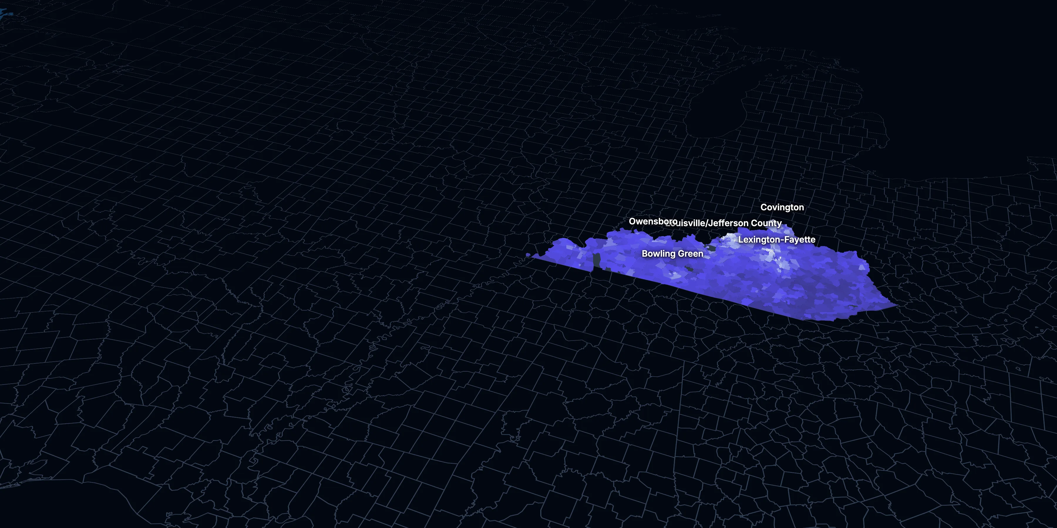
Taller, lighter tracts have higher household incomes
About Kentucky
Kentucky’s median household income is $66,447 (±$962), lower than the US ($84,780), and its median age is 39.8 (±0.2), according to the ACS 2025 1-year estimates. Its largest community is Louisville/Jefferson County.
± is each figure’s margin of error, at 90% confidence, and † marks one too uncertain to lean on. Under each percentage in the tables is the number it counts. How the margins are worked out.
FIPS code 21
Highlights
What stands out in Kentucky
The numbers where Kentucky sits furthest from the nation, or past a recognized policy benchmark.
Past a policy benchmark
15.9%
ElevatedLiving in poverty
That’s higher than the US (11.8%). HUD and the New Markets Tax Credit use 20% poverty to mark low-income areas. It’s the 5th highest of the 50 states and DC.
+4 points
ElevatedRent growth ahead of income
After inflation, rent grew 11% from 2015 to 2025, and household income 7%. The dots show rent growth.
Furthest from the national picture
18.1%
3rd among statesLiving with a disability
That’s higher than the US (13.7%). It’s the 3rd highest of the 50 states and DC.
7.6%
Very lowSpeak a language other than English at home
That’s lower than the US (22.9%).
$1,072
Lower than the USMedian gross rent
That’s lower than the US ($1,557). It’s the 6th lowest of the 50 states and DC.
5.7%
Very lowBorn outside the US
That’s lower than the US (14.7%).
2015 to 2025
How Kentucky changed in ten years
The state added 181,772 people. It got older, more foreign-born and better educated, and poverty fell 2.6 points.
Population, change since 2015
+4.1% in the state and +6.3% in the US.
Source: ACS 1-year, 2015 to 2025, table A00001.
Show data
| Kentucky | United States | |
|---|---|---|
| 2015 | 0.0% | 0.0% |
| 2016 | +0.3% | +0.5% |
| 2017 | +0.7% | +1.3% |
| 2018 | +1.0% | +1.8% |
| 2019 | +1.0% | +2.1% |
| 2021 | +1.9% | +3.3% |
| 2022 | +2.0% | +3.7% |
| 2023 | +2.3% | +4.2% |
| 2024 | +3.7% | +5.8% |
| 2025 | +4.1% | +6.3% |
Embed
Median household income, in 2025 dollars
+7.3% in the state and +10.9% in the US.
Source: ACS 1-year, 2015 to 2025, table A14006.
Show data
| Kentucky | United States | |
|---|---|---|
| 2015 | $61,945 | $76,413 |
| 2016 | $63,110 | $77,931 |
| 2017 | $64,053 | $79,891 |
| 2018 | $64,949 | $80,059 |
| 2019 | $66,393 | $83,427 |
| 2021 | $66,576 | $83,521 |
| 2022 | $65,736 | $82,811 |
| 2023 | $65,022 | $82,683 |
| 2024 | $66,688 | $84,339 |
| 2025 | $66,447 | $84,780 |
Embed
Living in poverty
−2.6 points in the state and −3.0 points in the US.
Source: ACS 1-year, 2015 to 2025, table A13004.
Show data
| Kentucky | United States | |
|---|---|---|
| 2015 | 18.5% | 14.7% |
| 2016 | 18.5% | 14.0% |
| 2017 | 17.2% | 13.4% |
| 2018 | 16.9% | 13.1% |
| 2019 | 16.3% | 12.3% |
| 2021 | 16.5% | 12.8% |
| 2022 | 16.5% | 12.6% |
| 2023 | 16.4% | 12.5% |
| 2024 | 15.6% | 12.1% |
| 2025 | 15.9% | 11.8% |
Embed
Bachelor’s degree or more
+5.4 points in the state and +6.7 points in the US.
Source: ACS 1-year, 2015 to 2025, table A12001.
Show data
| Kentucky | United States | |
|---|---|---|
| 2015 | 23.3% | 30.6% |
| 2016 | 23.4% | 31.3% |
| 2017 | 24.0% | 32.0% |
| 2018 | 24.8% | 32.6% |
| 2019 | 25.1% | 33.1% |
| 2021 | 27.0% | 35.0% |
| 2022 | 27.9% | 35.7% |
| 2023 | 27.8% | 36.2% |
| 2024 | 27.9% | 36.8% |
| 2025 | 28.7% | 37.4% |
Embed
Median gross rent, in 2025 dollars
+11.4% in the state and +18.5% in the US.
Source: ACS 1-year, 2015 to 2025, table A18009.
Show data
| Kentucky | United States | |
|---|---|---|
| 2015 | $962 | $1,314 |
| 2016 | $956 | $1,327 |
| 2017 | $959 | $1,340 |
| 2018 | $1,007 | $1,368 |
| 2019 | $981 | $1,393 |
| 2021 | $994 | $1,427 |
| 2022 | $987 | $1,440 |
| 2023 | $988 | $1,496 |
| 2024 | $1,031 | $1,537 |
| 2025 | $1,072 | $1,557 |
Embed
Median home value, in 2025 dollars
+35.9% in the state and +39.3% in the US.
Source: ACS 1-year, 2015 to 2025, table A10036.
Show data
| Kentucky | United States | |
|---|---|---|
| 2015 | $178,103 | $266,469 |
| 2016 | $183,409 | $277,278 |
| 2017 | $186,698 | $288,124 |
| 2018 | $191,433 | $296,908 |
| 2019 | $192,597 | $305,336 |
| 2021 | $207,613 | $337,116 |
| 2022 | $217,454 | $355,481 |
| 2023 | $225,329 | $361,931 |
| 2024 | $233,574 | $372,685 |
| 2025 | $242,000 | $371,100 |
Embed
ACS 1-year estimates. The dotted stretch of each line spans 2020, when the Census Bureau released no standard 1-year estimates. Dollar values are in 2025 dollars.
| Indicator | 2015 | 2025 | Change |
|---|---|---|---|
| Population | 4,425,092 | 4,606,864 | +4.1% |
| Median age | 38.8 | 39.8 | +1.0 years |
| 65 and over | 15.2% | 18.9% | +3.7 points |
| Born outside the US | 3.6% | 5.7% | +2.2 points |
| Hispanic or Latino | 3.3% | 5.8% | +2.5 points |
| Median household income | $61,945 | $66,447 | +7.3% |
| Living in poverty | 18.5% | 15.9% | −2.6 points |
| Bachelor’s degree or more | 23.3% | 28.7% | +5.4 points |
| Households that rent | 33.7% | 31.8% | −1.9 points |
| Median gross rent | $962 | $1,072 | +11.4% |
| Median home value | $178,103 | $242,000 | +35.9% |
1306 census tracts
Kentucky, tract by tract
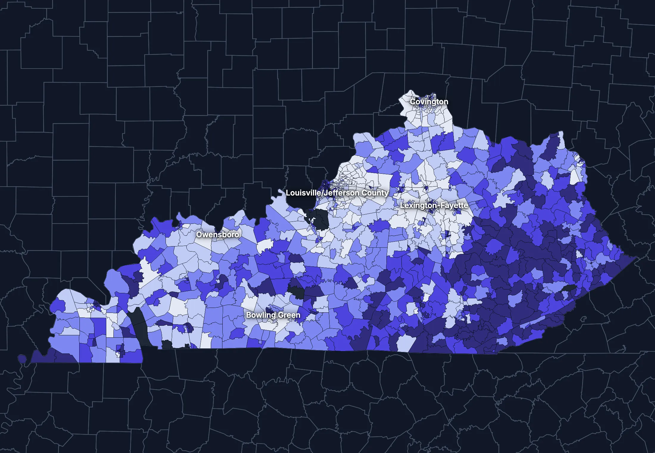
State averages hide a lot. These census tracts are the closest the census comes to neighborhoods.
Where the state’s average misleads
Each tick is one census tract, and the dark line marks the state. Hover over a tick or tap it to see the tract.
Poverty
320 of 1296 tracts are at least 1.5 times the state’s overall 16.1%, and 415 are at two-thirds of it or less.
Highest: Tract 8.01, 95.7%. Lowest: Tract 115.18, 0.2%.
Renters paying 30% or more of income
101 of 1255 tracts are at least 1.5 times the state’s overall 40.5%, and 341 are at two-thirds of it or less.
Highest: Tract 124.13, 95.8%. Lowest: Tract 706.01, 0.0%.
Adults with a bachelor’s degree
217 of 1297 tracts are at least 1.5 times the state’s overall 27.6%, and 541 are at two-thirds of it or less.
Highest: Tract 8.02, 83.4%. Lowest: Tract 9709, 0.8%.
Median household income
191 of 1291 tracts are at least 1.5 times the typical tract’s $60,240, and 204 are at two-thirds of it or less.
Highest: Tract 23.04, $248,571. Lowest: Tract 35.02, $9,038.
American Community Survey 2020–2024 5-year estimates, by census tract. Income is capped at $250,000+ by the Census Bureau.
People
Who lives in Kentucky
Its median age of 39.8 is higher than the US (39.5). 5.7% of residents were born outside the US, and 7.6% speak a language other than English at home.
Age
Source: ACS 2025 1-year, table A01001.
Show data
| Kentucky | United States | |
|---|---|---|
| Under 18 | 21.9% ±0.3% , number 1,010,804 ±12,420 | 21.0% ±<0.1% , number 71,689,151 ±111,800 |
| 18 to 24 | 9.2% ±0.2% , number 425,646 ±11,020 | 9.3% ±<0.1% , number 31,716,680 ±98,660 |
| 25 to 34 | 12.6% ±0.1% , number 581,901 ±6,607 | 13.6% ±<0.1% , number 46,357,354 ±55,690 |
| 35 to 44 | 13.0% ±0.3% , number 597,047 ±12,250 | 13.4% ±<0.1% , number 45,746,189 ±105,700 |
| 45 to 54 | 11.9% ±0.1% , number 549,266 ±6,578 | 11.8% ±<0.1% , number 40,257,563 ±53,540 |
| 55 to 64 | 12.4% ±0.2% , number 570,916 ±10,420 | 12.1% ±<0.1% , number 41,242,904 ±104,700 |
| 65 to 74 | 11.1% ±0.2% , number 509,615 ±9,453 | 10.8% ±<0.1% , number 36,895,650 ±91,520 |
| 75 and over | 7.9% ±0.2% , number 361,669 ±8,365 | 8.2% ±<0.1% , number 27,879,368 ±78,140 |
Embed
Race and ethnicity
Source: ACS 2025 1-year, table A04001.
Show data
| Kentucky | United States | |
|---|---|---|
| White, not Hispanic | 78.7% ±0.1% , number 3,627,521 ±6,124 | 55.0% ±<0.1% , number 187,959,031 ±58,340 |
| Hispanic or Latino | 5.8% ±0.1% , number 269,047 ±3,845 | 20.5% ±<0.1% , number 69,975,516 ±13,270 |
| Black, not Hispanic | 7.7% ±0.2% , number 354,571 ±9,958 | 11.7% ±<0.1% , number 40,096,453 ±106,200 |
| Asian, not Hispanic | 2.0% ±0.1% , number 91,371 ±3,252 | 6.5% ±<0.1% , number 22,096,709 ±58,340 |
| Other or multiracial | 5.7% ±0.3% , number 264,354 ±14,130 | 6.3% ±<0.1% , number 21,657,150 ±150,100 |
Embed
Language spoken at home
Source: ACS 2025 1-year, table C16001.
Show data
| Kentucky | United States | |
|---|---|---|
| English only | 92.4% ±0.4% , number 4,022,877 ±15,850 | 77.1% ±0.1% , number 249,390,588 ±275,300 |
| Spanish | 3.8% ±0.2% , number 167,011 ±9,301 | 13.9% ±0.1% , number 44,921,985 ±177,800 |
| Other Indo-European | 1.6% ±0.2% , number 69,278 ±7,824 | 4.0% ±<0.1% , number 12,862,980 ±113,500 |
| Asian and Pacific Island | 1.2% ±0.1% , number 52,646 ±6,212 | 3.8% ±<0.1% , number 12,288,841 ±99,740 |
| Arabic and other | 0.9% ±0.2% , number 39,900 ±8,228 | 1.3% ±<0.1% , number 4,116,949 ±71,480 |
Embed
Marital status
Source: ACS 2025 1-year, table A11001.
Show data
| Kentucky | United States | |
|---|---|---|
| Now married | 49.0% ±0.5% , number 1,850,957 ±19,230 | 47.9% ±0.1% , number 135,567,564 ±223,300 |
| Never married | 30.6% ±0.4% , number 1,156,773 ±15,940 | 34.8% ±0.1% , number 98,647,238 ±152,600 |
| Divorced | 12.2% ±0.3% , number 461,163 ±12,110 | 10.2% ±<0.1% , number 28,879,967 ±112,900 |
| Widowed | 6.6% ±0.2% , number 250,118 ±8,214 | 5.5% ±<0.1% , number 15,599,094 ±69,430 |
| Separated | 1.6% ±0.1% , number 59,993 ±5,043 | 1.6% ±<0.1% , number 4,441,399 ±49,160 |
Embed
Where people lived a year ago
Source: ACS 2025 1-year, table A08001.
Show data
| Kentucky | United States | |
|---|---|---|
| Same home | 88.2% ±0.4% , number 4,019,248 ±19,870 | 88.4% ±0.1% , number 298,889,697 ±214,800 |
| Same county | 6.0% ±0.4% , number 273,394 ±18,850 | 6.0% ±<0.1% , number 20,202,671 ±166,300 |
| Another county in the state | 3.2% ±0.2% , number 145,059 ±10,540 | 3.0% ±<0.1% , number 10,168,097 ±89,190 |
| Another state | 2.2% ±0.2% , number 101,431 ±9,092 | 2.1% ±<0.1% , number 7,025,589 ±81,660 |
| Another country | 0.4% ±0.1% , number 17,605 ±4,275 | 0.6% ±<0.1% , number 1,984,943 ±47,210 |
Embed
Top countries of birth, among those born abroad
Source: ACS 2025 1-year, table A07001.
Show data
| Kentucky | |
|---|---|
| Cuba | 16.1% , number 42,438 |
| Mexico | 13.6% , number 35,753 |
| India | 6.9% , number 18,059 |
| Guatemala | 4.5% , number 11,949 |
| Philippines | 3.2% , number 8,515 |
| China, Excluding Hong Kong and Taiwan | 2.8% , number 7,344 |
Embed
All the numbers
| Indicator | Kentucky | US | Rank among states* | Table |
|---|---|---|---|---|
| Population | 4,606,864 | 341,784,859 | 26th | A00001 |
| People per square mile | 117 | 97 | 25th | A00002 |
| Land area (square miles) | 39,486 | – | – | A00002 |
| Median age | 39.8 ±0.2 | 39.5 ±0.1 | 23rd | A01004 |
| Under 18 | 21.9% ±0.3% , number 1,010,804 ±12,420 | 21.0% ±<0.1% , number 71,689,151 ±111,800 | 17th | B02002 |
| 65 and over | 18.9% ±0.3% , number 871,284 ±12,620 | 19.0% ±<0.1% , number 64,775,018 ±120,300 | 27th | B02002 |
| Born outside the US | 5.7% ±0.3% , number 262,887 ±12,280 | 14.7% ±0.1% , number 50,409,320 ±204,800 | 42nd | A06001 |
| Speak a language other than English at home | 7.6% ±0.4% , number 328,835 ±15,940 | 22.9% ±0.1% , number 74,190,755 ±244,000 | 43rd | C16001 |
| Veterans (adults) | 6.5% ±0.2% , number 234,003 ±7,132 | 5.9% ±<0.1% , number 15,746,228 ±85,320 | 33rd | A16002 |
| Living with a disability | 18.1% ±0.3% , number 819,550 ±14,520 | 13.7% ±<0.1% , number 46,271,455 ±126,000 | 3rd | B18101 |
| Women 15–50 who had a baby in the past year | 5.7% ±0.5% , number 59,313 ±5,043 | 5.0% ±0.1% , number 4,016,759 ±44,040 | 19th | B13002 |
| Lived in the same home a year ago | 88.2% ±0.4% , number 4,019,248 ±19,870 | 88.4% ±0.1% , number 298,889,697 ±214,800 | 23rd | A08001 |
| White, not Hispanic | 78.7% ±0.1% , number 3,627,521 ±6,124 | 55.0% ±<0.1% , number 187,959,031 ±58,340 | 8th | A04001 |
| Hispanic or Latino | 5.8% ±0.1% , number 269,047 ±3,845 | 20.5% ±<0.1% , number 69,975,516 ±13,270 | 42nd | A04001 |
| Black, not Hispanic | 7.7% ±0.2% , number 354,571 ±9,958 | 11.7% ±<0.1% , number 40,096,453 ±106,200 | 25th | A04001 |
| Asian, not Hispanic | 2.0% ±0.1% , number 91,371 ±3,252 | 6.5% ±<0.1% , number 22,096,709 ±58,340 | 43rd | A04001 |
*1 is the highest. Population is ranked among all states, and the rest among those of 1,000 people or more, whose figures can be ranked. Ranks use 5-year estimates, the only ones covering every state, so they can differ slightly from the figures here.
Income and work
Lower incomes than the US
The median household income is $66,447, lower than the US ($84,780). 15.9% of people live in poverty, and 7.2% have no health insurance, lower than the US (8.4%).
Household income
Source: ACS 2025 1-year, table A14001.
Show data
| Kentucky | United States | |
|---|---|---|
| Under $25,000 | 19.0% ±0.6% , number 358,442 ±11,580 | 14.0% ±0.1% , number 18,727,548 ±88,990 |
| $25,000 to $49,999 | 19.0% ±0.6% , number 358,041 ±12,340 | 15.4% ±0.1% , number 20,665,585 ±101,400 |
| $50,000 to $74,999 | 17.4% ±0.5% , number 328,140 ±10,370 | 15.3% ±0.1% , number 20,513,565 ±88,500 |
| $75,000 to $99,999 | 12.8% ±0.5% , number 241,573 ±8,855 | 12.5% ±0.1% , number 16,814,245 ±87,520 |
| $100,000 to $149,999 | 15.8% ±0.5% , number 298,686 ±10,150 | 17.9% ±0.1% , number 24,018,984 ±99,670 |
| $150,000 to $199,999 | 7.7% ±0.3% , number 145,196 ±6,353 | 10.1% ±0.1% , number 13,521,827 ±70,660 |
| $200,000 or more | 8.2% ±0.4% , number 155,503 ±6,998 | 14.8% ±0.1% , number 19,801,668 ±84,120 |
Embed
What residents do for work
Source: ACS 2025 1-year, table A17004.
Show data
| Kentucky | United States | |
|---|---|---|
| Education and health care | 25.0% ±0.6% , number 525,320 ±13,370 | 24.4% ±0.1% , number 40,862,193 ±140,800 |
| Manufacturing | 13.8% ±0.5% , number 289,294 ±11,520 | 9.6% ±0.1% , number 16,064,394 ±91,270 |
| Retail trade | 11.0% ±0.5% , number 231,050 ±9,735 | 10.6% ±0.1% , number 17,781,181 ±96,660 |
| Professional and business services | 9.0% ±0.4% , number 187,853 ±8,569 | 12.8% ±0.1% , number 21,375,231 ±87,110 |
| Arts, food and lodging | 8.5% ±0.4% , number 178,291 ±8,793 | 8.9% ±0.1% , number 14,811,502 ±87,840 |
| Transportation and warehousing | 6.8% ±0.3% , number 142,526 ±6,881 | 5.9% ±<0.1% , number 9,832,211 ±73,020 |
| Construction | 6.4% ±0.3% , number 134,598 ±6,541 | 6.7% ±<0.1% , number 11,254,981 ±79,620 |
| Finance, insurance and real estate | 5.6% ±0.3% , number 116,830 ±6,154 | 6.6% ±<0.1% , number 11,025,569 ±68,570 |
Embed
Where workers come from and go
Kentucky has 1,951,113 jobs and 1,941,497 employed residents. 178,176 people commute in to work and 168,560 commute out, while 1,772,937 both live and work here. The most commuters come from Indiana.
Most commuters come from
- Indiana: 64,171
- Ohio: 56,378
- Tennessee: 25,450
Most residents commute to
- Ohio: 68,974
- Indiana: 42,652
- Tennessee: 26,650
Show data
| Kentucky | |
|---|---|
| Live and work here | 1,772,937 |
| Work here, live elsewhere | 178,176 |
| Live here, work elsewhere | 168,560 |
Embed
All the numbers
| Indicator | Kentucky | US | Rank among states* | Table |
|---|---|---|---|---|
| Median household income | $66,447 ±$962 | $84,780 ±$215 | 47th | A14006 |
| Income per person | $37,754 ±$547 | $47,171 ±$115 | 46th | A14024 |
| Income inequality (Gini index) | 0.478 ±0.005 | 0.482 ±0.001 | 17th | A14028 |
| Living in poverty | 15.9% ±0.5% , number 714,123 ±20,540 | 11.8% ±0.1% , number 39,264,183 ±277,400 | 5th | A13004 |
| Unemployment rate | 4.8% ±0.3% , number 105,467 ±7,232 | 4.9% ±<0.1% , number 8,574,594 ±64,350 | 28th | A17005 |
| No health insurance | 7.2% ±0.3% , number 326,939 ±13,970 | 8.4% ±<0.1% , number 28,323,306 ±152,000 | 37th | A20001 |
*1 is the highest. Population is ranked among all states, and the rest among those of 1,000 people or more, whose figures can be ranked. Ranks use 5-year estimates, the only ones covering every state, so they can differ slightly from the figures here.
Education
Fewer college degrees than the US
28.7% of adults 25 and over have a bachelor’s degree or more, lower than the US (37.4%).
Highest level of education
Source: ACS 2025 1-year, table A12001.
Show data
| Kentucky | United States | |
|---|---|---|
| Less than high school | 9.9% ±0.4% , number 312,393 ±11,330 | 9.4% ±0.1% , number 22,321,002 ±120,500 |
| High school only | 32.7% ±0.5% , number 1,037,457 ±16,940 | 25.6% ±0.1% , number 61,096,726 ±203,400 |
| Some college | 28.7% ±0.5% , number 910,289 ±16,420 | 27.7% ±0.1% , number 65,920,977 ±173,500 |
| Bachelor’s degree | 16.6% ±0.4% , number 526,238 ±13,010 | 22.3% ±0.1% , number 53,224,312 ±196,700 |
| Graduate degree | 12.1% ±0.4% , number 384,037 ±12,030 | 15.0% ±0.1% , number 35,816,011 ±159,400 |
Embed
All the numbers
| Indicator | Kentucky | US | Rank among states* | Table |
|---|---|---|---|---|
| Bachelor’s degree or more | 28.7% ±0.6% , number 910,275 ±17,720 | 37.4% ±0.1% , number 89,040,323 ±253,200 | 47th | A12001 |
| High school graduate or more | 90.1% ±0.9% , number 2,858,021 ±29,500 | 90.6% ±0.2% , number 216,058,026 ±368,200 | 42nd | A12001 |
*1 is the highest. Population is ranked among all states, and the rest among those of 1,000 people or more, whose figures can be ranked. Ranks use 5-year estimates, the only ones covering every state, so they can differ slightly from the figures here.
Housing
Home values outran incomes
31.8% of households rent, lower than the US (34.7%). The median home is worth $242,000 and the median rent is $1,072. After inflation, home values rose 36% from 2015 to 2025, while household income rose 7%.
Housing costs and income, 2015 to 2025, after inflation
Source: ACS 1-year, table A10036, A18009, A14006.
Show data
| Kentucky | United States | |
|---|---|---|
| Median home value | +35.9% | +39.3% |
| Median rent | +11.4% | +18.5% |
| Median household income | +7.3% | +10.9% |
Embed
Types of homes
Source: ACS 2025 1-year, table A10032.
Show data
| Kentucky | United States | |
|---|---|---|
| Single-family, detached | 67.4% ±0.6% , number 1,395,347 ±12,440 | 60.9% ±0.1% , number 90,335,844 ±173,300 |
| Single-family, attached | 2.8% ±0.2% , number 58,560 ±4,608 | 6.4% ±<0.1% , number 9,527,703 ±51,230 |
| 2 to 4 units | 6.8% ±0.4% , number 140,339 ±7,350 | 7.5% ±0.1% , number 11,109,005 ±75,790 |
| 5 to 19 units | 8.0% ±0.4% , number 166,425 ±8,860 | 8.7% ±0.1% , number 12,829,882 ±97,590 |
| 20 or more units | 4.5% ±0.4% , number 92,937 ±7,507 | 11.1% ±0.1% , number 16,381,450 ±92,310 |
| Mobile homes and other | 10.5% ±0.4% , number 216,767 ±7,847 | 5.4% ±<0.1% , number 8,045,083 ±53,680 |
Embed
When homes were built
Source: ACS 2025 1-year, table A10055.
Show data
| Kentucky | United States | |
|---|---|---|
| 2010 or later | 14.3% ±0.5% , number 270,157 ±9,960 | 15.1% ±0.1% , number 20,257,912 ±101,300 |
| 2000 to 2009 | 14.6% ±0.5% , number 275,388 ±9,766 | 13.8% ±0.1% , number 18,535,840 ±92,260 |
| 1980 to 1999 | 26.7% ±0.7% , number 504,144 ±12,840 | 24.1% ±0.1% , number 32,332,570 ±118,900 |
| 1960 to 1979 | 24.8% ±0.6% , number 467,020 ±12,100 | 22.9% ±0.1% , number 30,726,302 ±110,000 |
| Before 1960 | 19.6% ±0.6% , number 368,872 ±11,840 | 24.0% ±0.1% , number 32,210,798 ±121,500 |
Embed
All the numbers
| Indicator | Kentucky | US | Rank among states* | Table |
|---|---|---|---|---|
| Housing units | 2,070,375 | – | – | A10001 |
| Households | 1,885,581 ±9,687 | – | – | A10008 |
| People per household | 2.38 ±0.01 | 2.49 ±0.01 | 32nd | A10003 |
| Households that rent | 31.8% ±0.7% , number 598,691 ±13,220 | 34.7% ±0.1% , number 46,551,688 ±193,200 | 32nd | A10060 |
| Vacant homes | 8.9% ±0.5% , number 184,794 ±9,721 | 9.6% ±0.1% , number 14,165,545 ±137,100 | 26th | A10047, A10060 |
| Median gross rent | $1,072 ±$16 | $1,557 ±$4 | 46th | A18009 |
| Median home value | $242,000 ±$2,467 | $371,100 ±$646 | 47th | A10036 |
| Renters paying 30% or more of income | 40.9% ±1.6% , number 244,837 ±11,150 | 48.3% ±0.2% , number 22,486,693 ±122,100 | 43rd | A18002 |
| Owners paying 30% or more of income | 19.1% ±0.7% , number 246,411 ±8,972 | 24.2% ±0.1% , number 21,201,943 ±93,050 | 41st | A10040 |
| Homes built before 1960 | 19.6% ±0.6% , number 368,872 ±11,840 | 24.0% ±0.1% , number 32,210,798 ±121,500 | 30th | A10055 |
*1 is the highest. Population is ranked among all states, and the rest among those of 1,000 people or more, whose figures can be ranked. Ranks use 5-year estimates, the only ones covering every state, so they can differ slightly from the figures here.
Getting around
A driving state with short commutes
75.5% of workers drive alone and 9.7% work from home. 32.2% of those who travel to work spend 30 minutes or more getting there, and 6.8% of households have no vehicle.
How people get to work
Source: ACS 2025 1-year, table A09005.
Show data
| Kentucky | United States | |
|---|---|---|
| Drive alone | 75.5% ±0.8% , number 1,564,865 ±20,400 | 69.8% ±0.1% , number 115,297,377 ±192,900 |
| Carpool | 10.8% ±0.5% , number 222,971 ±10,710 | 8.9% ±0.1% , number 14,712,170 ±97,240 |
| Public transit | 0.8% ±0.1% , number 17,124 ±3,035 | 4.3% ±<0.1% , number 7,100,386 ±63,330 |
| Walk | 1.8% ±0.2% , number 36,613 ±3,817 | 2.4% ±<0.1% , number 4,016,469 ±41,070 |
| Work from home | 9.7% ±0.4% , number 201,424 ±9,183 | 12.9% ±0.1% , number 21,288,393 ±105,700 |
| Other | 1.4% ±0.2% , number 28,819 ±4,132 | 1.7% ±<0.1% , number 2,799,658 ±41,510 |
Embed
Time spent getting to work
Source: ACS 2025 1-year, table B09001.
Show data
| Kentucky | United States | |
|---|---|---|
| Under 10 minutes | 15.2% ±0.6% , number 283,783 ±11,040 | 12.0% ±0.1% , number 17,199,225 ±93,440 |
| 10 to 19 minutes | 30.6% ±0.8% , number 573,050 ±15,470 | 27.8% ±0.1% , number 40,059,540 ±137,700 |
| 20 to 29 minutes | 22.0% ±0.6% , number 410,798 ±11,960 | 21.0% ±0.1% , number 30,221,743 ±111,100 |
| 30 to 39 minutes | 15.7% ±0.5% , number 294,106 ±10,310 | 17.1% ±0.1% , number 24,659,138 ±103,800 |
| 40 to 59 minutes | 9.9% ±0.4% , number 185,965 ±7,639 | 12.6% ±0.1% , number 18,104,709 ±97,070 |
| 60 minutes or more | 6.6% ±0.4% , number 122,690 ±6,726 | 9.5% ±0.1% , number 13,681,705 ±84,440 |
Embed
Vehicles per household
Source: ACS 2025 1-year, table A10030.
Show data
| Kentucky | United States | |
|---|---|---|
| None | 6.8% ±0.4% , number 128,856 ±7,044 | 8.8% ±0.1% , number 11,781,997 ±77,240 |
| One | 32.6% ±0.8% , number 614,276 ±14,700 | 33.1% ±0.1% , number 44,424,682 ±160,700 |
| Two | 36.0% ±0.8% , number 679,369 ±14,720 | 36.0% ±0.1% , number 48,200,889 ±176,800 |
| Three or more | 24.6% ±0.6% , number 463,080 ±11,820 | 22.1% ±0.1% , number 29,655,854 ±113,300 |
Embed
All the numbers
| Indicator | Kentucky | US | Rank among states* | Table |
|---|---|---|---|---|
| Drive to work alone | 75.5% ±0.8% , number 1,564,865 ±20,400 | 69.8% ±0.1% , number 115,297,377 ±192,900 | 9th | A09005 |
| Take public transit | 0.8% ±0.1% , number 17,124 ±3,035 | 4.3% ±<0.1% , number 7,100,386 ±63,330 | 35th | A09005 |
| Work from home | 9.7% ±0.4% , number 201,424 ±9,183 | 12.9% ±0.1% , number 21,288,393 ±105,700 | 40th | A09005 |
| Commute 30 minutes or more | 32.2% ±0.7% , number 602,761 ±14,490 | 39.2% ±0.1% , number 56,445,552 ±165,300 | 34th | B09001 |
| Households with no vehicle | 6.8% ±0.4% , number 128,856 ±7,138 | 8.8% ±<0.1% , number 11,781,997 ±64,240 | 21st | A10030 |
*1 is the highest. Population is ranked among all states, and the rest among those of 1,000 people or more, whose figures can be ranked. Ranks use 5-year estimates, the only ones covering every state, so they can differ slightly from the figures here.
Places
The largest cities in Kentucky
Population, from the latest estimates available. Figures cover the whole of each place.
Largest places
- Louisville/Jefferson County: 641,945
- Lexington-Fayette: 329,751
- Bowling Green: 78,500
- Owensboro: 60,302
- Covington: 41,110
- Georgetown: 39,117
- Richmond: 37,111
- Florence: 32,803
Every county and place in Kentucky
Find any county, city, town, metro area, ZIP code, school district or district in Kentucky.
Counties
Each of the 120 counties with its population, from ACS 2020–2024 5-year estimates.
- Adair County19,089
- Allen County21,293
- Anderson County24,353
- Ballard County7,654
- Barren County44,938
- Bath County12,851
- Bell County23,509
- Boone County139,841
- Bourbon County20,240
- Boyd County47,911
- Boyle County30,941
- Bracken County8,444
- Breathitt County13,276
- Breckinridge County20,881
- Bullitt County84,027
- Butler County12,393
- Caldwell County12,618
- Calloway County38,224
- Campbell County93,426
- Carlisle County4,762
- Carroll County10,954
- Carter County26,341
- Casey County15,914
- Christian County72,069
- Clark County37,192
- Clay County19,921
- Clinton County9,202
- Crittenden County8,979
- Cumberland County5,948
- Daviess County103,648
- Edmonson County12,355
- Elliott County7,307
- Estill County14,035
- Fayette County323,725
- Fleming County15,323
- Floyd County35,224
- Franklin County51,842
- Fulton County6,409
- Gallatin County8,769
- Garrard County17,568
- Grant County25,418
- Graves County36,630
- Grayson County26,707
- Green County11,369
- Greenup County35,501
- Hancock County9,034
- Hardin County111,942
- Harlan County25,772
- Harrison County19,140
- Hart County19,603
- Henderson County44,280
- Henry County15,856
- Hickman County4,439
- Hopkins County45,119
- Jackson County13,086
- Jefferson County783,022
- Jessamine County54,588
- Johnson County22,334
- Kenton County171,288
- Knott County13,830
- Knox County29,865
- Larue County15,107
- Laurel County62,983
- Lawrence County16,077
- Lee County7,339
- Leslie County10,079
- Letcher County20,808
- Lewis County12,965
- Lincoln County24,504
- Livingston County8,903
- Logan County27,986
- Lyon County8,900
- Madison County95,769
- Magoffin County11,348
- Marion County19,749
- Marshall County31,743
- Martin County11,027
- Mason County16,956
- McCracken County67,564
- McCreary County16,867
- McLean County9,114
- Meade County30,158
- Menifee County6,230
- Mercer County23,028
- Metcalfe County10,425
- Monroe County11,269
- Montgomery County28,395
- Morgan County14,053
- Muhlenberg County30,591
- Nelson County47,606
- Nicholas County7,708
- Ohio County23,735
- Oldham County69,257
- Owen County11,330
- Owsley County3,971
- Pendleton County14,723
- Perry County27,499
- Pike County56,727
- Powell County13,038
- Pulaski County65,897
- Robertson County2,283
- Rockcastle County16,163
- Rowan County24,578
- Russell County18,221
- Scott County59,536
- Shelby County49,096
- Simpson County19,972
- Spencer County20,193
- Taylor County26,397
- Todd County12,469
- Trigg County14,315
- Trimble County8,550
- Union County13,260
- Warren County140,918
- Washington County12,140
- Wayne County19,602
- Webster County12,842
- Whitley County36,920
- Wolfe County6,443
- Woodford County27,279
Cities, towns and other places
Each of the 552 with its population, from ACS 2020–2024 5-year estimates. Census-designated places are communities without a local government of their own, drawn by the Census Bureau so they can be counted.
- Adairville713
- Ages385
- Albany1,896
- Alexandria10,562
- Allen157
- Allensville158
- Anchorage2,506
- Annville1,063
- Anthoston144
- Arjay56
- Arlington185
- Artemus426
- Ashland21,295
- Auburn1,794
- Audubon Park1,707
- Augusta1,510
- Auxier651
- Bancroft479
- Bandana311
- Barbourmeade1,247
- Barbourville3,146
- Bardstown13,804
- Bardwell737
- Barlow564
- Beattyville2,095
- Beaver Dam3,524
- Bedford386
- Beech Grove291
- Beechmont771
- Beechwood Village1,292
- Belfry118
- Bellefonte1,419
- Bellemeade851
- Belleview262
- Bellevue5,636
- Bellewood308
- Benham725
- Benton4,748
- Berea15,786
- Berry253
- Betsy Layne557
- Big Clifty285
- Blackey141
- Blaine80
- Blandville107
- Bloomfield1,124
- Blue Ridge Manor743
- Bonnieville326
- Booneville187
- Boston195
- Bowling Green75,388
- Bradfordsville444
- Brandenburg2,937
- Breckinridge Center1,467
- Bremen285
- Briarwood388
- Brodhead1,423
- Broeck Pointe205
- Bromley821
- Brooks2,069
- Brooksville883
- Brownsboro Farm604
- Brownsboro Village325
- Brownsville1,068
- Buckhorn95
- Buckner4,119
- Buffalo735
- Burgin993
- Burkesville1,454
- Burlington18,008
- Burna123
- Burnside755
- Butler515
- Cadiz2,677
- Calhoun601
- California49
- Calvert City2,526
- Camargo874
- Cambridge167
- Campbellsburg1,016
- Campbellsville11,622
- Campton272
- Caneyville474
- Cannonsburg1,129
- Carlisle2,214
- Carrollton3,915
- Carrsville39
- Catlettsburg1,557
- Cave City2,730
- Cawood596
- Cayce43
- Cecilia503
- Centertown371
- Central City5,707
- Cerulean263
- Chaplin337
- Clarkson865
- Claryville3,251
- Clay996
- Clay City1,204
- Cleaton38
- Clinton1,165
- Cloverport1,133
- Coal Run Village1,724
- Cold Spring6,341
- Coldiron193
- Coldstream1,331
- Columbia4,808
- Columbus223
- Combs64
- Concord5
- Corbin8,246
- Corinth226
- Corydon741
- Covington41,110
- Coxton137
- Crab Orchard739
- Crayne71
- Creekside346
- Crescent Springs4,486
- Crestview505
- Crestview Hills3,284
- Crestwood6,356
- Crittenden4,084
- Crofton655
- Crossgate189
- Cumberland2,037
- Cunningham265
- Curdsville54
- Cynthiana6,458
- Danville17,327
- Dawson Springs1,951
- Dayton5,743
- Dexter123
- Diablock315
- Dixon1,036
- Doe Valley1,776
- Douglass Hills5,474
- Dover247
- Drakesboro320
- Druid Hills320
- Dry Ridge2,441
- Dunmor209
- Dwale170
- Earlington1,084
- East Bernstadt669
- Eddyville2,897
- Edgewood8,447
- Edmonton2,330
- Ekron130
- Elizabethtown32,576
- Elizaville79
- Elk Creek2,207
- Elkhorn City846
- Elkton1,924
- Elsmere9,205
- Eminence2,724
- Emlyn488
- Erlanger19,875
- Eubank412
- Evarts648
- Ewing346
- Ezel313
- Fairfield194
- Fairview CDP226
- Fairview city120
- Falmouth2,449
- Fancy Farm326
- Farley4,458
- Farmers206
- Farmington245
- Ferguson849
- Fincastle717
- Flat Lick634
- Flatwoods7,269
- Fleming-Neon567
- Flemingsburg2,965
- Florence32,803
- Fordsville453
- Forest Hills387
- Fort Campbell North11,356
- Fort Knox8,836
- Fort Mitchell8,713
- Fort Thomas17,169
- Fort Wright5,887
- Fountain Run255
- Fox Chase610
- Francisville10,565
- Frankfort28,503
- Franklin10,360
- Fredonia466
- Freeburn91
- Frenchburg643
- Fulton2,378
- Gamaliel352
- Garrison552
- Georgetown39,117
- Germantown232
- Ghent286
- Gilbertsville433
- Glasgow15,197
- Glencoe319
- Glenview557
- Glenview Hills342
- Glenview Manor170
- Goose Creek263
- Goshen989
- Gracey107
- Grand Rivers436
- Gratz80
- Graymoor-Devondale2,802
- Grayson3,778
- Green Spring589
- Greensburg2,106
- Greenup813
- Greenville4,410
- Guthrie1,559
- Hanson958
- Hardin446
- Hardinsburg2,327
- Hardyville108
- Harlan2,160
- Harrodsburg9,313
- Hartford2,649
- Hawesville1,188
- Hazard5,008
- Hazel299
- Hazel Green33
- Hebron6,407
- Hebron Estates1,276
- Henderson27,852
- Hendron4,495
- Heritage Creek1,283
- Hickman2,115
- Hickory23
- Hickory Hill157
- High Bridge109
- Highland Heights6,444
- Hills and Dales134
- Hillview8,797
- Hindman790
- Hiseville99
- Hodgenville3,389
- Hollow Creek602
- Hollyvilla434
- Hopkinsville30,906
- Horse Cave2,143
- Houston Acres745
- Hunters Hollow357
- Hurstbourne4,702
- Hurstbourne Acres1,972
- Hustonville612
- Hyden325
- Independence29,392
- Indian Hills2,897
- Inez930
- Ironville411
- Irvine2,723
- Irvington1,327
- Island576
- Jackson2,015
- Jamestown1,739
- Jeff309
- Jeffersontown29,199
- Jeffersonville1,651
- Jenkins1,406
- Junction City2,643
- Keene346
- Kenton Vale158
- Kenvir358
- Kevil624
- Kingsley442
- Knottsville245
- Kuttawa588
- La Center694
- La Grange10,311
- LaFayette227
- Lakeside Park2,828
- Lakeview Heights332
- Lancaster4,013
- Langdon Place917
- Lawrenceburg11,943
- Lebanon6,430
- Lebanon Junction2,327
- Ledbetter1,785
- Leitchfield6,819
- Lewisburg1,043
- Lewisport2,057
- Lexington-Fayette323,725
- Liberty1,672
- Lincolnshire124
- Livermore1,223
- Livingston187
- London7,561
- Loretto683
- Louisa2,580
- Louisville/Jefferson County631,818
- Lovelaceville28
- Lowes111
- Loyall388
- Ludlow4,378
- Lynch709
- Lyndon11,030
- Lynnview641
- Maceo418
- Mackville204
- Madisonville19,515
- Magnolia609
- Manchester1,541
- Manitou93
- Manor Creek221
- Marion2,886
- Marrowbone76
- Martin494
- Maryhill Estates268
- Masonville2,887
- Massac4,698
- Mayfield9,868
- Mayking503
- Mays Lick88
- Maysville8,737
- Maytown11
- McCarr265
- McDowell718
- McHenry385
- McKee888
- McKinney28
- McRoberts556
- Meadow Vale878
- Meadowbrook Farm109
- Meadowview Estates390
- Melbourne627
- Mentor271
- Middlesborough9,123
- Middletown9,763
- Midway1,776
- Millersburg819
- Millstone317
- Milton637
- Mockingbird Valley138
- Monterey92
- Monticello5,753
- Moorland479
- Morehead6,870
- Morganfield3,185
- Morgantown2,479
- Mortons Gap650
- Moseleyville269
- Mount Olivet170
- Mount Sterling7,551
- Mount Vernon2,398
- Mount Washington18,480
- Muldraugh1,127
- Munfordville1,893
- Murray18,080
- Murray Hill594
- Nebo217
- New Castle1,052
- New Haven837
- New Hope62
- Newport13,967
- Nicholasville32,197
- Norbourne Estates476
- North Corbin2,190
- North Middletown679
- Northfield1,250
- Nortonville904
- Norwood424
- Oak Grove7,962
- Oakbrook10,211
- Oakland280
- Old Brownsboro Place332
- Olive Hill1,636
- Oneida49
- Onton122
- Orchard Grass Hills1,912
- Owensboro60,302
- Owenton1,511
- Owingsville1,621
- Paducah26,845
- Paintsville4,203
- Paris10,160
- Park City670
- Park Hills3,165
- Parkway Village588
- Pathfork542
- Payne Gap440
- Pembroke732
- Perryville970
- Petersburg771
- Pewee Valley1,483
- Phelps301
- Philpot1,036
- Pikeville7,490
- Pine Knot1,051
- Pineville2,064
- Pioneer Village2,723
- Pippa Passes450
- Plano1,290
- Plantation1,013
- Pleasant Ridge487
- Pleasant View241
- Pleasureville1,123
- Plum Springs405
- Poole256
- Poplar Hills602
- Powderly931
- Prestonsburg3,765
- Prestonville192
- Princeton6,241
- Prospect4,542
- Providence2,857
- Pryorsburg204
- Rabbit Hash175
- Raceland2,265
- Radcliff22,864
- Ravenna642
- Raywick125
- Reidland5,277
- Richlawn351
- Richmond37,111
- Rineyville2,470
- River Bluff445
- Riverwood527
- Robards483
- Rochester155
- Rockholds130
- Rockport233
- Rolling Fields645
- Rolling Hills982
- Rosine76
- Russell3,676
- Russell Springs2,773
- Russellville7,316
- Ryland Heights789
- Sacramento317
- Sadieville370
- Salem780
- Salt Lick274
- Salvisa236
- Salyersville1,708
- Sanders435
- Sandy Hook456
- Sardis98
- Science Hill647
- Scottsville4,427
- Sebree1,825
- Sedalia334
- Seneca Gardens586
- Sharpsburg519
- Shelbyville17,668
- Shepherdsville14,533
- Shively15,638
- Silver Grove1,008
- Simpsonville3,062
- Slaughters175
- Smithfield153
- Smithland203
- Smiths Grove786
- Somerset12,216
- Sonora653
- Sorgho2,960
- South Carrollton157
- South Shore1,642
- South Wallins765
- South Williamson472
- Southgate3,717
- Sparta272
- Spottsville194
- Spring Mill389
- Spring Valley707
- Springfield2,899
- St. Charles293
- St. Joseph144
- St. Mary147
- St. Matthews17,577
- St. Regis Park1,783
- Stamping Ground994
- Stanford3,643
- Stanley448
- Stanton3,218
- Stearns1,271
- Strathmoor Manor422
- Strathmoor Village574
- Sturgis1,864
- Summer Shade532
- Summersville592
- Sycamore118
- Symsonia473
- Taylor Mill6,937
- Taylorsville1,496
- Ten Broeck111
- Thornhill192
- Thruston2,581
- Tolu36
- Tompkinsville2,613
- Trenton376
- Union7,642
- Uniontown874
- Upton606
- Utica32
- Van Lear443
- Vanceburg1,482
- Verona1,394
- Versailles10,492
- Vicco217
- Villa Hills7,480
- Vine Grove6,830
- Virgie424
- Wallins Creek383
- Walton5,730
- Warfield297
- Warsaw2,072
- Water Valley137
- Watterson Park734
- Waverly403
- Wayland316
- Wellington492
- West Buechel1,599
- West Liberty3,295
- West Louisville37
- West Point1,025
- West Van Lear1,155
- Westport275
- Westwood CDP4,473
- Westwood city432
- Wheatcroft90
- Wheelwright964
- White Plains1,021
- Whitesburg1,761
- Whitesville661
- Whitley City963
- Wickliffe797
- Wilder3,135
- Wildwood220
- Williamsburg5,270
- Williamstown3,945
- Willisburg334
- Wilmore6,057
- Winchester19,213
- Windy Hills2,081
- Wingo606
- Woodburn319
- Woodbury84
- Woodland Hills575
- Woodlawn181
- Woodlawn Park857
- Worthington1,759
- Worthington Hills1,957
- Worthville176
- Wurtland1,154
- Yelvington594
Metro and micro areas
Each of the 24 that reach into Kentucky, with its whole population, from ACS 2020–2024 5-year estimates. Metro and micro areas are counties tied together by commuting, drawn by the Office of Management and Budget.
- Bowling Green, KY Metro Area186,959
- Campbellsville, KY Micro Area37,766
- Cincinnati, OH-KY-IN Metro Area2.27M
- Clarksville, TN-KY Metro Area334,564
- Corbin, KY Micro Area149,689
- Danville, KY Micro Area55,445
- Elizabethtown, KY Metro Area127,049
- Frankfort, KY Micro Area76,195
- Franklin, KY Micro Area19,972
- Glasgow, KY Micro Area55,363
- Henderson, KY Micro Area57,122
- Huntington-Ashland, WV-KY-OH Metro Area370,729
- Lexington-Fayette, KY Metro Area522,560
- Louisville/Jefferson County, KY-IN Metro Area1.37M
- Madisonville, KY Micro Area45,119
- Mayfield, KY Micro Area36,630
- Middlesborough, KY Micro Area23,509
- Mount Sterling, KY Micro Area47,476
- Murray, KY Micro Area38,224
- Owensboro, KY Metro Area112,762
- Paducah, KY-IL Metro Area102,748
- Pikeville, KY Micro Area91,951
- Richmond-Berea, KY Micro Area125,967
- Somerset, KY Micro Area65,897
ZIP codes
Each of the 765 with people in it, by the town it's centered in, from ACS 2020–2024 5-year estimates. These are the Census Bureau's ZIP Code Tabulation Areas, which follow the Postal Service's ZIP codes as closely as census blocks allow.
- 40003Pleasureville1,807
- 40004Bardstown30,601
- 40006Bedford5,068
- 40007Gratz47
- 40008Bloomfield4,020
- 40009Bradfordsville1,851
- 40010Buckner678
- 40011Campbellsburg2,379
- 40012Chaplin712
- 40013Fairfield6,670
- 40014Crestwood23,101
- 40019Eminence4,238
- 40020Fairfield199
- 40022Elk Creek903
- 40023Louisville/Jefferson County6,870
- 40025Glenview565
- 40026Goshen5,975
- 40031La Grange26,259
- 40033Lebanon11,923
- 40036Gratz164
- 40037Loretto2,793
- 40040Mackville779
- 40041Bellewood564
- 40045Milton3,251
- 40046Chaplin1,122
- 40047Mount Washington23,662
- 40049Loretto108
- 40050New Castle2,045
- 40051New Haven4,658
- 40052New Hope655
- 40055Campbellsburg1,942
- 40056Pewee Valley3,441
- 40057Pleasureville4,065
- 40058New Castle37
- 40059Prospect20,892
- 40060Raywick1,114
- 40061Springfield168
- 40062Raywick280
- 40063St. Mary326
- 40065Shelbyville32,160
- 40067Simpsonville6,365
- 40068Smithfield2,570
- 40069Springfield8,015
- 40070Campbellsburg360
- 40071Taylorsville17,239
- 40075Worthville1,151
- 400762,898
- 40077Westport678
- 40078Willisburg2,661
- 401041,143
- 40107New Haven2,187
- 40108Brandenburg12,821
- 40109Brooks2,376
- 40110Shepherdsville440
- 40111Cloverport1,903
- 401151,012
- 40117Ekron2,050
- 40118Louisville/Jefferson County10,697
- 40119Fordsville1,976
- 40121Muldraugh8,836
- 40140866
- 40142Ekron2,253
- 40143Hardinsburg5,756
- 40144Hardinsburg1,930
- 401451,175
- 40146Irvington3,650
- 40150Lebanon Junction4,950
- 40152728
- 40155Muldraugh1,127
- 40157854
- 40160Radcliff23,624
- 40161182
- 40162Rineyville6,180
- 40165Shepherdsville38,403
- 40170396
- 40171272
- 40175Vine Grove15,718
- 40176Irvington898
- 40177West Point1,523
- 40178Hardinsburg522
- 40202Parkway Village7,261
- 40203Parkway Village17,742
- 40204Parkway Village14,034
- 40205Strathmoor Manor24,664
- 40206Mockingbird Valley20,161
- 40207St. Matthews28,903
- 40208Parkway Village15,605
- 40209Lynnview639
- 40210Shively13,518
- 40211Shively20,407
- 40212Shively14,661
- 40213Lynnview16,054
- 40214Shively45,405
- 40215Shively20,532
- 40216Louisville/Jefferson County44,047
- 40217Parkway Village11,663
- 40218Louisville/Jefferson County33,736
- 40219Louisville/Jefferson County39,909
- 40220Houston Acres35,078
- 40222St. Matthews21,470
- 40223Anchorage22,798
- 40228Louisville/Jefferson County18,085
- 40229Louisville/Jefferson County41,299
- 40241Louisville/Jefferson County30,696
- 40242Louisville/Jefferson County11,168
- 40243Woodland Hills12,002
- 40245Louisville/Jefferson County39,835
- 40258Louisville/Jefferson County26,841
- 40272Louisville/Jefferson County38,289
- 40280Seneca Gardens182
- 40291Louisville/Jefferson County41,222
- 40299Louisville/Jefferson County42,207
- 40310Burgin471
- 40311Carlisle7,672
- 40312Clay City5,994
- 40313Morehead2,832
- 40316Ezel389
- 40322Frenchburg3,238
- 40324Georgetown53,406
- 40328Perryville963
- 40330Harrodsburg21,250
- 40336Irvine12,718
- 40337Jeffersonville5,244
- 40339Keene346
- 40342Lawrenceburg23,963
- 40346Jeffersonville819
- 40347Midway3,960
- 40348Millersburg625
- 40350Sharpsburg73
- 40351Morehead22,322
- 40353Mount Sterling22,725
- 40355Owenton514
- 40356Nicholasville45,849
- 40357North Middletown81
- 40358Salt Lick1,012
- 40359Owenton6,989
- 40360Owingsville7,595
- 40361Paris18,361
- 40363Gratz9
- 40370Sadieville2,836
- 40371Salt Lick2,525
- 40372Salvisa2,090
- 40374Sharpsburg2,562
- 40376Stanton18
- 40379Stamping Ground3,788
- 40380Stanton7,100
- 40383Versailles24,793
- 40385Richmond2,233
- 40387Ezel1,948
- 40390Wilmore7,429
- 40391Winchester36,796
- 40402Annville2,509
- 40403Berea27,607
- 40404Berea1,114
- 40409Brodhead3,445
- 40419Crab Orchard5,250
- 40422Danville25,950
- 40434McKee112
- 40437Hustonville4,488
- 40440Junction City2,428
- 40442Eubank781
- 40444Lancaster14,276
- 40445Livingston755
- 40447McKee8,014
- 40456Mount Vernon8,370
- 40460Mount Vernon1,358
- 40461Berea2,527
- 40464Perryville936
- 40468Perryville2,084
- 40472Ravenna1,276
- 40475Richmond65,961
- 40481McKee209
- 40484Stanford12,331
- 40486Annville2,375
- 40489Eubank4,538
- 40502Lexington-Fayette26,122
- 40503Lexington-Fayette27,451
- 40504Lexington-Fayette25,816
- 40505Lexington-Fayette25,594
- 40507Lexington-Fayette2,159
- 40508Lexington-Fayette23,756
- 40509Lexington-Fayette47,036
- 40510Lexington-Fayette1,904
- 40511Lexington-Fayette38,176
- 40513Lexington-Fayette11,032
- 40514Lexington-Fayette16,961
- 40515Lexington-Fayette37,384
- 40516Lexington-Fayette2,926
- 40517Lexington-Fayette35,656
- 40526Lexington-Fayette2,383
- 40601Frankfort51,893
- 40701Corbin30,526
- 40729East Bernstadt5,799
- 40734Barbourville3,602
- 40737North Corbin1,782
- 40740North Corbin3,880
- 40741London23,397
- 40744North Corbin20,137
- 40759Rockholds3,122
- 40763411
- 40769Emlyn18,218
- 40771Rockholds1,915
- 40803Hyden17
- 40806Coxton1,732
- 40807Benham619
- 408088
- 40810Coxton1,323
- 40813Pineville354
- 40815Cawood811
- 40818Cawood148
- 40819Coldiron808
- 40820Kenvir121
- 40823Cumberland3,742
- 40824South Wallins977
- 40826Whitesburg809
- 40827943
- 40828Kenvir4,280
- 40829Harlan62
- 40830South Wallins312
- 40831South Wallins4,789
- 40840Loyall355
- 40843Lynch48
- 40844Hyden25
- 40845Pathfork580
- 40847Kenvir41
- 40849Kenvir34
- 40854Loyall675
- 40855Lynch744
- 40856Pathfork745
- 40858211
- 40862Lynch525
- 40863Pathfork706
- 40865Evarts426
- 40868Hyden1,417
- 40870Evarts564
- 40873South Wallins2,167
- 4087457
- 40902Arjay558
- 40903Flat Lick558
- 40906Barbourville10,813
- 40913276
- 40914820
- 40915Artemus564
- 40921Artemus147
- 40923Barbourville679
- 40927Benham584
- 40935Flat Lick1,748
- 40939Flat Lick165
- 40940367
- 40941Manchester269
- 40943Barbourville1,117
- 40946Barbourville28
- 40949Barbourville468
- 40953Barbourville454
- 40958Arjay547
- 40962Manchester17,310
- 40964South Wallins101
- 40965Middlesborough11,561
- 40972Oneida1,255
- 40977Pineville8,367
- 40982Flat Lick168
- 40983Oneida241
- 40988Coldiron519
- 40995Artemus120
- 40997Arjay404
- 41001Claryville19,323
- 41002Augusta2,543
- 41003Berry3,138
- 41004Brooksville4,025
- 41005Burlington25,718
- 41006Butler4,715
- 41007California4,445
- 41008Carrollton7,698
- 41010Corinth3,239
- 41011Park Hills26,981
- 41014Covington7,392
- 41015Ryland Heights20,823
- 41016Ludlow5,795
- 41017Lakeside Park40,719
- 41018Elsmere28,940
- 41030Crittenden6,162
- 41031Cynthiana16,624
- 41033Butler2,052
- 41034Germantown1,254
- 41035Dry Ridge11,415
- 41039Ewing2,974
- 41040Falmouth7,040
- 41041Flemingsburg7,750
- 41042Florence57,634
- 41043Butler1,694
- 41044Germantown1,263
- 41045Ghent1,203
- 41046Glencoe1,312
- 41048Francisville16,211
- 410492,238
- 41051Independence33,054
- 41052Glencoe311
- 41055Mays Lick1,897
- 41056Maysville13,445
- 41059Melbourne2,713
- 41063Walton2,863
- 41064Mount Olivet2,161
- 41071Newport19,680
- 41073Bellevue5,636
- 41074Dayton5,756
- 41075Fort Thomas17,240
- 41076Cold Spring17,158
- 41080Petersburg1,819
- 41083Sanders1,663
- 41085Silver Grove601
- 41086Sparta2,237
- 41091Union25,244
- 41092Verona3,135
- 410932,387
- 41094Walton14,486
- 41095Verona4,106
- 41097Williamstown7,801
- 41098Worthville1,360
- 41101Ashland19,189
- 41102Ironville20,621
- 41121Ironville1,382
- 41124Blaine1,131
- 41129Cannonsburg9,010
- 41132Grayson469
- 41135Olive Hill322
- 41139Flatwoods8,085
- 41141Garrison2,438
- 41142Olive Hill89
- 41143Grayson13,242
- 41144Greenup9,064
- 41146Grayson517
- 41149Sandy Hook473
- 41159Blaine514
- 41164Olive Hill12,574
- 41166Garrison1,286
- 41168Cannonsburg3,673
- 41169Raceland5,560
- 41171Sandy Hook4,611
- 41174South Shore803
- 41175South Shore5,542
- 41179Vanceburg6,908
- 41180Blaine642
- 4118145
- 41183Worthington1,759
- 411892,281
- 41201Blaine136
- 41203Warfield790
- 41204Van Lear480
- 41214Inez305
- 41216Auxier986
- 41219Blaine2,274
- 41222West Van Lear2,530
- 41224Inez4,783
- 41226Blaine398
- 41230Louisa12,638
- 41231Warfield1,305
- 41232Blaine202
- 41234Van Lear175
- 41238Paintsville814
- 41240Paintsville6,408
- 41250Warfield1,089
- 41254Paintsville753
- 41255Paintsville736
- 41256Paintsville2,043
- 41257Paintsville715
- 41260Paintsville910
- 41262Inez993
- 41263Paintsville386
- 41264Inez771
- 41265Van Lear1,107
- 41267Warfield1,343
- 41268West Van Lear944
- 41271Van Lear399
- 41274Paintsville576
- 41301Campton5,953
- 41311Beattyville6,331
- 41314Booneville4,049
- 41317371
- 41332Hazel Green811
- 41339Jackson10,590
- 413481,190
- 41351Oneida29
- 41352Hazel Green606
- 41360Campton228
- 41364Oneida160
- 41365Campton718
- 41367159
- 41385Jackson354
- 41386Booneville72
- 41390Buckhorn225
- 41397Beattyville172
- 41408Hazel Green454
- 41421West Liberty366
- 41425Ezel1,247
- 41464Salyersville560
- 41465Salyersville10,048
- 41472West Liberty10,792
- 41501Pikeville23,754
- 41503South Williamson472
- 41512Virgie391
- 41513Elkhorn City204
- 41514South Williamson2,806
- 41517Jenkins120
- 41519Belfry901
- 41522Elkhorn City4,341
- 41524Phelps303
- 41527Belfry569
- 41528Freeburn331
- 41531Belfry902
- 41534Virgie184
- 41535Belfry615
- 41537McRoberts3,447
- 41538Virgie327
- 41539Belfry1,585
- 41540Elkhorn City494
- 41543Belfry370
- 41544McCarr415
- 41547Freeburn246
- 41548Elkhorn City776
- 41553Phelps2,269
- 41554Elkhorn City1,156
- 41555Belfry1,039
- 41557Pikeville2,117
- 41558Phelps978
- 41559Elkhorn City234
- 41560Virgie368
- 41562Pikeville1,541
- 41563Jenkins453
- 41564Belfry539
- 41566Phelps203
- 41567Belfry78
- 41568Phelps583
- 41571Coal Run Village449
- 41572Virgie3,249
- 41601Allen574
- 41602Auxier667
- 41603Allen1,878
- 41604Wheelwright428
- 41605Betsy Layne603
- 41606Wheelwright128
- 41607Prestonsburg229
- 41612Wheelwright71
- 41615Betsy Layne881
- 41616Maytown544
- 41619McDowell345
- 41621Dwale170
- 41622Maytown206
- 41630Wayland836
- 41631McDowell1,059
- 41632Maytown647
- 41635Betsy Layne3,166
- 41636McDowell646
- 41640Wayland927
- 41642Betsy Layne972
- 41643Wayland134
- 41645Maytown1,106
- 41647McDowell945
- 41649Martin2,114
- 41650Wheelwright590
- 41651McDowell499
- 41653Prestonsburg11,103
- 41655McDowell940
- 41659Betsy Layne979
- 41660McDowell501
- 41663Betsy Layne205
- 41666Wayland654
- 41667Wheelwright428
- 41669Wheelwright1,036
- 41701Hazard17,453
- 41712Combs446
- 41714Hyden454
- 41719Combs817
- 41721Buckhorn390
- 41722Hindman918
- 41723Combs1,066
- 41725Hindman307
- 41727Combs1,390
- 41729Combs64
- 41731Blackey927
- 41735Cumberland333
- 41739Hazard112
- 41740Hindman824
- 41745Buckhorn767
- 41746Vicco718
- 41749Hyden2,411
- 41751Jeff261
- 41754Combs800
- 41759Vicco841
- 41760Vicco351
- 41762Hyden101
- 41763Cumberland778
- 41764Hyden591
- 41766Hyden555
- 41772Hindman218
- 41773Vicco1,087
- 41774Jeff2,010
- 41775Hyden276
- 41776Hyden712
- 417771,229
- 41778Combs40
- 41804Blackey1,201
- 41810Jenkins350
- 41812Fleming-Neon177
- 41815Mayking796
- 41817Pippa Passes377
- 41819Cumberland289
- 41821Cumberland363
- 41822Hindman2,106
- 41824Whitesburg685
- 41825McRoberts306
- 41826Blackey668
- 41828Wheelwright624
- 41831Hindman888
- 41832Blackey383
- 41833Cumberland144
- 41834Hindman208
- 41835McRoberts567
- 41836Pippa Passes863
- 41837Mayking945
- 41838Millstone701
- 41839Wayland608
- 41840Fleming-Neon1,245
- 41843Pippa Passes172
- 41844Pippa Passes1,261
- 41845Whitesburg174
- 41847Blackey246
- 41848Blackey28
- 41849Millstone75
- 41855Millstone711
- 41858Whitesburg7,031
- 41859Wheelwright240
- 41861Pippa Passes169
- 41862Wheelwright1,036
- 42001Massac30,856
- 42003Farley29,672
- 42020Dexter2,476
- 42021Arlington1,090
- 42022Bandana198
- 42023Bardwell2,529
- 42024Barlow1,205
- 42025Benton19,941
- 42027Symsonia1,875
- 42028Burna403
- 42029Calvert City5,552
- 42031Clinton3,411
- 42032Columbus223
- 42035Cunningham816
- 42036Dexter1,194
- 42037Fredonia16
- 42038Eddyville6,282
- 42039Fancy Farm1,694
- 42040Farmington692
- 42041Fulton4,406
- 42044Grand Rivers3,894
- 42045Gilbertsville1,931
- 42047Burna321
- 42048Hardin2,083
- 42049Hazel1,311
- 42050Hickman3,015
- 42051Hickory2,114
- 42053Kevil5,307
- 42054Farmington837
- 42055Kuttawa2,201
- 42056La Center1,450
- 42058Ledbetter2,224
- 42060Lovelaceville28
- 42061Lowes59
- 42064Marion8,098
- 42066Mayfield23,917
- 42069Lowes1,214
- 42071Murray30,981
- 42076992
- 42078Salem1,702
- 42079Sedalia1,315
- 42081Burna2,161
- 42082Symsonia1,803
- 42083Smithland422
- 42085Water Valley914
- 42086Massac3,775
- 42087Blandville2,089
- 42088Wingo2,497
- 42101Plum Springs65,421
- 42103Plum Springs21,911
- 42104Plano42,076
- 42120Scottsville2,745
- 42122Plano5,513
- 42123Fountain Run1,149
- 42124Summer Shade28
- 42127Cave City7,030
- 42129Edmonton7,302
- 42130Summer Shade124
- 42131Fountain Run72
- 42133Fountain Run1,456
- 42134Franklin19,380
- 42140Gamaliel1,367
- 42141Glasgow31,506
- 42151Tompkinsville201
- 42153Fountain Run18
- 42154Hiseville629
- 42156235
- 42157Fountain Run507
- 42159Oakland1,699
- 42160Park City2,822
- 42163Smiths Grove48
- 42164Scottsville17,673
- 42166Summer Shade2,691
- 42167Tompkinsville8,172
- 42170Woodburn1,938
- 42171Smiths Grove6,723
- 42202Adairville1,958
- 42204Allensville725
- 42206Auburn5,897
- 42207Brownsville927
- 42210Brownsville4,231
- 42211Cadiz13,475
- 42214Hiseville749
- 42215Cerulean1,319
- 42217Crofton3,799
- 42220Elkton5,947
- 42223Fort Campbell North19,006
- 42232Gracey711
- 42234Trenton2,487
- 42236LaFayette931
- 42240Hopkinsville41,415
- 42252Woodbury53
- 42254LaFayette227
- 42256Lewisburg5,124
- 42259Brownsville1,090
- 42261Woodbury9,641
- 42262Oak Grove9,665
- 42265Allensville641
- 42266Pembroke2,956
- 42273Rochester519
- 42274Woodburn2,157
- 42275855
- 42276Russellville16,044
- 42280Lewisburg338
- 42285Brownsville531
- 42286Trenton2,163
- 42301Sorgho45,445
- 42303Thruston42,119
- 42320McHenry9,128
- 42321Beechmont553
- 42322Beech Grove53
- 42323Beechmont852
- 42324Beechmont1,228
- 42325Bremen2,045
- 42326Drakesboro283
- 42327Calhoun4,206
- 42328Centertown1,158
- 42330Central City9,367
- 42332Cleaton20
- 42333Rosine644
- 42337Rochester1,683
- 42338Fordsville12
- 42339Dunmor840
- 42343Fordsville1,267
- 42344White Plains763
- 42345Greenville11,440
- 42347Hartford5,829
- 42348Hawesville4,713
- 42349Rosine1,962
- 42350Island1,342
- 42351Lewisport4,587
- 42352Livermore1,955
- 42354McHenry283
- 42355Maceo1,465
- 42356St. Joseph132
- 42361Rosine425
- 42366Philpot5,851
- 42367Powderly949
- 42368Fordsville989
- 42369Rockport223
- 42370Rosine16
- 42371Calhoun472
- 42372Sacramento1,389
- 42374South Carrollton124
- 42376Utica6,886
- 42378Whitesville3,513
- 42404Clay2,109
- 42406Corydon2,345
- 42408Dawson Springs5,888
- 42409Dixon2,293
- 42410Earlington1,084
- 42411Fredonia2,002
- 42413Hanson2,597
- 42420Anthoston38,133
- 42431Madisonville27,207
- 42436Manitou1,539
- 42437Morganfield7,064
- 42440Mortons Gap650
- 42441Nebo1,487
- 42442Nortonville2,991
- 42445Princeton10,533
- 42450Providence3,859
- 42451Spottsville600
- 42452Robards1,943
- 42453St. Charles452
- 42455Sebree3,758
- 42456Slaughters1,533
- 42458Spottsville979
- 42459Sturgis3,903
- 42461Uniontown1,285
- 42462Waverly1,546
- 42463Wheatcroft84
- 42464White Plains1,810
- 42501Ferguson18,214
- 42503Science Hill25,321
- 42516Eubank540
- 42518Burnside3,031
- 42519Burnside2,756
- 425282,126
- 42533Ferguson897
- 42539Liberty9,249
- 42541McKinney498
- 425445,520
- 42553Science Hill5,649
- 42565758
- 42566Eubank541
- 42567Eubank5,390
- 42602Albany8,948
- 42603Albany694
- 42629Jamestown5,152
- 42631Whitley City66
- 42633Monticello18,606
- 426341,646
- 42635Pine Knot4,736
- 42638Stearns235
- 42642Russell Springs13,459
- 42647Stearns3,349
- 42649Pine Knot2,003
- 42653Whitley City4,300
- 42701Elizabethtown53,987
- 42712Big Clifty1,714
- 42713Bonnieville1,781
- 42715Marrowbone417
- 42716Buffalo1,659
- 42717Burkesville5,969
- 42718Campbellsville26,768
- 42721Caneyville4,353
- 42722Hardyville596
- 42724Cecilia5,345
- 42726Clarkson4,758
- 42728Columbia16,412
- 427292,142
- 42732Big Clifty1,541
- 42733Campbellsville1,610
- 42740Sonora1,873
- 42741Columbia420
- 42742Columbia72
- 42743Greensburg9,342
- 42746Hardyville2,101
- 42748Hodgenville9,365
- 42749Horse Cave4,423
- 42753657
- 42754Leitchfield16,918
- 42757Magnolia2,547
- 42759Marrowbone15
- 42762Leitchfield229
- 42764Buffalo536
- 42765Munfordville7,149
- 42776Sonora2,082
- 42782Summersville702
- 42784Upton3,089
- 42788Big Clifty192
Consolidated cities
A city and county governed as one, with the towns inside it that keep governments of their own.
School districts
Each of the 177 with people in it, from ACS 2020–2024 5-year estimates. Elementary districts teach the lower grades and secondary districts the upper ones, under them; the rest are unified, teaching every grade.
- Adair County School District19,089
- Allen County School District21,293
- Anchorage Independent School Districtelementary2,597
- Anderson County School District24,353
- Ashland Independent School District21,710
- Augusta Independent School District1,657
- Ballard County School District7,654
- Barbourville Independent School District2,911
- Bardstown Independent School District13,135
- Barren County School District27,772
- Bath County School District12,851
- Beechwood Independent School District6,200
- Bell County School District12,129
- Bellevue Independent School District5,615
- Berea Independent School District6,340
- Boone County School District132,034
- Bourbon County School District15,172
- Bowling Green Independent School District28,532
- Boyd County School District22,335
- Boyle County School District16,281
- Bracken County School District6,787
- Breathitt County School District12,448
- Breckinridge County School District19,116
- Bullitt County School District84,027
- Burgin Independent School District3,006
- Butler County School District12,393
- Caldwell County School District12,618
- Calloway County School District27,820
- Campbell County School District49,785
- Campbell County School District in Southgate ISDsecondary2,614
- Campbellsville Independent School District8,961
- Carlisle County School District4,762
- Carroll County School District10,954
- Carter County School District26,341
- Casey County School District15,914
- Caverna Independent School District5,948
- Christian County School District60,713
- Clark County School District37,192
- Clay County School District19,921
- Clinton County School District9,202
- Cloverport Independent School District1,765
- Corbin Independent School District10,513
- Covington Independent School District33,325
- Crittenden County School District8,979
- Cumberland County School District5,948
- Danville Independent School District14,660
- Daviess County School District73,917
- Dawson Springs Independent School District1,951
- Dayton Independent School District5,248
- East Bernstadt Independent School Districtelementary1,035
- Edmonson County School District12,355
- Elizabethtown Independent School District12,796
- Elliott County School District7,307
- Eminence Independent School District2,967
- Erlanger-Elsmere Independent School District17,399
- Estill County School District14,035
- Fairview Independent School District3,866
- Fayette County School District323,725
- Fleming County School District15,323
- Floyd County School District35,224
- Fort Campbell Dependent Schools11,356
- Fort Knox Dependent Schools10,004
- Fort Thomas Independent School District16,236
- Frankfort Independent School District5,398
- Franklin County School District46,444
- Fulton County School District3,950
- Fulton Independent School District2,459
- Gallatin County School District8,769
- Garrard County School District17,568
- Glasgow Independent School District13,662
- Grant County School District21,805
- Graves County School District27,046
- Grayson County School District26,707
- Green County School District11,369
- Greenup County School District17,927
- Hancock County School District9,034
- Hardin County School District92,649
- Harlan County School District23,147
- Harlan Independent School District2,625
- Harrison County School District19,140
- Hart County School District17,159
- Hazard Independent School District4,161
- Henderson County School District44,280
- Henry County School District12,889
- Hickman County School District4,439
- Hopkins County School District43,168
- Jackson County School District13,086
- Jackson Independent School District828
- Jefferson County School District780,425
- Jefferson County School District in Anchorage ISDsecondary2,597
- Jenkins Independent School District2,075
- Jessamine County School District54,588
- Johnson County School District19,075
- Kenton County School District109,975
- Knott County School District13,830
- Knox County School District25,744
- Larue County School District15,107
- Laurel County School District61,948
- Laurel County School District for East Bernstadt ISDsecondary1,035
- Lawrence County School District16,077
- Lee County School District7,339
- Leslie County School District10,079
- Letcher County School District18,733
- Lewis County School District12,965
- Lincoln County School District24,504
- Livingston County School District8,903
- Logan County School District21,968
- Ludlow Independent School District4,378
- Lyon County School District8,900
- Madison County School District89,429
- Magoffin County School District11,348
- Marion County School District19,749
- Marshall County School District31,743
- Martin County School District11,027
- Mason County School District16,956
- Mayfield Independent School District9,584
- McCracken County School District46,361
- McCreary County School District16,867
- McLean County School District9,114
- Meade County School District26,651
- Menifee County School District6,230
- Mercer County School District20,022
- Metcalfe County School District10,425
- Middlesboro Independent School District9,385
- Monroe County School District11,269
- Montgomery County School District28,395
- Morgan County School District14,053
- Muhlenberg County School District30,591
- Murray Independent School District10,404
- Nelson County School District34,471
- Newport Independent School District13,928
- Nicholas County School District7,708
- Ohio County School District23,735
- Oldham County School District69,257
- Owen County School District11,330
- Owensboro Independent School District29,731
- Owsley County School District3,971
- Paducah Independent School District21,203
- Paintsville Independent School District3,259
- Paris Independent School District5,068
- Pendleton County School District14,723
- Perry County School District23,338
- Pike County School District49,404
- Pikeville Independent School District7,323
- Pineville Independent School District1,995
- Powell County School District13,038
- Pulaski County School District53,984
- Pulaski County School District for Science Hill ISDsecondary2,406
- Raceland-Worthington Independent School District4,247
- Robertson County School District2,283
- Rockcastle County School District16,163
- Rowan County School District24,578
- Russell County School District18,221
- Russell Independent School District13,327
- Russellville Independent School District6,018
- Science Hill Independent School Districtelementary2,406
- Scott County School District59,536
- Shelby County School District49,096
- Simpson County School District19,972
- Somerset Independent School District9,507
- Southgate Independent School Districtelementary2,614
- Spencer County School District20,193
- Taylor County School District17,436
- Todd County School District12,469
- Trigg County School District14,315
- Trimble County School District8,550
- Union County School District13,260
- Walton-Verona Independent School District7,818
- Warren County School District112,386
- Washington County School District12,140
- Wayne County School District19,602
- Webster County School District12,842
- Whitley County School District21,693
- Williamsburg Independent School District5,924
- Williamstown Independent School District3,613
- Wolfe County School District6,443
- Woodford County School District27,279
Congressional districts
As drawn for the 119th Congress (2025–2027).
- Congressional District 1753,971
- Congressional District 2765,661
- Congressional District 3748,522
- Congressional District 4762,319
- Congressional District 5742,663
- Congressional District 6761,688
State senate districts
The upper chamber’s districts, as drawn in 2024.
- State Senate District 1117,896
- State Senate District 2120,626
- State Senate District 3115,278
- State Senate District 4115,501
- State Senate District 5113,874
- State Senate District 6117,813
- State Senate District 7114,533
- State Senate District 8121,796
- State Senate District 9124,687
- State Senate District 10114,736
- State Senate District 11117,728
- State Senate District 12121,846
- State Senate District 13121,233
- State Senate District 14114,795
- State Senate District 15118,870
- State Senate District 16123,363
- State Senate District 17129,187
- State Senate District 18122,718
- State Senate District 19111,496
- State Senate District 20114,732
- State Senate District 21119,564
- State Senate District 22124,913
- State Senate District 23124,573
- State Senate District 24120,999
- State Senate District 25120,630
- State Senate District 26110,618
- State Senate District 27127,464
- State Senate District 28124,601
- State Senate District 29119,143
- State Senate District 30117,110
- State Senate District 31113,472
- State Senate District 32130,033
- State Senate District 33115,852
- State Senate District 34132,089
- State Senate District 35113,343
- State Senate District 36114,832
- State Senate District 37113,803
- State Senate District 38119,077
State house districts
The lower chamber’s districts, as drawn in 2024.
- State House District 143,643
- State House District 244,185
- State House District 345,196
- State House District 445,119
- State House District 544,516
- State House District 643,980
- State House District 748,775
- State House District 846,136
- State House District 942,293
- State House District 1046,575
- State House District 1144,280
- State House District 1244,195
- State House District 1344,094
- State House District 1443,548
- State House District 1542,984
- State House District 1644,736
- State House District 1748,313
- State House District 1842,437
- State House District 1947,949
- State House District 2049,335
- State House District 2146,731
- State House District 2248,941
- State House District 2344,938
- State House District 2446,079
- State House District 2544,846
- State House District 2645,092
- State House District 2746,987
- State House District 2847,653
- State House District 2943,450
- State House District 3046,041
- State House District 3144,513
- State House District 3246,564
- State House District 3343,428
- State House District 3445,217
- State House District 3543,336
- State House District 3646,157
- State House District 3747,360
- State House District 3846,638
- State House District 3945,947
- State House District 4039,235
- State House District 4148,358
- State House District 4242,179
- State House District 4344,172
- State House District 4445,617
- State House District 4543,883
- State House District 4647,157
- State House District 4746,690
- State House District 4844,675
- State House District 4943,826
- State House District 5047,606
- State House District 5146,146
- State House District 5248,292
- State House District 5344,546
- State House District 5446,855
- State House District 5544,940
- State House District 5645,005
- State House District 5742,281
- State House District 5846,490
- State House District 5947,087
- State House District 6049,399
- State House District 6144,949
- State House District 6244,724
- State House District 6342,803
- State House District 6447,961
- State House District 6544,950
- State House District 6648,264
- State House District 6742,639
- State House District 6844,434
- State House District 6945,637
- State House District 7046,823
- State House District 7143,898
- State House District 7243,271
- State House District 7343,779
- State House District 7447,476
- State House District 7546,542
- State House District 7644,259
- State House District 7749,063
- State House District 7842,429
- State House District 7946,656
- State House District 8043,697
- State House District 8146,361
- State House District 8242,752
- State House District 8342,193
- State House District 8444,746
- State House District 8548,329
- State House District 8643,800
- State House District 8741,965
- State House District 8849,244
- State House District 8947,224
- State House District 9044,749
- State House District 9146,207
- State House District 9244,158
- State House District 9343,007
- State House District 9443,839
- State House District 9546,908
- State House District 9645,424
- State House District 9743,709
- State House District 9847,148
- State House District 9945,938
- State House District 10046,223
PUMAs
Public Use Microdata Areas: areas of 100,000 people or more that the state draws from census tracts, for the Census Bureau’s microdata.
- Barren River Area Development District (Central)–Warren County PUMA140,918
- Barren River Area Development District (Outer) PUMA180,234
- Big Sandy Area Development District PUMA136,660
- Bluegrass Area Development District (Central)–Lexington-Fayette County (Central) PUMA111,617
- Bluegrass Area Development District (Central)–Lexington-Fayette County (North) PUMA111,197
- Bluegrass Area Development District (Central)–Lexington-Fayette County (South) PUMA100,911
- Bluegrass Area Development District (Northeast) PUMA143,816
- Bluegrass Area Development District (South) PUMA127,601
- Bluegrass Area Development District (Southeast) PUMA122,842
- Bluegrass Area Development District (West) PUMA126,502
- Buffalo Trace & Gateway Area Development Districts PUMA142,078
- Cumberland Valley Area Development District (North) PUMA112,153
- Cumberland Valley Area Development District (South) PUMA116,066
- FIVCO Area Development District PUMA133,137
- Green River Area Development District (Central)–Daviess County PUMA103,648
- Green River Area Development District (Outer) PUMA112,265
- Kentucky River Area Development District PUMA103,245
- KIPDA Area Development District (Central)–Louisville/Jefferson Co (North Central) PUMA100,694
- KIPDA Area Development District (Central)–Louisville/Jefferson Co (Northeast) PUMA120,542
- KIPDA Area Development District (Central)–Louisville/Jefferson Co (Northwest) PUMA135,056
- KIPDA Area Development District (Central)–Louisville/Jefferson Co (South Central) PUMA137,751
- KIPDA Area Development District (Central)–Louisville/Jefferson Co (Southeast) PUMA140,132
- KIPDA Area Development District (Central)–Louisville/Jefferson Co (Southwest) PUMA148,847
- KIPDA Area Development District (Northeast) PUMA142,759
- KIPDA Area Development District (South) PUMA104,220
- Lake Cumberland Area Development District (East) PUMA102,366
- Lake Cumberland Area Development District (West) PUMA106,140
- Lincoln Trail Area Development District (Central)–Hardin County PUMA111,942
- Lincoln Trail Area Development District (East/West) PUMA172,348
- Northern Kentucky Area Development District (North Central)–Kenton County PUMA171,288
- Northern Kentucky Area Development District (Northwest)–Boone County PUMA139,841
- Northern Kentucky Area Development District (Outer) PUMA164,620
- Pennyrile Area Development District (North) PUMA106,210
- Pennyrile Area Development District (South) PUMA107,753
- Purchase Area Development District PUMA197,425
Urban areas
Each that reaches into Kentucky, with its whole population. Urban areas are the densely settled land the Census Bureau draws after each census, whatever the city lines.
- Barbourville, KY6,071
- Bardstown, KY17,713
- Beaver Dam, KY5,522
- Benton, KY4,641
- Berea, KY17,001
- Bowling Green, KY103,363
- Campbellsville, KY13,052
- Carrollton, KY5,597
- Central City, KY5,473
- Cincinnati, OH–KY1.70M
- Clarksville, TN–KY213,906
- Columbia, KY4,938
- Cynthiana, KY6,592
- Danville, KY19,989
- Elizabethtown–Radcliff, KY78,616
- Frankfort, KY37,159
- Franklin, KY12,099
- Fulton, KY–TN4,363
- Georgetown, KY39,825
- Glasgow, KY15,079
- Grayson, KY5,161
- Greenville, KY5,615
- Harlan, KY5,614
- Harrodsburg, KY10,313
- Hazard, KY6,820
- Henderson, KY28,132
- Hopkinsville, KY32,382
- Horse Cave, KY4,566
- Huntington, WV–KY–OH198,914
- Irvine, KY5,046
- La Grange, KY23,877
- Lawrenceburg, KY13,888
- Lebanon, KY6,337
- Leitchfield, KY6,129
- Lexington-Fayette, KY316,656
- London–Corbin, KY36,329
- Louisa, KY–WV4,646
- Louisville/Jefferson County, KY–IN978,762
- Madisonville, KY21,104
- Mayfield, KY11,963
- Maysville, KY–OH9,975
- Middlesborough, KY–TN13,750
- Monticello, KY6,693
- Morehead, KY9,123
- Mount Sterling, KY13,853
- Mount Washington, KY21,894
- Murray, KY19,794
- Nicholasville, KY32,303
- Owensboro, KY77,925
- Paducah, KY–IL50,801
- Paintsville, KY5,925
- Paris, KY11,124
- Pikeville, KY9,919
- Portland, TN–KY12,572
- Portsmouth, OH–KY35,011
- Prestonsburg, KY5,673
- Princeton, KY6,140
- Richmond, KY43,945
- Russellville, KY6,455
- Scottsville, KY4,932
- Shelbyville, KY23,392
- Somerset, KY31,717
- Tell City, IN–KY9,501
- Versailles, KY17,302
- Williamsburg, KY6,111
- Wilmore, KY5,726
- Winchester, KY26,863
Turn Kentucky into your planning report.
Social Explorer Studio builds an editable profile of any place, with tables and charts beside the county and state, and exports to Word, PDF and Excel.
Questions about Kentucky
What is the population of Kentucky?
4,606,864 people, according to the ACS 2025 1-year estimates, which the Census Bureau adjusts to match its own population estimate. That’s the 26th largest of the 50 states and DC.
What is the FIPS code for Kentucky?
21. Every county’s and place’s FIPS code in Kentucky starts with it. The Census Bureau’s full geographic identifier (GEOID) is 0400000US21.
What is the largest community in Kentucky?
Louisville/Jefferson County, with 641,945 people. Other large places here include Lexington-Fayette, Bowling Green and Owensboro.
What is the median household income in Kentucky?
$66,447 (±$962), according to the ACS 2025 1-year estimates, lower than the US ($84,780).
What is the median age in Kentucky?
39.8 years (±0.2), according to the ACS 2025 1-year estimates, higher than the US (39.5).
How much does housing cost in Kentucky?
Kentucky’s median home value is $242,000 (±$2,467) and its median gross rent is $1,072 (±$16) a month, according to the ACS 2025 1-year estimates. 40.9% (±1.6%) of its renters pay 30% or more of their income on rent.
Is Kentucky growing?
Kentucky’s population grew 4.1%, from 4,425,092 in 2015 to 4,606,864 in 2025, according to the ACS 1-year estimates.
Where do people who work in Kentucky live?
1,772,937 of its 1,951,113 jobs are held by people who live here. Of those who commute in, the most come from Indiana, Ohio, Tennessee.
Where does this census data come from?
The U.S. Census Bureau’s American Community Survey, through Social Explorer’s tables: the latest 1-year estimates where they exist, for the most recent numbers, and 5-year estimates otherwise. Each table lists its code, so you can find it again.
Is this data free to use?
Yes. You can read it, cite it, download the CSV and embed the charts, with no account. To map other variables, compare your own areas or build a report, see Social Explorer’s plans in a live demo.
Sources and how to cite
American Community Survey 2025 1-year estimates, or 2020–2024 5-year estimates where noted, U.S. Census Bureau, from Social Explorer’s tables A00001, A00002, A01004, A04001, A06001, A08001, A09005, A10001, A10003, A10008, A10030, A10036, A10040, A10047, A10055, A10060, A12001, A13004, A14006, A14024, A14028, A16002, A17005, A18002, A18009, A20001, B02002, B09001, B13002, B18101, C16001. Maps by census tract use 2020–2024 5-year estimates, since the 1-year survey doesn’t cover tracts. Commuting: LEHD LODES 2023. These are estimates from a sample, each with its margin of error. Data retrieved November 14, 2026. How these profiles are made.
U.S. Census Bureau, American Community Survey 2025 1-year estimates, or 2020–2024 5-year estimates where noted, via Social Explorer. “Kentucky.” https://www.socialexplorer.com/places/kentucky. Accessed November 14, 2026.