
We use cookies to understand how the website is being used and to ensure you get the best possible experience.
By continuing to use this site, you consent to this policy.
About cookies
WEDNESDAY, DEC 02, 2009
At the United Nations Climate Change Conference in Copenhagen this month, President Obama will announce the US’s plans to reduce greenhouse gas emissions 17 percent below 2005 levels by 2020 and 83 percent by 2050.
Did you know that you can map pollution using Social Explorer? In addition to 220 years of Census and American Community Survey data, Social Explorer has additional datasets from particular projects, including carbon emissions data.
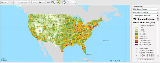
This data comes from a collaboration with the Vulcan Project, a NASA/Department of Energy funded effort based at Purdue University. The Vulcan Project has quantified US fossil fuel carbon dioxide (CO2) emissions at space and time scales much finer than has been achieved in the past.
Social Explorer users can explore carbon emissions data for 2002 here. Take a look at maps of the whole country and your own town to learn more about the distribution of emissions while the policy debates continue.