
Border policy and projects in West Texas are impacting Big Bend National Park and the communities that surround it. The U.S. Customs and Border Protection infrastructure expansion project would include proposed roads, surveillance equipment, and vehicle barriers including 17 miles of barriers cutting through Big Bend National Park. To advance the project, the Trump administration has waived environmental and historic-preservation laws. Amid pushback from a coalition of grassroots organizations, legal advocates, and local businesses, the project is on pause for the moment, but only after the bulldozers started digging. Initial construction and the backlash have put Big Bend National Park’s communities, landscape, and history in the spotlight. Social Explorer’s historical and current data resources can help researchers and the public learn more about the area.
The national park is a significant site of archaeological history and biodiversity. The human history of Big Bend goes back over 12,000 years to the era of the Paleo Indians. Brewster County, which surrounds the park, was established in 1887. In 1933, Texas created Texas Canyons State Park, which was soon renamed Big Bend State Park. The state later transferred the land to the federal government, and Big Bend National Park was officially established on June 12, 1944. Today, the 800,000 acre park is visited by more than half a million people each year.
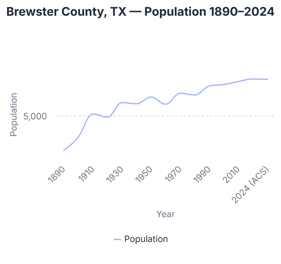
Social Explorer’s historical census data adds context and details to the area’s history. Brewster County has been a slow-growing rural place since its establishment. According to the 1890 Census, just three years after the county’s founding, Brewster had 710 residents. The 1940 Census, conducted four years before Big Bend became a national park, recorded 6,478 residents in Brewster County. From then to the most recent 2024 five-year American Community Survey estimates, the total population grew to 9,503 residents. The following chart of census and American Community Survey data shows the estimated growth of Brewster County from 1890 to 2024.
The county contains just three census tracts. Census tract 9505 encompasses most of the open land area and has a population density of just 0.5 persons per square mile. The other two Brewster County tracts (tract 9503 and 9504) are concentrated in Alpine, Texas, the home of Sul Ross State University. The following Social Explorer map shows the county’s geography and population distribution.
Educational attainment for the county is notably high: 45.47% of Brewster County residents hold a bachelor's degree or higher, exceeding Texas (33.82%) and the nation (35.68%). The following chart, created in Social Explorer, compares educational attainment among Brewster County residents age 25 and older with statewide and national rates.
%20Big%20Bend%20area.jpg)
The county's median age of 40.9 years exceeds state and national medians, driven by a substantially elevated share of residents aged 65 and older at 26.47% compared to 13.44% statewide and 17.21% nationally.
Racially and ethnically, the county is 51.31% White non-Hispanic and 42.07% Hispanic (any race), with smaller shares of Asian (1.86%) and Black (0.59%) residents. The following chart shows how the composition of Brewster County differs from Texas and the U.S.
%20Big%20bend%20area.jpg)
The national park and the university are the primary economic anchors of the area. Education and health care constitute the single largest industry (22%), driven primarily by Sul Ross State University in Alpine, which is the county's dominant employer. arts, entertainment, and recreation, and accommodation and food services is a close second (19%), a direct reflection of Big Bend National Park and the tourism economy, consisting of hotels, restaurants, outfitters, and related services. Public administration is third (14%), consistent with a county that hosts a national park (National Parks Service employees), a state university, and a large, remote territory requiring government services.
On the occupation side, management and professional roles (32%) and service occupations (31%) together account for nearly two-thirds of all jobs. Again, this is in line with a workforce shaped by a university and a tourism-driven economy. Agriculture, forestry, and mining (3.4%) is notably small given the county's ranching heritage. Median household income is $56,212 and median gross rent is $839, both below state and national figures.
Digging into Land-Cover Data Details
Detailed land data adds to the story of the Big Bend/Brewster County community. Brewster County is the largest of Texas’s 254 counties by land area, and, in fact, larger than Connecticut and Rhode Island combined. Social Explorer’s data library includes several environmental datasets. For instance, subscribers can access the National Land Cover Database (NLCD) Environmental Summaries, which include detailed information about different types of terrain.
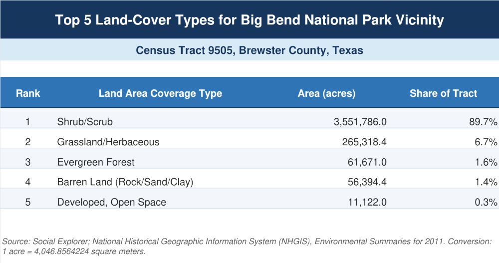
The top five land-cover types for the census tract including Big Bend National Park stand out for their unique abundance and blend of terrains. For example, the national park’s census tract includes 89.7% shrub/scrub land, which is more than twice the share for the state of Texas (39.3%).
Research Community Context and Impacts with Social Explorer
Social Explorer helps researchers examine the places and people shaped by public policy. Visit Social Explorer’s extensive data library and mapping tools to investigate communities in depth and over time.
New to Social Explorer? Sign up for a free Social Explorer account to try it out today.