


| Documentation: | Census 1970 on 2010 Geographies |
you are here:
choose a survey
survey
document
chapter
Publisher: U.S. Census Bureau
Survey: Census 1970 on 2010 Geographies
| Document: | 1970 Census Users' Guide - Part I |
| citation: | Social Explorer; U.S. Census Bureau; 1970 Census Users’ Guide; U. S. Government Printing Office, Washington, D. C., 1970. |
Chapter Contents
This section of the Census Users Dictionary describes the geographic areas recognized in census tabulations. Definitions specify:
The defining characteristics of the area. Both general and detailed descriptions are presented. Users who only require a general idea of a standard metropolitan statistical area, for example, need not look further than the first sentence or paragraph of the definition.
The agency which defines the area. Many areas are political entities such as States, counties, and municipalities with legally established boundaries. Others are identified by the Census Bureau or other governmental agencies based upon statistical criteria to satisfy particular information needs.
The number of units in each geographic category. For example, 50 States, 1,500 unincorporated places in 1960, 233 SMSAs in 1970. Many areas have increased in number over the past decade because of population growth (more units now meet certain population size minimums), such as urban places, or because they are now identified in larger portions of the country, such as tracts.
The censuses which recognize the area. This includes the population and housing, governments, agriculture, or economic censuses. Population and housing census tabulations recognize more types of areas than other censuses, particularly more types of smaller areas, primarily because the universe enumerated in this census - people and households - is larger, making it possible to present data without violating confidentiality requirements.
The type of geographic codes assigned to the area. Geographic codes, ranging in length from 1-digit to multi-digit characters, have been assigned to various political and statistical areas for control and tabulation purposes. For example, each township or equivalent area (including census county divisions) is assigned a numeric code in alphabetic sequence within the county.
The area definitions do not include a statement of the subject matter which is tabulated for each type of area. Generally speaking, the larger the area the greater the number and detail of the tabulations produced and published. In many cases, summary tapes contain data for areas smaller than are recognized in the printed reports. In addition, it is possible, in some cases, to obtain information for areas not recognized on the summary tapes or the printed reports on a contract basis. Smaller areas generally mean smaller numbers of reporting units. Hence, to avoid disclosure about individual units, data for these small areas sometimes must be suppressed.
In addition to taking into account the fact of suppression, users need to interpret small area tabulations with caution, particularly if the information was collected on a sample basis. Smaller numbers of reporting units in tally cells may lessen the reliability of the figures because of sampling fluctuations.
Changes in boundaries from one census to another can be expected. Therefore, users
desiring to analyze characteristics of particular areas--large or small--over time should be prepared to cope with the problem of area comparability.
The major political units of the United States. The 1970 State cedes, appearing on the summary tapes and related geographic products, are two-digit numbers assigned in sequence to States listed alphabetically. A listing of these codes is contained in the Federal Information Processing Standard Publication (FIPSPUB), Nos. 5 and 6.
The 1960 census State codes, also a two-digit numeric, were assigned by geographical divisions. The first digit indicates the geographic division within which the State is located and the second digit the State.
The 1960 census State codes, also a two-digit numeric, were assigned by geographical divisions. The first digit indicates the geographic division within which the State is located and the second digit the State.
A portion of a large State which is identified only for data processing purposes at the Census Bureau when data exceeds capacity of a single work unit. Two-digit numeric codes are assigned to Quasi-State areas when they appear in census summary tapes.
The 48 contiguous States and the District of Columbia. Alaska, Hawaii, and outlying areas are excluded.
Information for the Commonwealth of Puerto Rico, the Virgin Islands of the United States, and Guam is published in the reports of the censuses of agriculture, population, housing, business, manufacturers, and mineral industries. In addition, some census of population and housing reports show information for the Canal Zone and American Samoa. Population and housing totals are also available for the small outlying areas of Midway, Wake, Canton and Enderbury Islands, Johnston Island and San Island, the Swan Islands the Corn Islands, and the Trust Territory of the Pacific Islands.
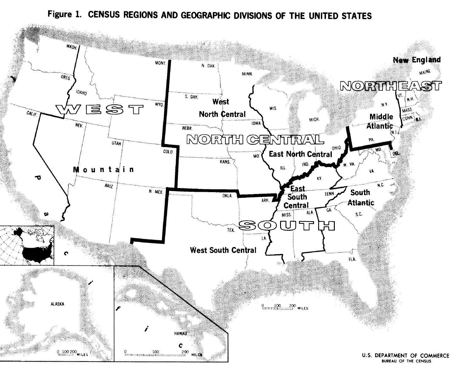
This is an area composed of contiguous States, with Alaska and Hawaii also included in one of the divisions. There are 9 geographic divisions and these have been used largely unchanged for the presentation of summary statistics census. See Figure 1.
A unit composed of two or more geographic divisions. There are 4 regions, although for some purposes the Northeast and North Central Regions have been combined into the North Region. See Figure 1.
These are single counties or groups of counties within a State which are relatively homogeneous with respect to economic and social characteristics. Boundaries are drawn in such a manner that each economic area has certain significant characteristics which distinguish it from adjoining areas. There are 509 SEAs.
The larger SMSAs are recognized as SEAs. In 1960, all SMSAs of 1,000,000 or more population constituted SEAs except: (1) in New England (SMSAs in New England are groups of cities and towns rather than counties); and (2) in cases where SMSA boundaries cross State lines, thereby necessitating designation of each States part of the SMSA as a separate SEA.
In 1970, the SEAs of 1960 will be used without change, SEAs are identified in census tabulations by a two-digit numeric code or a one digit alphabetic code and are assigned sequentially within the State.
The 121 ESRs are combinations of the 509 SEAs, each grouping bringing together those SEAs which are most closely related in terms of their economic and social characteristics. In order to achieve such homogeneity, State lines are frequently crossed. A three-digit numeric code is assigned to each Economic Sub-Region.
Counties are the primary political administrative divisions of the States, except in Louisiana where such divisions are called parishes, and in Alaska where 29 census divisions have been recently established as county equivalents. In 1960, census statistics for Alaska were shown for 24 election districts (reduced to 19 in 1961).
A number of cities (e. g., Baltimore, St. Louis, and many Virginia cities) are independent of any county organization and thereby constitute primary divisions of their States, A three-digit numeric code unique within State is assigned to each county. The codes used are those defined in the Federal Information Processing Standard Publications (FIPSPUBS) No. 6.
On the summary tapes, each summary record geographic identification carries two FIPSPUBS codes for county - the 1970 county code and the 1970 county of tabulation code. These two codes usually agree. However, users should note that when the 1970 county of tabulation code differs from the 1970 county code, a record had been assigned an incorrect 1970 county code, and the 1970 county of tabulation code represents a correction which should be followed in the aggregation of records.
In 1960, county tabulations included the District of Columbia and the three parts of Yellowstone National Park in Idaho, Montana, and Wyoming. In 1970, only the District of Columbia and the segment of Yellowstone National Park in Montana are included in county tabulations.
There were 3,134 counties and county equivalents in the U.S. in 1960. County maps are available which identify the minor civil division (or census county division), tract, place, and enumeration district boundaries.
On the 1970 summary tapes, a one-digit code, known as the central county code, indicates those counties that contain central cities of SMSAs, The insertion of an 0 in this field indicates
all those counties which contain SMSA central cities and a 1 for all counties which do not.
These areas are defined by State legislatures for the purpose of electing congressmen to the U.S. House of Representatives and may change after each decennial census. Congressional districts are identified by a two-digit numeric code which corresponds to the number assigned in State legislation, except on occasion 01 is used to identify areas in which members of Congress are elected at large, rather than by district.
Population and housing are the only censuses which tabulate statistics for the 435 congressional districts. Published census reports include only population totals for each district. These are found, along with much other census data, in the Congressional District Data Book and its supplements. Additional information from other censuses is presented only for districts made up of whole counties or for the smallest combination of split-county congressional districts following county lines. A series of reports from the 1964 Census of Agriculture shows data for congressional districts made up of whole counties.
Several population and housing data items are tabulated for each congressional district on the First Count summary tape.
Tabulations of the census of governments recognize independent school districts; dependent school systems are regarded as agencies of other governments and are therefore excluded. A drop in number from over 34,500 in 1962 to over 21,500 in 1967 is due primarily to consolidation and reorganization. School districts are not recognized for regular tabulations of the 1970 Census of Population and Housing.
Areas established to provide tabulations useful in analyzing the population growth of SMSAs near coasts, lakes and rivers. Water locations first appeared in the 1960 population census report titled Standard Metropolitan Statistical Areas, PC(3)-1D.
These are essentially single SMSAs or clusters of SMSAs selected to represent relatively large but geographically compact concentrations of industrial activity. They are utilized in some reports from the census of transportation. There are 25 of these areas.
Twenty of these units (defined by a Federal interagency committee) are recognized in a subject report from the census of manufactures, Water Use in Manufacturing. Each region is a combination of counties grouped to recognize major drainage basins.
Ten of these (defined by the Department of the Interior) have statistics printed in the report from the 1963 Census of Commercial Fisheries.
Statistics for 8 of these regions are presented in a report from the census of business on one of the whole sale trade businesses. They are defined by the Departments of Defense and the Interior and by the Executive Office of the President.
Statistics for the 10 regions are shown in the annual Current Industrial Report, Lumber Production and Mill Stocks.
Statistics for the areas for brick and structural clay tile (except surfacing tile) appear in the monthly Current Industrial Report Clay Construction Products.
These regions are located in Louisiana, Texas, and New Mexico. In Louisiana, they are composed of parishes, and in New Mexico and Texas they are composed of counties. Statistics for the 17 districts are shown in the reports on petroleum and natural gas industries in the census of mineral industries.
Statistics on U.S. imports and exports are published for many different areas. Information is shown for foreign countries, foreign, ports, Puerto Rico, U.S. Possessions (Virgin Islands, Wake-Island, Guam, and American Samoa), U.S. costal districts, U.S. customs districts, U.S. ports (including Great Lakes ports), and for combinations of trading areas.
Four classification schedules show the specific areas used in compiling the statistics. Foreign ports grouped into 20 major trading areas with 31 subdivisions are listed in Schedule K; definitions of these areas are in Schedule R. Foreign country designations made by the Census Bureau frequently include adjacent provinces, territories, islands and other areas; these are found in Schedule C. The American ports included in the 25 U.S. customs districts are in Schedule D. The schedules are available from the Census Bureau.
Four classification schedules show the specific areas used in compiling the statistics. Foreign ports grouped into 20 major trading areas with 31 subdivisions are listed in Schedule K; definitions of these areas are in Schedule R. Foreign country designations made by the Census Bureau frequently include adjacent provinces, territories, islands and other areas; these are found in Schedule C. The American ports included in the 25 U.S. customs districts are in Schedule D. The schedules are available from the Census Bureau.
Wards are political subdivisions of cities used for voting and representation purposes. These areas are usually reported in the population and housing census tabulations in cities of 3,000 or more which have provided boundary information. It is planned that 1970 census population totals for wards of cities with 10,000 or more will be published in the census reports; unpublished statistics for wards are available at the cost of photocopying the census tabulations. Ward statistics appeared in a Supplementary Report, PC (S1), of the 1960 Census of Population. The ward code is a two-digit number for each ward within a place of 3,000 or more population which contains wards.
In the census of governments reports, statistics are shown for types of government rather than for types of places, and the statistics for individual cities and towns are shown for either municipality or township governments. The term municipality includes all active governmental units officially designated cities, boroughs, villages, or towns (except in New England, New York and Wisconsin). This concept generally corresponds to the incorporated places that are recognized in the population and housing censuses. The term township as used in the census of governments refers to over 17,000 organized governments located in 17 States. The designation includes governments known officially as towns in New England, New York, and Wisconsin; some plantations in Maine; and locations in New Hampshire; as well as all governmental units officially called townships in other areas having this type of government.
These are the primary political and administrative subdivisions of a county; for example, towns, townships, precincts, magisterial districts, and gores. MCD tabulations are made for the census of population and housing. Each township or equivalent area (including census county divisions) is assigned a three-digit numeric code in alphabetic sequence within a county. Codes are not consecutive; gaps of five were allowed for addition of new units. In 1960, over 31,000 MCDs were recognized. Almost two-thirds of these were townships.
For those States in which MCDs are not suitable for presenting statistics, census county divisions (CCDs) are established by the Census Bureau.
In 1960, territories in counties that were not organized into MCDs were reported as a single unit in each county although they may have been split into several discontinuous pieces. In 1970, each separate discontinuous territory will be reported in one or more pieces and given a name. If the piece of unorganized territory in the county is large in area or population, it may be divided into named parts in a manner similar to the delineation of census county divisions. This program is limited to South Dakota, Minnesota, and Maine.
The publication code indicated on the summary tapes is a one-digit number assigned to specific minor civil divisions (MCDs) or census county divisions (CCDS) to indicate whether or not they will be included in printed reports. The codes include: 0=MCD/CCD records which are to be published; 1=MCD/CCD records which are independent coextensive incorporated places and are not to be published; 2 = the 19 Connecticut MCDs which are coextensive with dependent incorporated places and are to be published.
MCD-CCD maps are available by State and show township and city boundaries.
This term applies to a unit of tabulation appearing in file B of the First Count summary tape, MCD-places occur in the following situations in most States, the incorporated places form sub-units within minor civil divisions in which they are located; in other States, all or some of the incorporated places are themselves also minor civil divisions; and incorporated places, as well as unincorporated places, may be located in two or more minor civil divisions. An MCD-place is, therefore, any place which is either tabulated in segments, if the place straddles MCD boundaries, or tabulated as a whole, if the place is an MCD itself or a sub unit of an MCD.
In the 21 States for which MCDS are not suitable for presenting statistics, either because the areas have lost their original significance, are too small, have frequent boundary changes, or have indefinite boundaries, the Census Bureau has established relatively permanent statistical areas and designated them as CCDs.
The 18 States with CCDs in 1960 were: Alabama, Arizona, California, Colorado, Florida, Georgia, Hawaii, Idaho, Kentucky, Montana, New Mexico, Oregon, South Carolina, Tennessee, Texas, Utah, Washington, and Wyoming. In 1970, three additional States, Delaware, North Dakota, and Oklahoma, will have CCDs defined.
The population, housing, and agriculture censuses are the only ones for which CCD data have been tabulated. MCDs and CCDs are not recognized in tabulations of the 1969 Census of Agriculture, however. CCDs are defined with boundaries that seldom require change and can be easily located--e. g., roads, highways, power lines, streams, and ridges. The larger incorporated places are recognized as separate CCDs even though their boundaries may change as a result of annexations. Cities with 10,000 or more inhabitants generally are separate CCDs, and some incorporated places with as few as 1,000 population may be separate CCDs.
CCD boundaries were reviewed by county officials and various State agencies and were approved by either the governors or their representatives. Consideration was given to the trade or service areas of the principal settlements and in some instances to major land or physiographic differences.
Unincorporated enclaves within a city are included in the same CCD as the city. In tracted areas, each CCD is normally a single tract or group of tracts, or the combination of two CCDs represents one tract.
For 1970, most CCD counties with small populations that were single CCDs in 1960 have been split into two; also, some CCDs have been consolidated in SMSA counties where central cities have annexed all or major portions of surrounding small CCDs, and other CCDs have been modified or completely changed to agree with newly established census tracts.
MCD-CCD maps are issued by State and include township and city boundaries.
The term place, as used in the decennial population and housing census, refers to a concentration of population, regardless of the existence of legally prescribed units, powers, or functions. However, most of the places identified in the census are incorporated as cities, towns, villages, or boroughs, In addition, the larger unincorporated places are delineated.
A four-digit numeric code is assigned to each place in alphabetic sequence within State. Place codes are unique within States but place boundaries can cross county, MCD, or CCD lines. These codes are gapped at intervals of five digits to permit insertion of codes for additional places. There are about 20,000 places. In the six New England States, a four-digit New England town code, which is essentially a pseudo place code, is used to assign New England towns in alphabetic sequence with places within the State. The New England town codes were assigned at intervals of ten (larger than the place code intervals) to provide for insertion of new towns and places.
Since there are no incorporated places in Hawaii, there has always been a problem of recognizing and delimiting places in this State. Only two places, Honolulu and Hilo, have had legal boundaries. Since 1960, a program has been developed under the direction of the State legislature whereby the State Department of Planning and Economic Development has delineated boundaries of places with an estimated population of 300 or more, in cooperation with the Geography Division of the Census Bureau. The Bureau has agreed to treat these places, which are identified as cities, towns, and villages, in the same manner as incorporated places in other States.
A one-digit numeric code, which identifies places by type, appears on the summary tapes and is called the place description code. The codes are: (1) central city of an SMSA only, (2) central city of an urbanized area only, (3) central city of both an SMSA and an urbanized area, (4) other incorporated place, (5) unincorporated place, and (7) not a place. Code 6 is no longer used.
Places are classified on the summary tapes according to a two-digit place size code which identifies the size group (16 groups) into which a place falls on the basis of actual 1970 population. The size codes are: (00) under 200; (01) 200 to 499; (02) 500 to 999; (03) 1,000 to 1,499; (04) 1,500 to 1,999; (05) 2,000 to 2,499; (06) 2,500 to 4,999; (07) 5,000 to 9,999; (08) 10,000 to 19,999; (09) 20,000 to 24,999; (10) 25,000 to 49,999; (11) 50,000 to 99,999; (12) 100,000 to 249,999; (13) 250,000 to 499,999; (14) 500,000 to 999,999; (15) 1,000,000 or more.
The New England town size codes, also identified on the tapes, consist of the same codes and size groupings shown above.
Place maps may be purchased showing streets and containing enumeration district boundaries and also tract boundaries where applicable.
These are political units incorporated as cities, boroughs (excluding Alaska), villages, or towns (excluding New England States, New York, and Wisconsin). Most incorporated places are subdivisions of the minor civil divisions in which they are located; for example, an incorporated village located in an unincorporated township. Some incorporated places, however, constitute MCDs or cross MCD and county lines. Incorporated places never cross State lines since they are chartered by a State. In 1960, they numbered over 18,000.
Statistics for incorporated places of all types and sizes are given in the population and housing census reports; the figures for larger cities are quite detailed. The other censuses provide information for incorporated places of larger than a specified size:
2,500 in the census of governments and the retail trade and selected services segments of the census of business
5,000 in the wholesale trade segment of the census of business
10,000 in the census of manufactures.
In the census of business reports, statistics are shown for towns in New England and townships in Pennsylvania and New Jersey (not usually classified as incorporated places) with an urban population of 2,500 or more (5,000 for the wholesale trade segment) or a total population of 10,000 or more.
In the 1970 Census of Population and Housing, boroughs in Alaska are not included as incorporated places because they may include incorporated places within their limits and also they may include large areas with little population. Similarly excluded are towns in New England, New York, and Wisconsin. All townships are excluded.
Areas annexed to incorporated places of 2,500 or more inhabitants since the preceding census are recognized separately in certain decennial census tabulations. A one-digit annexation code on the summary tapes indicates areas annexed to cities since the previous census; 0 no and 5 = yes. A code 9 is used in some instances to identify areas annexed to smaller cities.
These are densely settled population centers which are not incorporated. Each has a definite residential nucleus, and boundaries are drawn by the Census Bureau to include insofar as possible, all the closely settled area. In the publications of the census of population and housing, statistics are shown, in all except urbanized areas, for unincorporated places of 1,000 or more population. In 1960, there were over 1,500 of these unincorporated places.
In order to recognize all unincorporated places of 1,000 or more outside the urbanized area, in unincorporated places are being enumerated separately in 1970 for settlements estimated to have at least 800 inhabitants, as was done in 1960. The Bureau has received varying degrees of cooperation from all the State highway departments in identifying and delineating these places and in providing maps; the coverage, therefore, should be more complete than ever before.
There will be no urban by special rule towns in New England or townships in New Jersey or Pennsylvania, as there were in the 1960 census. Unincorporated places may, instead, be defined for the built-up areas in any of these towns and townships which fall outside the urbanized areas.
Within the urbanized areas, except in New England, only unincorporated places of 5,000 inhabitants or more are recognized, in contrast to the 10,000 cutoff level in 1960. Census tract committees have aided greatly in extending the identification of these unincorporated places.
One further change, made with the consent of the Department of Defense, is to recognize and delineate military installations outside incorporated places; the parts of the installations that are built-up, are recognized as unincorporated places.
This designates all incorporated and unincorporated places of 2,500 or more. In 1960, towns in New England and townships in New Jersey and Pennsylvania, which contained no incorporated municipalities, had 25,000 or more inhabitants, or had from 2,500 to 25,000 inhabitants with a population density of 1,500 or more persons per square mile, were regarded as urban places; also included were counties in other States which contained no incorporated municipalities and had a density of 1,500 inhabitants or more per square mile. These special rules will not be applied in the 1970 census. There were almost 5,500 urban places in 1960 and will be over 6,000 in 1970.
According to the definition adopted for use in the 1960 censuses, the urban population comprised all persons living in:
A. Places of 2,500 inhabitants or more incorporated as cities, boroughs, villages, and towns (except towns in New England, New York, and Wisconsin).
B. The densely settled urban fringe, whether incorporated or unincorporated, of urbanized areas.
C. Towns in New England and townships in New Jersey and Pennsylvania which contain no incorporated municipalities as subdivisions and have either 25,000 inhabitants or more, or a population of 2,500 to 25,000 and a density of 1,500 persons or more per square mile.
D. Counties in States other than the New England States, New Jersey, and Pennsylvania that have no incorporated municipalities within their boundaries and have a density of 1,500 persons or more per square mile.
E. Unincorporated places of 2,500 or more inhabitants.
NOTE: Rules (C) and (D) have been dropped for the 1970 census. Therefore, rural areas are those remaining areas not falling into one of the categories set forth by definition (A), (B), or (E).
The Bureau of the Census uses a one-digit numeric code on the summary tapes to classify enumeration districts as urban, rural, or a combination of these. The urban - rural code designations are as follows: 0=urban and 1=rural.
An urbanized area contains a city (or twin cities) of 50,000 or more population (central city) plus the surrounding closely settled incorporated and unincorporated areas which meet certain criteria of population size or density. Beginning with the 1950 Censuses of Population and Housing, statistics have been presented for urbanized areas, which were established primarily to distinguish the urban from the rural population in the vicinity of large cities. They differed from SMSAs chiefly in excluding the rural portions of counties composing the SMSAs and excluding those places which were separated by rural territory from densely populated fringe around the central city. Also, urbanized areas are defined on the basis of the population distribution at the time of the census, and therefore the boundaries are not permanent.
Contiguous urbanized areas with central cities in the same SMSA are combined. Urbanized areas with central cities in different SMSAs are not combined, except that a single urbanized area was established in each of the two Standard Consolidated Areas.
Essentially the same definition criteria are being, followed in 1970 as in 1960 with two exceptions:
A. The decision not to recognize selected towns in New England and townships in Pennsylvania and New Jersey as urban places under special rules will affect the definition of some areas in these States. Included in urbanized areas will be only the portions of towns and townships in these States that meet the rules followed in defining urbanized areas elsewhere in the United States. This also affects Arlington County, Virginia, which will be considered an urban unincorporated place rather than an urban by special rule county.
B. A change has been introduced with regard to the treatment of extended cities (previously called overbounded) that contain large areas of very low density settlement. The decision to distinguish between urban and rural parts of extended cities in urbanized areas and to exclude the rural parts from the urbanized areas will help to present a more accurate representation of the population that is truly urban. Approximately sixty incorporated places are involved of which about twenty are central cities. An alphabetic code A appearing on the census summary tapes will identify these particular areas.
Pre-census planning indicated approximately fifty potential new urbanized areas. Those which prove to have a qualified central city or twin central cities in 1970 will appear in the published reports. Maps in the Metropolitan Map Series essentially cover the urbanized areas of SMSAs and contain all recognized census boundaries down to the block level.
Two sets of four digit numeric codes for urbanized areas are contained in the 1970 census tabulations. The potential urbanized area code will identify each record (collection of related data items) in each urban fringe zone. This zone includes all of the area which has the potential of being part of an urbanized area after the 1970 census. The actual urbanized area code uniquely identifies all records in each urbanized area. The final extent of the urbanized area and, therefore, each of the specific records that will contain this code is not determined until after the 1970 census.
The components of UAs and their specific definitional criteria are as follows:
An urbanized area contains at least one city which had 50,000 inhabitants in the census as well as the surrounding closely settled incorporated and unincorporated areas that meet the criteria for urban fringe areas. (There are a few urbanized areas where there are twin central cities that have combined population of at least 50,000. ) All persons residing in an urbanized area are included in the urban population.
In addition to its central city or cities, an urbanized area also contains the following types of contiguous areas, which together constitute its urban fringe:
A. Incorporated places with 2,500 inhabitants or more,
B. Incorporated places with less than 2,500 inhabitants, provided each has a closely settled area of 100 dwelling units or more.
C. Enumeration districts in unincorporated areas with a population density of 1,000 inhabitants or more per square mile. (The area of large nonresidential tracts devoted to such urban land uses as railroad yards, factories, and cemeteries is excluded in computing the population density.)
D. Other enumeration districts in unincorporated territory with lower population density provided that it serves one of the following purposes:
1. To eliminate enclaves
2. To close indentations in the urbanized area of one mile or less across the open end.
3. To link outlying enumeration districts of qualifying density that were no more than 1- 1/2 miles from the main body of the urbanized area.
A change in the definition since 1960 involves dropping the use of towns in the New England States, townships in ' New Jersey and Pennsylvania, and counties elsewhere which were classified as urban by special rule. These areas or their parts, will qualify as part of the urbanized area only if they meet rule C above.
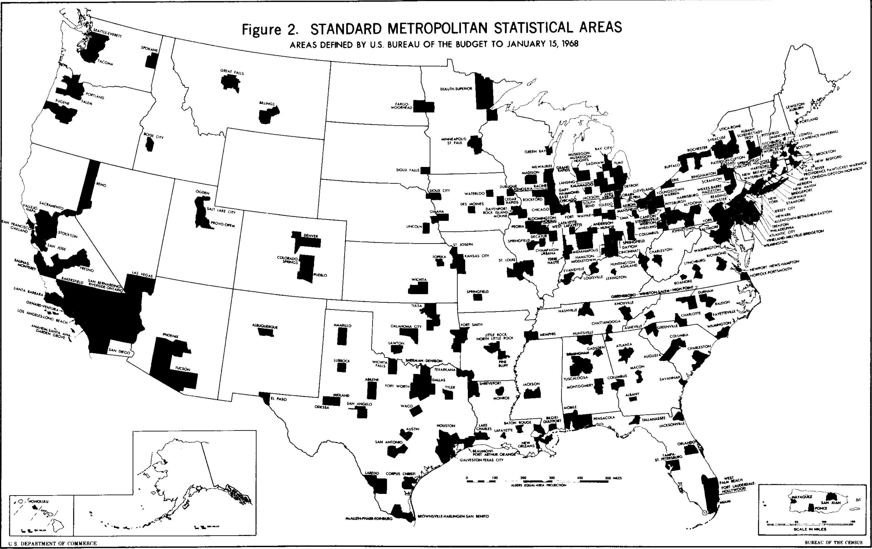
The concept of an SMSA has been developed in order to present general-purpose statistics. On the basis of the criteria listed below, the geographical boundaries of SMSAs are drawn by the Office of Statistical Policy in the Bureau of the Budget with the advice of representatives of the major Federal statistical agencies. A four-digit code identifies each SMSA. These codes are defined in Federal Information Processing Standard Publications, No. 8.
In 1960, there were 215 SMSAs in the United States and Puerto Rico; as of 1969, there are 233. Generally speaking an SMSA consists of a county or group of counties containing at least one city (or twin cities) having a population of 50,000 or more plus adjacent counties which are metropolitan in character and are economically and socially integrated with the central city. In New England, towns and cities rather than counties are the units used in defining SMSAs. The name of the central city or cities is used as the name of the SMSA. See Figure 2. There is no limit to the number of adjacent counties included in the SMSA as long as they are integrated with the central city nor is an SMSA limited to a single State; boundaries may cross State lines, as in the case of the Washington, D. C. - Maryland - Virginia SMSA.
Where the Current Population Reports series presents statistics for the metropolitan and nonmetropolitan populations, metropolitan refers to persons residing in SMSAs and nonmetropolitan refers to persons not residing in an SMSA even though they may live in a city.
Criteria for SMSAs:
A. Population size -- each SMSA must include at least:
1. One city with 50,000 inhabitants or more, or
2. Two cities having contiguous boundaries and constituting, for general economic and social purposes, a single community with a combined population of at least 50,000, the smaller of which must have a population of at least, 15,000. If two or more adjacent counties each have a city of 50,000 inhabitants or more and the cities are within 20 miles of each other (city limits to city limits), they will be included in the same area unless there is definite evidence that the two cities are not economically and socially integrated.
B. Metropolitan character of outlying counties- - specifically, the following criteria must be met:
1. At least 75 percent of the labor force of the county must be in the nonagricultural labor force.
2. The county must meet at least one of the following conditions:
a. It must have 50 percent or more ofits population living in contiguous minor civil divisions having a density of at least 150 persons per square mile, in an unbroken chain of minor civil divisions with such density radiating from a central city in the area.
b. The number of nonagricultural workers employed in the county must equal at least 10 percent of the number of nonagricultural workers employed in the county containing the largest city in the area, or the outlying county must be the place of employment of at least 10,000 nonagricultural workers.
c. The nonagricultural labor force living in the county must equal at least 10 percent of the nonagricultural labor force living in the county containing the largest city in the area, or the outlying county must be the place of residence of a nonagricultural labor force of at least 10,000.
C. Integration of central county and outlying counties-- sufficient economic and social communication:
1. At least 15% of the workers living in the given outlying county must work in the county or counties containing the central city or cities of the area, or
2. At least 25 percent of those working in the given outlying county must live in the county or counties containing the central city or cities of the area.
D. In New England, where city and town are administratively more important than the county and data are compiled locally for those minor civil divisions, cities and towns are the units used in defining SMSAs. Here, a population density criterion of at least 100 persons per square mile is used as the measure of metropolitan character and the integration criteria for the towns and cities are similar to criterion C.
The largest city in an SMSA is always a central city. One or two additional cities maybe secondary central cities in the SMSA on the basis and in the order of the following criteria:
A. The additional city or cities must have a population of one-third or more of that of the largest city and a minimum population of 25,000 except that both cities are central cities in those instances where cities quality under A, (2) of the criteria for SMSAs.
B. The additional city or cities must have at least 250,000 inhabitants.
In view of the special importance of the metropolitan complexes around two of the Nations largest cities, New York and Chicago, several contiguous SMSAs and additional counties that do not meet the formal integration criteria but do have other strong interrelationships have been combined into SCAs known as the New York- Northeastern New Jersey SCA, and the Chicago-Northwestern Indiana SCA. In census tabulations, a one-digit alphabetic code is assigned to these two SCAs. They are as follows: A= New York SMSA, Newark (N. J. ) SMSA, Jersey City (N. J. ) SMSA, Paterson- Clifton-Passaic (N.J.) SMSA, and Middle sex and Somerset Counties in New Jersey; B= Chicago SMSA and Gary-Hammond-East Chicago SMSA in Indiana.
All central cities of SMSAs, selected towns, and all counties and central business districts in the U.S. are assigned a five-digit numeric Universal Area Code. UACs are assigned to each area requiring separate identification in the population census tabulations of mobility and place of work. The level of a UAC is indicated in the tabulations by a one-digit numeric code. The levels are: County (1), Town (New England) (2), City (3), and Central Business District (4).
This is a concentration of retail stores located in an SMSA but not in the central business district of its chief city. (SMSAs may have more than one MRC.) To be considered an MRC, a shopping area must contain at least one major general merchandise store - usually a department store, MRCs include not only planned suburban shopping centers but also the older string street and neighborhood developments which meet the prerequisites. Frequently the boundaries of a single MRC include stores located within a planned shopping center as well as adjacent stores outside the planned portion. In general the boundaries of MRCs are established to include all the adjacent blocks containing at least one store in the general merchandise, apparel, or furniture-appliance groups of stores. In some cases MRCs are defined as census tracts.
The census of business is the only source of MRC statistics. In 1963, there were 972 MRCs identified in the 131 cities with CBDs; in 1967, there were 1,780 identified in almost all SMSAs.
The census of business is the only source of MRC statistics. In 1963, there were 972 MRCs identified in the 131 cities with CBDs; in 1967, there were 1,780 identified in almost all SMSAs.
The central business district is usually the downtown retail trade area of a city. As defined by the Census Bureau the CBD is an area of very high land valuation characterized by a high concentration of retail business offices, theaters, hotels, and service businesses, and with a high traffic flow. CBDs consist of one or more census tracts and have been defined only in cities with a population of 100,000 or more.
A one-digit numeric code, known as the Central Business District indication, denotes what tracted areas are to be tabulated as part of a CBD; 0 = yes and 1 = no.
A one-digit numeric code, known as the Central Business District indication, denotes what tracted areas are to be tabulated as part of a CBD; 0 = yes and 1 = no.
Census tracts are small, relatively permanent areas into which large cities and adjacent areas are divided for the purpose of providing comparable small-area statistics. Tract boundaries are determined by a local committee and approved by the Census Bureau; they conform to county lines. Tracts are originally designed to be relatively homogeneous with respect to population characteristics, economic status and living conditions; the average tract has about 4,000 residents. From time to time, changes may be made in tract boundaries; they are not necessarily comparable from census to census.
Census tracts are often used by local agencies in tabulating their own statistics. In 1960, there were over 23,000 tracts identified in 180 areas of the U.S. and Puerto Rico. All SMSAs presently recognized are completely tracted for the 1970 census. In addition, over 2,000 census tracts will be recognized in non- SMSA cities and counties. The 1970 total is about 34,600 tracts.
Each tract is assigned a six-digit numeric identification number. The first four digits are the basic code and the last two the suffix code. The suffix is only used when necessary to identify two or more tracts formed from a former single tract. The six-digit code appears on the Metropolitan Map Series maps as a large printed number, i.e., 14 (representing 0014--with no suffix) or 14.01 (representing 0014 with the suffix .01). The maps are printed without leading zeroes on the left but when the code is used in publications, the summary tapes and the Master Enumeration District List (MEDList), then (1) no period occurs, and (2) leading zeroes are used, e.g., 0014 or 001401 for a split tract. Basic tract codes can range from 1 to 9999 and the suffix codes range from 00 (shown blank) to 95. Suffix code 99 is reserved for crews of ships. The number is always unique within county, usually unique within SMSA and, in a few instances, within State.
The Tracted Area Code, a four-digit number that uniquely identifies all records in each tracted area, appears on the summary tapes. Tracted areas are usually SMSAs and adjacent territory (non-SMSA cities and counties).
Maps defining census tract boundaries will be included in the published tract reports. These maps will be similar to those of earlier censuses, in that tract outlines and numbers will be shown; other streets and features will be omitted. The names of streets which form tract boundaries will be included except for very short street segments.
In 1960, cities with a population of 1 million or more identified groups of tracts to form special areas for population and housing tabulations: Chicago - Community Areas; Detroit - Sub-community Areas; Los Angeles - Statistical Areas; New York - Health Areas; Philadelphia - Wards. No such areas will be identified in 1970 tabulations.
This is an area defined by the Office of Civil Defense. Special housing and population census tabulations are produced for use in OCDs damage assessment program. In 1960, SLAs consisted of tracts in tracted areas (tracts lying both inside and outside cities of 50,000 or more were regarded as split tracts and were treated as two separate SLAs); wards in untracted cities of 25,000 or more where wards are identified; groups of enumeration districts (averaging 5,000 population) in cities of 25,000 or more with neither tracts nor wards; urban places of 2,500 to 25,000 outside tracted areas; MCDs or CCDs, grouped where necessary to attain a minimum population of 2,000 in remaining areas. Standard Location Areas for 1970 have not yet been established.
A city block is normally a well-defined rectangular piece of land, bounded by streets and roads. However, it maybe irregular in shape or bounded by railroad tracks, streams or other features. Blocks may not cross census tract boundaries, but may cross other boundaries such as city limits. A three-digit numeric identification number is assigned to each block; its first digit is always one or greater. Block numbers are unique within each census tract.
Block data will be tabulated and published for all cities with populations of 50,000 or more prior to 1970. There are about 350 such cities.
Block data will also be tabulated and published for cities which may exceed 50,000 in 1970 and for approximately 900 cities and other areas that have contracted for block statistics. All block data discussed here will be available on census summary tapes.
The side of a city block; a segment of the periphery of a block or of a cul-de-sac into a block. Block faces can be identified using the Address Coding Guide and grouped to any specifications at request for a special tabulation.
This designation is new in 1970, and is used in census-by-mail areas where Address Coding Guides have been prepared. A block group is a combination of contiguous blocks having a combined average population of about 1,000. Block groups are approximately equal in area (discounting parks, cemeteries, railroads yards, industrial plants, rural areas, etc.); they are subdivisions of census tracts which simplify numbering and data control. Each block group is identified by the first digit of the three-digit block number. Block group 1 will contain any block in range 101-199, block group 2 in range 201-299, etc. However, normally only the first few numbers in a range are used. For purposes of providing small-area population and housing census data, they are the equivalent of enumeration districts within the mail-out/mail-back areas where Address Coding Guides have been prepared. Block groups (and blocks) are typically defined without regard to the boundaries of political or administrative areas, such as cities, minor civil divisions, and congressional districts. When a block group straddles one or more of these boundaries, data for those parts in different areas will be tabulated separately. Where such a split occurs, the tapes contain two (or more) data records having the same block group number within the census tract but a different place, annexation, minor civil division, or congressional district code depending on the situation. The First Count tapes do not contain a flag to indicate that a block group has been split; however, the Master Enumeration District List (MEDList) can be used to identify split block groups.
In the Address Coding Guide areas, block groups are actually split into so-called computer enumeration districts by the Census Bureau to facilitate data processing and enumeration follow-up. No tabulations are produced for these so called enumeration districts since they cannot be mapped as coherent geographic entities.
In the Address Coding Guide areas, block groups are actually split into so-called computer enumeration districts by the Census Bureau to facilitate data processing and enumeration follow-up. No tabulations are produced for these so called enumeration districts since they cannot be mapped as coherent geographic entities.
In untracted areas where city blocks will be tabulated on a contract basis, blocks have been numbered in block numbering areas which are identified by census tract-type numbers ranging from 9400.00 to 9999.00. Block numbering areas are also defined in parts of untracted counties that are within the 1970 potential urbanized area. Block numbering areas are unique within county boundaries and usually contain a population of about 4,000 people. Data are not tabulated for these areas.
Population and housing data from the decennial censuses have been published in a series of separate reports by census tract (primarily for SMSAs); a great many more statistics will be tabulated but not published and will be available at a nominal cost from the 1970 censuses.
Information about the census tract program is found in the Census Bureau's Census Tract Manual which tells how to get tracts established, outlines the responsibilities of local groups, tells about the large body of published and unpublished statistics which the Bureau has tabulated for census tracts, and reviews the ways tract statistics have been made more useful.
These small population areas average about 250 housing units and are defined by the Census Bureau. They are used for the collection and tabulation of population and housing census data for the conventional enumeration areas and for portions of the mail-out/mail-back SMSAs not covered by the Address Coding Guide.
A four-digit numeric code (ED basic code) is assigned sequentially to each ED within a county, and in some instances within a District Office territory. A one-digit alphabetic suffix code is used to indicate splits of original EDs. Another one-digit code, commonly called ED type, identifies an ED as being in one of the following areas: Address Coding Guide (0), Prelist (1), and Conventional (non-mail) (2). EDs in Address Coding Guide areas are called block groups.
Two administrative factors play a part in determining the geographic definition of enumeration districts. These are: (1) the estimated population size of the ED should constitute an adequate enumerator workload; and (2) the enumeration district must fall within the boundaries of certain areas for which the results are to be tabulated, i.e., tracts, cities, minor civil divisions, etc.
City boundaries often subdivide a census tract or minor civil division into several separate parts. These separate parts are often combined into a single enumeration district on the basis of the workload and boundary considerations described above. Each part is identified on the census map by the same ED number followed by the word Part. However, the data on the summary tape for this split ED are aggregated for the different parts and presented as a single record.
Temporary offices are set up in each of the Census Bureau's regional field office areas, the number for each area being determined primarily by the size and character of the population. Under the direction of the District Supervisor, crew leaders and their enumerators are selected and trained, and a all follow-up work is carried out. Incomplete forms are completed and non-responses are eliminated if possible. For control purposes, each of the approximately 400 District Offices has been assigned a four-digit numeric code. The first two digits indicate the Census Field Region and the two remaining ones the specific District Office within the Region. The District Office boundaries contain about one-half million people and may cross State lines.
This is a computer tape listing of all addresses for housing units (occupied or vacant) and other living quarters within addresses in selected areas receiving city delivery postal service in the mail-out/ mail-back census areas in 1970, It is used in preparing mailing labels and for drawing samples of housing units. This file is considered confidential and cannot be made available to anyone outside the Bureau of the Census.
New in 1970, this is an essential tool for the tabulation of census data in urbanized areas covered by the mail census. An ACG contains the actual or potential beginning and ending house numbers on every side of every block, (address range), the street name, the block and tract numbers and other geographic codes.
By referring to an ACG, persons requesting special tabulations from the Census Bureau will be able to define their own geographic units, to correspond to school districts, police precincts, etc. Copies of the guide are available to the public for the cost of reproduction.
By referring to an ACG, persons requesting special tabulations from the Census Bureau will be able to define their own geographic units, to correspond to school districts, police precincts, etc. Copies of the guide are available to the public for the cost of reproduction.
In the ACG, the lowest and highest addresses of a range of addresses on a block face. Both are odd or even, never mixed except through error. In most cases the potential address range is shown. An address range of zero (0) to zero may appear when a block side contains no addresses or the potential range is unknown. High and low addresses may be the same if there is only one address on a block face.
During the preparation of ACGs, a three-digit numeric code, known as the area code, was devised solely to provide an identification combining MCD and place codes. The area code was assigned to MCDs or CCDs alphabetically within county, and to all places within each MCD or CCD. Numbers were assigned at intervals of five, beginning with 005, (except in Cook County, Illinois and Allegheny County, Pennsylvania, where numbers were assigned at intervals of four, beginning with 004) to provide for insertion of new places and changes in alphabetic listing of MCD/CCDs. The MCD-place combination would have required seven digits if the normal codes were used.
Generally a five-digit identifier of a single record in the Address Coding Guide for an urbanized area. The serial number is unique within SMSA.
A suffix to the serial number, known as the check digit, is mathematically derived from the serial number and used to detect errors in transcribing or punching serial numbers. A typical use of the serial number is to identify records that are to be changed. When the serial number and its check digit are introduced into the computer (with other data), the check digit is recomputed and compared to that supplied. In the absence of a match, the entire record is rejected for correction of the error.
A suffix to the serial number, known as the check digit, is mathematically derived from the serial number and used to detect errors in transcribing or punching serial numbers. A typical use of the serial number is to identify records that are to be changed. When the serial number and its check digit are introduced into the computer (with other data), the check digit is recomputed and compared to that supplied. In the absence of a match, the entire record is rejected for correction of the error.
A five-digit numeric code for each street name in the Address Coding Guide. The street code is unique within postal finance areas. The postal finance area number (identification used by the Post Office Department) is the last 5-digits of the 7-digit Postal Data Code. The first two digits are a numeric State code. Postal Data Codes must be used with the street codes to distinguish among identical street codes in different postal finance areas.
For the 1970 census, in 145 SMSAs (and Appleton, Oshkosh, and Fond du Lac Wisconsin, areas which are not SMSAs) an Address Register compiled from a modified commercial mailing list was used to prepare individual address labels for the households in the city postal delivery area. In the balance of the metropolitan area, a special pre-listing was done and mailing pieces were addressed by hand; these addresses were not, however, put onto the computerized Address Register. About sixty percent of all households were part of this mail-out/mail-back system.
Questionnaires (either short forms or long forms) were left in mail boxes several days prior to April 1, 1970 and households were requested to place them in the return mail on census day. Follow-up-work was done by enumerator visit if the telephone did not suffice.
Questionnaires (either short forms or long forms) were left in mail boxes several days prior to April 1, 1970 and households were requested to place them in the return mail on census day. Follow-up-work was done by enumerator visit if the telephone did not suffice.
Some portions of SMSAs enumerated by the mail-out/mail-back procedure are not covered by the purchased mailing list. The Census Bureau made its own pre-listing of addresses in these areas. Mailing pieces for these areas were addressed by hand. There are no plans to add these addresses onto the computerized Address Register.
Areas other than the 145 SMSAs in the mail-out/mail-back area were enumerated essentially as the census has previously been conducted. Letter carriers left unaddressed short-form questionnaires at each housing unit on April 1, and the enumerator visited each unit, bringing the sample long-form questionnaires at that time for particular households.
Printed address lists, usually containing between 300 and 600 addresses clustered within a given area are used to facilitate the control of receipts and work assignment for following enumerators. These books are confidential and are not available to the public. In 1970, these books exist only in pre-list and non-mail areas.
The numeric codes and associated place names (where relevant) for a all areas recognized in regular or general census tabulations are carried on this computer tape. The smallest unit on the MRF is the city block in urbanized areas and the enumeration district in other areas. The codes are organized hierarchically (e. g., all the MCD codes for one county are grouped together, the county codes for the State, etc.). A selective printout of the MRF, called the Master Enumeration District List, is available for public use.
Contains relevant geographic codes and place names for the political and statistical subdivisions of States for which 1970 census data are tabulated. The MEDList is an expanded version of the 1960 Geographic Identification Code Scheme. The smallest unit on the MEDList is the block group in areas where Address Coding Guides have been developed and the enumeration district in all other areas. The MEDList contains a total population and housing unit count for each block group and enumeration district. The MEDList is needed in conjunction with the census use summary tapes and microfilm.
This system of the 1970 census creates a geographic base file for computer mapping. DIME records contain address ranges and block numbers for both sides of each street segment. Block boundaries other than streets (e. g., rivers, shorelines, and city limits) are also included. DIME records can also carry grid coordinates for street intersections and other major map features.
The DIME system makes possible a computer display of data on maps, calculation of the area of blocks and tracts, calculation of the distance between two points, retrieval of data for areas specified as lying within a given distance of a particular point, and the accomplishment of other analyses. DIME also ensures greater accuracy of the Address Coding Guide through use of a topological edit.
The Bureau of the Census is working with other Federal and local agencies to permit the addition of DIME features to already existing Address Coding Guides in most of the SMSAs included in the mail-out/mail-back census. Since the DIME system has several benefits over the ACG, it is also being used in nearly all non-mail SMSAs for creating a geographic base rile. This geographic base file program was made possible through the cooperation and funding of local participants and Federal agencies.
These areas are established by the Post Office for directing and sorting mail. ZIP areas are identified by 5-digit codes. The first 3 digits indicate a major city or sectional distribution center; the last 2 digits signify a specific post offices delivery area within the center. Zip areas do not coincide with census areas and will change according to postal requirements. They are not mutually exclusive areas and their boundaries do not necessarily follow clearly identifiable physical features.
ZIP areas were not recognized in any previous census. Fifth Count summary tapes will be the only source for population and housing data by ZIP Code. The allocation of the data to the ZIP Code areas will be accomplished as accurately as possible by prorating ED sample counts to their respective ZIP Codes.
ZIP areas were not recognized in any previous census. Fifth Count summary tapes will be the only source for population and housing data by ZIP Code. The allocation of the data to the ZIP Code areas will be accomplished as accurately as possible by prorating ED sample counts to their respective ZIP Codes.
This file lists all 35,000 U.S. post offices and the names of cities and towns within each (including variant names and spellings). The ZIP codes, 3-digit codes for multi-ZIP code post offices, and 5-digit codes for single ZIP code post offices, are included for each place name. The total file consists of over 100,000 records and is used for ZIP coding of incoming addresses which do not contain ZIP codes; it is available on request at cost.
This computer tape or printed listing of street names within post office area includes street codes and number ranges within ZIP code. It can be used to assign 5-digit ZIP codes to addresses with missing ZIP codes and for assigning street codes. Since this file contains no confidential information, it can be made available to the public on a cost basis.
The summary type code is a one-digit code designating the geographic level of summarization for each record on the First Count summary tape. Summary types are as follows: 0=State, 1=County, 2=MCD (CCD), 3=MCD (CCD) Place Segment, 4= Place, 5= Congressional District, 7= Enumeration District, 8 =Block Group. Code 6 is not applicable.
The record type is a numeric code (one or two digits in length) designating a particular kind of tabulation on the Third and Fourth Count summary tapes. It is used for sorting the records within these files. For example, file A of the Fourth Count is sorted by 1970 county of tabulation, tract number, and record type.
The record type is a numeric code (one or two digits in length) designating a particular kind of tabulation on the Third and Fourth Count summary tapes. It is used for sorting the records within these files. For example, file A of the Fourth Count is sorted by 1970 county of tabulation, tract number, and record type.

