


| Documentation: | ACS 2012 (5-Year Estimates) |
you are here:
choose a survey
survey
document
chapter
Publisher: U.S. Census Bureau
Survey: ACS 2012 (5-Year Estimates)
| Document: | ACS 2012-5yr Summary File: Technical Documentation |
| citation: | Social Explorer; U.S. Census Bureau; American Community Survey 2008-2012 Summary File: Technical Documentation. |
Chapter Contents
TThe following 2005-2009 5-year Summary File example is also applicable to this 5-year Summary File. Let's say that you want to create Table B08406, "Sex of Workers by Means of Transportation to Work for Workplace Geography," for the state of Alaska. Which files do you need? How do you read the files?
You will need files from www2.census.gov/acs2009_5yr/summaryfile/:
Next click on the folder 2005-2009_ACSSF_By_State_All_Tables. Then click on the file Alaska_All_Geographies_Not_Tracts_Block_Groups.zip and extract the files e20095ak0003000.txt, m20095ak0003000.txt, and g20095ak.txt
When you open the estimate file, e20095ak0003000.txt, you will see the following comma- delimited fields on the first line:
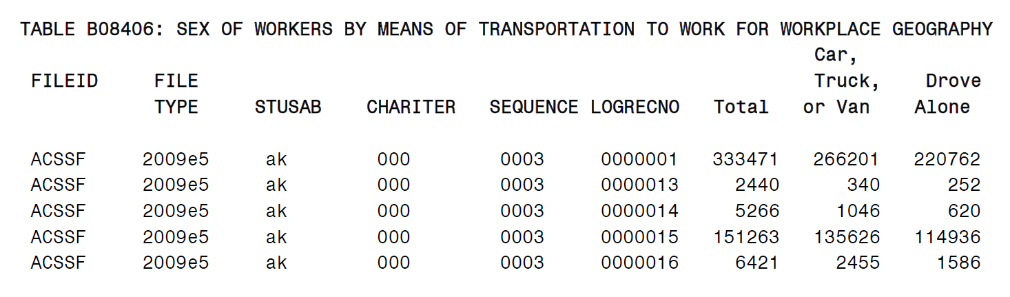
ACSSF,2009e5,ak,000,0003,0000001,333471,266201,220762,45439,36132,5602,3705,...
The first six fields - from "ACSSF" to "0000001" - are identifiers:
Then use the geography file for Alaska to determine the location within the state to which the data refer. The appropriate file is g20095ak.txt, where "g" stands for geography, "2009" is the year, "5" is the period estimate (in this case, 5-year estimate), and "ak" is the state. The geography file, g20095ak.txt, defines the LOGRECNO. Each LOGRECNO in this file specifies a geographic area pertaining to the state. For example, a LOGRECNO of "0000001" means the state of Alaska; a LOGRECNO of "0000002" means just the urban areas in Alaska; a LOGRECNO of "0000003" refers to just rural areas in Alaska. (Each state geography file also contains the lower-case FIPS State Code.) Please be aware that each state has its own geography file. For more information, see Chapter 2.4.
Glancing back at the Sequence Number and Table Number Lookup file, you will see that Table 08406 in sequence "0003" begins at the seventh position. From this point forward, for 51 fields (indicated on the same file), each field corresponds to the value of a "line number" in the table. So, field number seven, the 333471 value, corresponds to line number one, which is "Total". Field number eight, the 266201 value, refers to line number two, which is "Car, Truck, or Van." Field number nine, the 220762 value, corresponds to line number three, which is "Drove alone." This continues all the way up to line number 51, at which point Table B08406 ends.
Were you to read all these files into a computer program using software such as SAS, you could translate the first nine fields of e20095ak0003000.txt as follows:
Merging the geography file, the table shell, and the estimate and margin of error files together creates an excerpt of Table B08406, shown below:
You will need files from www2.census.gov/acs2009_5yr/summaryfile/:
- The Sequence_Number_and_Table_Number_Lookup.xls spreadsheet
- The zipped file 20095ak0003000.zip containing the estimate file e20095ak0003000.txt, the margin of error file m20095ak0003000.txt, and the geography file g20095ak.txt. All these data files are in folder 2005-2009_ACSSF_By_State_All_Tables
Next click on the folder 2005-2009_ACSSF_By_State_All_Tables. Then click on the file Alaska_All_Geographies_Not_Tracts_Block_Groups.zip and extract the files e20095ak0003000.txt, m20095ak0003000.txt, and g20095ak.txt
When you open the estimate file, e20095ak0003000.txt, you will see the following comma- delimited fields on the first line:
ACSSF,2009e5,ak,000,0003,0000001,333471,266201,220762,45439,36132,5602,3705,...
The first six fields - from "ACSSF" to "0000001" - are identifiers:
- The first field tells you that this is an ACS Summary File;
- The second tells you that these data are five-year estimates for the year 2005-2009 (notice the "e" before "2009" and the "5" at the end);
- The third tells you the state, ie. "ak" is Alaska;
- The fourth is an iteration number 000;
- The fifth is the sequence number 0003,
- The last is a logical record code LOGRECNO 0000001. Use LOGRECNO to determine the geographic area within a state.
Then use the geography file for Alaska to determine the location within the state to which the data refer. The appropriate file is g20095ak.txt, where "g" stands for geography, "2009" is the year, "5" is the period estimate (in this case, 5-year estimate), and "ak" is the state. The geography file, g20095ak.txt, defines the LOGRECNO. Each LOGRECNO in this file specifies a geographic area pertaining to the state. For example, a LOGRECNO of "0000001" means the state of Alaska; a LOGRECNO of "0000002" means just the urban areas in Alaska; a LOGRECNO of "0000003" refers to just rural areas in Alaska. (Each state geography file also contains the lower-case FIPS State Code.) Please be aware that each state has its own geography file. For more information, see Chapter 2.4.
Glancing back at the Sequence Number and Table Number Lookup file, you will see that Table 08406 in sequence "0003" begins at the seventh position. From this point forward, for 51 fields (indicated on the same file), each field corresponds to the value of a "line number" in the table. So, field number seven, the 333471 value, corresponds to line number one, which is "Total". Field number eight, the 266201 value, refers to line number two, which is "Car, Truck, or Van." Field number nine, the 220762 value, corresponds to line number three, which is "Drove alone." This continues all the way up to line number 51, at which point Table B08406 ends.
Were you to read all these files into a computer program using software such as SAS, you could translate the first nine fields of e20095ak0003000.txt as follows:
Merging the geography file, the table shell, and the estimate and margin of error files together creates an excerpt of Table B08406, shown below:
| Table ID | Line Number | Sequence Number | Table Title | Estimates | Margin of Error |
| B08406 | 003 | SEX OF WORKERS BY MEANS OF TRANSPORTATION TO WORK FOR WORKPLACE GEOGRAPHY | |||
| B08406 | 003 | Universe: Workers 16 years and over | |||
| B08406 | 1 | 003 | Total: | 333,471 | +/-2,630 |
| B08406 | 2 | 003 | Car, truck, or van: | 266,201 | +/-2,589 |
| B08406 | 3 | 003 | Drove alone | 220,762 | +/-2,439 |
| B08406 | 4 | 003 | Carpooled: | 45,439 | +/-1,795 |
| B08406 | 5 | 003 | In 2-person carpool | 36,132 | +/-1,596 |
Here is an example of how to access the Summary Files for one table for all geographies from the ACS summary file. The following 2005-2009 5-year Summary File example is also applicable to this 5-year Summary File.
Question: I am interested in downloading table B01001 for all published ACS geographies, how would I do this?
1)Go to the Sequence Number and Detailed Table Number Lookup File (Chapter 2.3) to locate sequence number for table B01001. There are Excel and SAS dataset versions of the file. They are available at http://www2.census.gov/acs2009_5yr/summaryfile/
2)Use the Summary File SAS Example Macros located at http://www2.census.gov/acs2012_5yr/summaryfile/UserTools/. Run the macro:
%TableShell(B01001);
This macro will provide metadata information on a given table, in this case B01001.
3)The following SAS dataset will be created with information about table B01001:
We can see that table B01001 is located in Sequence 0013; this applies to all published geographies.
4) We can read into SAS all tables in the 0013 sequence by running the SAS Example Macros:
%CallSt;
This macro will run a do loop creating State two-digit abbreviations, which will allow a simple way to read the Summary Files into SAS for all geographies. Each time a valid two digit state abbreviation is created, the macro %AllSeqs is run with the two digit state abbreviation.
The %Allseqs Macro performs the following tasks:
A.Read the geographic header file - %AnyGeo Macro.
B.There is a do loop to allow you to choose which sequences you would like to read in for example if you wanted sequence 0010 set the loop to be do x=13 %to 13; - The 0 values will be filled in.
C.Within the do loop the following macros will be executed:
a.%TablesBySeq, -- This will give information about the whole 0003 sequence, not just table B01001.
b.%ReadDataFile - This macro is called two times once for each type of estimate. This macro will generate and run SAS code for each sequence specified in the do loop in step 2 and for each geography specified in the %Callst macro.
c.Lastly, there is a merge statement that will merge together each of the three types of estimates and the geography header file by sequence number per geography.
5) You now will have all tables in the 0013 sequence read into SAS in the following dataset names, if the code is not modified, in the work directory Sf0013.sas7bdat.
Question: I am interested in downloading table B01001 for all published ACS geographies, how would I do this?
1)Go to the Sequence Number and Detailed Table Number Lookup File (Chapter 2.3) to locate sequence number for table B01001. There are Excel and SAS dataset versions of the file. They are available at http://www2.census.gov/acs2009_5yr/summaryfile/
2)Use the Summary File SAS Example Macros located at http://www2.census.gov/acs2012_5yr/summaryfile/UserTools/. Run the macro:
%TableShell(B01001);
This macro will provide metadata information on a given table, in this case B01001.
3)The following SAS dataset will be created with information about table B01001:
| Table ID | Sequence Number | Line Number | Start Position | Total Cells in Table | Total Cells in Sequence | Table Title |
| B01001 | 0013 | 7 | 49 CELLS | SEX BY AGE | ||
| B01001 | 0013 | Universe: Total population | ||||
| B01001 | 0013 | 1 | Total: | |||
| B01001 | 0013 | 2 | Male: | |||
| B01001 | 0013 | 3 | Under 5 years | |||
| B01001 | 0013 | 47 | 75 to 79 years | |||
| B01001 | 0013 | 48 | 80 to 84 years | |||
| B01001 | 0013 | 49 | 85 years and over |
We can see that table B01001 is located in Sequence 0013; this applies to all published geographies.
4) We can read into SAS all tables in the 0013 sequence by running the SAS Example Macros:
%CallSt;
This macro will run a do loop creating State two-digit abbreviations, which will allow a simple way to read the Summary Files into SAS for all geographies. Each time a valid two digit state abbreviation is created, the macro %AllSeqs is run with the two digit state abbreviation.
The %Allseqs Macro performs the following tasks:
A.Read the geographic header file - %AnyGeo Macro.
B.There is a do loop to allow you to choose which sequences you would like to read in for example if you wanted sequence 0010 set the loop to be do x=13 %to 13; - The 0 values will be filled in.
C.Within the do loop the following macros will be executed:
a.%TablesBySeq, -- This will give information about the whole 0003 sequence, not just table B01001.
b.%ReadDataFile - This macro is called two times once for each type of estimate. This macro will generate and run SAS code for each sequence specified in the do loop in step 2 and for each geography specified in the %Callst macro.
c.Lastly, there is a merge statement that will merge together each of the three types of estimates and the geography header file by sequence number per geography.
5) You now will have all tables in the 0013 sequence read into SAS in the following dataset names, if the code is not modified, in the work directory Sf0013

