


| Documentation: | ACS 2009 (1-Year Estimates) |
you are here:
choose a survey
survey
document
chapter
Publisher: U.S. Census Bureau
Survey: ACS 2009 (1-Year Estimates)
| Document: | ACS 2009-1yr Summary File: Technical Documentation |
| citation: | Social Explorer; U.S. Census Bureau; American Community Survey 2009 Summary File: Technical Documentation. |
Chapter Contents
This chapter is intended to provide a guide for data users to the American Community Survey Summary Files. New users should review this chapter before attempting to use the Summary File product.
The American Community Survey Summary Files (ACS-SF) are available in .zip file format. The Zip file format is a compressed format used to reduce the file size. Users can download the .zip files through the File Transfer Protocol (FTP) from the American Community Survey FTP site located at: http://www2.census.gov/acs2009_1yr/summaryfile/. To read the Summary Files data, the compressed files must be uncompressed (unzipped) to allow access to the data.
Based on user feedback, the ACS Summary File is now organized into three categories
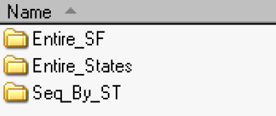
1. Entire_SF: This zip file contains all of the Summary File data, MOE's, and geography files - 1 File in Directory /acs2009_1yr/summaryfile/Entire_SF/20091YRSF.zip
For the user' s convenience, this zip file contains all of the Summary Files for the U.S., Puerto Rico, states, and District of Columbia. For example, to obtain all Summary Files for nation (U.S.), states, District of Columbia, and Puerto Rico, just download and unzip the file 20091YRSF.zip.
2. Entire_States: These files contain all of the summary file data, MOE's, and geography files per state - 53 Files in Directory (50 States, 1 US, DC, PR) /acs2009_1yr/summaryfile/Entire_States/.zip
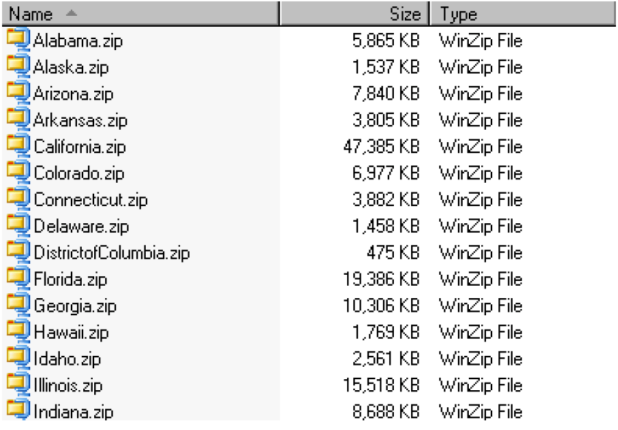
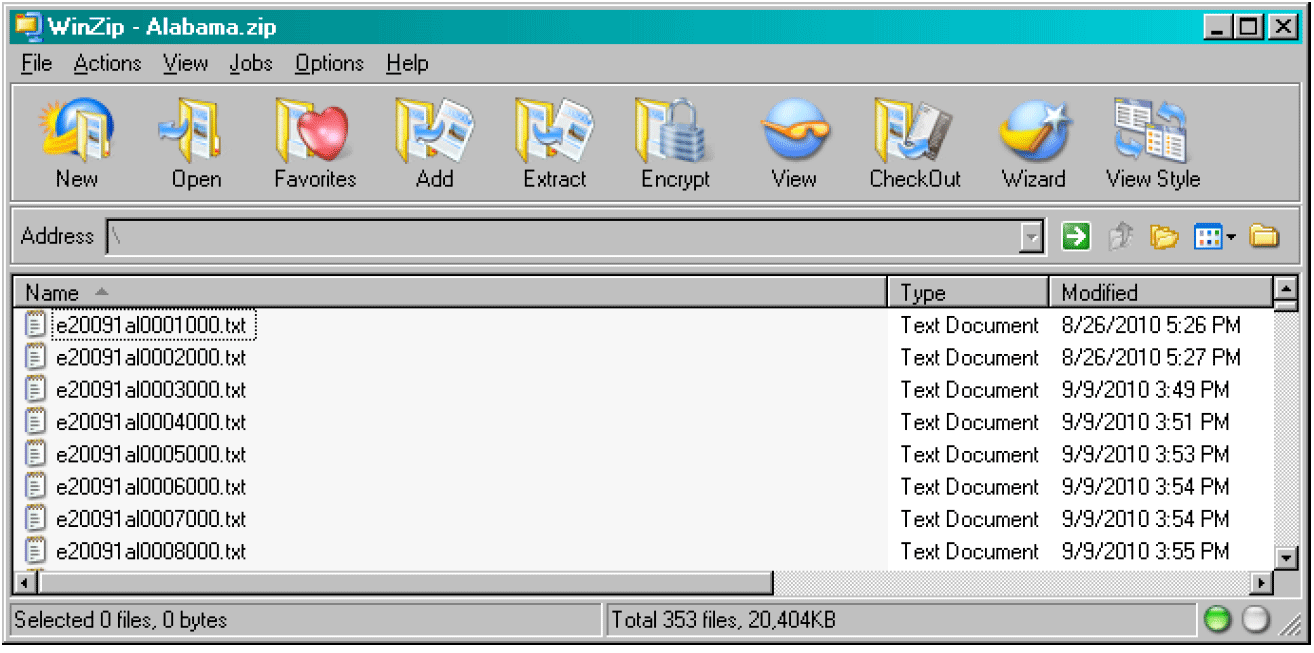
This directory contains 53 zip files that include the United States, each of the 50 states, District of Columbia, and Puerto Rico. Each zip file contains 176 estimate files, 176 Margin of Error files, and 1 geography file. See partial contents of the zip file for Alabama below.
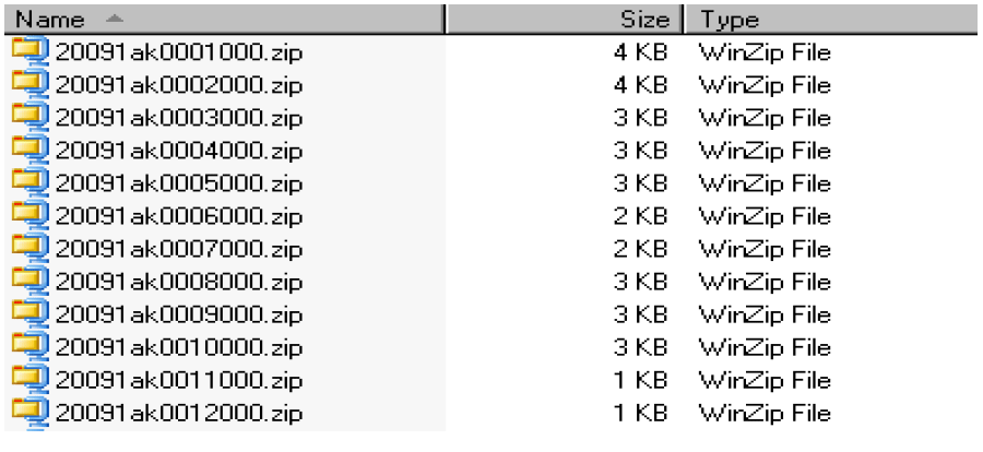
3. Seq_By_ST: 53 directories with 176 Compressed Sequence Files (both Estimates & MOE's) and 1 Geography file in each directory /acs2009_1yr/summaryfile/Seq_By_ST//.zip
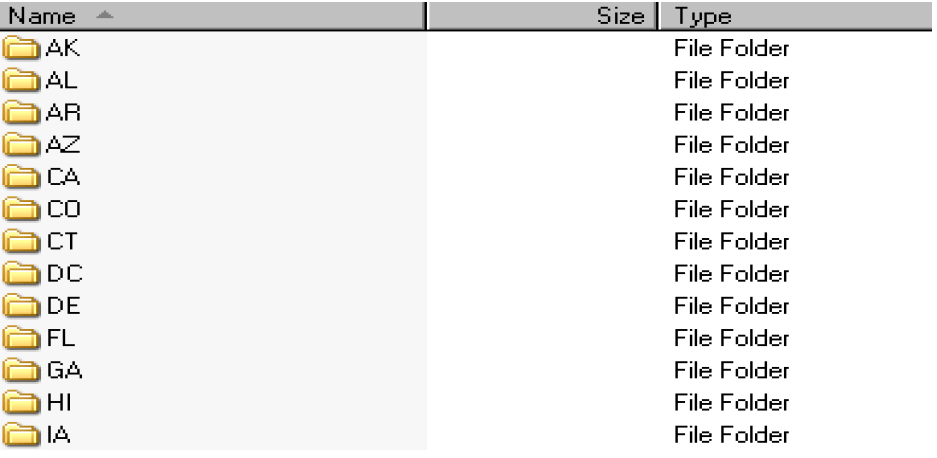
Each directory contains 176 zip files and 1 geography file. Each zip file containing 1 estimate and 1 Margin of Error file. See a partial view of the AK directory below:
1. Entire_SF: This zip file contains all of the Summary File data, MOE's, and geography files - 1 File in Directory /acs2009_1yr/summaryfile/Entire_SF/20091YRSF.zip
For the user' s convenience, this zip file contains all of the Summary Files for the U.S., Puerto Rico, states, and District of Columbia. For example, to obtain all Summary Files for nation (U.S.), states, District of Columbia, and Puerto Rico, just download and unzip the file 20091YRSF.zip.
2. Entire_States: These files contain all of the summary file data, MOE's, and geography files per state - 53 Files in Directory (50 States, 1 US, DC, PR) /acs2009_1yr/summaryfile/Entire_States/
This directory contains 53 zip files that include the United States, each of the 50 states, District of Columbia, and Puerto Rico. Each zip file contains 176 estimate files, 176 Margin of Error files, and 1 geography file. See partial contents of the zip file for Alabama below.
3. Seq_By_ST: 53 directories with 176 Compressed Sequence Files (both Estimates & MOE's) and 1 Geography file in each directory /acs2009_1yr/summaryfile/Seq_By_ST/
Each directory contains 176 zip files and 1 geography file. Each zip file containing 1 estimate and 1 Margin of Error file. See a partial view of the AK directory below:
The naming convention used for the Summary Files provides a hierarchy to allow for easier navigation to the desired information. Figures 2.1 and 2.2 provide an overview of the summary file naming convention.
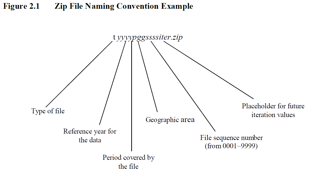
Each sequence number will correspond to a series of detailed tables. Each record of this file will be for a unique geographic area published by the ACS. All the data cells contained in the detailed tables for that geographic area would be on this record. There will be a file for the estimates and a separate one for the standard errors.
- t = type of data (e=estimate, m=margin of error, s=standard error)
- yyyy = reference year for the data, e.g., 2009
- p = period covered by the file (1=1-year, 3=3-year, 5=5-year)
- gg = geographic area (state or US) covered by the file; 'PR' for the Puerto Rico Community Survey
- ssss = file sequence number (valid range is 0001 through 9999)
Each sequence number will correspond to a series of detailed tables. Each record of this file will be for a unique geographic area published by the ACS. All the data cells contained in the detailed tables for that geographic area would be on this record. There will be a file for the estimates and a separate one for the standard errors.
- iter = ' 000, placeholder for future values for iteration
- r = data revision indicator, only present if needed. 'a' , 'b' , etc
- t = type of data (g= geographic header file)
- yyyy = reference year for the data, e.g., 2009
- p = period covered by the file (1=1-year, 3=3-year, 5=5-year)
- gg = geographic area is represented by 2 digit FIPS state code
The geographic file layout is below (Table 2.1). The geographic file provides the reference name, field description, field size, field starting position, and geographic summary levels that apply. The information pertaining to summary level identifies additional geographic information. Each record of the geographic file contains particular geographic area codes. For example, the reference name "PLACE" only contains information for summary levels 160 - State-Place, 312 - Metropolitan Statistical Area/Micropolitan Statistical Area-State-Principal City and 352 - New England City and Town Area-State-Principal City. For more detail on geographic definitions, see "Appendix A. Geographic Terms and Concepts".
Table 2.1 Geographic Header Record Layout for the ACS Summary File
The Geographic Summary Levels labeled as "Reserved for future use" will be used for the ACS period estimate data products.
Table 2.1 Geographic Header Record Layout for the ACS Summary File
| Data Dictionary Reference Name | Description | Field Size | Starting Position | Geographic Summary Levels For Single-Year Tables |
|---|---|---|---|---|
| RECORD CODES | ||||
| FILEID | Always equal to ACS Summary File identification | 6 | 1 | All Summary Levels |
| STUSAB | State Postal Abbreviation | 2 | 7 | All Summary Levels |
| SUMLEVEL | Summary Level | 3 | 9 | All Summary Levels |
| COMPONENT | Geographic Component | 2 | 12 | All Summary Levels |
| LOGRECNO | Logical Record Number | 7 | 14 | All Summary Levels |
| GEOGRAPHIC AREA CODES | ||||
| US | US | 1 | 21 | 010 |
| REGION | Census Region | 1 | 22 | 020 |
| DIVISION | Census Division | 1 | 23 | 030 |
| STATECE | State (Census Code) | 2 | 24 | Blank for All Summary Levels |
| STATE | State (FIPS Code) | 2 | 26 | 040, 050, 060,160, 230, 312, 352, 500, 795, 950, 960, 970, M01, M06, M07, M08, M11, M15, P01, P06, P07, P08, P11, P15 |
| COUNTY | County of current residence | 3 | 28 | 050, 060, M01, M08, P01, P08 |
| COUSUB | County Subdivision (FIPS) | 5 | 31 | 060, M08, P08 |
| PLACE | Place (FIPS Code) | 5 | 36 | 160, 312, 352, M07, M11, M15, P07, P11, P15 |
| BLANK | 6 | 41 | Reserved for future use | |
| BLANK | 1 | 47 | Reserved for future use | |
| BLANK | 5 | 48 | Reserved for future use | |
| AIANHH | American Indian Area/Alaska Native Area/ Hawaiian Home Land (Census) | 4 | 53 | 250 |
| AIANHHFP | American Indian Area/Alaska Native Area/ Hawaiian Home Land (FIPS) | 5 | 57 | 250 |
| BLANK | 1 | 62 | Reserved for future use | |
| BLANK | 3 | 63 | Reserved for future use | |
| BLANK | 5 | 66 | Reserved for future use | |
| ANRC | Alaska Native Regional Corporation (FIPS) | 5 | 71 | 230 |
| CBSA | Metropolitan and Micropolitan Statistical Area | 5 | 76 | 310, 312, 314, 332, M10, M11, M12, P10, P11, P12 |
| CSA | Combined Statistical Area | 3 | 81 | 330, M09, P09 |
| METDIV | Metropolitan Statistical Area-Metropolitan Division | 5 | 84 | 314, M12, P12 |
| MACC | Metropolitan Area Central City | 1 | 89 | |
| MEMI | Metropolitan/Micropolitan Indicator Flag | 1 | 90 | 010, 020, 030, 040, 314 |
| NECTA | New England City and Town Area | 5 | 91 | 350, 352, 355, M14, M15, M16, P14, P15, P16 |
| CNECTA | New England City and Town Combined Statistical Area | 3 | 96 | 335, M13, P13 |
| NECTADIV | New England City and Town Area Division | 5 | 99 | 355, M16, P16 |
| UA | Urban Area | 5 | 104 | 400 |
| BLANK | 5 | 109 | Reserved for future use | |
| CDCURR | Current Congressional District *** | 2 | 114 | 500 |
| BLANK | 3 | 116 | Reserved for future use | |
| BLANK | 3 | 119 | Reserved for future use | |
| BLANK | 6 | 122 | Reserved for future use | |
| BLANK | 3 | 128 | Reserved for future use | |
| BLANK | 5 | 131 | Reserved for future use | |
| SUBMCD | 5 | 136 | Reserved for future use | |
| SDELM | State-School District (Elementary) | 5 | 141 | 950 |
| SDSEC | State-School District (Secondary) | 5 | 146 | 960 |
| SDUNI | State-School District (Unified) | 5 | 151 | 970 |
| UR | Urban/Rural | 1 | 156 | 010, 020, 030, 040 |
| PCI | Principal City Indicator | 1 | 157 | 010, 020, 030, 040, 312, 352 |
| BLANK | 6 | 158 | Reserved for future use | |
| BLANK | 5 | 164 | Reserved for future use | |
| PUMA5 | Public Use Microdata Area - 5% File | 5 | 169 | 795 |
| BLANK | 5 | 174 | Reserved for future use | |
| GEOID | Geographic Identifier | 40 | 179 | All Summary Levels |
| NAME | Area Name | 200 | 219 | All Summary Levels |
The Geographic Summary Levels labeled as "Reserved for future use" will be used for the ACS period estimate data products.
The first six columns of the estimates and margin of error files provide data and geographic information related to the tables contained within the same row.
A logical unique record number is assigned to all files for a specific geographic entity so that all records for a specific entity can be linked together across files. Besides the logical record number, other identifying fields are also carried over from the geographic header file to the table files. For more details on these fields, see the example below.
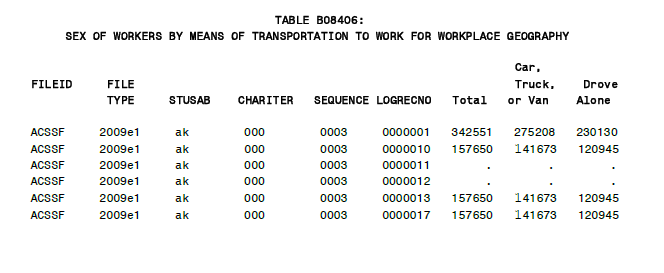
- FILEID = File Identification - 6 characters
- FILETYPE= File Type - 6 characters
- STUSAB = State/U.S.-Abbreviation (USPS) - 2 characters
- CHARITER= Character Iteration - 3 characters
- SEQUENCE= Sequence Number - 4 characters
- LOGRECNO= Logical Record Number - 7 characters
A logical unique record number is assigned to all files for a specific geographic entity so that all records for a specific entity can be linked together across files. Besides the logical record number, other identifying fields are also carried over from the geographic header file to the table files. For more details on these fields, see the example below.
There are a few simple rules that are followed in the organization of tables into sequences in the ACS Summary File.
There are never more than 245 cells in a sequence. Tables are grouped into sequences according to their subject area.
Tables from different subject areas are not combined into the same sequence. Tables are grouped together when they share a collapsing arrangement. (Group B & C tables in same sequence.) For example, tables B02003 and C02003 should be in the same sequence. Place of Work (POW) tables are not grouped together with Place of Residence (POR) tables.
The data from the American Community Survey contain approximately 75 detailed tables that have different table layouts for the Puerto Rico Community Survey. The United States tables are limited to geographic areas within the United States that includes all 50 states plus the District of Columbia. The Puerto Rico tables are limited to areas within Puerto Rico. Separation of files between US and Puerto Rico was made because the comparable tables may have a different number of cells (such as C06001 with 45 cells and C06001PR with 37 cells). To identify what tables are available for Puerto Rico only look for the "PR" suffix in the table id (e.g. C06001PR). For more information on PR only sequences that are counterparts to states-only sequences, please reference the following table.
Sequences 126-143 contain 6 large median tables with 499 cells. Due to the size restriction on the sequences (no more than 245 cells), each of the tables is broken down into 3 sequences. These tables are only produced for the U.S. Please reference the following table for more details.
There are never more than 245 cells in a sequence. Tables are grouped into sequences according to their subject area.
Tables from different subject areas are not combined into the same sequence. Tables are grouped together when they share a collapsing arrangement. (Group B & C tables in same sequence.) For example, tables B02003 and C02003 should be in the same sequence. Place of Work (POW) tables are not grouped together with Place of Residence (POR) tables.
The data from the American Community Survey contain approximately 75 detailed tables that have different table layouts for the Puerto Rico Community Survey. The United States tables are limited to geographic areas within the United States that includes all 50 states plus the District of Columbia. The Puerto Rico tables are limited to areas within Puerto Rico. Separation of files between US and Puerto Rico was made because the comparable tables may have a different number of cells (such as C06001 with 45 cells and C06001PR with 37 cells). To identify what tables are available for Puerto Rico only look for the "PR" suffix in the table id (e.g. C06001PR). For more information on PR only sequences that are counterparts to states-only sequences, please reference the following table.
| US/State-only Sequences - Missing PR Data | PR Only Sequences - Missing US/State Data |
|---|---|
| 1 (US) | 167 (PR) |
| 2 (US) | 168 (PR) |
| 23 (US) | 169 (PR) |
| 24 (US) | 170 (PR) |
| 28 (US) | 171 (PR) |
| 29 (US) | 172 (PR) |
| 30 (US) | 173 (PR) |
| 31 (US) | 174 (PR) |
| 32 (US) | 175 (PR) |
| 165 (US) | 176 (PR) |
Sequences 126-143 contain 6 large median tables with 499 cells. Due to the size restriction on the sequences (no more than 245 cells), each of the tables is broken down into 3 sequences. These tables are only produced for the U.S. Please reference the following table for more details.
| US Only Sequences | US Only Tables |
|---|---|
| 126 | B24121 |
| 127 | B24121 |
| 128 | B24121 |
| 129 | B24122 |
| 130 | B24122 |
| 131 | B24122 |
| 132 | B24123 |
| 133 | B24123 |
| 134 | B24123 |
| 135 | B24124 |
| 136 | B24124 |
| 137 | B24124 |
| 138 | B24125 |
| 139 | B24125 |
| 140 | B24125 |
| 141 | B24126 |
| 142 | B24126 |
| 143 | B24126 |

