Census Geographies
Census geography is organized on several different levels. Some of the levels fit completely within one another, while others may cross the boundary of a larger level.
The basic hierarchical organization of census geography is Nation > States > Counties > County Subdivisions > Census Tracts > Block Groups > Blocks, with each level nested completely within its predecessor.
These levels cover all areas in the United States, and added up, the total population equals the entire population of the United States. Other levels, such as places, can cross the boundaries of other levels, and some, such as ZIP codes, do not cover all areas of the United States. ZIP codes only cover those areas where mail is delivered.
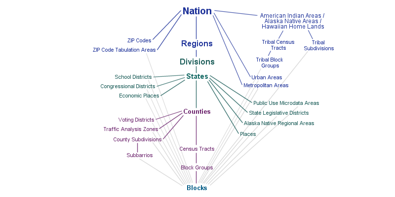
The diagram above shows the relationships between different levels of census geographies. A line between two levels represents a hierarchical relationship between them, meaning that the larger level, generally displayed near the top of the diagram, can be subdivided into a smaller level.
Here’s more information on basic census geographies:
-
States are the primary political (administrative) divisions of the United States of America. The U.S. consists of fifty states, the District of Columbia, Puerto Rico, and other U.S. territories.
-
Counties are the primary political and administrative divisions of states. In the state of Louisiana, however, these divisions are known as parishes. The state of Alaska is another exception, organized into boroughs and census areas. The District of Columbia, which also does not have any county divisions, is considered equivalent to a county for statistical purposes.
-
County Subdivisions fall within counties. Since each state organizes its governments differently, there are some states where the county subdivisions are established legal entities known as Minor Civil Divisions (MCDs). In the rest of the states, county subdivisions are known as Census County Divisions (CCDs) and exist for statistical purposes.
-
Census Tracts are small, relatively permanent statistical subdivisions of a county. In areas where no local participant existed or where local or tribal governments declined to participate, the U.S. Census Bureau delineated census tracts in those areas. The primary purpose of census tracts is to provide a stable set of geographic units for the presentation of decennial census data. Census tracts generally have between 1,500 and 8,000 people, with an optimum size of 4,000 people.
-
Census Block Groups are statistical divisions of census tracts and composed of clusters of census blocks. A census block group consists of all census blocks whose numbers begin with the same digit in a given census tract. Block groups typically contain between 600 and 3,000 people, with an optimum size of 1,500.
-
Census Blocks are the smallest geographic unit for which the Census Bureau collects data. Blocks represent streets, roads, and railroads, bodies of water, and other visible physical and cultural features. Census blocks are numbered uniquely with a four-digit census block number from 0000 to 9999 within census tract which nest within state and county. Census blocks are not delineated based on population.
You can also explore data by ZCTA (zip codes), School Districts (UNSD, SCSD, ELSD), Metropolitan Statistical Areas (MSA), Public Use Microdata Areas (PUMA), Congressional Districts, and many other geographic levels. Head over to this guide for information on these geographic levels.