


| Documentation: | Canadian Census 2011 |
you are here:
choose a survey
survey
document
chapter
Publisher: Statistics Canada
Survey: Canadian Census 2011
| Document: | Statistics Canada - Catalogue no. 98-301-X: 2011 Census Dictionary |
| citation: | Social Explorer; Statistics Canada - Catalogue no. 98-301-X: 2011 Census Dictionary |
Chapter Contents
Statistics Canada - Catalogue no. 98-301-X: 2011 Census Dictionary
The geography universe defines terms related to geographical concepts, infrastructure, products and services. The following summary denotes changes made to the geographic program for the 2011 Census. For further details, refer to the individual definitions of terms.
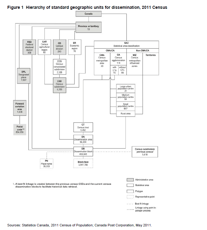
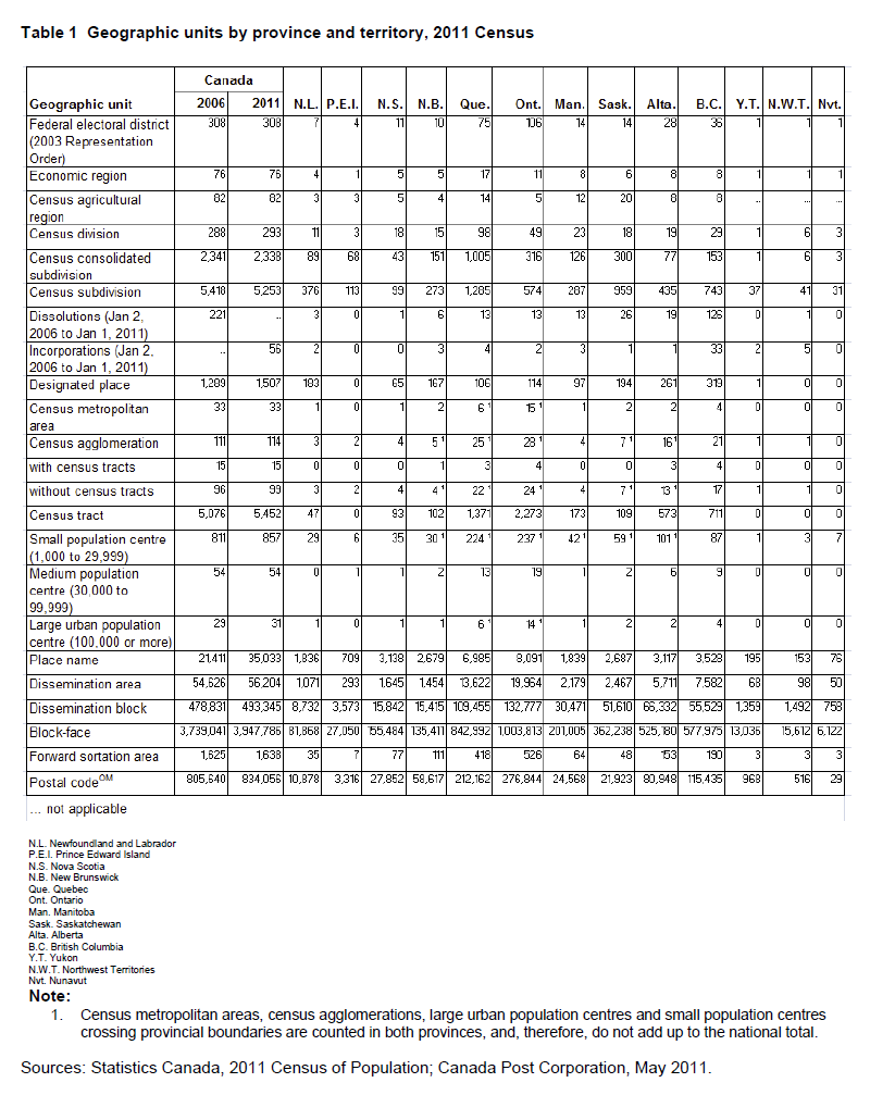
Census data are disseminated for a number of standard geographic areas. These areas are either administrative or statistical. Administrative areas are defined, with a few exceptions, by federal, provincial and territorial statutes. Statistical areas are defined by Statistics Canada as part of the spatial frame for disseminating census data. Figure 1 shows the hierarchy of all standard geographic units for dissemination and Table 1 shows the distribution of geographic units by province and territory.
- Improved coverage and quality of Statistics Canada geographic infrastructure
- The National Geographic Database (NGD) is a joint Statistics Canada/Elections Canada initiative to develop and maintain a national road network file which serves the needs of both organizations. Since 2001, the focus of the NGD has been on improving the quality and currency of its road network coverage using all provincially-sourced data. However, the following provincially/locally-sourced data have been used for geometric realignment: Digital Road Atlas (DRA) in British Columbia and Ontario Road Network (ORN) in six census divisions in Ontario (Halton, Hamilton, Ottawa, Peel, Toronto and Waterloo). Yukon, Northwest Territories and Nunavut now contain territory-sourced data. The result of this effort is a significant expansion of road names, civic address ranges and improved geometric accuracy.
The NGD also contains separate reference layers comprising physical and cultural features such as water features, railway lines and power transmission lines.
These improvements and expansions have been incorporated into Geography Division's Spatial Data Infrastructure (SDI). The result is that users of 2011 Census geography products such as road network files, boundary files and reference maps can geographically reference census data more accurately than before. - Standard geographic areas.
For 2011, the term 'population centre' (POPCTR) replaces the term 'urban area' (UA). A population centre is defined as an area with a population of at least 1,000 and a density of 400 or more persons per square kilometre. All areas outside population centres continue to be defined as rural areas.
Population centres are divided into three groups based on the size of their population to reflect the existence of an urban-rural continuum: - small population centres, with a population of between 1,000 and 29,999
- medium population centres, with a population of between 30,000 and 99,999
- large urban population centres, with a population of 100,000 and over.
Users of the former urban area concept are able to continue with their longitudinal analysis using population centres.
The terms 'core,' 'fringe' and 'rural area' replace the terms 'urban core,' 'urban fringe' and 'rural fringe' for the 2011 Census. Likewise, the term 'secondary core' replaces the term 'secondary urban core.' These terms distinguish between population centres (POPCTRs) and rural areas within a census metropolitan area (CMA) or a census agglomeration (CA).
The 2011 delineation criteria for inclusion in the designated place (DPL) program have changed. The two 2006 delineation criteria which remain are the requirements that the area must be 10 square kilometres or less and that it not overlap the area of a POPCTR.
New for 2011 is the removal of the requirement for a DPL to have a minimum population of 100 and a maximum population of 1,000. As well, there is no longer a requirement for a minimum population density of 150 persons per square kilometre. If, however, the population of the DPL exceeds 1,000 and the population density is at least 400 persons per square kilometre, then the DPL continues to be eligible to become a POPCTR. Population centres that are retired for 2011 due to population decline will still be assessed to determine if they are eligible to be DPLs. Finally, DPLs are no longer required to respect census subdivision (CSD) boundaries. - Adjustment of population counts.
Statistics Canada is committed to protect the privacy of all Canadians and the confidentiality of the data they provide to us. As part of this commitment, some population counts of geographic areas are adjusted in order to ensure confidentiality.
Counts of the total population are rounded to a base of 5 for any dissemination block having a population of less than 15. Population counts for all standard geographic areas above the dissemination block level are derived by summing the adjusted dissemination block counts. The adjustment of dissemination block counts is controlled to ensure that the population counts for dissemination areas will always be within 5 of the actual values. The adjustment has no impact on the population counts of census divisions and large census subdivisions. Population counts of federal electoral districts will be within 5 of the actual values. Dwelling counts are unadjusted.
After a census, Statistics Canada makes public the total number of persons and the total number of dwellings counted in a given area, for example, in a municipality. By the next census, the municipality's geographic boundaries may have changed, especially if it has annexed part of another municipality or has merged with another municipality. When a boundary change occurs between censuses, the population and dwelling counts for the geographic areas affected by the boundary change are revised (adjusted). The adjusted counts show what the counts (the total number of persons and the total number of dwellings) from the previous census would be for the current census boundaries.
'Adjusted counts' refer to previous census population and dwelling counts that were adjusted (i.e., recompiled) to reflect current census boundaries, when a boundary change occurs between the two censuses.
2011, 2006, 2001, 1996, 1991, 1986, 1981, 1976, 1971, 1966, 1961, 1956 (population)
2011, 2006, 2001, 1996 (dwellings)
2011, 2006, 2001, 1996 (dwellings)
When a boundary change occurs, the population and dwellings affected are determined by examining the collection documents from the previous census. The dwellings affected by the boundary change are identified from the collection maps. Once the affected dwellings are identified, it is possible to establish the population affected. These counts are then added to the geographic area that has increased in size and subtracted from the geographic area that has decreased in size.
Boundary changes to standard geographic areas between censuses are generally flagged in census outputs. This is done to warn users doing trend or longitudinal analysis that the areas being compared have changed over time. However, by comparing the final population or dwelling counts from the previous census to the adjusted counts, the user can judge the significance of the boundary change.
In the case of new areas (e.g., census subdivision incorporations), adjusted counts are required to permit the calculation of change. For dissolutions or major boundary changes, the use of adjusted counts instead of the previous census final counts often provides a better measure of trends by removing the effect of the boundary change from the calculation.
Refer to the related definition of census subdivision (CSD).
Category assigned to a municipality not included in either a census metropolitan area (CMA) or a census agglomeration (CA). A municipality within a province is assigned to a census metropolitan influenced zone (MIZ) category depending on the percentage of its resident employed labour force that commute to work in the core of any CMA or CA. A separate category is assigned to the municipalities in the territories that are not part of a CA.
Census subdivisions (CSDs) outside CMAs and CAs are assigned to the following MIZ categories:
Census subdivisions (CSDs) outside CMAs and CAs are assigned to the following MIZ categories:
- Strong metropolitan influenced zone
- Moderate metropolitan influenced zone
- Weak metropolitan influenced zone
- No metropolitan influenced zone
- Territories (outside CAs)
The census metropolitan influenced zone (MIZ) is a concept that geographically differentiates the area of Canada outside census metropolitan areas (CMAs) and census agglomerations (CAs). Census subdivisions (CSDs) within provinces that are outside CMAs and CAs are assigned to one of four categories according to the degree of influence (strong, moderate, weak or no influence) that the CMAs or CAs have on them. CSDs within the territories that are outside CAs are assigned to a separate category.
Census subdivisions within provinces are assigned to a MIZ category based on the percentage of their resident employed labour force that commutes to work in the core(s) of CMAs or CAs. CSDs with the same degree of influence tend to be clustered. They form zones around CMAs and CAs that progress through the categories from 'strong' to 'no' influence as distance from the CMAs and CAs increases. As many CSDs in the territories are very large and sparsely populated, the commuting flow of the resident employed labour force is unstable. For this reason, CSDs in the territories that are outside CAs are assigned to a separate category that is not based on their commuting flows.
CSDs outside CMAs and CAs are assigned to the following MIZ categories:
- Strong metropolitan influenced zone: This category includes CSDs in provinces where at least 30% of the CSD's resident employed labour force commute to work in any CMA or CA. It excludes CSDs with fewer than 40 persons in their resident employed labour force.
- Moderate metropolitan influenced zone: This category includes CSDs in provinces where at least 5% but less than 30% of the CSD's resident employed labour force commute to work in any CMA or CA. It excludes CSDs with fewer than 40 persons in their resident employed labour force.
- Weak metropolitan influenced zone: This category includes CSDs in provinces where more than 0% but less than 5% of the CSD's resident employed labour force commute to work in any CMA or CA. It excludes CSDs with fewer than 40 persons in their resident employed labour force.
- No metropolitan influenced zone: This category includes CSDs in provinces where none of the CSD's resident employed labour force commute to work in any CMA or CA. It also includes CSDs in provinces with fewer than 40 persons in their resident employed labour force.
- Territories (outside CAs): This category includes CSDs in the territories outside CAs.
The MIZ is a concept applied, for statistical analysis purposes, to CSDs outside CMAs and CAs. All CSDs in Canada are either a component of a CMA or a CA or not a component (outside CMAs and CAs). The MIZ provides users with a more detailed geographic identity for the CSDs outside CMAs and CAs. As with CMAs and CAs, the allocation of a CSD to a MIZ category was determined using commuting flows of the resident employed labour force derived from the 2006 Census place of work data.
The calculation of the commuting flows for MIZ differs from the calculation used for CSD inclusion in CMAs or CAs. For the MIZ concept, the percentage of the resident employed labour force living in a particular CSD outside CMAs and CAs and working in the core of any CMA or CA are combined to determine the degree of influence that one or more CMAs or CAs have on that CSD. The resulting percentage then determines the MIZ category assigned to the CSD, as follows:
The calculation of the commuting flows for MIZ differs from the calculation used for CSD inclusion in CMAs or CAs. For the MIZ concept, the percentage of the resident employed labour force living in a particular CSD outside CMAs and CAs and working in the core of any CMA or CA are combined to determine the degree of influence that one or more CMAs or CAs have on that CSD. The resulting percentage then determines the MIZ category assigned to the CSD, as follows:
- Strong metropolitan influenced zone: This category includes CSDs in provinces where a commuting flow of at least 30% of the CSD's resident employed labour force commute to work in any CMA or CA. It excludes CSDs with fewer than 40 persons in their resident employed labour force.
- Moderate metropolitan influenced zone: This category includes CSDs in provinces where at least 5% but less than 30% of the CSD's resident employed labour force commute to work in any CMA or CA. It excludes CSDs with fewer than 40 persons in their resident employed labour force.
- Weak metropolitan influenced zone: This category includes CSDs in provinces where more than 0% but less than 5% of the CSD's resident employed labour force commute to work in any CMA or CA. It excludes CSDs with fewer than 40 persons in their resident employed labour force.
- No metropolitan influenced zone: This category includes CSDs in provinces where none of the CSD's resident employed labour force commute to work in any CMA or CA. It also includes CSDs in provinces with fewer than 40 persons in their resident employed labour force.
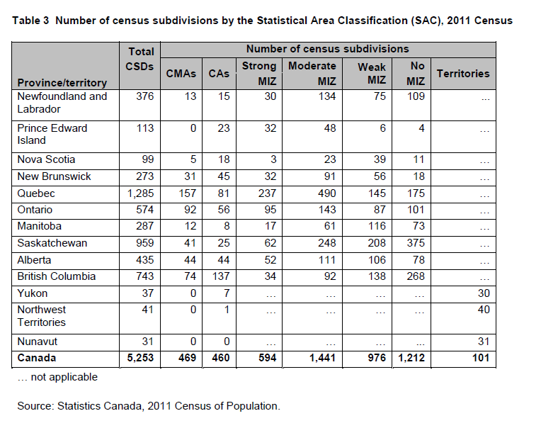
- Territories (outside CAs): This category includes CSDs in the territories outside CAs. Table 3 shows the number of census subdivisions by the Statistical Area Classification (SAC) for Canada, provinces and territories.
Numerical identifier assigned to a geographic area. Every kind of geographic area in Canada has its own type of geographic code. For example, the geographic code assigned to a town makes it possible to distinguish that town from any other towns with the same name that is located in a different province.
A geographic code is a numerical identifier assigned to a geographic area. The code is used to identify and access standard geographic areas for the purposes of data storage, retrieval and display.
Geographic codes are used in combination with the province/territory code and other higher level geographic area codes in order to uniquely identify each geographic unit in Canada.
The Standard Geographical Classification (SGC), Statistics Canada’s official classification of geographic areas, provides unique codes for three hierarchically-related geographic areas: provinces and territories, census divisions and census subdivisions.
For further details, refer to the description of geographic code in the definitions of census agricultural region (CAR); census consolidated subdivision (CCS); census division (CD); census metropolitan area (CMA) and census agglomeration (CA); census subdivision (CSD); census tract (CT); designated place (DPL); dissemination area (DA); dissemination block (DB); economic region (ER); federal electoral district (FED); population centre (POPCTR); province or territory and Standard Geographical Classification (SGC). Also refer to the 2011 Standard Geographical Classification (SGC), Volumes I and II (Catalogue nos. 12-571-X and 12-572-X).
Since 1981, the Standard Geographical Classification has been the sole official geographic classification system used for disseminating data for provinces/territories, census divisions and census subdivisions.
For 1976 and 1971, both the SGC and census codes were used to disseminate census data.
Prior to 1971, only census codes were used to disseminate census data.
For 1976 and 1971, both the SGC and census codes were used to disseminate census data.
Prior to 1971, only census codes were used to disseminate census data.
Number of square kilometres of land in a given geographic area (e.g., a province, a territory, a city).
Land area is the area in square kilometres of the land-based portions of standard geographic areas. Land area data are unofficial and are provided for the sole purpose of calculating population density.
Land area data for the standard geographic areas reflect the boundaries in effect on January 1, 2011 (the geographic reference date for the 2011 Census of Canada). The data are available for all standard geographic areas.
The data are derived from the Spatial Data Infrastructure (SDI), including water polygon layers used in the process for calculating land area. The area calculations are computed from data that are transformed from a Lambert conformal conic projection to an Albers equal-area projection, since the properties of an equal area projection are indispensable for calculating land area. The same projection parameters (two standard parallels, central meridian and latitude of projection origin) are used for each province or territory.
Land area is calculated using ArcGIS® software. There is a two-stage aggregation procedure. First, the data are calculated and stored in square kilometres at the census block (CB)1 level to eight decimal places and then aggregated to the dissemination block (DB) level and rounded to four decimal places. Second, the DB data are individually aggregated to each higher level standard geographic area.
Since the Spatial Data Infrastructure (SDI) is a digital base using three input map scales (1:50,000, 1:250,000 and 1:1,000,000), greater land area accuracy is achieved at larger scales - that is, there is less generalization regarding the symbolization and number of hydrographic features. Land area errors may occur due to digitizing or linkage discrepancies, and when water polygons do not line up or are symbolized differently between different map scales.
The source layer for water has changed in British Columbia for 2011. This may result in varying land area calculations as compared to previous censuses. Users should note that even where the boundaries of standard geographic areas did not change between censuses, the land areas may differ due to geometry shifts. The shifts are caused by a change in the underlying database architecture and by improvements in the absolute positional accuracy of some of the roads.
Refer to related definitions of dissemination block (DB); geographic reference date; population density and Spatial Data Infrastructure (SDI).
For 2006, the data were derived from the Spatial Data Infrastructure (SDI) geospatial layers, including selected water polygons. Land area data were calculated using ArcGIS® software. The data were calculated and stored at the basic block (BB)2 level at eight decimal places and then aggregated to the dissemination block (DB) level and rounded to four decimal places. The DB data were then individually aggregated to all higher level standard geographic areas. Land area data were not disseminated for basic blocks.
For 2001, land area data were calculated using ArcGIS® software. Separate projection parameters (two standard parallels, central meridian and latitude of projection origin) were used for each province or territory. As well, there was only a one-stage aggregation procedure. The data were calculated and stored at the basic block (BB) level at eight decimal places and then aggregated to all higher level geographic areas and rounded to four decimal places. Land area data were not disseminated for basic blocks.
Prior to 2001, land area was manually calculated using a planimeter. Measurements were normally taken three times for each geographic unit and then averaged. The map scales generally varied between 1:50,000 and 1:250,000. In densely and sparsely populated regions of Canada, larger or smaller scales may have been used. Only discernible bodies of water found on the maps were excluded. The planimeter gave accurate readings for only small zones - and consequently, large geographic units were subdivided into smaller ones and measured individually; the individual parts were then added together.
Boundaries that changed from one census to another were not measured in their entirety. Only the land area gained or lost due to a boundary revision/update was measured, and then added to or subtracted from the original figure.
Land area measurements for census subdivisions (CSDs) were aggregated to obtain the land areas for the higher level geographic units - namely, primary census metropolitan areas/primary census agglomerations (PCMAs/PCAs), census metropolitan areas/census agglomerations (CMAs/CAs), census consolidated subdivisions (CCSs), census divisions (CDs), economic regions (ERs), and provinces/territories. Land area measurements were done separately for urban areas (UAs), designated places (DPLs) and census tracts (CTs). Data were not available for enumeration areas (EAs) and federal electoral districts (FEDs).
The land area data were subject to a number of errors, including measurement, coding and transcription, and processing errors - and overall, cumulative historic errors. As well, a limited number of tests revealed logical inconsistencies; for example, there were cases where the land area was greater than the total area.
Prior to 1996, some CSDs had land areas of zero (0) because their official limits were unknown.
For 1991, land area was called 'net land area'.
Prior to 1976, land area data were expressed in square miles only.
1A census block (CB) is an area bounded on all sides by roads and/or boundaries of standard geographic areas. Census blocks cover all the territory of Canada. They are the smallest geographic area for which population and dwelling counts are stored. It must be noted that CBs are not available to the public, but are used internally as the smallest level of geography upon which both collection and dissemination geographies are built.
2The basic block (BB) is the smallest polygon unit in the Spatial Data Infrastructure. BBs are formed by the intersection of all roads and boundary arcs of standard geographic areas that do not follow roads.
2The basic block (BB) is the smallest polygon unit in the Spatial Data Infrastructure. BBs are formed by the intersection of all roads and boundary arcs of standard geographic areas that do not follow roads.
The calculation for population density is total population divided by land area. The data are available for all standard geographic areas.
Population density data support a variety of applications, such as delineating population centres, determining the population ecumene, as well as spatial analysis.
Refer to related definitions of ecumene; land area and population centre (POPCTR).
Population density data support a variety of applications, such as delineating population centres, determining the population ecumene, as well as spatial analysis.
Refer to related definitions of ecumene; land area and population centre (POPCTR).
Prior to 2001, population density data were available for all standard geographic areas, except enumeration areas (EAs) and federal electoral districts (FEDs).
For 1976, population density data were expressed in both square kilometres and square miles.
Prior to 1976, population density data were expressed in square miles only.
For 1976, population density data were expressed in both square kilometres and square miles.
Prior to 1976, population density data were expressed in square miles only.
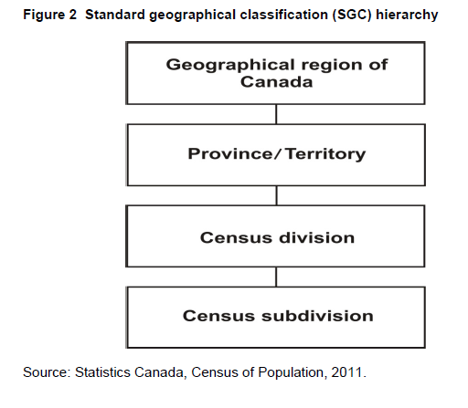
The Standard Geographical Classification (SGC) 2011 is Statistics Canada's main classification of geographic areas in Canada. It is designed to classify statistical information by geographic areas. The classification consists of four levels: geographical regions of Canada, provinces and territories, census divisions (such as counties and regional municipalities) and census subdivisions (such as municipalities). The four geographic levels are hierarchically related; a seven-digit code is used to show this relationship.
The 2011 version of the SGC includes three classification variants:
The 2011 version of the SGC includes three classification variants:
- Statistical Area Classification - Variant of SGC 2011
This classifies census subdivisions by census metropolitan areas (CMAs), census agglomerations (CAs) and census metropolitan influenced zones (MIZ) in the areas outside CMAs and CAs. - Statistical Area Classification by Province and Territory - Variant of SGC 2011This classifies census subdivisions by census metropolitan areas (CMAs), census agglomerations (CAs) and census metropolitan influenced zones (MIZ) in the areas outside CMAs and CAs. In this classification variant, these categories are further classified by provinces and territories.
- Economic Regions - Variant of SGC 2011This classifies census subdivisions into census divisions and economic regions.
Census subdivisions (CSDs) aggregate to census divisions (CDs), which aggregate to province or territory which, in turn, aggregate to geographical regions of Canada (Figure 2).
The hierarchical relationship is reflected in the seven-digit SGC code. For example:
The hierarchical relationship is reflected in the seven-digit SGC code. For example:
| PR-CD-CSD code | Description | |
| 312 06 008 | Province 12: | Nova Scotia |
| CD 06: | Lunenburg | |
| CSD 008: | Mahone Bay | |
| 335 06 008 | Province 35: | Ontario |
| CD 06: | Ottawa | |
| CSD 008: | Ottawa | |
This version introduces structural changes to the classification. It introduces a new level to the standard: geographical regions of Canada. The geographical regions of Canada are:
They represent aggregations of provinces and territories.
The structural change also introduces the new classification variants 'Statistical Area Classification - Variant of SGC 2011' and 'Statistical Area Classification by Province and Territory - Variant of SGC 2011.' These include the census metropolitan areas and census agglomerations and classify the areas of Canada outside CMAs and CAs by census metropolitan influenced zones. Standard terminology has been established for the census metropolitan influenced zones.
The economic regions are now formally recognized as a part of the SGC and are included in the classification variant: 'Economic Regions - Variant of SGC 2011.'
Refer to the related definitions of census division (CD); census metropolitan area (CMA) and census agglomeration (CA); census metropolitan influenced zone (MIZ); census subdivision (CSD); economic region (ER) and province or territory. The Standard Geographical Classification is presented in the 2011 Standard Geographical Classification (SGC), Volumes I and II (Catalogue nos. 12-571-X and 12-572-X).
- Atlantic
- Quebec
- Ontario
- Prairies
- British Columbia
- Territories
They represent aggregations of provinces and territories.
The structural change also introduces the new classification variants 'Statistical Area Classification - Variant of SGC 2011' and 'Statistical Area Classification by Province and Territory - Variant of SGC 2011.' These include the census metropolitan areas and census agglomerations and classify the areas of Canada outside CMAs and CAs by census metropolitan influenced zones. Standard terminology has been established for the census metropolitan influenced zones.
The economic regions are now formally recognized as a part of the SGC and are included in the classification variant: 'Economic Regions - Variant of SGC 2011.'
Refer to the related definitions of census division (CD); census metropolitan area (CMA) and census agglomeration (CA); census metropolitan influenced zone (MIZ); census subdivision (CSD); economic region (ER) and province or territory. The Standard Geographical Classification is presented in the 2011 Standard Geographical Classification (SGC), Volumes I and II (Catalogue nos. 12-571-X and 12-572-X).
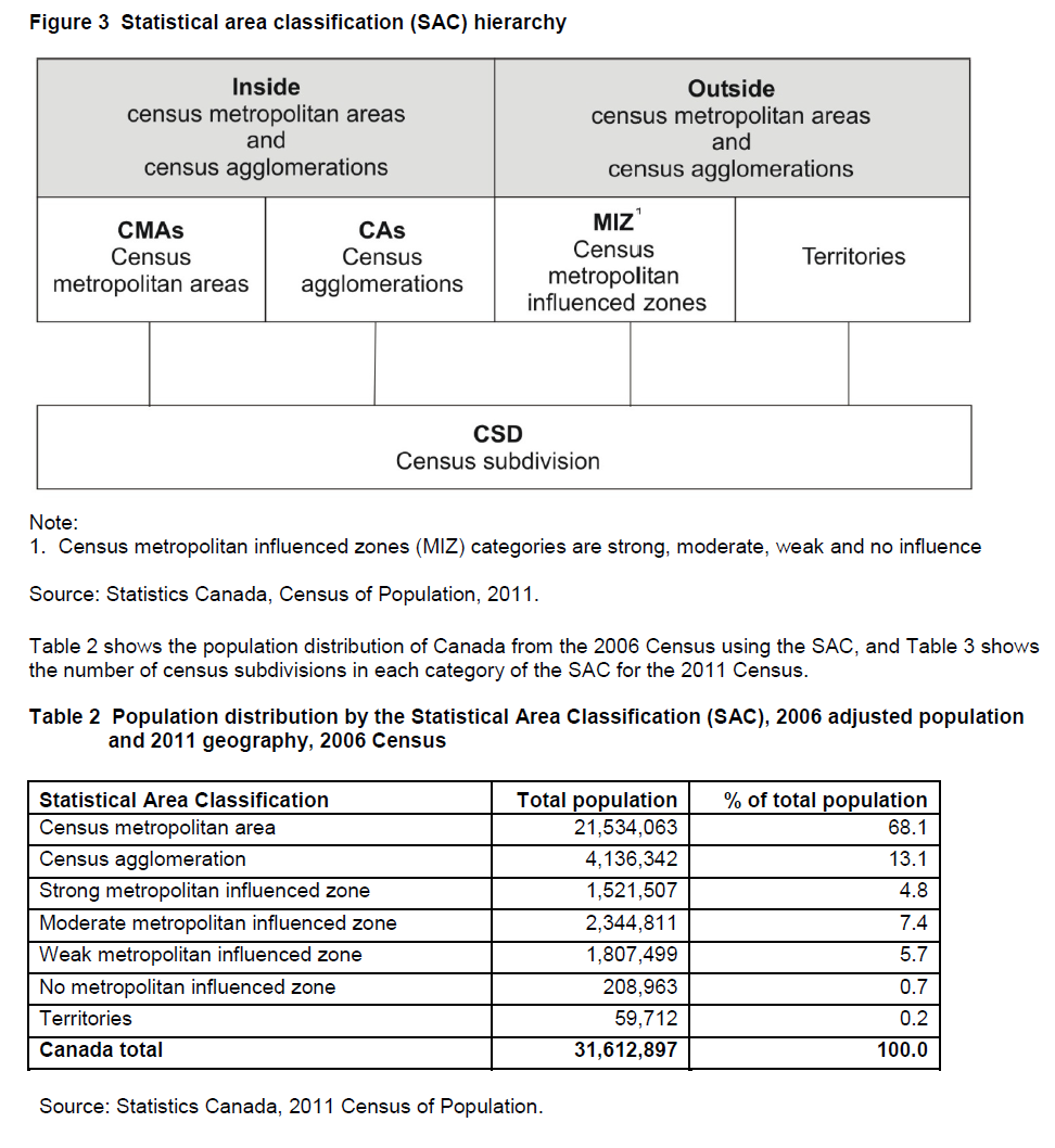
The Statistical Area Classification (SAC) groups census subdivisions according to whether they are a component of a census metropolitan area, a census agglomeration or a census metropolitan influenced zone (MIZ). The MIZ classifies all CSDs in provinces and territories that are outside census metropolitan areas and census agglomerations.
The Statistical Area Classification is a variant of the Standard Geographical Classification (SGC). Census subdivisions (CSDs) form the lowest level of the classification variant. The next level consists of individual census metropolitan areas (CMAs), census agglomerations (CAs) and census metropolitan influenced zones (MIZs).
The highest level consists of three categories that cover all of the land mass of Canada:
- census metropolitan areas
- census agglomerations
- outside census metropolitan areas and census agglomerations.
In using the Statistical Area Classification (SAC) for census data tabulations, it is possible to sum census data automatically for census subdivisions (CSDs) as follows:
Figure 3 shows the hierarchical structure of the SAC.
Refer to the related definitions of census metropolitan area (CMA) and census agglomeration (CA); census metropolitan influenced zone (MIZ); census subdivision (CSD); core, fringe and rural area and to the geographic working paper entitled Census Metropolitan Area and Census Agglomeration Influenced Zones (MIZ): A Description of the Methodology (Catalogue no. 92F0138MIE2000002).
- all CSDs in census metropolitan areas (CMAs)
- all CSDs in census agglomerations (CAs)
- all CSDs in the provinces in the strong metropolitan influenced zone category
- all CSDs in the provinces in the moderate metropolitan influenced zone category
- all CSDs in the provinces in the weak metropolitan influenced zone category
- all CSDs in the provinces in the no metropolitan influenced zone category
- CSDs in the three territories (Yukon, Northwest Territories and Nunavut), except those that are components of a CA (currently the CAs of Whitehorse and Yellowknife).
Figure 3 shows the hierarchical structure of the SAC.
Refer to the related definitions of census metropolitan area (CMA) and census agglomeration (CA); census metropolitan influenced zone (MIZ); census subdivision (CSD); core, fringe and rural area and to the geographic working paper entitled Census Metropolitan Area and Census Agglomeration Influenced Zones (MIZ): A Description of the Methodology (Catalogue no. 92F0138MIE2000002).
Cartographic boundary files (CBFs) contain the boundaries of standard geographic areas together with the shoreline around Canada. Selected inland lakes and rivers are available as supplementary layers.
2011, 2006, 2001 (cartographic boundary files)
1996 (digital cartographic files)
1991, 1986, 1981, 1976 (CARTLIBs)
1996 (digital cartographic files)
1991, 1986, 1981, 1976 (CARTLIBs)
The boundaries of the geographic areas reflect those in effect on January 1, 2011 (the geographic reference date for the 2011 Census of Canada).
Cartographic boundary files are created by integrating Canada’s external shoreline with the selected source boundary layer from the Spatial Data Infrastructure (SDI). The boundaries extending into water bodies are 'erased' and replaced by the shoreline and offshore islands. The hydrographic features are also from the SDI. Further adjustments are made, such as the feature selection and the ranking of features for scale-dependent mapping.
Cartographic boundary files (CBFs) are intended for thematic mapping and analysis purposes. The positional accuracy does not support cadastral, surveying or engineering applications. CBFs can be used in conjunction with road network files (RNFs), since both products are derived from the same sources, and features are generalized in the same manner. The roads in RNFs provide additional geographic context when used with CBFs. CBFs can be used with Census of Population, Census of Agriculture or other Statistics Canada data. Geographic codes provide the linkage between the statistical data and geographic areas.
The maps in Figure 4 below show the differences between cartographic boundary files and digital boundary files.
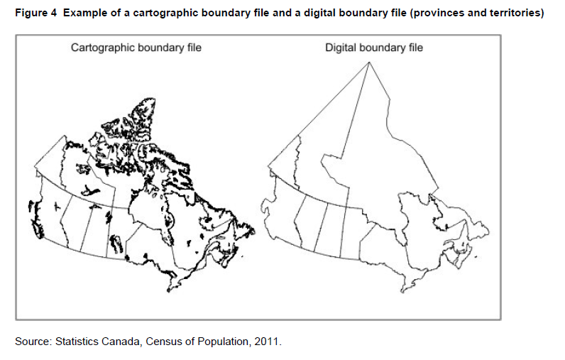
Refer to the related definitions of digital boundary files (DBFs); road network file (RNF); Spatial Data Infrastructure (SDI) and to the Boundary Files, Reference Guide (Catalogue no. 92-160-G).
Cartographic boundary files are created by integrating Canada’s external shoreline with the selected source boundary layer from the Spatial Data Infrastructure (SDI). The boundaries extending into water bodies are 'erased' and replaced by the shoreline and offshore islands. The hydrographic features are also from the SDI. Further adjustments are made, such as the feature selection and the ranking of features for scale-dependent mapping.
Cartographic boundary files (CBFs) are intended for thematic mapping and analysis purposes. The positional accuracy does not support cadastral, surveying or engineering applications. CBFs can be used in conjunction with road network files (RNFs), since both products are derived from the same sources, and features are generalized in the same manner. The roads in RNFs provide additional geographic context when used with CBFs. CBFs can be used with Census of Population, Census of Agriculture or other Statistics Canada data. Geographic codes provide the linkage between the statistical data and geographic areas.
The maps in Figure 4 below show the differences between cartographic boundary files and digital boundary files.
Refer to the related definitions of digital boundary files (DBFs); road network file (RNF); Spatial Data Infrastructure (SDI) and to the Boundary Files, Reference Guide (Catalogue no. 92-160-G).
Digital boundary files (DBFs) portray the boundaries used for Census data collection and, therefore, often extend as straight lines into bodies of water.
The boundaries of the geographic areas reflect those in effect on January 1, 2011 (the geographic reference date for the 2011 Census of Canada).
The boundaries are generated from the Spatial Data Infrastructure (SDI). The boundaries extend into bodies of water, rather than follow the shoreline, to ensure that limits are followed and that all land and islands are included for census enumeration. Thus, boundaries may cut through lakes, extend into oceans, or follow the approximate centres of rivers.
Digital boundary files are not suitable for computing land area, thematic mapping applications or other types of analyses requiring the realistic depiction of shorelines and water bodies, unless the user intends to apply their own shorelines to the boundaries.
Refer to the related definitions of cartographic boundary files (CBFs); road network file (RNF); Spatial Data Infrastructure (SDI) and to the Boundary Files, Reference Guide (Catalogue no. 92-160-G).
The road network file (RNF) contains streets, street names, types, directions and address ranges. Address ranges are dwelling-based.
2011, 2006, 2001 (road network files - cover the entire country)
1996 (street network files - cover large urban centres only)
1991, 1986, 1981, 1976, 1971 (area master files - cover large urban centres only)
1996 (street network files - cover large urban centres only)
1991, 1986, 1981, 1976, 1971 (area master files - cover large urban centres only)
The road network file (RNF) is based on the road network from the Spatial Data Infrastructure (SDI). Statistics Canada maintains the RNF to support the census and other activities. The relative position of road network features is important for census enumeration and reference purposes; therefore, topological accuracy takes precedence over absolute positional accuracy. The RNF does not contain street information required for route optimization. For example, data on one-way streets, dead-ends and other street obstacles are not included in the RNF. Consequently, this file is not recommended for engineering applications, emergency dispatching services, surveying or legal applications.
The road network file contains street arcs with either 'true' address ranges, imputed address ranges, or no address range. Imputed address ranges are not meant to replace true address ranges for any purpose other than address geocoding. Thus, if the files are to be used for computer-aided dispatch or similar purposes (that require an address to be matched to a block or street), it may be necessary to supplement the file with local knowledge by updating existing true addresses and replacing imputed addresses.
The limitations of the road network file should be recognized for uses other than the mapping, analysis and retrieval of census data.
Refer to the related definitions of cartographic boundary files (CBFs); digital boundary files (DBFs); Spatial Data Infrastructure (SDI) and to the Road Network File, Reference Guide (Catalogue no. 92-500-G).
The National Geographic Database (NGD) is a shared database between Statistics Canada and Elections Canada. The database contains roads, road names and address ranges. It also includes separate reference layers containing physical and cultural features, such as hydrography and hydrographic names, railroads and power transmission lines.
The National Geographic Database (NGD) was created in 1997 as a joint Statistics Canada/Elections Canada initiative to develop and maintain a national road network file serving the needs of both organizations. The active building of the NGD (that is, integrating the files from Statistics Canada, Elections Canada and Natural Resources Canada) occurred from 1998 to 2000. Thereafter, Statistics Canada and Elections Canada reconciled their digital boundary holdings to the new database's road network geometry so that operational products could be derived.
Since 2001, the focus of the NGD has been on intensive data quality improvements, especially regarding the quality and currency of its road network coverage. There has been considerable expansion of road names and civic addresses ranges, as well as the addition of hydrographic names.
Since 2009, the NGD has converged its data holdings to provincially-sourced data in all of British Columbia and six census divisions in Ontario, specifically Halton, Hamilton, Ottawa, Peel, Toronto and Waterloo.
Priorities for road network file maintenance are determined by Statistics Canada and Elections Canada, enabling the NGD to meet the joint operational needs of both agencies in support of census and electoral activities.
The main sources for the NGD include:
Since the primary purpose of NGD is to support census and electoral activities, topological accuracy takes precedence over absolute positional accuracy.
The data are maintained and stored in the Lambert conformal conic projection based on the North American Datum of 1983 (NAD83).
Refer to the related definitions of coordinate system; datum; map projection and Spatial Data Infrastructure (SDI).
Since 2001, the focus of the NGD has been on intensive data quality improvements, especially regarding the quality and currency of its road network coverage. There has been considerable expansion of road names and civic addresses ranges, as well as the addition of hydrographic names.
Since 2009, the NGD has converged its data holdings to provincially-sourced data in all of British Columbia and six census divisions in Ontario, specifically Halton, Hamilton, Ottawa, Peel, Toronto and Waterloo.
Priorities for road network file maintenance are determined by Statistics Canada and Elections Canada, enabling the NGD to meet the joint operational needs of both agencies in support of census and electoral activities.
The main sources for the NGD include:
- Statistics Canada's street network files
- Elections Canada's road network file
- National Topographic Database (NTDB) digital coverage at 1:50,000 and 1:250,000 from Natural Resources Canada, and Digital Chart of the World (DCW) coverage at 1:1,000,000
- provincially-sourced data sets
- other information from field operation activities, municipal maps and private sector licenced holdings.
Since the primary purpose of NGD is to support census and electoral activities, topological accuracy takes precedence over absolute positional accuracy.
The data are maintained and stored in the Lambert conformal conic projection based on the North American Datum of 1983 (NAD83).
Refer to the related definitions of coordinate system; datum; map projection and Spatial Data Infrastructure (SDI).
The Spatial Data Infrastructure (SDI) is an internal maintenance database that is not disseminated outside of Statistics Canada. It contains roads, road names and address ranges from the National Geographic Database (NGD), as well as boundary arcs of standard geographic areas that do not follow roads, all in one integrated line layer. The database also includes a related polygon layer consisting of basic bloks (BB)1, boundary layers of standard geographic areas, and derived attribute tables, as well as reference layers containing physical and cultural features (such as hydrography, railroads and power transmission lines) from the NGD.
The SDI supports a wide range of census operations, such as the maintenance and delineation of the boundaries of standard geographic areas (including the automated delineation of dissemination blocks and population centres) and geocoding. The SDI is also the source for generating many geography products for the 2011 Census, such as cartographic boundary files and road network files.
Note
1Basic blocks are the smallest polygon units in the database, and are formed by the intersection of all roads and the arcs of geographic areas that do not follow roads.
The data are maintained and stored in the Lambert conformal conic projection based on the North American Datum of 1983 (NAD83). Links to other data holdings, such as the address register and postal codeOM files, are incorporated into the database.
Given the enhancements to the SDI, primarily through the integration of improved road network data from the National Geographic Database (NGD), geography products for the 2011 Census allow users to geographically reference census data more accurately when compared to the 2006 Census products (e.g., cartographic boundary files, digital boundary files, reference maps, road network files).
Product files from the SDI are available in the Geography Division's data warehouse (GeoDepot).
Refer to the related definitions of block-face; cartographic boundary files (CBFs); coordinate system; datum; digital boundary files (DBFs); dissemination block (DB); geocoding; map projection; National Geographic Database (NGD); reference map; representative point and road network file (RNF), and related reference guides.
See the definition of census metropolitan area (CMA) and census agglomeration (CA).
Census agricultural regions (CARs) are composed of groups of adjacent census divisions. In Saskatchewan, census agricultural regions are made up of groups of adjacent census consolidated subdivisions, but these groups do not necessarily respect census division boundaries.
Census agricultural regions are not defined in Yukon, the Northwest Territories and Nunavut. Also, in Prince Edward Island, for the purpose of disseminating data, each of the three existing census divisions (counties) is treated as a census agricultural region.
In the Prairie Provinces, census agricultural regions are commonly referred to as crop districts.
Each census agricultural region is assigned a two-digit code. In order to uniquely identify each CAR in Canada, the two-digit province/territory (PR) code must precede the CAR code. For example:
Table 1 in the Introduction shows the number of census agricultural regions by province.
Census agricultural regions are used by the Census of Agriculture for disseminating agricultural statistics.
In the Prairie Provinces, census agricultural regions are commonly referred to as crop districts.
Each census agricultural region is assigned a two-digit code. In order to uniquely identify each CAR in Canada, the two-digit province/territory (PR) code must precede the CAR code. For example:
| PR-CAR code | CAR name | |
| 46 03 | Agricultural Region 3 (Man.) | |
| 35 59 03 | Thompson-Okanagan (B.C.) | |
Table 1 in the Introduction shows the number of census agricultural regions by province.
Census agricultural regions are used by the Census of Agriculture for disseminating agricultural statistics.
A census consolidated subdivision (CCS) is a group of adjacent census subdivisions. Generally, the smaller, more densely-populated census subdivisions (towns, villages, etc.) are combined with the surrounding, larger, more rural census subdivision, in order to create a geographic level between the census subdivision and the census division.
Census consolidated subdivisions are defined within census divisions (CDs) according to the following criteria:
The geographic code assigned to each census consolidated subdivision is the seven-digit Standard Geographical Classification (SGC) code of one of its component CSDs, usually the one with the largest land area (Figure 5 shows a hypothetical example). This assignment process also makes the CCS code unique across Canada. For example:
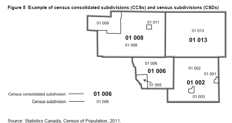
Table 1 in the Introduction shows the number of census consolidated subdivisions by province and territory.
CCSs are used primarily for disseminating Census of Agriculture data. They form the building block for census agricultural regions in Saskatchewan. In all other provinces, census agricultural regions are made up of groups of census divisions.
CCSs are relatively stable geographic units because they have infrequent boundary changes and therefore can be useful for longitudinal analysis.
Refer to the related definitions of census division (CD) and census subdivision (CSD).
- A census subdivision (CSD) with a land area greater than 25 square kilometres can form a CCS of its own. Census subdivisions having a land area smaller than 25 square kilometres are usually grouped with a larger census subdivision.
- A census subdivision with a land area greater than 25 square kilometres and surrounded on more than half its perimeter by another census subdivision is usually included as part of the CCS formed by the surrounding census subdivision.
- A census subdivision with a population greater than 100,000 according to the last census usually forms a CCS on its own.
- The census consolidated subdivision's name usually coincides with its largest census subdivision component in terms of land area.
The geographic code assigned to each census consolidated subdivision is the seven-digit Standard Geographical Classification (SGC) code of one of its component CSDs, usually the one with the largest land area (Figure 5 shows a hypothetical example). This assignment process also makes the CCS code unique across Canada. For example:
| PR-CD-CCS code | Plessisville (Que.) | |
| 35 32 045 | Blandford-Blenheim (Ont.) | |
Table 1 in the Introduction shows the number of census consolidated subdivisions by province and territory.
CCSs are used primarily for disseminating Census of Agriculture data. They form the building block for census agricultural regions in Saskatchewan. In all other provinces, census agricultural regions are made up of groups of census divisions.
CCSs are relatively stable geographic units because they have infrequent boundary changes and therefore can be useful for longitudinal analysis.
Refer to the related definitions of census division (CD) and census subdivision (CSD).
For 1991, significant boundary changes were made to CCSs in Quebec when census divisions were restructured to recognize the municipalités régionales de comté.
For 1976, the term 'census consolidated subdivision' was introduced. Prior to 1976, CCSs were referred to by the term 'reference code.'
For 1976, the term 'census consolidated subdivision' was introduced. Prior to 1976, CCSs were referred to by the term 'reference code.'
Group of neighbouring municipalities joined together for the purposes of regional planning and managing common services (such as police or ambulance services). These groupings are established under laws in effect in certain provinces of Canada. For example, a census division might correspond to a county, une municipalités régionales de comté or a regional district. In other provinces and the territories where laws do not provide for such areas, Statistics Canada defines equivalent areas for statistical reporting purposes in cooperation with these provinces and territories.
Census division (CD) is the general term for provincially legislated areas (such as county, municipalités régionales de comté and regional district) or their equivalents. Census divisions are intermediate geographic areas between the province/territory level and the municipality (census subdivision).
Census divisions have been established in provincial law to facilitate regional planning, as well as the provision of services that can be more effectively delivered on a scale larger than a municipality. In Newfoundland and Labrador, Manitoba, Saskatchewan, Alberta, Yukon, Northwest Territories and Nunavut, provincial or territorial law does not provide for these administrative geographic areas. Therefore, Statistics Canada, in cooperation with these provinces and territories, has created equivalent areas called census divisions for the purpose of disseminating statistical data. In Yukon, the census division is equivalent to the entire territory.
Next to provinces and territories, census divisions are the most stable administrative geographic areas, and are therefore often used in longitudinal analysis.
Next to provinces and territories, census divisions are the most stable administrative geographic areas, and are therefore often used in longitudinal analysis.
Census divisions are classified into 12 types according to official designations adopted by provincial or territorial authorities. Two exceptions are 'census division / division de recensement' (CDR) and 'territory / territoire' (TER), which are geographic units created as equivalents by Statistics Canada, in cooperation with the provinces and territories, for the purpose of disseminating statistical data.
Table 4 shows census division types, their abbreviated forms, and their distribution by province and territory.
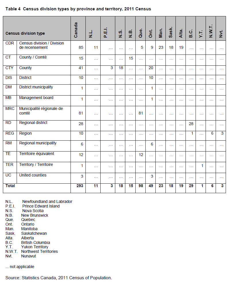
Table 4 shows census division types, their abbreviated forms, and their distribution by province and territory.
The census division (CD) code is a two-digit code that is based on the Standard Geographical Classification (SGC). In order to uniquely identify each CD in Canada, the two-digit province/territory (PR) code must precede the two-digit CD code. For example:
| PR-CD code | CD name | |
| 13 01 | Saint John (N.B.) | |
| 24 01 | Les Îles-de-la-Madeleine (Que.) | |
The following CDs have had name or type changes for the 2011 Census:
(CD 61 01) Region 1, REG (CD 61 02) Region 2, REG (CD 61 03) Region 3, REG (CD 61 04) Region 4, REG (CD 61 05) Region 5, REG (CD 61 06) Region 6, REG The boundaries, names and codes of census divisions reflect those in effect on January 1, 2011, the geographic reference date for the 2011 Census of Canada. Information about any CD changes that were effective on or before the January 1, 2011 reference date must have been received by Statistics Canada prior to March 1, 2011, in order to be processed in time for the census.
Refer to the related definitions of census subdivision (CSD) and Standard Geographical Classification (SGC).
- (CD 24 31) L'Amiante, MRC becomes Les Appalaches, MRC
- (CD 24 40) Asbestos, MRC becomes Les Sources, MRC
- (CD 24 53) Le Bas-Richelieu, MRC becomes Pierre-De Saurel, MRC
- (CD 24 98)
Minganie-Basse-Côte-Nord, CDR becomes Minganie-Le Golfe-du-Saint-Laurent, CDR - (CD 35 10) Frontenac, MB becomes Frontenac, CTY.
Refer to the related definitions of census subdivision (CSD) and Standard Geographical Classification (SGC).
In 2006, the following changes were made to census divisions (CDs).
In New Brunswick, six municipalities (CSDs) straddled the legal county boundaries. In order to maintain the integrity of component municipalities, Statistics Canada modified the CD boundaries to ensure that the CSDs existed completely within the CD. For these six municipalities straddling county boundaries, the county in bold indicates the census division in which these municipalities are completely located:
In Newfoundland and Labrador, Statistics Canada created a new CD in cooperation with the provincial authorities and the Nunatsiavut Government to represent the Labrador Inuit Settlement Area. The lands covered by this new CD, Division No. 11 (CD 10 11), were settled under the Labrador Inuit Land Claims Agreement Act, which was passed and received Royal Assent in December 2004. Five CSDs (Nain, Hopedale, Makkovik, Postville and Rigolet) existed completely within the newly created CD. Two unorganized CSDs (Subdivision C and Subdivision E) were split between the new CD, Division No. 11, and the old CD, Division No. 10.
The CD of Desjardins (CD 24 24) was dissolved. The CSDs of Pintendre, M (24 24 010), Saint-Joseph-de-la-Pointe-de-Lévy, P (24 24 015), and Lévis, V (24 24 020) (now part of CSD Lévis, V [24 25 213]) were annexed to Les Chutes-de-la-Chaudière (now Lévis, TÉ [CD 24 25]) and the CSD of Saint-Henri, M (24 24 005) was annexed to Bellechasse (CD 24 19). The deletion of Desjardins decreased the number of CDs in Quebec to 98.
In Ontario, Frontenac, CTY became Frontenac, MB; Haldimand-Norfolk, RM became Haldimand-Norfolk, CDR; and Brant, CTY became Brant, CDR.
To remain consistent with the conventions used for naming census subdivisions, all CD names had any reference to the associated CD type removed from their names. For example, Niagara Regional Municipality, RM (CD 35 26) became known as Niagara, RM and Perth County, CTY (CD 35 31) became known as Perth, CTY.
In New Brunswick, six municipalities (CSDs) straddled the legal county boundaries. In order to maintain the integrity of component municipalities, Statistics Canada modified the CD boundaries to ensure that the CSDs existed completely within the CD. For these six municipalities straddling county boundaries, the county in bold indicates the census division in which these municipalities are completely located:
- Belledune (Restigouche/Gloucester)
- Fredericton (York/Sunbury)
- Grand Falls / Grand-Sault
- (Victoria/Madawaska)
- Meductic (Carleton/York)
- Minto (Sunbury/Queens)
- Rogersville (Kent/Northumberland)
In Newfoundland and Labrador, Statistics Canada created a new CD in cooperation with the provincial authorities and the Nunatsiavut Government to represent the Labrador Inuit Settlement Area. The lands covered by this new CD, Division No. 11 (CD 10 11), were settled under the Labrador Inuit Land Claims Agreement Act, which was passed and received Royal Assent in December 2004. Five CSDs (Nain, Hopedale, Makkovik, Postville and Rigolet) existed completely within the newly created CD. Two unorganized CSDs (Subdivision C and Subdivision E) were split between the new CD, Division No. 11, and the old CD, Division No. 10.
The CD of Desjardins (CD 24 24) was dissolved. The CSDs of Pintendre, M (24 24 010), Saint-Joseph-de-la-Pointe-de-Lévy, P (24 24 015), and Lévis, V (24 24 020) (now part of CSD Lévis, V [24 25 213]) were annexed to Les Chutes-de-la-Chaudière (now Lévis, TÉ [CD 24 25]) and the CSD of Saint-Henri, M (24 24 005) was annexed to Bellechasse (CD 24 19). The deletion of Desjardins decreased the number of CDs in Quebec to 98.
In Ontario, Frontenac, CTY became Frontenac, MB; Haldimand-Norfolk, RM became Haldimand-Norfolk, CDR; and Brant, CTY became Brant, CDR.
To remain consistent with the conventions used for naming census subdivisions, all CD names had any reference to the associated CD type removed from their names. For example, Niagara Regional Municipality, RM (CD 35 26) became known as Niagara, RM and Perth County, CTY (CD 35 31) became known as Perth, CTY.
Area consisting of one or more neighbouring municipalities situated around a core. A census metropolitan area must have a total population of at least 100,000 of which 50,000 or more live in the core. A census agglomeration must have a core population of at least 10,000.
A census metropolitan area (CMA) or a census agglomeration (CA) is formed by one or more adjacent municipalities centred on a population centre (known as the core). A CMA must have a total population of at least 100,000 of which 50,000 or more must live in the core. A CA must have a core population of at least 10,000. To be included in the CMA or CA, other adjacent municipalities must have a high degree of integration with the core, as measured by commuting flows derived from previous census place of work data.
If the population of the core of a CA declines below 10,000, the CA is retired. However, once an area becomes a CMA, it is retained as a CMA even if its total population declines below 100,000 or the population of its core falls below 50,000. Small population centres with a population count of less than 10,000 are called fringe. All areas inside the CMA or CA that are not population centres are rural areas.
When a CA has a core of at least 50,000, it is subdivided into census tracts. Census tracts are maintained for the CA even if the population of the core subsequently falls below 50,000. All CMAs are subdivided into census tracts.
The terms 'core,' 'fringe' and 'rural area' replace the terms 'urban core,' 'urban fringe' and 'rural fringe' for the 2011 Census.
A census metropolitan area (CMA) or a census agglomeration (CA) can have more than one core. The core of a CMA must have a population of at least 50,000 and the core of a CA must have a population of at least 10,000. In all other cases where a CMA or a CA has more than one core, the additional cores are called secondary cores. When a CA is merged with a CMA, the core of the former CA also becomes a secondary core of the CMA. If the population of a fringe population centre exceeds 10,000, it becomes a secondary core of the CMA or CA in which it exists. See Merging adjacent CMAs and CAs (delineation rule 7).
A CMA or CA is delineated using adjacent municipalities (census subdivisions) as building blocks. These census subdivisions (CSDs) are included in the CMA or CA if they meet at least one of the following rules. The rules are ranked in order of priority. A CSD obeying the rules for two or more CMAs or CAs is included in the one for which it has the highest ranked rule. If the CSD meets rules that have the same rank, the decision is based on the population or the number of commuters involved. A CMA or CA is delineated to ensure spatial contiguity.
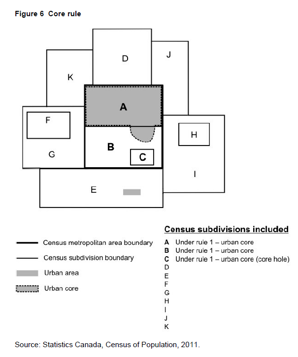
1. Core rule: The CSD falls completely or partly inside the core.
A core hole is a CSD enclosed by a CSD that is at least partly within the urban core and must be included to maintain spatial contiguity. In Figure 6, CSDs A, B and C are included in the CMA or CA because of the core rule. CSD C is a core hole.
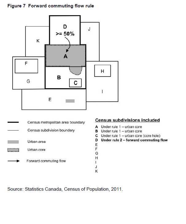
2. Forward commuting flow rule: Given a minimum of 100 commuters, at least 50% of the employed labour force living in the CSD works in the delineation core (see following note), as determined from commuting data based on the place of work question in the previous census.
Note For CMA and CA delineation purposes, a delineation core is created respecting CSD limits. For a CSD to be included in the primary or the secondary delineation core, at least 75% of a CSD's population must reside within the core. In Figure 7, CSD A is part of the delineation core since its entire population resides within the core. CSD B would also be part of the delineation core if at least 75% of its population resides within the core. For this example, we have assumed that less than 75% of the population of CSD B resides within the core; therefore, CSD B and its enclosed hole, CSD C, are not considered to be part of the delineation core.
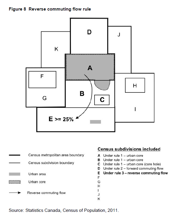
3. Reverse commuting flow rule: Given a minimum of 100 commuters, at least 25% of the employed labour force working in the CSD lives in the delineation core as determined from commuting data based on the place of work question in the previous census. In Figure 8, at least 25% of the employed labour force working in CSD E lives in CSD A (see Note for rule 2).
4. Spatial contiguity rule: CSDs that do not meet a commuting flow threshold may be included in a CMA or CA, and CSDs that do meet a commuting flow threshold may be excluded from a CMA or CA.
Two situations can lead to inclusion or exclusion of a CSD in a CMA or CA for reasons of spatial contiguity. Specifically these are:
Outlier -A CSD (F in Figure 9) with sufficient commuting flows (either forward or reverse) is enclosed by a CSD (G in Figure 9) with insufficient commuting flows, but which is adjacent to the CMA or CA. When this situation arises, the CSDs within and including the enclosing CSD are grouped to create a minimum CSD set (F + G). The total commuting flows for the minimum CSD set are then considered for inclusion in the CMA or CA. If the minimum CSD set has sufficient commuting flows (either forward or reverse), then all of its CSDs are included in the CMA or CA.
Hole - A CSD (H in Figure 9) with insufficient commuting flows (either forward or reverse) is enclosed by a CSD (I in Figure 9) with sufficient commuting flows, and which is adjacent to the CMA or CA. When this situation arises, the CSDs within and including the enclosing CSD are grouped to create a minimum CSD set (H + I). The total commuting flows for the minimum CSD set are then considered for inclusion in the CMA or CA. If the minimum CSD set has sufficient commuting flows (either forward or reverse), then all of its CSDs are included in the CMA or CA.

Notes:
CSD F (outlier) has sufficient flows - either >=50% forward or >=25% reverse commuting flows
CSD G has insufficient flows - has < 50% forward and < 25% reverse commuting flows
CSD H (hole) has insufficient flows - has < 50% forward and < 25% reverse commuting flows
CSD I has sufficient flows - either >=50% forward or >=25% reverse commuting flows
Source: Statistics Canada, Census of Population, 2011.
5. Historical comparability rule: To maintain historical comparability for CMAs and larger CAs (those with census tracts in the previous census), CSDs are retained in the CMA or CA even if their commuting flow percentages fall below the commuting flow thresholds (rules 2 and 3). See Figure 10.

An exception to the historical comparability rule is made in cases where CSDs have undergone changes to their boundaries, such as annexations. To determine whether to keep or exclude a CSD, place of work data are retabulated for the CSD with boundary changes, and a decision to include or exclude the CSD is made according to the previous rules.
6. Manual adjustments: A CMA or CA represents an area that is economically and socially integrated. However, there are certain limitations to the extent by which this ideal can be met. Since the CSDs that are used as building blocks in CMA and CA delineation are administrative units, their boundaries are not always the most suitable with respect to CMA and CA delineation. There are always situations where the application of the above rules creates undesirable outcomes, or where the rules cannot be easily applied. In these circumstances, a manual override is sometimes applied to ensure that the integrity of the program is retained. For example, in Miramichi CA (New Brunswick), the CSD of Red Bank 4, IRI, which is in two parts, is included to maintain spatial contiguity.
7. Merging adjacent CMAs and CAs: A CA adjacent to a CMA can be merged with the CMA if the total percentage commuting interchange between the CA and CMA is equal to at least 35% of the employed labour force living in the CA, based on place of work data from the previous census. The total percentage commuting interchange is the sum of the commuting flow in both directions between the CMA and the CA as a percentage of the labour force living in the CA (i.e., resident employed labour force.
1. Core rule: The CSD falls completely or partly inside the core.
A core hole is a CSD enclosed by a CSD that is at least partly within the urban core and must be included to maintain spatial contiguity. In Figure 6, CSDs A, B and C are included in the CMA or CA because of the core rule. CSD C is a core hole.
2. Forward commuting flow rule: Given a minimum of 100 commuters, at least 50% of the employed labour force living in the CSD works in the delineation core (see following note), as determined from commuting data based on the place of work question in the previous census.
Note For CMA and CA delineation purposes, a delineation core is created respecting CSD limits. For a CSD to be included in the primary or the secondary delineation core, at least 75% of a CSD's population must reside within the core. In Figure 7, CSD A is part of the delineation core since its entire population resides within the core. CSD B would also be part of the delineation core if at least 75% of its population resides within the core. For this example, we have assumed that less than 75% of the population of CSD B resides within the core; therefore, CSD B and its enclosed hole, CSD C, are not considered to be part of the delineation core.
3. Reverse commuting flow rule: Given a minimum of 100 commuters, at least 25% of the employed labour force working in the CSD lives in the delineation core as determined from commuting data based on the place of work question in the previous census. In Figure 8, at least 25% of the employed labour force working in CSD E lives in CSD A (see Note for rule 2).
4. Spatial contiguity rule: CSDs that do not meet a commuting flow threshold may be included in a CMA or CA, and CSDs that do meet a commuting flow threshold may be excluded from a CMA or CA.
Two situations can lead to inclusion or exclusion of a CSD in a CMA or CA for reasons of spatial contiguity. Specifically these are:
Outlier -A CSD (F in Figure 9) with sufficient commuting flows (either forward or reverse) is enclosed by a CSD (G in Figure 9) with insufficient commuting flows, but which is adjacent to the CMA or CA. When this situation arises, the CSDs within and including the enclosing CSD are grouped to create a minimum CSD set (F + G). The total commuting flows for the minimum CSD set are then considered for inclusion in the CMA or CA. If the minimum CSD set has sufficient commuting flows (either forward or reverse), then all of its CSDs are included in the CMA or CA.
Hole - A CSD (H in Figure 9) with insufficient commuting flows (either forward or reverse) is enclosed by a CSD (I in Figure 9) with sufficient commuting flows, and which is adjacent to the CMA or CA. When this situation arises, the CSDs within and including the enclosing CSD are grouped to create a minimum CSD set (H + I). The total commuting flows for the minimum CSD set are then considered for inclusion in the CMA or CA. If the minimum CSD set has sufficient commuting flows (either forward or reverse), then all of its CSDs are included in the CMA or CA.
Notes:
CSD F (outlier) has sufficient flows - either >=50% forward or >=25% reverse commuting flows
CSD G has insufficient flows - has < 50% forward and < 25% reverse commuting flows
CSD H (hole) has insufficient flows - has < 50% forward and < 25% reverse commuting flows
CSD I has sufficient flows - either >=50% forward or >=25% reverse commuting flows
Source: Statistics Canada, Census of Population, 2011.
5. Historical comparability rule: To maintain historical comparability for CMAs and larger CAs (those with census tracts in the previous census), CSDs are retained in the CMA or CA even if their commuting flow percentages fall below the commuting flow thresholds (rules 2 and 3). See Figure 10.
An exception to the historical comparability rule is made in cases where CSDs have undergone changes to their boundaries, such as annexations. To determine whether to keep or exclude a CSD, place of work data are retabulated for the CSD with boundary changes, and a decision to include or exclude the CSD is made according to the previous rules.
6. Manual adjustments: A CMA or CA represents an area that is economically and socially integrated. However, there are certain limitations to the extent by which this ideal can be met. Since the CSDs that are used as building blocks in CMA and CA delineation are administrative units, their boundaries are not always the most suitable with respect to CMA and CA delineation. There are always situations where the application of the above rules creates undesirable outcomes, or where the rules cannot be easily applied. In these circumstances, a manual override is sometimes applied to ensure that the integrity of the program is retained. For example, in Miramichi CA (New Brunswick), the CSD of Red Bank 4, IRI, which is in two parts, is included to maintain spatial contiguity.
7. Merging adjacent CMAs and CAs: A CA adjacent to a CMA can be merged with the CMA if the total percentage commuting interchange between the CA and CMA is equal to at least 35% of the employed labour force living in the CA, based on place of work data from the previous census. The total percentage commuting interchange is the sum of the commuting flow in both directions between the CMA and the CA as a percentage of the labour force living in the CA (i.e., resident employed labour force.
Each CMA and CA is assigned a three-digit code that identifies it uniquely in Canada. The first digit is the same as the second digit of the province code in which the CMA or CA is located. If a CMA or CA spans a provincial boundary, then the province code assigned represents the province with the greater proportion of core population. Codes for CAs in Yukon and the Northwest Territories begin with the same digit as for those CMAs or CAs located in British Columbia. There are currently no CMAs or CAs in Nunavut.
The key revision to the convention is the establishment of 'Guidelines for CMA name change requests' as published in Preliminary 2011 Census Metropolitan and Census Agglomeration Delineation (Catalogue no. 92F0138M). Below are the guidelines for requesting a change:
1. CMA names can consist of up to three legislated municipal names of eligible census subdivisions (CSDs) that are components of the CMA. However, the number of name elements in any new CMA name request is limited to five. If any of the eligible CSD names are already hyphenated or compound, the number of CSD names will be limited to two or one if the number of name elements exceeds five.
2. The eligible municipal names include the historic central municipality name and the two component CSDs with the largest population, and having a population of at least 10,000, according to the last census.
3. The ordering of the municipal names within the CMA name is determined by the historic (central) municipality and the population size of the eligible CSDs. The first component of the CMA name is always the historic (central) CSD even if its census population count is less than the other eligible component CSDs. This ensures that CMA names retain a measure of stability for better longitudinal recognition. The second and third place name order is determined by population size. The component CSD with the higher census population count at the time of the name change assumes the second position and the next largest component CSD, the third position.
4. In order for a requested CMA name change to be implemented, there must be explicit consensus among all eligible component municipalities on a proposed new name and a formal request, in accordance with these guidelines, must be sent to the Director of the Geography Division at Statistics Canada by June 1 of the year prior to the census. The CMA name change will be implemented in the revision of the Standard Geographical Classification related to the census under consideration.
5. Statistics Canada will continue to change CMA names whenever the legislated name of a municipality changes. Any other request for a name change will only be considered within the context of these guidelines.
Total resident employed labour force living in the CA and working in the CMA + Total resident employed labour force living in the CMA and working in the CA X 100%
/
Resident employed labour force of the CA
If more than one CA is adjacent to the same CMA, each CA is assessed separately with the CMA. Several CAs may be merged with one CMA. If the total percentage commuting interchange is less than 35%, the CMA and CA are not merged.
After a CA is merged with a CMA, the core of the former CA is called the secondary core of the CMA. See Figure 11.
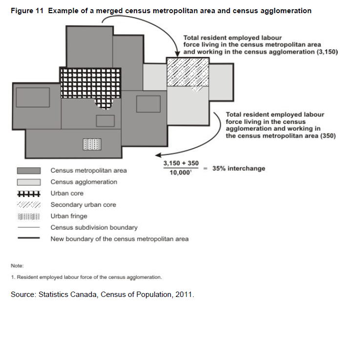
Prior to May 25, 2009, the convention for the naming of a CMA or CA was based on the name of the principal population centre or largest city at the time the CMA or CA was first formed. This standard had been used since the 1971 Census. Through the years, the CMA and CA names have remained stable. The most important changes resulted from name changes to the census subdivisions (resulting from municipal dissolutions, incorporations and name changes).
Table 1 in the Introduction shows the number of census metropolitan areas and census agglomerations by province and territory.
| CMA/CA code | |
| 215 | |
| 995 | |
| 24 505 | |
| 47 840 |
Table 1 in the Introduction shows the number of census metropolitan areas and census agglomerations by province and territory.
Two CMAs from the previous census had their names changed: Abbotsford became Abbotsford-Mission (B.C.) and Kitchener became Kitchener-Cambridge-Waterloo (Ont.).
Five new CAs were created: Steinbach (Man.), High River (Alta.), Strathmore (Alta.), Sylvan Lake (Alta.) and Lacombe (Alta.).
The CAs of La Tuque (Que.) and Kitimat (B.C.) were retired because the population of their cores dropped below 10,000 in 2006.
Five new CAs were created: Steinbach (Man.), High River (Alta.), Strathmore (Alta.), Sylvan Lake (Alta.) and Lacombe (Alta.).
The CAs of La Tuque (Que.) and Kitimat (B.C.) were retired because the population of their cores dropped below 10,000 in 2006.
CMAs and CAs are statistically comparable because they are delineated in the same way across Canada. They differ from other areas such as trading or marketing areas, or regional planning areas designated by regional authorities for planning and other purposes, and should be used with caution for non-statistical purposes.
The CSD limits used in CMA and CA delineation are those in effect on January 1, 2011 (the geographic reference date for the 2011 Census) and received by Statistics Canada before March 1, 2011. In addition, CMA and CA delineation uses commuting data based on the place of work question asked in the previous census.
Refer to the related definitions of census subdivision (CSD); core, fringe and rural area; population centre (POPCTR) and to the geography working paper Preliminary 2011 Census Metropolitan Area and Census Agglomeration Delineation (Catalogue no. 92F0138MWE2009002).
2006 - For 2006, CAs were no longer required to have an urban core population of 100,000 to be promoted to the status of a CMA. Instead, CAs assumed the status of a CMA if they had attained a total population of at least 100,000 of which 50,000 or more lived in the urban core.
- Prior to the 2011 Census, CMA and CA delineation used commuting data based on the place of work question asked in the decennial census. The 2006 CMAs and CAs are based on the population and place of work data from the 2001 Census while the 2001 and 1996 CMAs and CAs are based on population and place of work data from the 1991 Census.
2001 - For 2001, CAs were required to have an urban core population of at least 100,000 to be changed to the status of a CMA.
- For 2001, consolidated CMAs were no longer defined for dissemination purposes. As a result, primary CMAs and primary CAs were also not defined. However, the consolidation rule was retained and incorporated into the CMA delineation methodology. There was no substantive change to the methodology for defining CMAs and no change to the limits of CMAs resulting from this rule change.
- Prior to 2001, adjacent CMAs and CAs that had sufficient commuting interchange (35% or more) and were merged were identified by the terms 'primary census metropolitan area (PCMA)' and 'primary census agglomeration (PCA)'. The terms 'consolidated census metropolitan area' (CCMA) and 'consolidated census agglomeration' (CCA) described the sum of the component CMAs and CAs. Census data were disseminated for these areas. These terms were not used for the standard dissemination program for 2001.
- Six of 27 CMAs were affected significantly as a result of municipal restructuring: Halifax (N.S.), Ottawa - Hull (Ont./Que.), Kingston (Ont.), Greater Sudbury (Ont.), London (Ont.) and Windsor (Ont.).
1996 - Two changes to CMA/CA delineation rules were implemented to preserve data comparability over time. CMAs could be consolidated with CAs, but they could not be consolidated with other CMAs. A primary census agglomeration (PCA) could not be retired from a consolidated CMA or CA (with census tracts at the previous census) even if its total commuting interchange percentage dropped below the consolidation threshold of 35%. Exceptions to this rule could occur due to changes in the physical structure of the urban areas used to determine the urban cores.
- Minimum sets of CSDs were used instead of the census consolidated subdivisions (CCSs) for evaluation in the spatial contiguity rule. Refer to the spatial contiguity rule (rule 4).
1986 - Introduction of the consolidated and primary CMA and CA concept.
- The forward commuting threshold was raised from 40% to 50% to control for differences in processing of the place of work data between 1971 and 1981.
- Introduction of the minimum of 100 commuters for forward and reverse commuting for both CMAs and CAs. Single CSD (component) CAs were permitted.
1981 - Commuting data based on the place of work question of the previous decennial census were used for the first time to delineate CAs. For both CMAs and CAs, the forward commuting threshold was 40% and the reverse commuting threshold was 25%.
The minimum urbanized core population for CAs was raised from 2,000 to 10,000.
CAs were eligible for census tracts if they had a CSD with a population of at least 50,000 at the time of the previous census. Single CSD (component) CAs could be created for subdivision into census tracts.
1976 - Commuting data based on the place of work question of the previous decennial census were used for the first time to delineate CMAs. The forward commuting threshold was 40% and the reverse commuting threshold was 25% for the CMAs.
For CAs, see 1971.
1971 - CMAs were defined as main labour market areas, but were delineated according to alternate criteria based on the labour force composition, population growth rate and accessibility. At this time, the CMA of Saint John, N.B. was 'grandfathered'.
CAs were comprised of at least two adjacent municipal entities. These entities had to be at least partly urban and belong to an urbanized core having a population of at least 2,000. The urbanized core included a largest city and a remainder, each with a population of at least 1,000, and had a population density of at least 1,000 per square mile (386 persons per square kilometre).
1966 - See 1961.
1961 - CMAs were delineated around cities with a population of at least 50,000, if the population density and labour force composition criteria were met, and the total CMA population was at least 100,000.
CAs were called major urban areas; see 1951.
1956 - See 1951.
1951 - The term 'census metropolitan area' appeared for the first time. This term designated cities of over 50,000 having fringe municipalities in close geographic, economic and social relations, the whole constituting a unit of over 100,000.
The concept of 'major urban areas', the forerunners to CAs, was introduced. The term designated urban areas in which the largest city had a population of at least 25,000 and fewer than 50,000.
1941 - Data were published for 'greater cities', i.e., those cities which have well-defined satellite communities in close economic relationship to them.
Area that is a municipality or an area that is deemed to be equivalent to a municipality for statistical reporting purposes (e.g., as an Indian reserve or an unorganized territory). Municipal status is defined by laws in effect in each province and territory in Canada.
Census subdivision (CSD) is the general term for municipalities (as determined by provincial/territorial legislation) or areas treated as municipal equivalents for statistical purposes (e.g., Indian reserves, Indian settlements and unorganized territories).
Census subdivisions (CSDs) are classified into 54 types according to official designations adopted by provincial/territorial or federal authorities. Two exceptions are 'subdivision of unorganized' (SNO) in Newfoundland and Labrador, and 'subdivision of county municipality' (SC) in Nova Scotia, which are geographic areas created as equivalents for municipalities by Statistics Canada, in cooperation with those provinces, for the purpose of disseminating statistical data.
The census subdivision type accompanies the census subdivision name in order to distinguish CSDs from each other, for example, Balmoral, VL (for the village of Balmoral) and Balmoral, P (for the parish / paroisse (municipalité de) of Balmoral).
Changes to CSD types for 2011 include the following:
1. CSD types added
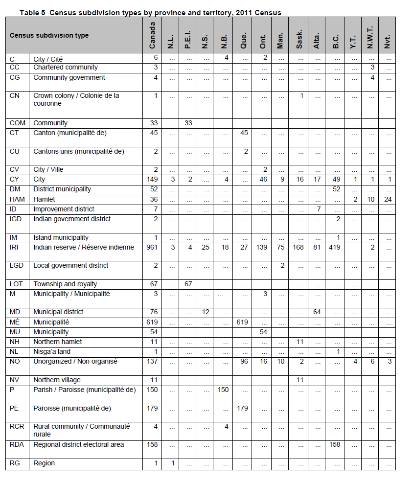
- City / Ville (CV) in Ontario
- Self-government / Autonomie gouvernementale (SG) in Yukon
- Cité (CÉ) was replaced by Ville (V) in Quebec
- County (municipality) (CM) was corrected to Municipal district (MD) in Alberta
- Nisga'a village (NVL) has been included in Nisga'a land (NL) in British Columbia
On reserve population is a derived census variable that is captured by using the census subdivision (CSD) type according to criteria established by Aboriginal Affairs and Northern Development Canada (AANDC; formerly Indian and Northern Affairs Canada [INAC]). On reserve population includes people living in any of the six CSD types legally affiliated with First Nations or Indian bands (described below), as well as the northern village of Sandy Bay in Saskatchewan.
The following census subdivision types are based on the legal definition of communities affiliated with First Nations or Indian bands.
The following census subdivision types are based on the legal definition of communities affiliated with First Nations or Indian bands.
- Indian reserve (IRI) - A tract of federally owned land with specific boundaries that is set apart for the use and benefit of an Indian band and that is governed by Aboriginal Affairs and Northern Development Canada (AANDC).Statistics Canada only recognizes the subset of Indian reserves that are populated (or potentially populated) as census subdivisions. For 2011, of the more than 3,100 Indian reserves across Canada, there are 961 Indian reserves classified as CSDs (including the 6 reserves added for 2011). Statistics Canada works closely with AANDC to identify those reserves to be added as CSDs.
- Indian settlement (S-É) - A place where a self-contained group of at least 10 Indian (Aboriginal) persons resides more or less permanently. It is usually located on Crown lands under federal or provincial/territorial jurisdiction. Indian settlements have no official limits and have not been set apart for the use and benefit of an Indian band as is the case with Indian reserves. Statistics Canada relies on AANDC to identify Indian settlements to be recognized as census subdivisions, and their inclusion must be with the agreement of the provincial or territorial authorities. An arbitrary boundary is delineated to represent each Indian settlement as a census subdivision. (Exclusions: Champagne Landing 10, Klukshu, Two and One-Half Mile Village, Two Mile Village and Kloo Lake which have CSD type S-É are excluded from this tabulation.)
- Indian government district (IGD) - Sechelt reserve lands in British Columbia. The Sechelt Indian Band Self-Government Act is a transfer by Her Majesty in right of Canada to the Sechelt Band in all Sechelt reserve lands, recognizing that the Sechelt Band would assume complete responsibility for the management, administration and control of all Sechelt lands. The Sechelt Indian Government District Enabling Act (British Columbia) recognizes the district Council as the governing body of the Sechelt Indian Government District. The district Council may enact laws or by-laws that a municipality has power to enact under an Act of the province.
- Terres réservées aux Cris (TC) - Parcels of land in Quebec set aside for the permanent residence of Cree First Nations of Quebec. Terres réservées aux Cris are adjacent to villages cris. The area of a village cri is set aside for the use of Cree bands, but members of Cree bands are not permanently residing there. Note that a village cri and its adjacent terre réservée aux Cris can have the same name, e.g., the village cri of Waswanipi and the terre reservée aux Cris of Waswanipi.
- Terres réservées aux Naskapis (TK) - Parcels of land in Quebec set aside for the permanent residence of Naskapi First Nations of Quebec. Terres réservées aux Naskapis are adjacent to village Naskapi. The lone area of village Naskapi is set aside for the use of the Naskapi band, although its members do not reside there permanently.
- Nisga'a land (NL) - Part of the territory whose title has been transferred to the Nisga'a Nation by the Final Land Claims Agreement of 1998 between the Nisga'a Nation, the Government of Canada and the Government of British Columbia. Together with the four Nisga'a villages (NVL), this territory makes up the Nisga'a Lands defined by the land claims agreement.
The census subdivision (CSD) code is a three-digit code that is based on the Standard Geographical Classification (SGC). In order to uniquely identify each CSD in Canada, the two-digit province/territory (PR) code and the two-digit census division (CD) code must precede the CSD code. For example:
There are two municipalities in Canada that straddle provincial limits: Flin Flon (Manitoba and Saskatchewan) and Lloydminster (Saskatchewan and Alberta). Each of their provincial parts is treated as a separate CSD. Indian reserves are also treated as separate CSDs when they straddle provincial limits.
| PR-CD-CSD code | CSD name and type | |
| 12 06 008 | Mahone Bay, T (N.S.) | |
| 35 06 008 | Ottawa, CV (Ont.) | |
There are two municipalities in Canada that straddle provincial limits: Flin Flon (Manitoba and Saskatchewan) and Lloydminster (Saskatchewan and Alberta). Each of their provincial parts is treated as a separate CSD. Indian reserves are also treated as separate CSDs when they straddle provincial limits.
The following reserve CSDs were deleted because they are not to be populated.
The boundaries, names, codes and status of census subdivisions reflect those in effect on January 1, 2011, the geographic reference date for the 2011 Census of Canada. Information about any CSD changes that were effective on or before the January 1, 2011 reference date must have been received by Statistics Canada prior to March 1, 2011, in order to be processed in time for the census.
Refer to the related definition of Standard Geographical Classification (SGC) and to the 2011 Standard Geographical Classification (SGC), Volume I (Catalogue no. 12-571-X) for summaries of the intercensal census subdivision changes to codes, names and status.
- Summerside 38 (1214024) in Nova Scotia
- Red Bank 7 (1309025) and St. Mary's 24 (1310035) in New Brunswick
- Whitworth (2412802), Cacouna (2412804) and Coucoucache (2490801) in Quebec
- Naiscoutaing 17A (3549079), Zhiibaahaasing 19 (Cockburn Island 19) (3551035), Whitefish River (Part) 4 (3552017), Mountbatten 76A (3552055), New Post 69 (3556104), Missanabie 62 (3557082), Lake Of The Woods 31G (3560062), Wunnumin 2 (3560072), Wapekeka 1 (3560074) and Sachigo Lake 2 (3560087) in Ontario
- Reed River 36A (4601096), Long Plain (Part) 6 (4608039), Cross Lake 19B (4622053), Cross Lake 19C (4622054), Nelson House 170A (4622060), Nelson House 170B (4622061), Nelson House 170C (4622062) and Highrock 199 (4623063) in Manitoba
- Makwa Lake 129A (4717814), Thunderchild First Nation 115D (4717818), Stanley 157A (4718804), ÃŽle-Ã -la-Crosse 192E (4718805), Dipper Rapids 192C (4718816), Primeau Lake 192F (4718830), Turnor Lake 194 (4718837), Clearwater River Dene Band 221 (4718838), Elak Dase 192A (4718843) and Fond du Lac 233 (4718848) in Saskatchewan
- Clearwater 175 (4816823), Devil's Gate 220 (4816825), Chipewyan 201 (4816828), Chipewyan 201B (4816834), Chipewyan 201C (4816837), Chipewyan 201D (4816840), Chipewyan 201E (4816843), Chipewyan 201F (4816845), Chipewyan 201G (4816848), Sandy Point 221 (4816851), Cornwall Lake 224 (4816853) and Collin Lake 223 (4816854) in Alberta
- Bummers Flat 6 (5901807), Aywawwis 15 (5909801), Boothroyd 5A (5909802), Boothroyd 8A (Part) (5909803), Ruby Creek 2 (5909811), Sho-ook 5 (5909813), Chaumox 11 (5909820), Swahliseah 14 (5909840), Franks 10 (5909846), Samahquam 1 (5909865), Kuthlalth 3 (5909870), Mayne Island 6 (5917806), Pacheena 1 (5917816), Claoose 4 (5919805), Lyacksun 3 (5919810), Wyah 3 (5919819), Openit 27 (5923812), Stuart Bay 6 (5923815), Keeshan 9 (5923821), Nuchatl 2 (5925808), Nuchatl 1 (5925809), Aupe 6 (5925815), Aupe 6A (5925816), Tatpo-oose 10 (5925819), Matsayno 5 (5925825), Saaiyouck 6 (5925830), Harwood Island 2 (5927805), Chekwelp 26A (5929802), Schaltuuch 27 (5929804), Seton Lake 5A (5931830), Slosh 1A (5931839), Hamilton Creek 7 (5933804), Leon Creek 2 (5933835), Spatsum 11 (5933847), Papyum 27A (5933856), Siska Flat 5A (5933862), Siska Flat 5B (5933863), Staiyahanny 8 (5933869), Cameron Bar 13 (5933890), Andy Cahoose Meadow 16 (5941824), Baezaeko River 25 (5941825), Cahoose 8 (5941826), Baezaeko River 26 (5941836), Tsunnia Lake 5 (5941853), Casimiel Meadows 15A (5941857), Kushya Creek 7 (5941867), Quattishe 1 (5943805), Karlukwees 1 (5943810), Apsagayu 1A (5943820), Compton Island 6 (5943824), Mahmalillikullah 1 (5943828), Glen-Gla-Ouch 5 (5943832), Gitzault 24 (5949831), Tsay Cho 4 (5951808), Kuz Che 5 (5951816), Bihl'k'a 18 (5951817), Isaac (Gale Lake) 8 (5951835), Maxan Lake 4 (5951837), Bihlk'a 6 (5951842) and Parsnip 5 (5953804) in British Columbia.
- Alert Bay 1 (5943801) and Alert Bay 1A (5943802) to Alert Bay (5943837)
- Alexandria 1 (5941815), Alexandria 1A (5941870), Alexandria 3 (5941816) and Alexandria 3A (5941814) to Alexandria (5941882)
- Anahim's Meadow 2 (5941822) and Anahim's Meadow 2A (5941823) to Anahim's Meadow (5941883)
- Chuchhriaschin 5 (5933816) and Chuchhriaschin 5A (5933822) to Chuchhriaschin (5933810)
- Cowichan 1 (5919807) and Cowichan 9 (5919806) to Cowichan (5919822)
- Garden 2 (5941830) and Garden 2A (5941832) to Garden (5941884)
- Halhalaeden 14 (5933818) and Halhalaeden 14A (5933815) to Halhalaeden (5933813)
- Inkluckcheen 21 (5933820) and Inkluckcheen 21B (5933894) to Inkluckcheen (5933833)
- Kanaka Bar 1A (5933826) and Kanaka Bar 2 (5933827) to Kanaka Bar (5933882)
- Little Springs 8 (5941874) and Little Springs 18 (5941875) to Little Springs (5941885)
- Mount Currie 1 (5931803), Mount Currie 2 (5931811), Mount Currie 6 (5931838), Mount Currie 8 (5931837) and Mount Currie 10 (5931804) to Mount Currie (5931843)
- Nanaimo River 2 (5921802), Nanaimo River 3 (5921801) and Nanaimo River 4 (5921803) to Nanaimo River (5921807)
- Nequatque 1 (5931805), Nequatque 2 (5931840) and Nequatque 3A (5931810) to Nequatque (5931844)
- Neskonlith 1 (Neskainlith 1) (5933883) and Neskonlith 2 (5933885) to Neskonlith (5933838)
- North Tacla Lake 7 (5951812) and North Tacla Lake 7A (5951841) to North Tacla Lake (5951848)
- Sachteen 2 (5909855) and Sachteen 2A (5909860) to Sachteen (5909883)
- Siska Flat 3 (5933860) and Siska Flat 8 (5933864) to Siska Flat (5933849)
- Skowkale 10 (5909822) and Skowkale 11 (5909823) to Skowkale (5909884)
- Spences Bridge 4 (5933867) and Spences Bridge 4C (5933871) to Spences Bridge (5933881)
- Squiaala 7 (5909828) and Squiaala 8 (5909829) to Squiaala (5909885)
- Switsemalph 6 (5939809) and Switsemalph 7 (5939810) to Switsemalph (5939811)
- Telegraph Creek 6 (5949826) and Telegraph Creek 6A (5949827) to Telegraph Creek (5949847)
- T'Sou-ke 1 (Sooke 1) (5917817) and T'Sou-ke 2 (Sooke 2) (5917818) to T'Sou-ke (5917819)
- Aiyansh (Kitladamas) 1, NVL (5949836); Gingolx, NVL (5949842); Gitwinksihlkw, NVL (5949838); Laxgalts'ap, NVL (5949840) and New Aiyansh, NVL (5949834) to Nisga'a, NL (5949035).
The boundaries, names, codes and status of census subdivisions reflect those in effect on January 1, 2011, the geographic reference date for the 2011 Census of Canada. Information about any CSD changes that were effective on or before the January 1, 2011 reference date must have been received by Statistics Canada prior to March 1, 2011, in order to be processed in time for the census.
Refer to the related definition of Standard Geographical Classification (SGC) and to the 2011 Standard Geographical Classification (SGC), Volume I (Catalogue no. 12-571-X) for summaries of the intercensal census subdivision changes to codes, names and status.
Municipal restructuring between 2001 and 2006 resulted in two noteworthy provinces: Quebec, with 282 dissolutions and 100 incorporations, and Saskatchewan, with 29 dissolutions and 11 incorporations.
The following census subdivisions had their Standard Geographical Classification code revised:
Newfoundland and Labrador: due to the creation of a new census division, Division No. 11, to represent the Inuit Settlement Area; see related census division definition.
The following census subdivisions had their Standard Geographical Classification code revised:
Newfoundland and Labrador: due to the creation of a new census division, Division No. 11, to represent the Inuit Settlement Area; see related census division definition.
- Rigolet, T - 1010021 to 1011010
- Postville, T - 1010059 to 1011015
- Makkovik, T - 1010044 to 1011020
- Hopedale, T - 1010048 to 1011030
- Nain, T - 1010056 to 1011035
- Charette, MÉ - 2436005 to 2451080
- Saint-Boniface-de-Shawinigan, VL - 2436020 to Saint-Boniface, MÉ - 2451085
- Saint-Élie, PE - 2436010 to Saint-Élie-de-Caxton, MÉ - 2451075
- Saint-Étienne-des-Grés, PE - 2437080 to 2451090
- Saint-Henri, MÉ - 2424005 to 2419068
- Saint-Lambert-de-Lauzon, PE - 2425005 to 2426070
- Saint-Mathieu-du-Parc, MÉ - 2436015 to 2451070
- Waterville, V - 2443005 to 2444080
- Batiscan, MÉ - 2437025 to 2437210
- Champlain, MÉ - 2437030 to 2437220
- Notre-Dame-du-Mont-Carmel, PE - 2436040 to 2437235
- Saint-Luc-de-Vincennes, MÉ - 2437035 to 2437225
- Saint-Maurice, PE - 2437045 to 2437230
- Saint-Narcisse, PE - 2437040 to 2437240
- Saint-Prosper, PE - 2437010 to 2437250
- Saint-Stanislas, MÉ - 2437015 to 2437245
- Sainte-Anne-de-la-Pérade, MÉ - 2437005 to 2437205
- Sainte-Geneviève-de-Batiscan, PE - 2437020 to 2437215
- Petit-Saguenay, MÉ - 2494005 to 2494205
- L'Anse-Saint-Jean, MÉ - 2494010 to 2494210
- Riviére-Éternité, MÉ - 2494015 to 2494215
- Ferland-et-Boilleau, MÉ - 2494020 to 2494220
- Saint-Félix-d'Otis, MÉ - 2494025 to 2494225
- Sainte-Rose-du-Nord, PE - 2494030 to 2494230
- Saint-Fulgence, MÉ - 2494035 to 2494235
- Saint-Honoré, MÉ - 2494060 to 2494240
- Larouche, MÉ - 2494080 to 2494265
- Saint-Charles-de-Bourget, MÉ - 2494085 to 2494260
- Saint-Ambroise, MÉ - 2494090 to 2494255
- Saint-David-de-Falardeau, MÉ - 2494095 to 2494245
- Bégin, MÉ - 2494100 to 2494250
- Lalemant, NO - 2494902 to 2494926
- Lac-Ministuk, NO - 2494904 to 2494928
- Mont Valin, NO - 2494906 to 2494930
'Census subdivision - previous census' refers to the census subdivisions as of January 1, 2006, the geographic reference date for the 2006 Census. A 'best fit' linkage is established between dissemination blocks for the 2011 Census and census subdivisions (municipalities) for the 2006 Census. This linkage ensures that data from the current census can be tabulated for the census subdivisions from the previous census.
The boundaries and names of census subdivisions (municipalities) can change from one census to the next because of annexations, dissolutions and incorporations. These changes can result in fewer, larger census subdivisions and historical data analyses becoming more complex. The concept of 'census subdivision - previous census' was established to provide a means of tabulating current census data according to census subdivisions as they were delineated for the previous census.
Census data are tabulated for standard geographic areas by aggregating the data for individual dissemination blocks. Dissemination blocks respect the boundaries of census subdivisions for the current census (2011 Census) but do not necessarily respect the boundaries of census subdivisions for the previous census (2006 Census). In order to facilitate the tabulation of 2011 Census data for the census subdivisions (CSDs) as they existed for the 2006 Census, the 2011 dissemination block representative points are overlaid onto the previous census CSD boundaries. The goal is to ensure that at least one dissemination block is linked to each previous census CSD. In a few cases, there is not an exact match-that is, some dissemination blocks straddle two or more CSDs from the previous census, but can only be linked to one CSD. For these cases, a 'best fit' approach is used to ensure that the representative point for at least one dissemination block is linked to every previous census CSD. Thus, reasonably accurate tabulations of 2011 Census data can be produced for the census subdivisions as of January 1, 2006, the geographic reference date for the 2006 Census.
Refer to the related definitions of census subdivision (CSD); dissemination block (DB); geographic reference date and representative point.
Area that is small and relatively stable. Census tracts usually have a population between 2,500 and 8,000 persons. They are located in census metropolitan areas and in census agglomerations that have a core population of 50,000 or more.
Census tracts (CTs) are small, relatively stable geographic areas that usually have a population between 2,500 and 8,000 persons. They are located in census metropolitan areas and in census agglomerations that had a core population of 50,000 or more in the previous census.
A committee of local specialists (for example, planners, health and social workers, and educators) initially delineates census tracts in conjunction with Statistics Canada. Once a census metropolitan area (CMA) or census agglomeration (CA) has been subdivided into census tracts, the census tracts are maintained even if the core population subsequently declines below 50,000.
A committee of local specialists (for example, planners, health and social workers, and educators) initially delineates census tracts in conjunction with Statistics Canada. Once a census metropolitan area (CMA) or census agglomeration (CA) has been subdivided into census tracts, the census tracts are maintained even if the core population subsequently declines below 50,000.
Rules are used to delineate census tracts. The initial delineation rules are ranked in the order of the following priorities:
Changes to census tract boundaries are discouraged in order to maintain maximum data comparability between censuses. Boundary revisions rarely occur, and only when essential. Road construction, railroad abandonment, community redevelopment, neighbourhood growth and municipal annexations may contribute to changes in census tract boundaries. A census tract may be split into two or more new census tracts (usually when its population exceeds 8,000). CT splits are usually done in a way that allows users to re-aggregate the splits to the original census tract for historical comparison.
The minimum population of 2,500 allows for statistically significant data tabulations. The maximum population of 8,000 facilitates delineation and retention of relatively homogeneous and useful tracts. The population range and average also permit data comparability among census tracts.
- Census tract (CT) boundaries must follow permanent and easily recognizable physical features. However, street extensions, utility or transportation easements, property lines and municipal limits may be used as CT boundaries if physical features are not in close proximity or do not exist.
- The population of a CT should range between 2,500 and 8,000, with a preferred average of 4,000. CTs in the central business district, major commercial and industrial zones, or peripheral areas can have populations outside this range.
- The CT should be as homogeneous as possible in terms of socioeconomic characteristics, such as similar economic status and social living conditions at the time of its creation.
- The CT's shape should be as compact as possible.
- CT boundaries respect census metropolitan area, census agglomeration and provincial boundaries. However, CT boundaries do not necessarily respect census subdivision (municipality) boundaries.
Changes to census tract boundaries are discouraged in order to maintain maximum data comparability between censuses. Boundary revisions rarely occur, and only when essential. Road construction, railroad abandonment, community redevelopment, neighbourhood growth and municipal annexations may contribute to changes in census tract boundaries. A census tract may be split into two or more new census tracts (usually when its population exceeds 8,000). CT splits are usually done in a way that allows users to re-aggregate the splits to the original census tract for historical comparison.
The minimum population of 2,500 allows for statistically significant data tabulations. The maximum population of 8,000 facilitates delineation and retention of relatively homogeneous and useful tracts. The population range and average also permit data comparability among census tracts.
Each census tract is assigned a seven-character numeric 'name' (including leading zeros, the decimal point and trailing zeros). To uniquely identify each census tract in its corresponding census metropolitan area (CMA) or tracted census agglomeration (CA), the three-digit CMA/CA code must precede the CT 'name'. For example:
Census tract naming is consistent from census to census to facilitate historical comparability.
When a CA enters the census tract program, the census subdivision (CSD) that gives the CA its name is assigned the first CT 'name', starting at 0001.00. When all of the CTs within the first CSD are named, then the CTs of the adjoining CSDs are named, and finally those on the periphery are named.
If a census tract is split into two or more parts due to a population increase, the number after the decimal point identifies the splits. For example, CT 0042.00 becomes CT 0042.01 and CT 0042.02. If CT 0042.01 is subsequently split, it becomes CT 0042.03 and CT 0042.04. Similarly, if CT 0042.02 is split after CT 0042.01, it becomes CT 0042.05 and CT 0042.06. Any splits occurring after this would be numbered in a similar fashion, with the next sequential number.
This allows users to re-aggregate the splits to the original census tract.
Table 1 in the Introduction shows the number of census tracts by province and territory.
A conversion table showing the relationship between the current and previous census tracts for each tracted centre is available upon request from the Geography Division, Statistics Canada.
The nature of the census tract concept, along with the availability of a wide range of census data, makes census tracts useful in many applications. These include:
Refer to the related definition of census metropolitan area (CMA) and census agglomeration (CA).
| CMA/CA code - CT name | CMA/CA name | |
| 562 0005.00 | Sarnia CA (Ont.) | |
| 933 0005.00 | Vancouver CMA (B.C.) | |
Census tract naming is consistent from census to census to facilitate historical comparability.
When a CA enters the census tract program, the census subdivision (CSD) that gives the CA its name is assigned the first CT 'name', starting at 0001.00. When all of the CTs within the first CSD are named, then the CTs of the adjoining CSDs are named, and finally those on the periphery are named.
If a census tract is split into two or more parts due to a population increase, the number after the decimal point identifies the splits. For example, CT 0042.00 becomes CT 0042.01 and CT 0042.02. If CT 0042.01 is subsequently split, it becomes CT 0042.03 and CT 0042.04. Similarly, if CT 0042.02 is split after CT 0042.01, it becomes CT 0042.05 and CT 0042.06. Any splits occurring after this would be numbered in a similar fashion, with the next sequential number.
This allows users to re-aggregate the splits to the original census tract.
Table 1 in the Introduction shows the number of census tracts by province and territory.
A conversion table showing the relationship between the current and previous census tracts for each tracted centre is available upon request from the Geography Division, Statistics Canada.
The nature of the census tract concept, along with the availability of a wide range of census data, makes census tracts useful in many applications. These include:
- municipal and regional planning and research, such as the development, evaluation and revision of official plans
- educational and research studies in high schools, community colleges and universities
- market research, such as identifying areas of opportunity and evaluating market or service potential for housing, health, educational, recreational or retailing facilities.
Refer to the related definition of census metropolitan area (CMA) and census agglomeration (CA).
Beginning in 1996, census agglomerations were eligible for census tracts based on the population size of their urban cores (50,000 or more at the previous census). This was a change from previous censuses, when census agglomerations had to contain a municipality (census subdivision) with a population of 50,000 or more at the previous census to be eligible for census tracts.
From 1971 to 1991, a provincial census tract program existed. Provincial census tracts were similar in concept to census tracts, but covered areas outside census metropolitan areas and census agglomerations. Taken together, census tracts and provincial census tracts covered all of Canada.
In 1941 and 1946, census tracts were called 'social areas.'
The terms 'core,' 'fringe' and 'rural area' replace the terms 'urban core,' 'urban fringe' and 'rural fringe' for the 2011 Census. These terms distinguish between population centres (POPCTRs) and rural areas (RAs) within a census metropolitan area (CMA) or census agglomeration (CA).
A CMA or CA can have two types of cores: the core and the secondary core. The core is the population centre with the highest population, around which a CMA or a CA is delineated. The core must have a population (based on the previous census) of at least 50,000 persons in the case of a CMA, or at least 10,000 persons in the case of a CA.
The secondary core is a population centre within a CMA that has at least 10,000 persons and was the core of a CA that has been merged with an adjacent CMA.
The term 'fringe' includes all population centres within a CMA or CA that have less than 10,000 persons and are not contiguous with the core or secondary core.
All territory within a CMA or CA that is not classified as a core or fringe is classified as rural area.
While every CMA and CA has a core, it may or may not have a secondary core, a fringe or a rural area. See Figure 12.
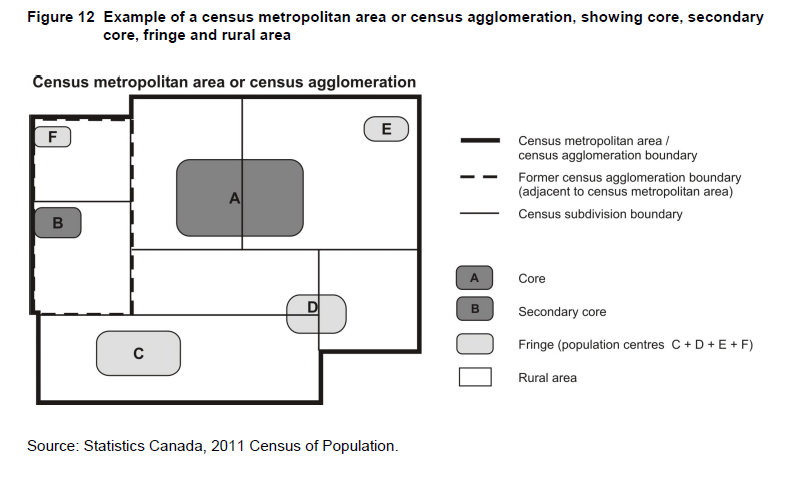
Population counts for population centres are published according to the class of population centre, regardless of whether they are inside or outside of a CMA or CA. Population centres are classified into one of three groups, depending on the size of their population:
Population counts for population centres are published according to the class of population centre, regardless of whether they are inside or outside of a CMA or CA. Population centres are classified into one of three groups, depending on the size of their population:
- small population centres, with a population between 1,000 and 29,999
- medium population centres, with a population between 30,000 and 99,999
- large urban population centres, with a population of 100,000 or more.
Prior to 2011, the terms 'urban core,' 'secondary urban core,' 'urban fringe' and 'rural fringe' were used.
Beginning in 2001, the concept of the secondary urban core was used to describe the urban core of a CA that merged with an adjacent CMA.
Beginning in 1996, the term 'urban core' replaced the term 'urbanized core.' The term 'urbanized core' was used from 1971 to 1991.
Prior to 1996, this concept was known as CMA/CA parts.
Beginning in 1986, primary CMAs (PCMAs) and primary CAs (PCAs) were delineated within some CMAs and CAs. Because of this change, some urban areas that were urban fringes of 1981 CMAs or CAs became urban cores of 1986 PCMAs or PCAs.
For 1976 and 1971, the urbanized core was further broken down into the 'largest city' and 'remainder.'
For 1966 and 1961, the urban part of the CMA was divided into the 'metropolitan area - urban' (continuous built-up area) and the 'metropolitan area - outside urban' (non-continuous built-up area); the remaining rural part was known as 'metropolitan area - rural.'
Usually a small community that does not meet the criteria used to define municipalities or population centres (areas with a population of at least 1,000 and no fewer than 400 persons per square kilometre). Designated places are created by provinces and territories in cooperation with Statistics Canada.
A designated place (DPL) is normally a small community or settlement that does not meet the criteria established by Statistics Canada to be a census subdivision (an area with municipal status) or a population centre.
Designated places are created by provinces and territories, in cooperation with Statistics Canada, to provide data for submunicipal areas.
Designated places are created by provinces and territories, in cooperation with Statistics Canada, to provide data for submunicipal areas.
The criteria that small communities or settlements must meet in order to become a designated place (DPL) include:
Those 2006 urban areas which no longer meet the criteria to be included in the 2011 population centre program will be considered for inclusion in the designated place program for 2011. Furthermore, designated places will not be permitted to overlap population centres.
For 2011, the DPL of Cowichan 1 (DPL 59 0321) in British Columbia overlaps the POPCTR of Duncan (POPCTR 0243). In an effort to minimize data suppression for this area, this DPL represents a formerly discontiguous Aboriginal community which has been combined to form a single discontiguous census subdivision (CSD).
Designated places are no longer required to respect census subdivision boundaries. Where a designated place straddles one or more census subdivision limits, DPL parts will be created.
The areas recognized as designated places may not represent all places having the same status within a province or territory.
Table 1 in the Introduction shows the number of designated places by province and territory.
Table 6 shows the types of designated places, their abbreviated forms and their distribution by province and territory.

Each designated place is assigned a four-digit code. In order to uniquely identify each DPL in Canada, the two-digit province/territory (PR) code must precede the DPL code. For example:
Refer to the related definitions of census subdivision (CSD); place name (PN); population centre (POPCTR) and rural area (RA).
- an area less than or equal to 10 square kilometres
- a boundary that respects the block structure from the previous census, where possible
- an area that does not overlap the area of a population centre.
Those 2006 urban areas which no longer meet the criteria to be included in the 2011 population centre program will be considered for inclusion in the designated place program for 2011. Furthermore, designated places will not be permitted to overlap population centres.
For 2011, the DPL of Cowichan 1 (DPL 59 0321) in British Columbia overlaps the POPCTR of Duncan (POPCTR 0243). In an effort to minimize data suppression for this area, this DPL represents a formerly discontiguous Aboriginal community which has been combined to form a single discontiguous census subdivision (CSD).
Designated places are no longer required to respect census subdivision boundaries. Where a designated place straddles one or more census subdivision limits, DPL parts will be created.
The areas recognized as designated places may not represent all places having the same status within a province or territory.
Table 1 in the Introduction shows the number of designated places by province and territory.
Table 6 shows the types of designated places, their abbreviated forms and their distribution by province and territory.
Each designated place is assigned a four-digit code. In order to uniquely identify each DPL in Canada, the two-digit province/territory (PR) code must precede the DPL code. For example:
| PR code | DPL code | |
| 13 | 0085 | |
Refer to the related definitions of census subdivision (CSD); place name (PN); population centre (POPCTR) and rural area (RA).
In 2006, the criteria that small communities were required to respect in order to become a DPL included:
In 2001 and earlier, designated places were not required to respect census subdivision (CSD) boundaries. As a result, a number of DPLs straddled two or more CSDs. To identify these DPLs and the CSDs that they straddled, the seven-digit SGC code (PR-CD-CSD) had to precede the DPL code. The DPL part flag identified the number of parts the DPL is divided into as a result of straddling CSDs.
In 1996, Statistics Canada introduced the concept of designated places as a new geographic unit for data dissemination to respond to the increasing demand for population counts and census data according to 'submunicipal' or unincorporated areas. The concept generally applied to small communities for which there may have been some level of legislation, but they fell below the criteria established for municipal status.
Between 1981 and 1991, Statistics Canada had facilitated the retrieval of census data by delineating these submunicipal areas at the enumeration area level only. The number of areas delineated expanded from fewer than 50 northern communities in Manitoba in 1981, to more than 800 areas across Canada by 1996.
- a minimum population of 100 and a maximum population of 1,000. The maximum population limit may have been exceeded provided that the population density was less than 400 persons per square kilometre, which was the population density that defined an urban area
- a population density of 150 persons or more per square kilometre
- an area less than or equal to 10 square kilometres
- a boundary that respected the block structure from the previous census, where possible
- a boundary that respected census subdivision (CSD) limits.
In 2001 and earlier, designated places were not required to respect census subdivision (CSD) boundaries. As a result, a number of DPLs straddled two or more CSDs. To identify these DPLs and the CSDs that they straddled, the seven-digit SGC code (PR-CD-CSD) had to precede the DPL code. The DPL part flag identified the number of parts the DPL is divided into as a result of straddling CSDs.
In 1996, Statistics Canada introduced the concept of designated places as a new geographic unit for data dissemination to respond to the increasing demand for population counts and census data according to 'submunicipal' or unincorporated areas. The concept generally applied to small communities for which there may have been some level of legislation, but they fell below the criteria established for municipal status.
Between 1981 and 1991, Statistics Canada had facilitated the retrieval of census data by delineating these submunicipal areas at the enumeration area level only. The number of areas delineated expanded from fewer than 50 northern communities in Manitoba in 1981, to more than 800 areas across Canada by 1996.
Small area composed of one or more neighbouring dissemination blocks, with a population of 400 to 700 persons. All of Canada is divided into dissemination areas.
A dissemination area (DA) is a small, relatively stable geographic unit composed of one or more adjacent dissemination blocks. It is the smallest standard geographic area for which all census data are disseminated. DAs cover all the territory of Canada.
For 2011, dissemination areas (DAs) were defined as needed, rather than being completely re-delineated. This was to help ensure the comparability of data since the previous census. To do this, planners located in areas with census tracts were surveyed for their input regarding the delineation of DAs that experienced high population growth between the 2001 and 2006 Censuses or that exceeded the DA maximum population limit. Other user-defined DA updates were accepted in areas where the DA structure either changed substantially between 2001 and 2006 as a result of automated delineation or simply did not provide users (local area experts) with relevant data since the DAs were not representative of their communities. The implementation of both of these types of user-defined updates eliminated the requirement for a fully automated delineation, which was used in previous censuses.
Dissemination areas respect several delineation criteria designed to maximize their usefulness for data analysis and to meet operational constraints.
- Dissemination area (DA) boundaries respect the boundaries of census subdivisions and census tracts. DAs therefore remain stable over time, to the extent that census subdivisions and census tracts do.
- Dissemination area boundaries follow roads. DA boundaries may follow other features (such as railways, water features, power transmission lines), where these features form part of the boundaries of census subdivisions or census tracts.
- Dissemination areas are uniform in terms of population size, which is targeted from 400 to 700 persons to avoid data suppression. DAs with lower population counts (including zero population) may result in order to respect the boundaries of census subdivisions and census tracts. DAs with higher population counts may also result.
- Dissemination areas are delineated based on the block population counts from the previous census due to operational constraints.
- Dissemination areas are compact in shape, to the extent possible while respecting the above criteria.
- The number of dissemination blocks that are included in a dissemination area is limited to 99 due to operational constraints.
Each dissemination area (DA) is assigned a four-digit code. In order to uniquely identify each DA in Canada, the two-digit province/territory (PR) code and the two-digit CD code must precede the DA code. For example:
When dissemination areas were first created, geographic proximity was embedded in the DA code by assigning DA codes in a serpentine manner within each census division. As DAs evolve, this coding structure cannot be maintained.
Therefore, DA codes can no longer ensure geographic proximity.
Table 1 in the Introduction shows the number of dissemination areas by province and territory.
Refer to the related definitions of census subdivision (CSD); census tract (CT) and dissemination block (DB).
| PR-CD-CSD code | Description | |
| 12 09 0103 | Province 12: | Nova Scotia |
| CD 09: | Halifax | |
| DA 0103 | ||
| 59 09 0103 | Province 59: | British Columbia |
| CD 09: | Fraser Valley | |
| DA 0103 | ||
When dissemination areas were first created, geographic proximity was embedded in the DA code by assigning DA codes in a serpentine manner within each census division. As DAs evolve, this coding structure cannot be maintained.
Therefore, DA codes can no longer ensure geographic proximity.
Table 1 in the Introduction shows the number of dissemination areas by province and territory.
Refer to the related definitions of census subdivision (CSD); census tract (CT) and dissemination block (DB).
In 2006, dissemination areas (DAs) were delineated outside of census metropolitan areas (CMAs) and census agglomerations (CAs) using an automated area delineation system. Within CMAs and CAs that contained census tracts (CTs), DAs were kept relatively stable since the previous census. Some DAs in these areas were adjusted to respect changes to CT, CA, and CMA boundaries.
In 2001, the DA was a new standard geographic area. It replaced the enumeration area (EA) as a basic unit for dissemination. The 1996 population counts were used to delineate the DAs, mainly in block-face geocoding areas of CMAs and those CAs that contained CTs. Everywhere else, the 2001 DAs were the same as the 2001 EAs used for data collection.
In 2001, the DA was a new standard geographic area. It replaced the enumeration area (EA) as a basic unit for dissemination. The 1996 population counts were used to delineate the DAs, mainly in block-face geocoding areas of CMAs and those CAs that contained CTs. Everywhere else, the 2001 DAs were the same as the 2001 EAs used for data collection.
Area equivalent to a city block bounded by intersecting streets. These areas cover all of Canada.
A dissemination block (DB) is an area bounded on all sides by roads and/or boundaries of standard geographic areas. The dissemination block is the smallest geographic area for which population and dwelling counts are disseminated.
Dissemination blocks cover all the territory of Canada.
Dissemination blocks cover all the territory of Canada.
Dissemination blocks are primarily an artefact of the road network. As such, the number of DBs created is a function of the timeliness and accuracy of the road network prior to the census. It is not possible to have a road network reflecting exactly the situation on Census Day. For the 2011 Census, the road network used for DB creation is up-to-date as of fall 2010.
Highway medians, ramp areas and other irregular polygons may form dissemination blocks on their own. A morphological dissemination block is split to form two or more DBs wherever it is traversed by the boundaries of selected standard geographic areas, namely federal electoral districts (FEDs), census subdivisions (CSDs), census tracts (CTs), designated places (DPLs) or dissemination areas (DAs). This makes it possible to aggregate dissemination block data to all standard geographic areas.
In rural areas where the road network is sparse or even non-existent, the boundaries of collection units are used to avoid creating very large dissemination blocks.
Each dissemination block is assigned a two-digit code. In order to uniquely identify each dissemination block in Canada, the two-digit province/territory (PR) code, the two-digit census division (CD) code and the four-digit dissemination area (DA) code must precede the DB code. For example:
Only population and dwelling counts are disseminated at the dissemination block level (with the dissemination area being the smallest standard geographic area for which characteristic data are disseminated). To ensure confidentiality, population counts are adjusted for dissemination blocks having a population of less than 15.
Table 1 in the Introduction shows the number of dissemination blocks by province and territory.
Refer to the related definitions of census division (CD); census subdivision (CSD); census tract (CT); designated place (DPL); dissemination area (DA); federal electoral district (FED) and Spatial Data Infrastructure (SDI).
Highway medians, ramp areas and other irregular polygons may form dissemination blocks on their own. A morphological dissemination block is split to form two or more DBs wherever it is traversed by the boundaries of selected standard geographic areas, namely federal electoral districts (FEDs), census subdivisions (CSDs), census tracts (CTs), designated places (DPLs) or dissemination areas (DAs). This makes it possible to aggregate dissemination block data to all standard geographic areas.
In rural areas where the road network is sparse or even non-existent, the boundaries of collection units are used to avoid creating very large dissemination blocks.
Each dissemination block is assigned a two-digit code. In order to uniquely identify each dissemination block in Canada, the two-digit province/territory (PR) code, the two-digit census division (CD) code and the four-digit dissemination area (DA) code must precede the DB code. For example:
| PR-CD-DA-DB code | Description | |
| 12 09 0103 02 | Province 12: | Nova Scotia |
| CD 09: | Halifax | |
| DA 0103 | ||
| DB 02 | ||
| 59 09 0103 02 | Province 59: | British Columbia |
| CD 09: | Fraser Valley | |
| DA 0103 | ||
| DB 02 | ||
Only population and dwelling counts are disseminated at the dissemination block level (with the dissemination area being the smallest standard geographic area for which characteristic data are disseminated). To ensure confidentiality, population counts are adjusted for dissemination blocks having a population of less than 15.
Table 1 in the Introduction shows the number of dissemination blocks by province and territory.
Refer to the related definitions of census division (CD); census subdivision (CSD); census tract (CT); designated place (DPL); dissemination area (DA); federal electoral district (FED) and Spatial Data Infrastructure (SDI).
In 2006, the term 'dissemination block' replaced the term 'block.'
In 2001, the term 'block' was used.
Prior to 2001, households and their associated population and dwelling counts were geographically referenced to the enumeration area at the time of collection. For more information, refer to the geography working paper Introducing the Dissemination Area for the 2001 Census: An Update (Catalogue no. 92F0138MIE2000004).
An economic region (ER) is a grouping of complete census divisions (CDs) (with one exception in Ontario) created as a standard geographic unit for analysis of regional economic activity.
Censuses2011, 2006, 2001, 1996 (economic region)
1991, 1986, 1981, 1976, 1971 (subprovincial region)
1991, 1986, 1981, 1976, 1971 (subprovincial region)
Within the province of Quebec, economic regions (régions administratives) are designated by law. In all other provinces and territories, economic regions (ERs) are created by agreement between Statistics Canada and the province/territory concerned. Prince Edward Island and the three territories each consist of one ER. In Ontario, there is one exception where the ER boundary does not respect census division boundaries: the census division of Halton is split between the ER of Hamilton--Niagara Peninsula and the ER of Toronto.
Each economic region is assigned a two-digit code. In order to uniquely identify each ER in Canada, the two-digit province/territory (PR) code must precede the two-digit ER code. For example:
Each economic region is assigned a two-digit code. In order to uniquely identify each ER in Canada, the two-digit province/territory (PR) code must precede the two-digit ER code. For example:
| PR-ER code | ER name | |
| 10 10 | Avalon Peninsula (N.L.) | |
| 35 10 | Ottawa (Ont.) | |
(ER 13 40) was affected because part of Stanley, P (CSD 13 10 036) was taken from York (CD 13 10) and annexed to Upper Miramichi, RCR (CSD 13 09 027) in Northumberland (CD 13 09).
In Ontario, the boundary between London (ER 35 60) and Stratford--Bruce Peninsula (ER 35 80) was affected because part of Perth East, TP (CSD 35 31 030) was taken from Perth (CD 35 31) and annexed to East Zorra-Tavistock, TP (CSD 35 32 038) in Oxford (CD 35 32).
In Alberta, the boundary between Edmonton (ER 48 60) and Banff--Jasper--Rocky Mountain House (ER 48 40) was affected because part of Yellowhead County, MD (48 14 003) was taken from Division No. 14 (CD 48 14) and annexed to Brazeau County, MD (CSD 48 11 032) in Division No. 11 (CD 48 11).
Table 1 in the Introduction shows the number of economic regions by province and territory.
Refer to the related definitions of census division (CD); census subdivision (CSD) and Standard Geographical Classification (SGC).
In 2006, the composition of West Coast--Northern Peninsula--Labrador (ER 10 30) in Newfoundland and Labrador changed due to the creation of the new census division, Division No. 11 (CD 10 11). In Quebec, the composition of Chaudière-Appalaches (ER 24 25) changed due to the dissolution of the CD of Desjardins (CD 24 24). In Manitoba, the boundary between Southwest (ER 46 30) and Parklands (ER 46 70) changed due to a CSD boundary change.
Finally, in British Columbia, the composition of Lower Mainland--Southwest (ER 59 20) and Thompson--Okanagan (ER 59 30) were affected by CSD changes that did not, however, result in a boundary change.
For 2001, the province of Quebec increased the number of economic regions from 16 to 17. The boundary between Centre-du-Québec (ER 24 33) and Estrie (ER 24 30) was modified because of a CSD change. Also, the name of the région administrative of Québec (ER 24 20) was changed to Capitale-Nationale (ER 24 20). In Ontario, the boundary between Muskoka--Kawarthas (ER 35 20) and Kingston--Pembroke (ER 35 15) was modified because of CSD changes.
In Alberta, five economic regions were affected by boundary and name changes of census divisions. Boundary changes included moving CD 48 09 from ER 48 50 to ER 48 40, moving CD 48 10 from ER 48 80 to ER 48 20, and moving CD 48 13 from ER 48 40 to ER 48 70. The name changes included Camrose - Drumheller (ER 48 20), Banff - Jasper - Rocky Mountain House (ER 48 40), Red Deer (ER 48 50), Athabasca - Grande Prairie - Peace River (ER 48 70), and Wood Buffalo - Cold Lake (ER 48 80).
Area represented by a Member of Parliament (MP) elected to the House of Commons.
A federal electoral district (FED) is an area represented by a member of the House of Commons. The federal electoral district boundaries used for the 2011 Census are based on the 2003 Representation Order.
Following the release of population counts from each decennial census, the Chief Electoral Officer determines the number of seats in the House of Commons and publishes the information in the Canada Gazette. Electoral boundaries commissions then determine the adjustments to the constituency boundaries. Based on reports from these commissions, the Chief Electoral Officer prepares a representation order (RO) that describes the boundaries and specifies the name and the population of each federal electoral district (FED). The representation order is in force on the first dissolution of Parliament that occurs at least one year after its proclamation. The 2003 Representation Order (proclaimed on August 25, 2003) was based on 2001 Census population counts, and increased the number of FEDs to 308, up from 301 for the previous 1996 Representation Order. Ontario received three additional seats, while Alberta and British Columbia each gained two seats. The names of FEDs may change at any time through an Act of Parliament.
The FED boundaries and names used for the 2011 Census reflect those in effect on January 1, 2011 (the geographic reference date for the 2011 Census of Canada).
Each federal electoral district is assigned a three-digit code. In order to uniquely identify each FED in Canada, the two-digit province/territory code (PR) must precede the FED code. For example:
Table 1 in the Introduction shows the number of federal electoral districts (2003 Representation Order) by province and territory.
The FED boundaries and names used for the 2011 Census reflect those in effect on January 1, 2011 (the geographic reference date for the 2011 Census of Canada).
Each federal electoral district is assigned a three-digit code. In order to uniquely identify each FED in Canada, the two-digit province/territory code (PR) must precede the FED code. For example:
| PR-FED code | FED name | |
| 46 009 | Saint Boniface (Man.) | |
| 59 009 | Fleetwood - Port Kells (B.C.) | |
Table 1 in the Introduction shows the number of federal electoral districts (2003 Representation Order) by province and territory.
The 2006 Census was taken according to the 2003 Representation Order.
The 2001 Census was taken according to the 1996 Representation Order.
The 1996 and 1991 Censuses were taken according to the 1987 Representation Order.
The 1986 and 1981 Censuses were taken according to the 1976 Representation Order.
The 1976 and 1971 Censuses were taken according to the 1966 Representation Order.
The 1966 and 1961 Censuses were taken according to the 1952 Representation Order.
The geographical regions of Canada are groupings of provinces and territories established for the purpose of statistical reporting. The six geographical regions of Canada are:
- Atlantic
- Quebec
- Ontario
- Prairies
- British Columbia
- Territories
'Place name' refers to selected names of active and retired geographic areas as well as names from the Canadian Geographical Names Data Base. Place names include names of census subdivisions (municipalities), designated places and population centres, as well as the names of some local places.
The term 'place name' replaces the term 'locality' for the 2011 Census.
The purpose is to provide users with a means for searching and mapping on 'localized' place names.
Place name data keeps evolving and may not be comparable between censuses.
Refer to the related definitions of census subdivision (CSD); designated place (DPL) and population centre (POPCTR).
The purpose is to provide users with a means for searching and mapping on 'localized' place names.
Place name data keeps evolving and may not be comparable between censuses.
Refer to the related definitions of census subdivision (CSD); designated place (DPL) and population centre (POPCTR).
Prior to 2011, the term 'locality' was used to describe historical place names, such as former census subdivisions (municipalities), designated places and urban areas. However, the locality and place name concepts were not identical.
Prior to 2001, localities did not exist.
Prior to 1996, designated places did not exist.
Prior to 2001, localities did not exist.
Prior to 1996, designated places did not exist.
Area with a population of at least 1,000 and no fewer than 400 persons per square kilometre.
The term 'population centre' (POPCTR) replaces the term 'urban area' (UA).
Population centres are classified into three groups, depending on the size of their population:
The term 'population centre' (POPCTR) replaces the term 'urban area' (UA).
Population centres are classified into three groups, depending on the size of their population:
- small population centres, with a population between 1,000 and 29,999
- medium population centres, with a population between 30,000 and 99,999
- large urban population centres, with a population of 100,000 or more.
A population centre (POPCTR) has a population of at least 1,000 and a population density of 400 persons or more per square kilometre, based on the current census population count. All areas outside population centres are classified as rural areas.
Taken together, population centres and rural areas cover all of Canada.
Population centres are classified into three groups, depending on the size of their population:
Taken together, population centres and rural areas cover all of Canada.
Population centres are classified into three groups, depending on the size of their population:
- small population centres, with a population between 1,000 and 29,999
- medium population centres, with a population between 30,000 and 99,999
- large urban population centres, with a population of 100,000 or more.
Starting with the 2011 Census, the term 'population centre' replaces the term 'urban area.'
Prior to 2011, urban areas included a wide range of densely-populated areas, from small centres with a population of 1,000 to very large centres of more than 1 million. This approach ignored size differences by treating all urban areas as a single group. Given the widely accepted view that a more dynamic urban-rural continuum exists, the use of the term 'urban area' could lead to misinterpretations.
Population centres are divided into three groups based on the size of their population to reflect the existence of an urban-rural continuum.
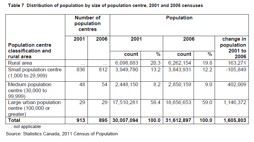
The delineation rules for population centres (POPCTR) are ranked in order of priority:
The resulting population centres are reviewed and may be modified to ensure spatial contiguity where appropriate (for example, the removal of interior holes).
Some population centres may contain commercial and industrial districts, railway yards, airports, parks and other uninhabited areas that result in dissemination blocks with population densities of less than 400 persons per square kilometre. In general, the impact on the total population within population centres is minor, but the impact on specific land areas could be significant. This would affect any programs or research based on precise distance or land area measurements related to individual population centres.
Once a population centre attains a population of 10,000 persons, it is eligible to become the core of a census agglomeration (CA). Once a population centre attains a population of 50,000 and is the core of a census agglomeration with a minimum total population of 100,000, then it is eligible to become the core of a census metropolitan area (CMA). When a population centre with a population of at least 50,000 persons is also the core of a census agglomeration, the census agglomeration is eligible for the census tract program
Prior to 2011, urban areas included a wide range of densely-populated areas, from small centres with a population of 1,000 to very large centres of more than 1 million. This approach ignored size differences by treating all urban areas as a single group. Given the widely accepted view that a more dynamic urban-rural continuum exists, the use of the term 'urban area' could lead to misinterpretations.
Population centres are divided into three groups based on the size of their population to reflect the existence of an urban-rural continuum.
The delineation rules for population centres (POPCTR) are ranked in order of priority:
- The 2006 urban areas are retained as 2011 population centres if their current population is 1,000 or more.
- If a dissemination block with a population density of at least 400 persons per square kilometre is adjacent to a population centre, then it is added to that population centre.
- If a dissemination block or group of contiguous dissemination blocks, each having a minimum population of 1,000 and a population density of at least 400 persons per square kilometre for the current census, then the dissemination block or group of contiguous dissemination blocks is delineated as a new population centre.
- The distance by road between population centres is measured. If the distance is less than two kilometres, then the population centres are combined to form a single population centre, provided they do not cross census metropolitan area (CMA) or census agglomeration (CA) boundaries.
- If a population centre is contained within a census subdivision (CSD) or a designated place (DPL), the difference in land area between the population centre and the CSD or DPL is calculated. For confidentiality purposes, if the difference between the CSD and the population centre is less than 10 square kilometres, then the boundary for the population centre is adjusted to the CSD boundary.
The resulting population centres are reviewed and may be modified to ensure spatial contiguity where appropriate (for example, the removal of interior holes).
Some population centres may contain commercial and industrial districts, railway yards, airports, parks and other uninhabited areas that result in dissemination blocks with population densities of less than 400 persons per square kilometre. In general, the impact on the total population within population centres is minor, but the impact on specific land areas could be significant. This would affect any programs or research based on precise distance or land area measurements related to individual population centres.
Once a population centre attains a population of 10,000 persons, it is eligible to become the core of a census agglomeration (CA). Once a population centre attains a population of 50,000 and is the core of a census agglomeration with a minimum total population of 100,000, then it is eligible to become the core of a census metropolitan area (CMA). When a population centre with a population of at least 50,000 persons is also the core of a census agglomeration, the census agglomeration is eligible for the census tract program
The name of the population centre is the name of the principal census subdivision (CSD) when the CSD is (or was) a city, town or village. If two or more principal CSDs are involved, the population centre may be given a compound name.
In other cases, the name of the population centre is an appropriate place name.
In other cases, the name of the population centre is an appropriate place name.
Population centre codes are unique four-digit codes that are assigned sequentially upon the POPCTR creation. These codes remain constant between censuses. The previous 2006 urban area codes are retained for the 2011 population centres. If a population centre is retired due to amalgamation or failure to meet the population or density thresholds, then its code is retired.
It is recommended that the two-digit province/territory (PR) code precede the POPCTR code in order to identify each POPCTR uniquely within its corresponding province/territory. For example:
Five POPCTRs straddle provincial boundaries: Campbellton (New Brunswick and Quebec), Hawkesbury (Ontario and Quebec), Ottawa - Gatineau (Ontario and Quebec), Flin Flon (Manitoba and Saskatchewan) and Lloydminster (Alberta and Saskatchewan).
For 2011, the DPL of Cowichan 1 (DPL 59 0321) in British Columbia overlaps the POPCTR of Duncan (POPCTR 0243). In an effort to minimize data suppression for this area, this DPL represents a formerly discontiguous Aboriginal community which has been combined to form a single discontiguous census subdivision (CSD).
Table 1 in the Introduction shows the number of population centres by province and territory.
Refer to the related definitions of census metropolitan area (CMA) and census agglomeration (CA); census subdivision (CSD); core, fringe and rural area; designated place (DPL); dissemination block (DB); land area; place name (PN) and population density.
It is recommended that the two-digit province/territory (PR) code precede the POPCTR code in order to identify each POPCTR uniquely within its corresponding province/territory. For example:
| PR-POPCTR code | POPCTR name | |
| 11 0159 | Charlottetown (P.E.I.) | |
| 13 0122 | Campbellton (N.B.) | |
| 24 0122 | Campbellton (Que.) | |
| 46 0282 | Flin Flon (Man.) | |
| 47 0282 | Flin Flon (Sask.) | |
| 60 1023 | Whitehorse (Y.T.) | |
Five POPCTRs straddle provincial boundaries: Campbellton (New Brunswick and Quebec), Hawkesbury (Ontario and Quebec), Ottawa - Gatineau (Ontario and Quebec), Flin Flon (Manitoba and Saskatchewan) and Lloydminster (Alberta and Saskatchewan).
For 2011, the DPL of Cowichan 1 (DPL 59 0321) in British Columbia overlaps the POPCTR of Duncan (POPCTR 0243). In an effort to minimize data suppression for this area, this DPL represents a formerly discontiguous Aboriginal community which has been combined to form a single discontiguous census subdivision (CSD).
Table 1 in the Introduction shows the number of population centres by province and territory.
Refer to the related definitions of census metropolitan area (CMA) and census agglomeration (CA); census subdivision (CSD); core, fringe and rural area; designated place (DPL); dissemination block (DB); land area; place name (PN) and population density.
The term 'urban area' existed at Statistics Canada from the 1961 to 2006 censuses.
For 2006, the boundaries of 412 urban areas for 2001 were adjusted to correct for over-bounding which largely resulted from the 2001 block structure. This correction resulted in the reduction of land area of these 2001 urban areas in preparation for the delineation of the 2006 urban areas. The correction also resulted in the reinstatement of four urban areas for 2006 which had been merged with other urban areas in 2001: Fortune (10 0300), Sainte-Croix (24 0878), Châteauguay (24 1177) and Dowling (35 1084).
One of the 2006 urban areas, Attawaspiskat 91A (UA 35 1275), was an area that had been identified as being an incompletely enumerated Indian reserve. Data for 2006 were not available for the incompletely enumerated reserves and settlements, and were not included in tabulations. Because of the missing data, users were cautioned that for the affected geographic areas, comparisons (e.g., percentage change) between 2001 and 2006 were not exact.
In 2001, the delineation of urban areas became an automated process that made it possible to use population counts and population density data from the current census.
Prior to 2001, the geographic units used for urban area delineation were census subdivisions, designated places and enumeration areas. Population counts and population density from the previous census were used in all cases, except when enumeration area boundaries had been adjusted for the current census.
For 1976, urban areas contained a population concentration of at least 1,000 persons and a population density of at least 1,000 persons per square mile (386 per square kilometre). Urban areas were combined if they were separated by less than one mile (1.6 kilometres).
For 1971, 1966 and 1961, urban areas included:
- all incorporated cities, towns and villages with a population of 1,000 persons or over;
- all unincorporated places with a population of 1,000 persons or over and a population density of at least 1,000 persons per square mile; and
- the urbanized fringe and the urbanized core of a census agglomeration or census metropolitan area, that had a minimum population of 1,000 persons and a density of at least 1,000 persons per square mile.
Portion of Canada's land area governed by a political authority. Canada is divided into 10 provinces and 3 territories.
'Province' and 'territory' refer to the major political units of Canada. From a statistical point of view, province and territory are basic areas for which data are tabulated. Canada is divided into 10 provinces and 3 territories.
Statistics Canada uses standard codes and abbreviations to represent provinces and territories. The two-digit code that uniquely identifies each province/territory is based on the Standard Geographical Classification (SGC). The code is assigned from east to west. The first digit represents the geographical region of Canada in which the province/territory is located and the second digit denotes one of the 10 provinces and 3 territories (Table 8).
Effective October 20, 2008, the names 'Yukon Territory' in English and 'Territoire du Yukon' in French become 'Yukon' in English and in French, as per the Yukon Act (Chapter 7, assented March 27, 2002).
Users should be aware that there is no change to the abbreviations or to the numeric and alpha codes for Yukon. The abbreviations remain Y.T. in English and Yn in French, 60 for the numeric code and YT for the alpha code.
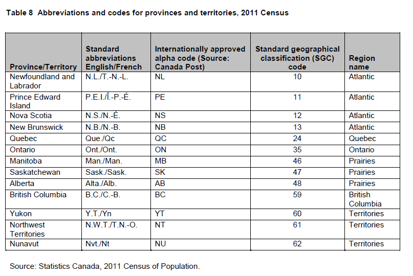
Refer to the related definitions of census division (CD) and Standard Geographical Classification (SGC).
Effective October 20, 2008, the names 'Yukon Territory' in English and 'Territoire du Yukon' in French become 'Yukon' in English and in French, as per the Yukon Act (Chapter 7, assented March 27, 2002).
Users should be aware that there is no change to the abbreviations or to the numeric and alpha codes for Yukon. The abbreviations remain Y.T. in English and Yn in French, 60 for the numeric code and YT for the alpha code.
Refer to the related definitions of census division (CD) and Standard Geographical Classification (SGC).
Rural areas (RAs) include all territory lying outside population centres (POPCTRs). Taken together, population centres and rural areas cover all of Canada.
Rural population includes all population living in rural areas of census metropolitan areas (CMAs) and census agglomerations (CAs), as well as population living in rural areas outside CMAs and CAs.
Rural population includes all population living in rural areas of census metropolitan areas (CMAs) and census agglomerations (CAs), as well as population living in rural areas outside CMAs and CAs.
The rural area of Canada is the area that remains after the delineation of population centres using current census population data.
Within rural areas, population densities and living conditions can vary greatly. Included in rural areas are:
Within rural areas, population densities and living conditions can vary greatly. Included in rural areas are:
- small towns, villages and other populated places with less than 1,000 population according to the current census
- rural areas of census metropolitan areas and census agglomerations that may contain estate lots, as well as agricultural, undeveloped and non-developable lands
- agricultural lands
- remote and wilderness areas.
One side of a street between two consecutive intersections, such as one side of a city block.
A block-face is one side of a street between two consecutive features intersecting that street. The features can be other streets or boundaries of standard geographic areas.
Block-faces are used for generating block-face representative points, which in turn are used for geocoding and census data extraction when the street and address information are available.
Block-faces are used for generating block-face representative points, which in turn are used for geocoding and census data extraction when the street and address information are available.
Population and dwelling counts are not disseminated for individual block-faces, since there are confidentiality concerns about releasing small population and dwelling counts at this level of geography.
Table 1 in the Introduction shows the number of block-faces by province and territory.
Refer to related definitions of geocoding; representative point and Spatial Data Infrastructure (SDI).
Table 1 in the Introduction shows the number of block-faces by province and territory.
Refer to related definitions of geocoding; representative point and Spatial Data Infrastructure (SDI).
Major changes in 2001:
Prior to 1991, block-faces were not created when EA boundaries split city blocks.
- Block-faces were defined for the entire country, rather than only in urban centres covered by the former street network files.
- Block-faces were formed by addressable and non-addressable streets, rather than by addressable streets only.
- Two block-faces were generated opposite a road T-junction, rather than just one block-face.
- Block-faces were not formed when physical features (such as rivers or railroads) intersected the road unless these features were coincident with a boundary of a standard geographic area.
- Block-faces were not formed when a single-address enumeration area (EA) was smaller than a city block. In these cases, the EA was offset from the street, rather than digitally represented as a polygon intersecting the street.
- Block-faces were formed when streets crossed the limits of map tiles (the map tiles, which were based on the National Topographic System of Natural Resources Canada, formed the Canada-wide coverage in the 2001 National Geographic Base).
- Population and dwelling counts were not disseminated for individual block-faces.
- Block-faces were defined only in urban centres covered by street network files.
- Block-faces were formed by addressable streets only.
- Only one block-face was generated opposite a road T-junction.
- Block-faces were formed when physical features intersected roads even when the boundaries of standard geographic areas were not coincident with these features.
- Block-faces were formed when a single-address EA was smaller than a city block since the EA was digitally represented as a polygon intersecting the street.
- Block-faces were not formed when streets crossed the limits of map tiles, since map tiles were not used.
- Population and dwelling counts were disseminated for individual block-faces.
Prior to 1991, block-faces were not created when EA boundaries split city blocks.
A coordinate system is a reference system based on mathematical rules for specifying positions (locations) on the surface of the earth. The coordinate values can be spherical (latitude and longitude) using angular units of measure such as degrees, minutes and seconds or planar (Universal Transverse Mercator) using linear units such as metres.
Cartographic boundary files, digital boundary files, representative points and road network files are disseminated in latitude/longitude coordinates.
Cartographic boundary files, digital boundary files, representative points and road network files are disseminated in latitude/longitude coordinates.
2011, 2006, 2001, 1996, 1991, 1986, 1981 (latitude/longitude)
1996, 1991, 1986, 1981, 1976, 1971 (Universal Transverse Mercator)
1996, 1991, 1986, 1981, 1976, 1971 (Universal Transverse Mercator)
A coordinate system is usually defined by a datum, ellipsoid and projection, and is specified in terms of units (e.g., degrees, metres).
Latitude and longitude coordinates, often referred to as geographic coordinates, are spherical. Lines of latitude (also called parallels) run in an east-west direction around the earth parallel to the equator. Latitude is the angular measurement of a location expressed in degrees north or south of the equator, ranging from 0o at the equator to 90oN or 90oS at the poles. Lines of longitude (also called meridians) run in a north-south direction from pole to pole.
Longitude is the angular measurement of a location east or west of the prime meridian (which runs through Greenwich, England), ranging from 0o at the prime meridian to 180oE or 180oW. The 180th meridian is the approximate location of the International Date Line.
For the land mass of Canada, latitudes range from about 42oN to 83oN and longitudes range from approximately 53oW to 141oW.
Latitude coordinates south of the equator and longitude coordinates west of the prime meridian have minus signs when stored in a digital database. Latitude/longitude coordinates are convenient for transferring and disseminating spatial digital data, and are normally expressed in decimal degrees on a database. However, maps should not be generated using these spherical coordinates, as they are unprojected, resulting in a map that appears distorted (see Figure 14 in map projection definition).
It is now common for geographic information system (GIS) software to convert coordinates from one frame of reference to coordinates of another frame of reference, such as transforming the Lambert conformal conic projection to latitude/longitude coordinates.
The Universal Transverse Mercator (UTM) coordinate system is no longer used as the working coordinate system or for disseminating spatial digital data.
Refer to related definitions of cartographic boundary files (CBFs); datum; digital boundary files (DBFs); map projection; representative point; road network file (RNF) and Spatial Data Infrastructure (SDI).
A datum is a geodetic reference system which includes an ellipsoid and an origin against which the latitude and longitude of all other points on the earth's surface are referenced. A datum may often be associated with a particular ellipsoid (mathematical reference model of the earth).
2011, 2006, 2001 (North American Datum of 1983)
1996, 1991, 1986, 1981, 1976, 1971 (North American Datum of 1927)
1996, 1991, 1986, 1981, 1976, 1971 (North American Datum of 1927)
Datums and the coordinate reference systems based on them were developed to describe geographic positions for surveying, mapping and navigation. Over the years, datums evolved from spherical to ellipsoidal models using satellite measurements. The earth is not a sphere, but an ellipsoid flattened slightly at the poles and bulging somewhat at the equator. The ellipsoid is used as a surface of reference for the mathematical model of the earth. Since mathematical models of the size and shape of the earth are now more precise, it has become necessary to change to a more accurate model.
There are two datums used in Canada: the North American Datum of 1927 (NAD27) and the North American
Datum of 1983 (NAD83). Both are geodetic reference systems, but each is based on different measurements and reference ellipsoids. The NAD27 is based on the Clarke ellipsoid of 1866, and its reference point is a fixed point in Kansas.
The NAD83 is an earth-centred datum based on a newly defined ellipsoid - the Geodetic Reference System of 1980 (GRS80) - and its reference point is the centre of the earth, as opposed to a point on the earth's surface.
The National Transformation software, developed by the Geodetic Survey of Canada, is used to convert coordinates between the NAD27 and the NAD83 reference systems in Canada. Spatial data based on one datum will not be coincident with the same spatial data based on another datum. Positional differences between NAD27 and NAD83 can be as great as hundreds of metres in some instances. Other longitudinal analyses will also be affected by a change in datum. For example, block-face and census subdivision (CSD) representative points from censuses prior to 2001 may not fall in the correct current census standard geographic area due to a shift caused by using different datums.
Refer to the related definitions of cartographic boundary files (CBFs); coordinate system; digital boundary files (DBFs); map projection; representative point; road network file (RNF) and Spatial Data Infrastructure (SDI).
Ecumene is a term used by geographers to mean inhabited land. It generally refers to land where people have made their permanent home, and to all work areas that are considered occupied and used for agricultural or any other economic purpose. Thus, there can be various types of ecumenes, each having its own unique characteristics (population ecumene, agricultural ecumene, industrial ecumene, etc.).
2011, 2006, 2001, 1996, 1991, 1986, 1981, 1976 (national population ecumene)
2011, 2006, 2001, 1996, 1991, 1986, 1981, 1976 (national agricultural ecumene)
1986 (urban population ecumene for 12 census metropolitan areas)
2011, 2006, 2001, 1996, 1991, 1986, 1981, 1976 (national agricultural ecumene)
1986 (urban population ecumene for 12 census metropolitan areas)
Ecumene is derived from the Greek root oixos meaning inhabited and nenon meaning space.
Statistics Canada delineates the population and agricultural ecumenes as follows:
Refer to related definitions of cartographic boundary files (CBFs); datum; dissemination area (DA); dissemination block (DB); Spatial Data Infrastructure (SDI) and thematic map.
Statistics Canada delineates the population and agricultural ecumenes as follows:
- The national population ecumene includes dissemination blocks with a minimum population density. To ensure visibility for small-scale thematic mapping, the detailed ecumene limits are manually generalized and small, discontiguous ecumene pockets are aggregated.
- The national agricultural ecumene includes all dissemination areas with 'significant' agricultural activity. Agricultural indicators, such as the ratio of agricultural land on census farms relative to total land area, and total economic value of agricultural production, are used. Regional variations are also taken into account. The ecumene is generalized for small-scale mapping.
Refer to related definitions of cartographic boundary files (CBFs); datum; dissemination area (DA); dissemination block (DB); Spatial Data Infrastructure (SDI) and thematic map.
Geocoding is the process of assigning geographic identifiers (codes or x,y coordinates) to map features and data records. The resulting geocodes permit data to be linked geographically to a place on the earth.
Households, postal codesOM and place of work data are linked to block-face representative points (coordinates) when the street and address information is available; otherwise, they are linked to dissemination block (DB) representative points. In some cases, postal codesOM and place of work data are linked to dissemination area (DA) representative points when they cannot be linked to DBs. As well, place of work data are linked to census subdivision representative points when the data cannot be linked to DAs.
Households, postal codesOM and place of work data are linked to block-face representative points (coordinates) when the street and address information is available; otherwise, they are linked to dissemination block (DB) representative points. In some cases, postal codesOM and place of work data are linked to dissemination area (DA) representative points when they cannot be linked to DBs. As well, place of work data are linked to census subdivision representative points when the data cannot be linked to DAs.
Statistics Canada's Custom Area Creation Service provides census data tabulations for user-defined areas, such as provincial electoral districts, local planning areas and school districts. When tabulating census data for user-defined areas, households are included or excluded depending on whether the representative points to which they are linked fall inside or outside the user-defined area (Figure 13). Thus, the data retrieved are most precise when user-defined areas coincide with dissemination block boundaries. Census data for individual block-faces are not disseminated.
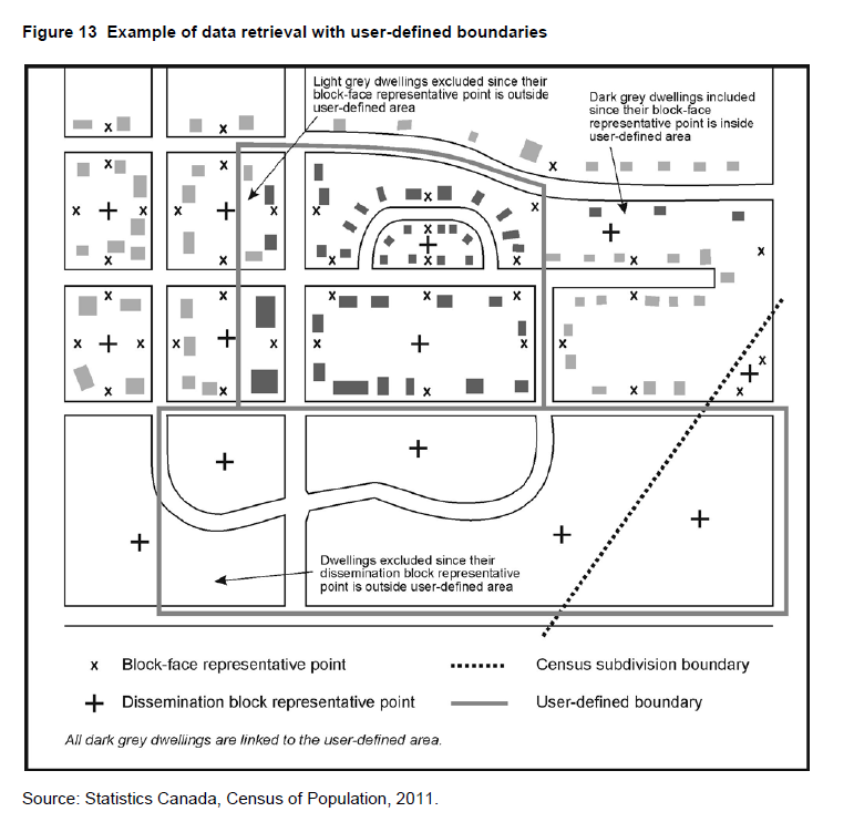
Refer to related definitions of block-face; census subdivision (CSD); dissemination area (DA); dissemination block (DB); postal codeOM; representative point and Spatial Data Infrastructure (SDI).
Refer to related definitions of block-face; census subdivision (CSD); dissemination area (DA); dissemination block (DB); postal codeOM; representative point and Spatial Data Infrastructure (SDI).
Prior to 2001, households, postal codesOM and place of work data were linked to enumeration area (EA) representative points when they could not be linked to block-face representative points. As well, unrounded block-face population counts were provided for user confirmation before tabulating characteristic data for custom areas.
A map projection is the process of transforming and representing positions from the earth's three-dimensional curved surface to a two-dimensional (flat) surface. The process is accomplished by a direct geometric projection or by a mathematically derived transformation.
The Lambert conformal conic map projection is widely used for general maps of Canada at small scales and is the most common map projection used at Statistics Canada.
The Lambert conformal conic map projection is widely used for general maps of Canada at small scales and is the most common map projection used at Statistics Canada.
2011, 2006, 2001, 1996, 1991, 1986, 1981, 1976 (Lambert conformal conic)
1996, 1991, 1986, 1981, 1976, 1971 (Transverse Mercator)
1996, 1991, 1986, 1981, 1976, 1971 (Transverse Mercator)
The Earth's surface cannot be flattened without distorting geometrical properties, such as area, shape, distance and direction. These spatial properties can be preserved individually (at least locally) and in certain combinations on map projections. However, the four basic properties of area, shape, distance and direction cannot all be held true simultaneously. Therefore, it is important to select a projection having the properties that are suited to the mapping situation. For example, a projection that accurately represents the shapes of the continents will distort their relative sizes.
The Lambert conformal conic projection (Figure 14) provides good directional and shape relationships for mid-latitude regions having a mainly east-to-west extent. Standard parallels at 49°N and 77°N are most commonly used.
The scale is correct along the standard parallels only; areal deformation decreases between and increases away from the standard parallels. The central meridian, normally at 91°52'W, is a straight line about which the projection is symmetrical. False eastings and northings are given to ensure positive coordinate values in linear units of measure (metres).
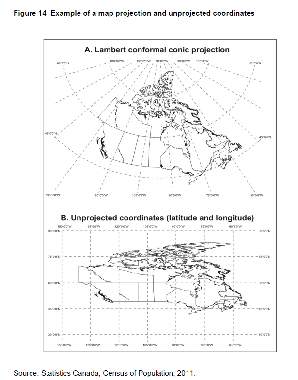
Latitude and longitude is not a map projection, as the coordinates are spherical (angular units of measure such as degrees, minutes and seconds) therefore unprojected. It is recommended that maps not be generated using these spherical coordinates because they result in maps that are distorted (Figure 14).
The Lambert conformal conic map projection is the working projection for cartographic boundary files, digital boundary files, road network files and the Spatial Data Infrastructure, and for generating representative points.
Refer to related definitions of cartographic boundary files (CBFs); coordinate system; datum; digital boundary files (DBFs); representative point; road network file (RNF) and Spatial Data Infrastructure (SDI).
The Lambert conformal conic projection (Figure 14) provides good directional and shape relationships for mid-latitude regions having a mainly east-to-west extent. Standard parallels at 49°N and 77°N are most commonly used.
The scale is correct along the standard parallels only; areal deformation decreases between and increases away from the standard parallels. The central meridian, normally at 91°52'W, is a straight line about which the projection is symmetrical. False eastings and northings are given to ensure positive coordinate values in linear units of measure (metres).
Latitude and longitude is not a map projection, as the coordinates are spherical (angular units of measure such as degrees, minutes and seconds) therefore unprojected. It is recommended that maps not be generated using these spherical coordinates because they result in maps that are distorted (Figure 14).
The Lambert conformal conic map projection is the working projection for cartographic boundary files, digital boundary files, road network files and the Spatial Data Infrastructure, and for generating representative points.
Refer to related definitions of cartographic boundary files (CBFs); coordinate system; datum; digital boundary files (DBFs); representative point; road network file (RNF) and Spatial Data Infrastructure (SDI).
A reference map shows the location of the geographic areas for which census data are tabulated and disseminated. The maps display the boundaries, names and unique identifiers of standard geographic areas, as well as major cultural and physical features, such as roads, railroads, coastlines, rivers and lakes.
The boundaries, names and unique identifiers of the standard geographic areas reflect those in effect on January 1, 2011 (the geographic reference date for the 2011 Census).
The geographic area boundaries, names, types and unique identifiers, and the relationships among the various geographic levels, are found on Statistics Canada's Spatial Data Infrastructure. The vector base map information (coastlines, rivers and lakes) is taken from the National Geographic Database. Water toponymy (river names, lake names, names of bays, oceans, gulfs, straits, seas and islands) is taken from the Canadian Geographical Names Data Base maintained by Natural Resources Canada.
Reference maps can assist users in relating published census data to actual locations on the ground, or in defining their own custom areas relative to the standard geographic areas.
Refer to related definitions of geographic reference date; Spatial Data Infrastructure (SDI) and to the Reference Maps and Thematic Maps, Reference Guide (Catalogue no. 92-143-G).
A representative point is a coordinate point that represents a line or a polygon. The point is centrally located along the line, and centrally located or population weighted in the polygon.
Representative points are generated for block-faces, as well as for selected geographic areas - province/territory (PR), federal electoral district (FED), economic region (ER), census division (CD), census metropolitan area/census agglomeration (CMA/CA), census subdivision (CSD), population centre (POPCTR), designated place (DPL), census tract (CT), dissemination area (DA) and dissemination block (DB).
Households, postal codesOM and place of work data are linked to block-face representative points (coordinates) when the street and address information is available; otherwise, they are linked to dissemination block (DB) representative points. In some cases, postal codes and place of work data are linked to dissemination area (DA) representative points when they cannot be linked to DBs. As well, place of work data are linked to census subdivision (CSD) representative points when the data cannot be linked to DAs.
Representative points are located by the following methods:
1. Block-face representative points
The block-face representative points are generated using the ArcGIS® software (version 9.3.1) in conjunction with the Spatial Data Infrastructure, including selected water polygon. The points are initially calculated and stored based on the Lambert conformal conic projection; they are also transformed to latitude/longitude coordinates.
The block-face representative points are computed along addressable and non-addressable streets, midway (or approximately midway) between two consecutive features intersecting a street. The intersecting features can be other streets or boundaries of standard geographic areas.
The points are set back a perpendicular distance of 10, 5, 1 or 0.5 metres from the street centre line to ensure that all points have unique coordinates, and are located in the correct block and on the correct side of the street.
Some block-face representative points may fall in water bodies if the points are adjacent to bridges or causeways.
Some geometry shifts and realignments may cause 2011 representative points for block-faces to be different from 2006.
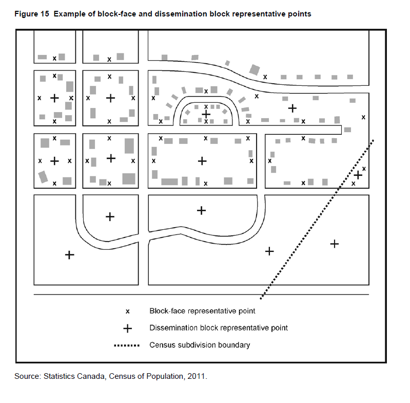
2. Geographic area representative points
The representative points for standard geographic areas are generated using ArcGIS® software (version 9.3.1) in conjunction with their respective digital boundary file (DBF). The most detailed hydrography is used to ensure that representative points do not fall in water where possible. The points are initially calculated and stored based on the Lambert conformal conic projection; they are also transformed to latitude/longitude coordinates.
Representative points for 2011 are generated for the dissemination block (DB) as label points to ensure they do not fall in water. The geographic area representative points are initially derived as centroids, which may fall in water.
To ensure geographic area representative points do not fall in water, except in cases where entire polygons are in water, the DB representative point nearest to the geographic area centroid is selected as the new representative point for the geographic area.
A. Unweighted representative points
The representative points for all geographic areas excluding the dissemination area are unweighted. The points are generated using the ArcGIS® software. The software locates the point as nearest to the geographical centre of the polygon as possible, ensuring the point falls on land areas whenever possible. Topology checks are applied to ensure that the points fall within the appropriate geographic area. Since some dissemination blocks and designated places are located in water only, their representative points will fall in water. Where the geographic area is in multiple parts, the point is located in the portion having the largest area.
Figure 15 shows an example of dissemination block representative points.
B. Weighted representative points
Mean centre weighted by population
The representative points for dissemination areas (DAs) are weighted using the population mean centre. Formula 1 depicts the mathematical methods for calculating the weighted mean centre representative points. One of two pairs of equations is used, depending on the population of the DA. The first pair of equations is used when the DA has a population greater than zero. The second equation is used when the DA has a population equal to zero.
In the first pair of equations, the x-coordinate is calculated by first multiplying the population of each dissemination block (DB) in the DA by the x-coordinate (easting) of its representative point. The products are summed over all DBs in the DA, and the result is then divided by the total population of the DA. The y-coordinate (northing) of the DA is calculated by applying the same methodology, only using the y-coordinate information for the component DBs.
The second pair of equations is used when the DA has zero population. For this, the x-coordinate (easting) is calculated by summing the x-coordinate of the representative points of all DBs in the DA. This sum is then divided by the number of DBs in the DA. The y-coordinate (northing) of the DA is calculated by applying the same methodology, only using the y-coordinate information for the component DBs.
Examples of calculating the mean centre representative points weighted by population using the above methods are shown immediately below the formulae.
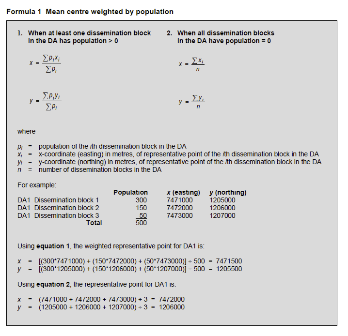
Minimum squared distance weighted by population
If any weighted representative points fall outside the dissemination area (DA) (e.g., for crescent-shaped polygons) or fall in water bodies, the points are generated using the minimum squared distance weighted by population (formula 2). The first equation is used when the DA has a population greater than zero. The second equation is used when the DA has a population equal to zero.
In the first equation, the population weighted squared distance is calculated for each dissemination block (DB) and the DB with the minimum value is chosen. For each DB, the population weighted squared distance is calculated by measuring the distance between its representative point and the representative points of all other DBs. Each distance is then squared and further multiplied by the population of the other DBs. These values are then all summed to create a value for the DB in question.
In the second equation, an unweighted squared distance is calculated for each DB, and the DB with the minimum value is chosen. For each DB, the population weighted squared distance is calculated by measuring the distance between its representative point and the representative points of all other DBs. Each distance is then squared and these values are all summed to create a value for the DB in question.
Topology checks are applied to ensure that the points fall within the DA. Since some DAs are located in water only, their representative points fall in water.
Examples of calculating the minimum squared distance representative point weighted by population using the above methods are shown immediately below the formulae.
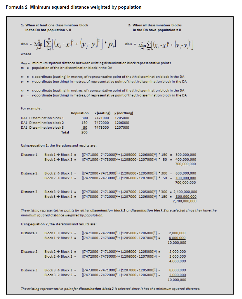
Refer to related definitions of block-face; census subdivision (CSD); designated place (DPL); digital boundary files (DBFs); dissemination area (DA); dissemination block (DB); geocoding; population centre (POPCTR); postal code; Spatial Data Infrastructure (SDI) and the Postal Code Conversion File (PCCF), Reference Guide (Catalogue no. 92-153-G).
1. Block-face representative points
The block-face representative points are generated using the ArcGIS® software (version 9.3.1) in conjunction with the Spatial Data Infrastructure, including selected water polygon. The points are initially calculated and stored based on the Lambert conformal conic projection; they are also transformed to latitude/longitude coordinates.
The block-face representative points are computed along addressable and non-addressable streets, midway (or approximately midway) between two consecutive features intersecting a street. The intersecting features can be other streets or boundaries of standard geographic areas.
The points are set back a perpendicular distance of 10, 5, 1 or 0.5 metres from the street centre line to ensure that all points have unique coordinates, and are located in the correct block and on the correct side of the street.
Some block-face representative points may fall in water bodies if the points are adjacent to bridges or causeways.
Some geometry shifts and realignments may cause 2011 representative points for block-faces to be different from 2006.
2. Geographic area representative points
The representative points for standard geographic areas are generated using ArcGIS® software (version 9.3.1) in conjunction with their respective digital boundary file (DBF). The most detailed hydrography is used to ensure that representative points do not fall in water where possible. The points are initially calculated and stored based on the Lambert conformal conic projection; they are also transformed to latitude/longitude coordinates.
Representative points for 2011 are generated for the dissemination block (DB) as label points to ensure they do not fall in water. The geographic area representative points are initially derived as centroids, which may fall in water.
To ensure geographic area representative points do not fall in water, except in cases where entire polygons are in water, the DB representative point nearest to the geographic area centroid is selected as the new representative point for the geographic area.
A. Unweighted representative points
The representative points for all geographic areas excluding the dissemination area are unweighted. The points are generated using the ArcGIS® software. The software locates the point as nearest to the geographical centre of the polygon as possible, ensuring the point falls on land areas whenever possible. Topology checks are applied to ensure that the points fall within the appropriate geographic area. Since some dissemination blocks and designated places are located in water only, their representative points will fall in water. Where the geographic area is in multiple parts, the point is located in the portion having the largest area.
Figure 15 shows an example of dissemination block representative points.
B. Weighted representative points
Mean centre weighted by population
The representative points for dissemination areas (DAs) are weighted using the population mean centre. Formula 1 depicts the mathematical methods for calculating the weighted mean centre representative points. One of two pairs of equations is used, depending on the population of the DA. The first pair of equations is used when the DA has a population greater than zero. The second equation is used when the DA has a population equal to zero.
In the first pair of equations, the x-coordinate is calculated by first multiplying the population of each dissemination block (DB) in the DA by the x-coordinate (easting) of its representative point. The products are summed over all DBs in the DA, and the result is then divided by the total population of the DA. The y-coordinate (northing) of the DA is calculated by applying the same methodology, only using the y-coordinate information for the component DBs.
The second pair of equations is used when the DA has zero population. For this, the x-coordinate (easting) is calculated by summing the x-coordinate of the representative points of all DBs in the DA. This sum is then divided by the number of DBs in the DA. The y-coordinate (northing) of the DA is calculated by applying the same methodology, only using the y-coordinate information for the component DBs.
Examples of calculating the mean centre representative points weighted by population using the above methods are shown immediately below the formulae.
Minimum squared distance weighted by population
If any weighted representative points fall outside the dissemination area (DA) (e.g., for crescent-shaped polygons) or fall in water bodies, the points are generated using the minimum squared distance weighted by population (formula 2). The first equation is used when the DA has a population greater than zero. The second equation is used when the DA has a population equal to zero.
In the first equation, the population weighted squared distance is calculated for each dissemination block (DB) and the DB with the minimum value is chosen. For each DB, the population weighted squared distance is calculated by measuring the distance between its representative point and the representative points of all other DBs. Each distance is then squared and further multiplied by the population of the other DBs. These values are then all summed to create a value for the DB in question.
In the second equation, an unweighted squared distance is calculated for each DB, and the DB with the minimum value is chosen. For each DB, the population weighted squared distance is calculated by measuring the distance between its representative point and the representative points of all other DBs. Each distance is then squared and these values are all summed to create a value for the DB in question.
Topology checks are applied to ensure that the points fall within the DA. Since some DAs are located in water only, their representative points fall in water.
Examples of calculating the minimum squared distance representative point weighted by population using the above methods are shown immediately below the formulae.
Refer to related definitions of block-face; census subdivision (CSD); designated place (DPL); digital boundary files (DBFs); dissemination area (DA); dissemination block (DB); geocoding; population centre (POPCTR); postal code; Spatial Data Infrastructure (SDI) and the Postal Code Conversion File (PCCF), Reference Guide (Catalogue no. 92-153-G).
Prior to 2001, enumeration area (EA) representative points were disseminated.
Prior to 1996, all representative points were called 'centroids1'.
1. Geographic area representative points
Prior to 1996, all representative points were called 'centroids1'.
1. Geographic area representative points
- For 2006, the representative points for geographic areas were generated as centroids and then moved if they fell into water bodies.
- For 2001, the representative points for blocks, dissemination areas, census subdivisions and designated places could fall in water bodies. In addition, the dissemination area points were not weighted.
- For 1996, EA representative points were disseminated in latitude/longitude coordinates and in x,y coordinates of the Lambert conformal conic projection. The representative points were created either with the Street Network File (SNF) or manually.
- Representative points located in EAs within the SNF were created using the ArcGIS® software, which located the point suitable for label or symbol placement in each polygon. Steps were taken so that the points did not fall in water bodies. If the EA was in multiple parts, the point was located, when possible, in the portion with the largest number of occupied private dwellings (based on the 1991 block-face counts). In some cases, however, the representative point was located in the EA portion having the largest land area.
- Representative points located in EAs outside SNF coverage were created by a manual procedure based on the visual inspection of building and/or street patterns on EA reference maps (some of which had topographic base map information). The representative point was located, when possible, within a predominant cluster of buildings and/or streets. If there was no predominant cluster, then the point was located between two or more clusters. In the absence of any cluster, the point was placed at the visual centre of the EA. If an EA was in multiple parts, the point was located in the portion with the largest number of dwellings. The representative point was located in the land-based portion of the EA.
- For 1991, the EA representative points within SNF coverage were created using the ArcGIS® software, which locates the point suitable for label or symbol placement in each polygon; some points were located in water bodies. In addition, for EAs in multiple parts in SNF coverage, there was no rule for selecting the EA part to which the representative point was assigned. The EA representative points were disseminated in latitude/longitude coordinates, UTM coordinates, and in x,y coordinates of the Lambert conformal conic projection.
- Prior to 1991, EA representative points within SNF coverage were computed by a different method. An algorithm selected one of the existing block-face representative points (based on their number and concentration) within an EA as the overall EA representative point. The points were calculated and disseminated in UTM coordinates.
- For 2001, block-face representative points were set back a distance of 10, 5 or 1 metre(s) from the street centre line. As well, points were generated when streets crossed the limits of National Topographic Database (NTDB) map tiles.
- Prior to 2001, block-face representative points were not generated when streets crossed the limits of map tiles, since map tiles were not used.
- For 1996, block-face representative points were generated within street network file (SNF) coverage only, and the points were set back a distance of 22, 11, 5 or 1 metre(s) from the street centre line. The points were calculated in Universal Transverse Mercator (UTM) coordinates, but were disseminated in latitude/longitude coordinates.
- Prior to 1996, some block-face representative points did not have unique coordinate values, and all points were set back a perpendicular distance of 22 metres from the street centre line. The points were calculated and disseminated in UTM coordinates.
- Prior to 1991, block-faces were not created when EA boundary segments did not follow visible features.
A thematic map shows the spatial distribution of one or more specific data themes for selected geographic areas. The map may be qualitative in nature (e.g., predominant farm types) or quantitative (e.g., percentage population change).
A thematic map is also called a special-purpose, single-topic, or statistical map. A thematic map focuses on the spatial variability of a specific distribution or theme (such as population density or average annual income), whereas a reference map focuses on the location and names of features. Thematic maps normally include some locational or reference information, such as place names or major water bodies, to help map readers familiarize themselves with the geographic area covered on the map.
All thematic maps are composed of two important elements: a base map and statistical data. Normally, the two are available as digital files, such as a cartographic boundary file and census data. Desk-top geographic information systems or computer-mapping packages are typically used to generate thematic maps.
Two common thematic maps produced at Statistics Canada are dot maps and choropleth1 maps. The ecumene concept is generally used for dot and choropleth maps, to ensure that the spatial representation of census data is limited to inhabited land. To ensure confidentiality, all census data are subject to random rounding and/or data suppression.
Thematic maps can be used for exploratory spatial data analysis, confirming hypotheses, synthesizing spatial data by revealing patterns and relationships, and data presentation.
Refer to related definitions of cartographic boundary files (CBFs); ecumene and reference map.
1The term 'choropleth' is derived from the Greek choros, for place, and plethos, for magnitude. The choropleth method symbolizes statistical data as they occur within the boundaries of predefined geographic units (such as census divisions or census tracts). Usually, the data are grouped into a limited number of classes, with each class representing a range of data values. A logical sequence of colours or grey tones is then applied to each class. It is important to note that choropleth maps should use standardized data values (e.g., ratios or percentages) rather than absolute values.
The geographic reference date is a date determined by Statistics Canada for the purpose of finalizing the geographic framework for which census data will be collected, tabulated and reported. For the 2011 Census, the geographic reference date is January 1, 2011.
Names, boundaries and other attributes of geographic areas change frequently (examples of these changes include municipal amalgamations and annexations, and changes in the name and status of municipalities). Since the geographic framework is used for census data collection, the geographic reference date must be set sufficiently in advance of Census Day to permit all changes to be processed in time. Furthermore, notification of these changes is normally not received from the applicable federal and provincial authorities until after the changes have occurred. For these reasons, the census reports data according to the geographic areas that are in effect on January 1, 2011, provided that Statistics Canada receives the information on the changes by March 1, 2011.
Since the geographic framework is established according to the geographic areas in effect as of January 1, 2011, and census data refer to conditions as they exist on Census Day (May 10, 2011), census data may be reported for geographic areas that have subsequently changed during this period.
The geographic framework established for census purposes may not reflect the actual geographic framework in effect on January 1, 2011, if Statistics Canada never receives, or does not receive by March 1, 2011, the appropriate notification from relevant federal and provincial authorities.
The postal codeOM is a six-character code defined and maintained by Canada Post Corporation for the purpose of sorting and delivering mail.
The form of the postal codeOM is 'ANA NAN', where A is an alphabetic character and N is a numeric character. The first character of a postal codeOM represents a province or territory, or a major sector entirely within a province (Table 9).
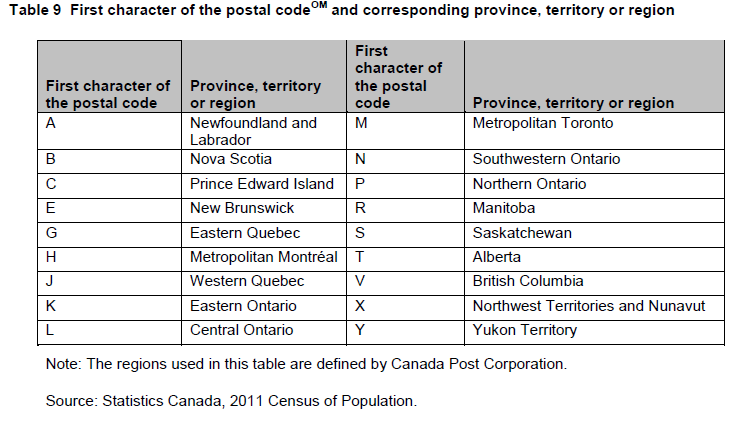
The first three characters of the postal codeOM identify the forward sortation area (FSA). FSAs are associated with a postal facility from which mail delivery originates.
Table 1 in the Introduction shows the number of postal codesOM and forward sortation areas by province and territory. They are provided by Canada Post Corporation and are valid as of May 2011.
The postal codeOM is captured for all households from the address information provided by the respondent on the front page of the census questionnaire on May 10, 2011. The respondent's postal codeOM is accepted whether or not it is the same as the postal codeOM assigned by Canada Post Corporation to that address. The postal codeOM of a household is validated and processed using the following criteria:
Users should proceed with caution if postal codesOM are used as a proxy for standard geographic areas. Postal codesOM do not necessarily respect the boundaries of standard geographic areas (e.g., the same postal codeOM can fall in two or more census subdivisions).
For more detailed information, refer to the Postal CodeOM Conversion File, Reference Guide (Catalogue no. 92-153-G).
OM: Postal code is an official mark of Canada Post Corporation.
- The respondent's postal codeOM is validated against a reference file at the census subdivision level. Priority is always given to accepting the postal codeOM that is most likely to have been active and in use on Census Day. However, postal codesOM that may have been retired by Canada Post Corporation within the last six months but continue to be used may be accepted in some cases.
- In cases where a postal codeOM is not provided or is not valid, an imputation process assigns a valid postal codeOM.
Users should proceed with caution if postal codesOM are used as a proxy for standard geographic areas. Postal codesOM do not necessarily respect the boundaries of standard geographic areas (e.g., the same postal codeOM can fall in two or more census subdivisions).
For more detailed information, refer to the Postal CodeOM Conversion File, Reference Guide (Catalogue no. 92-153-G).
OM: Postal code is an official mark of Canada Post Corporation.
Spatial data quality elements provide information on the fitness for use of a spatial database by describing why, when and how the data are created, and how accurate the data are. The elements include an overview describing the purpose and usage, as well as specific quality elements reporting on the lineage, positional accuracy, attribute accuracy, logical consistency and completeness. This information is provided to users for all spatial data products disseminated for the census.
Current technology makes it possible for a growing number of spatial data producers and users to access geospatial data. Digital datasets can now be obtained through geospatial clearinghouses/warehouses by users with diverse backgrounds. Furthermore, data producers can now more easily add new features, attributes and relationships to those already in the database. Therefore, any given dataset may be the result of the contributions of a number of data producers. Since perfect, complete and correct spatial data rarely exist, the assumptions and limitations affecting the creation or modification of data must be fully documented. Consequently, the need to communicate information about datasets to this ever-increasing pool of users becomes critical.
Data quality concepts provide an important framework for both data producers and users. Proper documentation provides spatial data producers with a better knowledge of their holdings, and allows them to more effectively manage data production, storage, updating and reuse. Data users can use this information to determine the appropriateness of a dataset for a given application and lessen the possibility of misuse. Highlighted below are elements of spatial data quality.
Data quality concepts provide an important framework for both data producers and users. Proper documentation provides spatial data producers with a better knowledge of their holdings, and allows them to more effectively manage data production, storage, updating and reuse. Data users can use this information to determine the appropriateness of a dataset for a given application and lessen the possibility of misuse. Highlighted below are elements of spatial data quality.
- Purpose statement - Describes the rationale for creating a dataset and contains information about its intended use.
- Usage statement - Describes the application(s) for which a dataset is used by the data producer or by data users.
- Lineage - Describes the history of the spatial data, including descriptions of the source material from which the data were derived, and the methods of derivation. It also contains the dates of the source material, and all transformations involved in producing the final digital files or map products.
- Positional accuracy - Refers to the absolute and relative accuracy of the positions of geographic features. 'Absolute accuracy' is the closeness of the coordinate values in a dataset to values accepted as or being true. 'Relative accuracy' is the closeness of the relative positions of features to their respective relative positions accepted as or being true. Descriptions of positional accuracy include the quality of the final file or product after all transformations.
- Attribute accuracy - Refers to the accuracy of the quantitative and qualitative information attached to each feature (such as population for a population centre, street name, census subdivision name and code).
- Logical consistency - Describes the dependability of relationships encoded in the data structure of the digital spatial data.
- Completeness - Refers to the degree to which geographic features, their attributes and their relationships are included or omitted in a dataset. It also includes information on selection criteria, definitions used, and other relevant mapping rules.

