


| Documentation: | Census 2000 |
you are here:
choose a survey
survey
document
chapter
Publisher: U.S. Census Bureau
Survey: Census 2000
| Document: | Summary File 1 Technical Documentation |
| citation: | Social Explorer, U.S. Census Bureau; 2000 Census of Population and Housing, Summary File 1: Technical Documentation, 2001. |
Chapter Contents
This chapter serves as a guide for data users to both the file and the technical documentation. Novice users trying to understand how to use the documentation and the file should read this
chapter first. Please pay particular attention to the section titled Data Structure and Segmentation.This structure is a new approach for Census 2000.
chapter first. Please pay particular attention to the section titled Data Structure and Segmentation.This structure is a new approach for Census 2000.
Users of the CD-ROM can access the file information in two ways. The CD-ROM contains software that can aggregate user-defined areas, allows for multiple geographic selections, and creates customized variables and reports. It can export files in several formats, including databases and spreadsheets.
Users also can utilize their standard software packages to manipulate the data. The data on the CD-ROM are in a standard proprietary format that can easily be imported into other software packages. Flat ASCII files by state are available for downloading via FTP from the American FactFinder Web site. They are also available as an on-demand CD-ROM product. The geographic header record file contains fixed fields while the data portion, including the geographic links, are in comma delimited format.
Users also can utilize their standard software packages to manipulate the data. The data on the CD-ROM are in a standard proprietary format that can easily be imported into other software packages. Flat ASCII files by state are available for downloading via FTP from the American FactFinder Web site. They are also available as an on-demand CD-ROM product. The geographic header record file contains fixed fields while the data portion, including the geographic links, are in comma delimited format.
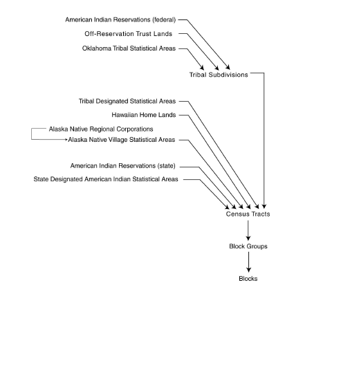
The smallest component for all census geography is the block. Figure 2-3 at the end of this chapter provides an example of the various geographic hierarchies used, building from the block. Take some time to review this chart to become familiar with the different hierarchies. Begin reading the schematic from the bottom at the blocks entry. By following the lines you can see the hierarchy very quickly. For example, follow blocks to block groups, to census tracts, to counties. This path indicates that census tracts and its sublevels in the hierarchy are uniquely identified within a county and do not cross county boundaries.
Follow blocks to the school district hierarchy. This path tells you that school districts can cross jurisdictional boundaries, but do not cross state lines. Figure 2-4 at the end of this chapter presents similar information for the American Indian areas/Alaska Native area/Hawaiian home land hierarchy. Again, read the schematic from the bottom, beginning with the lowest level of geography.
Follow blocks to the school district hierarchy. This path tells you that school districts can cross jurisdictional boundaries, but do not cross state lines. Figure 2-4 at the end of this chapter presents similar information for the American Indian areas/Alaska Native area/Hawaiian home land hierarchy. Again, read the schematic from the bottom, beginning with the lowest level of geography.
The geographic header record, Figure 2-5 at the end of this chapter, define s each field provides its mnemonic, size, starting position, and data type. In addition, the information in each summary level column is a guide to the presence or absence of additional geographic information on that specific summary level. For example, on the column for summary level 040,we see X for the first 11 fields, indicating that there will be information for those fields. In the county field, there is no X indicating that there is no code for county in summary level 040. Since 040 is the summary level for state, this is perfectly logical.
In another example, we note the elementary school district field in the geographic header under Special Area Codes. In searching through the various summary levels of the header record, we see that the information (designated by an X in the field) is available only for summary level 750 (blocks within a hierarchy) and summary level 755 (blocks within a hierarchy for Puerto Rico).
In another example, we note the elementary school district field in the geographic header under Special Area Codes. In searching through the various summary levels of the header record, we see that the information (designated by an X in the field) is available only for summary level 750 (blocks within a hierarchy) and summary level 755 (blocks within a hierarchy for Puerto Rico).
File identification (FILEID),state/US abbreviation (STUSAB),summary levels (SUMLEV), and the geographic component codes (GEOCOMP) are critical elements in identifying the geographic level for each record. The STUSAB field identifies the highest level of geography for the file. In the case of state file, it identifies the individual state. For SF 1 files, the following FILEID and STUSAB codes are used:
SF 1 state and state equivalent files uSF1AL-WY
SF 1 advance national file uSF1AUS
SF 1 final national file uSF1FUS
SF 1 state and state equivalent files uSF1AL-WY
SF 1 advance national file uSF1AUS
SF 1 final national file uSF1FUS
The Summary Level Sequence Chart (Chapter 4) identifies each geographic level and provides the code that is in the SUMLEV field of the geographic header record. It is easy to determine the code for the desired geography if you remember that the last geographic area type listed in the sequence identifies the geography of the summary level; the prior codes simply identify the hierarchy. See the two examples below:
140 State-County-Census Tract
144 State-County-Census Tract-American Indian Area/Alaska Native Area/Hawaiian Home Land
In summary level 140,the record contains data for a census tract within a county within a state. Census tracts are uniquely numbered within a county and do not cross county boundaries. Since counties do not cross state boundaries,this is a simple application. Thus,summary level 140 provides data for a complete census tract. In summary level 144, the geography is more complex. The key is to work backward through the hierarchy. Thus, summary level 144 is a record for the portion of an American Indian Area (or
an Alaska Native Area or a Hawaiian Home Land) within a specific census tract within a county within a state.
When reading the Summary Level Sequence Chart, it is important to recognize that dashes (-) separate the individual hierarchies while slashes separate different types of geography (such as place/remainder) within the same hierarchy.
The segmentation information discussed here applies to the CD-ROM/DVD files, the FTP files downloaded from American FactFinder, and any CD-ROM files that are custom created by the Census Bureau.
It is important to have some clarification on definitions. The data for an individual state are known as the file set. This is the package that the CD-ROM for a state will contain. Because of the large size of the tables, the file set is broken into 40 files: a geographic header record file and 39 table files. Figure 2-2 provides the file/table details.
It is easiest to think of the file set as a logical file. However, this logical file consists of 40 physical files: the geographic header record file and file01 through file39. This file design is a change from census files from earlier decades. The larger size of the tables made this necessary. By offering smaller files, users can work only with the file containing the table they need. A unique logical record number (LOGRECNO in the geographic header record) is assigned to all files for a specific geographic entity. This is done so all records for that specific entity can be linked together across files. Besides the logical record number, other identifying fields are also carried over from the geographic header file to the table files. These are file identification (FILEID), state/U.S. abbreviation (STUSAB),characteristic iteration (CHARITER),and characteristic iteration file sequence number (CIFSN).
See Figure 2-1 below for geographic header record information for FILE 01-FILE 39.
See Figure 2-1 below for geographic header record information for FILE 01-FILE 39.
The geographic header record is standard across all electronic data products from Census 2000. It is in a fixed field format as described in the data dictionary. However,when geographic header fields are used to provide geographic linkage across files in files 01-39, they are in the same format as the rest of the file-comma delimited.
Since SF 1 files are relatively simple,many of the fields,including some header fields that appear in all 40 files (geographic header and 39 table files) are not used. For example, the characteristic iteration (CHARITER) field is only used in Summary Files 2 and 4. In SF 1,it is always coded as 000.
Figure 2-3. Hierarchical Relationship of Census Geographic Entities

Figure 2-4. American Indian Area/Alaska Native Area/Hawaiian Home Land Hierarchy
It is important to have some clarification on definitions. The data for an individual state are known as the file set. This is the package that the CD-ROM for a state will contain. Because of the large size of the tables, the file set is broken into 40 files: a geographic header record file and 39 table files. Figure 2-2 provides the file/table details.
It is easiest to think of the file set as a logical file. However, this logical file consists of 40 physical files: the geographic header record file and file01 through file39. This file design is a change from census files from earlier decades. The larger size of the tables made this necessary. By offering smaller files, users can work only with the file containing the table they need. A unique logical record number (LOGRECNO in the geographic header record) is assigned to all files for a specific geographic entity. This is done so all records for that specific entity can be linked together across files. Besides the logical record number, other identifying fields are also carried over from the geographic header file to the table files. These are file identification (FILEID), state/U.S. abbreviation (STUSAB),characteristic iteration (CHARITER),and characteristic iteration file sequence number (CIFSN).
See Figure 2-1 below for geographic header record information for FILE 01-FILE 39.
See Figure 2-1 below for geographic header record information for FILE 01-FILE 39.
| Figure 2-1. File Set Structure Schematic | |||
|---|---|---|---|
| Geographic header record file | File 01 | File 02 | Files 03-39 |
| Record 1 | |||
| FILEID | FILEID | FILEID | Link fields shown on Files 01 and 02 are repeated for all files |
| STUSAB | STUSAB | STUSAB | |
| CHARITER | CHARITER | CHARITER | |
| CIFSN | CIFSN | CIFSN | |
| LOGRECNO | LOGRECNO | LOGRECNO | |
| (Record 1) | (Record 1) | (Record 1) | |
| Remainder of geographic header record for geographic area x | Tables P1-P5 (222 cells) | Tables P6-P18 (238 cells) | See Figure 2-2 for distribution of the tables across files |
| Record 2 | |||
| FILEID | FILEID | FILEID | Link fields shown on Files 01 and 02 are repeated for all files |
| STUSAB | STUSAB | STUSAB | |
| CHARITER | CHARITER | CHARITER | |
| CIFSN | CIFSN | CIFSN | |
| LOGRECNO | LOGRECNO | LOGRECNO | |
| (Record 2) | (Record 2) | (Record 2) | |
| Remainder of geographic header record for geographic area y | Tables P1-P5 (222 cells) | Tables P6-P18 (238 cells) | See Figure 2-2 for distribution of the tables across files |
| Record 3 | |||
| FILEID | FILEID | FILEID | Link fields shown on Files 01 and 02 are repeated for all files |
| STUSAB | STUSAB | STUSAB | |
| CHARITER | CHARITER | CHARITER | |
| CIFSN | CIFSN | CIFSN | |
| LOGRECNO | LOGRECNO | LOGRECNO | |
| (Record 3) | (Record 3) | (Record 3) | |
| Geographic header record for geographic area z | Tables P1-P5 (222 cells) | Tables P6-P18 (238 cells) | See Figure 2-2 for distribution of the tables across files |
The geographic header record is standard across all electronic data products from Census 2000. It is in a fixed field format as described in the data dictionary. However,when geographic header fields are used to provide geographic linkage across files in files 01-39, they are in the same format as the rest of the file-comma delimited.
Since SF 1 files are relatively simple,many of the fields,including some header fields that appear in all 40 files (geographic header and 39 table files) are not used. For example, the characteristic iteration (CHARITER) field is only used in Summary Files 2 and 4. In SF 1,it is always coded as 000.
| Figure 2-2. File/Table Segmentation | |||
|---|---|---|---|
| Geographic header file name | Number of data items | Starting matrix number | Ending matrix number |
| 011 | 222 | P1 | P5 |
| 02 | 238 | P6 | P18 |
| 03 | 236 | P19 | P33 |
| 04 | 149 | P34 | P45 |
| 05 | 245 | P12A | P12E |
| 06 | 241 | P12F | P16I |
| 07 | 234 | P17A | P27C |
| 08 | 247 | P27D | P28E |
| 09 | 244 | P28F | P30H |
| 10 | 229 | P30I | P34I |
| 11 | 180 | P35A | P35I |
| 12 | 235 | PCT1 | PCT9 |
| 13 | 45 | PCT10 | PCT11 |
| 14 | 209 | PCT12 | PCT12 |
| 15 | 196 | PCT13 | PCT17 |
| 16 | 209 | PCT12A | PCT12A |
| 17 | 209 | PCT12B | PCT12B |
| 18 | 209 | PCT12C | PCT12C |
| 19 | 209 | PCT12D | PCT12D |
| 20 | 209 | PCT12E | PCT12E |
| 21 | 209 | PCT12F | PCT12F |
| 22 | 209 | PCT12G | PCT12G |
| 23 | 209 | PCT12H | PCT12H |
| 24 | 209 | PCT12I | PCT12I |
| 25 | 209 | PCT12J | PCT12J |
| 26 | 209 | PCT12K | PCT12K |
| 27 | 209 | PCT12L | PCT12L |
| 28 | 209 | PCT12M | PCT12M |
| 29 | 209 | PCT12N | PCT12N |
| 30 | 209 | PCT12O | PCT12O |
| 31 | 245 | PCT13A | PCT13E |
| 32 | 235 | PCT13F | PCT15C |
| 33 | 228 | PCT15D | PCT17B |
| 34 | 225 | PCT17C | PCT17E |
| 35 | 225 | PCT17F | PCT17H |
| 36 | 75 | PCT17I | PCT17I |
| 37 | 217 | H1 | H20 |
| 38 | 207 | H11A | H15I |
| 39 | 171 | H16A | H16I |
Figure 2-3. Hierarchical Relationship of Census Geographic Entities
Figure 2-4. American Indian Area/Alaska Native Area/Hawaiian Home Land Hierarchy
| Figure 2-5. Geographic Header Record | ||||||||||
|---|---|---|---|---|---|---|---|---|---|---|
| Summary File 1 State File | ||||||||||
| Field | Data dictionary reference name | Field size | Starting position | Data type | Summary levels | |||||
| 040 | 050 | 060 | 067 | 070 | 080 | |||||
| RECORD CODES | ||||||||||
| File Identification | FILEID | 6 | 1 | A/N | X | X | X | X | X | X |
| State/US-Abbreviation (USPS) | STUSAB | 2 | 7 | A | X | X | X | X | X | X |
| Summary Level | SUMLEV | 3 | 9 | N | X | X | X | X | X | X |
| Geographic Component | GEOCOMP | 2 | 12 | A/N | X | X | X | X | X | X |
| Characteristic Iteration | CHARITER | 3 | 14 | A/N | X | X | X | X | X | X |
| Characteristic Iteration File Sequence Number | CIFSN | 2 | 17 | A/N | X | X | X | X | X | X |
| Logical Record Number | LOGRECNO | 7 | 19 | N | X | X | X | X | X | X |
| GEOGRAPHIC AREA CODES | ||||||||||
| Region | REGION | 1 | 26 | A/N | X | X | X | X | X | X |
| Division | DIVISION | 1 | 27 | A/N | X | X | X | X | X | X |
| State (Census) | STATECE | 2 | 28 | A/N | X | X | X | X | X | X |
| State (FIPS) | STATE | 2 | 30 | A/N | X | X | X | X | X | X |
| County | COUNTY | 3 | 32 | A/N | X | X | X | X | X | |
| County Size Code | COUNTYSC | 2 | 35 | A/N | X | X | X | X | X | |
| County Subdivision (FIPS) | COUSUB | 5 | 37 | A/N | X | X | X | X | ||
| FIPS County Subdivision Class Code | COUSUBCC | 2 | 42 | A/N | X | X | X | X | ||
| County Subdivision Size Code | COUSUBSC | 2 | 44 | A/N | X | X | X | X | ||
| Place (FIPS) | PLACE | 5 | 46 | A/N | X | X | ||||
| FIPS Place Class Code | PLACECC | 2 | 51 | A/N | X | X | ||||
| Place Description Code | PLACEDC | 1 | 53 | A/N | X | X | X | X | X | |
| Place Size Code | PLACESC | 2 | 54 | A/N | X | X | ||||
| Census Tract | TRACT | 6 | 56 | A/N | X | |||||
| Block Group | BLKGRP | 1 | 62 | A/N | ||||||
| Block | BLOCK | 4 | 63 | A/N | ||||||
| Internal Use Code | IUC | 2 | 67 | A/N | ||||||
| Consolidated City (FIPS) | CONCIT | 5 | 69 | A/N | ||||||
| FIPS Consolidated City Class Code | CONCITCC | 2 | 74 | A/N | ||||||
| Consolidated City Size Code | CONCITSC | 2 | 76 | A/N | ||||||
| American Indian Area/Alaska Native Area/Hawaiian Home Land (Census) | AIANHH | 4 | 78 | A/N | ||||||
| American Indian Area/Alaska Native Area/Hawaiian Home Land (FIPS) | AIANHHFP | 5 | 82 | A/N | ||||||
| FIPS American Indian Area/Alaska Native Area/Hawaiian Home Land Class Code | AIANHHCC | 2 | 87 | A/N | ||||||
| American Indian Trust Land/Hawaiian Home Land Indicator | AIHHTLI | 1 | 89 | A/N | ||||||
| American Indian Tribal Subdivision (Census) | AITSCE | 3 | 90 | A/N | ||||||
| American Indian Tribal Subdivision (FIPS) | AITS | 5 | 93 | A/N | ||||||
| FIPS American Indian Tribal Subdivision Class Code | AITSCC | 2 | 98 | A/N | ||||||
| Alaska Native Regional Corporation (FIPS) | ANRC | 5 | 100 | A/N | ||||||
| FIPS Alaska Native Regional Corporation Class Code | ANRCCC | 2 | 105 | A/N | ||||||
| Metropolitan Statistical Area/Consolidated Metropolitan Statistical Area | MSACMSA | 4 | 107 | A/N | X | X | X | X | X | |
| MSA/CMSA Size Code | MASC | 2 | 111 | A/N | X | X | X | X | X | |
| Consolidated Metropolitan Statistical Area | CMSA | 2 | 113 | A/N | X | X | X | X | X | |
| Metropolitan Area Central City Indicator | MACCI | 1 | 115 | A/N | X | X | X | X | X | |
| Primary Metropolitan Statistical Area | PMSA | 4 | 116 | A/N | X | X | X | X | X | |
| New England County Metropolitan Area | NECMA | 4 | 120 | A/N | X | X | X | X | X | |
| Metropolitan Area Central City Indicator | NECMACCI | 1 | 124 | A/N | X | X | X | X | X | |
| New England County Metropolitan Area Size Code | NECMASC | 2 | 125 | A/N | X | X | X | X | X | |
| Extended Place Indicator | EXI | 1 | 127 | A/N | X | |||||
| Urban Area | UA | 5 | 128 | A/N | ||||||
| Urban Area Size Code | UASC | 2 | 133 | A/N | ||||||
| Urban Area Type | UATYPE | 1 | 135 | A/N | ||||||
| Urban/Rural | UR | 1 | 136 | A/N | ||||||
| Congressional District (106th) | CD106 | 2 | 137 | A/N | ||||||
| Congressional District (108th) | CD108 | 2 | 139 | A/N | ||||||
| Congressional District (109th) | CD109 | 2 | 141 | A/N | ||||||
| Congressional District (110th) | CD110 | 2 | 143 | A/N | ||||||
| State Legislative District (Upper Chamber) | SLDU | 3 | 145 | A/N | ||||||
| State Legislative District (Lower Chamber) | SLDL | 3 | 148 | A/N | ||||||
| Voting District | VTD | 6 | 151 | A/N | ||||||
| Voting District Indicator | VTDI | 1 | 157 | A/N | ||||||
| ZIP Code Tabulation Area (3 digit) | ZCTA3 | 3 | 158 | A/N | ||||||
| ZIP Code Tabulation Area (5 digit) | ZCTA5 | 5 | 161 | A/N | ||||||
| Subbarrio (FIPS) | SUBMCD | 5 | 166 | A/N | X | |||||
| FIPS Subbarrio Class Code | SUBMCDCC | 2 | 171 | A/N | X | |||||
| AREA CHARACTERISTICS | ||||||||||
| Area (Land) | AREALAND | 14 | 173 | A/N | X | X | X | X | X | X |
| Area (Water) | AREAWATR | 14 | 187 | A/N | X | X | X | X | X | X |
| Area Name - Legal/Statistical Area Description (LSAD) Term - Part Indicator | NAME | 90 | 201 | A/N | X | X | X | X | X | X |
| Functional Status Code | FUNCSTAT | 1 | 291 | A/N | X | X | X | X | X | X |
| Geographic Change User Note Indicator | GCUNI | 1 | 292 | A/N | X | X | X | X | X | |
| Population Count (100%) | POP100 | 9 | 293 | A/N | X | X | X | X | X | X |
| Housing Unit Count (100%) | HU100 | 9 | 302 | A/N | X | X | X | X | X | X |
| Internal Point (Latitude) | INTPTLAT | 9 | 311 | A/N | X | X | X | X | X | X |
| Internal Point (Longitude) | INTPTLON | 10 | 320 | A/N | X | X | X | X | X | X |
| Legal/Statistical Area Description Code | LSADC | 2 | 330 | A/N | X | X | X | X | X | |
| Part Flag | PARTFLAG | 1 | 332 | A/N | X | X | ||||
| SPECIAL AREA CODES | ||||||||||
| School District (Elementary) | SDELM | 5 | 333 | A/N | ||||||
| School District (Secondary) | SDSEC | 5 | 338 | A/N | ||||||
| School District (Unified) | SDUNI | 5 | 343 | A/N | ||||||
| Traffic Analysis Zone | TAZ | 6 | 348 | A/N | ||||||
| Oregon Urban Growth Area | UGA | 5 | 354 | A/N | ||||||
| Public Use Microdata Area - 5% File | PUMA5 | 5 | 359 | A/N | ||||||
| Public Use Microdata Area - 1% File | PUMA1 | 5 | 364 | A/N | ||||||
| Reserved | RESERVE2 | 15 | 369 | A/N | ||||||
| Metropolitan Area Central City | MACC | 5 | 384 | A/N | ||||||
| Urban Area Central Place | UACP | 5 | 389 | A/N | ||||||
| Reserved | RESERVED | 7 | 394 | A/N | ||||||
| Field | Data dictionary reference name | Field size | Starting position | Data type | Summary levels | |||||
|---|---|---|---|---|---|---|---|---|---|---|
| 091 | 101 | 140 | 144 | 150 | 154 | |||||
| RECORD CODES | ||||||||||
| File Identification | FILEID | 6 | 1 | A/N | X | X | X | X | X | X |
| State/US-Abbreviation (USPS) | STUSAB | 2 | 7 | A | X | X | X | X | X | X |
| Summary Level | SUMLEV | 3 | 9 | N | X | X | X | X | X | X |
| Geographic Component | GEOCOMP | 2 | 12 | A/N | X | X | X | X | X | X |
| Characteristic Iteration | CHARITER | 3 | 14 | A/N | X | X | X | X | X | X |
| Characteristic Iteration File Sequence Number | CIFSN | 2 | 17 | A/N | X | X | X | X | X | X |
| Logical Record Number | LOGRECNO | 7 | 19 | N | X | X | X | X | X | X |
| GEOGRAPHIC AREA CODES | ||||||||||
| Region | REGION | 1 | 26 | A/N | X | X | X | X | X | X |
| Division | DIVISION | 1 | 27 | A/N | X | X | X | X | X | X |
| State (Census) | STATECE | 2 | 28 | A/N | X | X | X | X | X | X |
| State (FIPS) | STATE | 2 | 30 | A/N | X | X | X | X | X | X |
| County | COUNTY | 3 | 32 | A/N | X | X | X | X | X | X |
| County Size Code | COUNTYSC | 2 | 35 | A/N | X | X | X | X | X | X |
| County Subdivision (FIPS) | COUSUB | 5 | 37 | A/N | X | X | ||||
| FIPS County Subdivision Class Code | COUSUBCC | 2 | 42 | A/N | X | X | ||||
| County Subdivision Size Code | COUSUBSC | 2 | 44 | A/N | X | X | ||||
| Place (FIPS) | PLACE | 5 | 46 | A/N | X | X | ||||
| FIPS Place Class Code | PLACECC | 2 | 51 | A/N | X | X | ||||
| Place Description Code | PLACEDC | 1 | 53 | A/N | X | X | X | X | X | X |
| Place Size Code | PLACESC | 2 | 54 | A/N | X | X | ||||
| Census Tract | TRACT | 6 | 56 | A/N | X | X | X | X | X | X |
| Block Group | BLKGRP | 1 | 62 | A/N | X | X | X | X | ||
| Block | BLOCK | 4 | 63 | A/N | X | |||||
| Internal Use Code | IUC | 2 | 67 | A/N | ||||||
| Consolidated City (FIPS) | CONCIT | 5 | 69 | A/N | X | |||||
| FIPS Consolidated City Class Code | CONCITCC | 2 | 74 | A/N | X | |||||
| Consolidated City Size Code | CONCITSC | 2 | 76 | A/N | X | |||||
| American Indian Area/Alaska Native Area/Hawaiian Home Land (Census) | AIANHH | 4 | 78 | A/N | X | X | X | |||
| American Indian Area/Alaska Native Area/Hawaiian Home Land (FIPS) | AIANHHFP | 5 | 82 | A/N | X | X | X | |||
| FIPS American Indian Area/Alaska Native Area/Hawaiian Home Land Class Code | AIANHHCC | 2 | 87 | A/N | X | X | X | |||
| American Indian Trust Land/Hawaiian Home Land Indicator | AIHHTLI | 1 | 89 | A/N | X | X | X | |||
| American Indian Tribal Subdivision (Census) | AITSCE | 3 | 90 | A/N | X | |||||
| American Indian Tribal Subdivision (FIPS) | AITS | 5 | 93 | A/N | X | |||||
| FIPS American Indian Tribal Subdivision Class Code | AITSCC | 2 | 98 | A/N | X | |||||
| Alaska Native Regional Corporation (FIPS) | ANRC | 5 | 100 | A/N | X | |||||
| FIPS Alaska Native Regional Corporation Class Code | ANRCCC | 2 | 105 | A/N | X | |||||
| Metropolitan Statistical Area/Consolidated Metropolitan Statistical Area | MSACMSA | 4 | 107 | A/N | X | X | X | X | X | X |
| MSA/CMSA Size Code | MASC | 2 | 111 | A/N | X | X | X | X | X | X |
| Consolidated Metropolitan Statistical Area | CMSA | 2 | 113 | A/N | X | X | X | X | X | X |
| Metropolitan Area Central City | ||||||||||
| Indicator | MACCI | 1 | 115 | A/N | X | X | X | X | X | X |
| Primary Metropolitan Statistical Area | PMSA | 4 | 116 | A/N | X | X | X | X | X | X |
| New England County Metropolitan Area | NECMA | 4 | 120 | A/N | X | X | X | X | X | X |
| New England County Metropolitan Area Central City Indicator | NECMACCI | 1 | 124 | A/N | X | X | X | X | X | X |
| New England County Metropolitan Area Size Code | NECMASC | 2 | 125 | A/N | X | X | X | X | X | X |
| Extended Place Indicator | EXI | 1 | 127 | A/N | ||||||
| Urban Area | UA | 5 | 128 | A/N | ||||||
| Urban Area Size Code | UASC | 2 | 133 | A/N | ||||||
| Urban Area Type | UATYPE | 1 | 135 | A/N | ||||||
| Urban/Rural | UR | 1 | 136 | A/N | ||||||
| Congressional District (106th) | CD106 | 2 | 137 | A/N | X | |||||
| Congressional District (108th) | CD108 | 2 | 139 | A/N | ||||||
| Congressional District (109th) | CD109 | 2 | 141 | A/N | ||||||
| Congressional District (110th) | CD110 | 2 | 143 | A/N | ||||||
| State Legislative District (Upper Chamber) | SLDU | 3 | 145 | A/N | X | |||||
| State Legislative District (Lower Chamber) | SLDL | 3 | 148 | A/N | X | |||||
| Voting District | VTD | 6 | 151 | A/N | X | |||||
| Voting District Indicator | VTDI | 1 | 157 | A/N | X | |||||
| ZIP Code Tabulation Area (3 digit) | ZCTA3 | 3 | 158 | A/N | X | |||||
| ZIP Code Tabulation Area (5 digit) | ZCTA5 | 5 | 161 | A/N | X | |||||
| Subbarrio (FIPS) | SUBMCD | 5 | 166 | A/N | X | |||||
| FIPS Subbarrio Class Code | SUBMCDCC | 2 | 171 | A/N | X | |||||
| AREA CHARACTERISTICS | ||||||||||
| Area (Land) | AREALAND | 14 | 173 | A/N | X | X | X | X | X | X |
| Area (Water) | AREAWATR | 14 | 187 | A/N | X | X | X | X | X | X |
| Area Name - Legal/Statistical Area Description (LSAD)Term - Part Indicator | NAME | 90 | 201 | A/N | X | X | X | X | X | X |
| Functional Status Code | FUNCSTAT | 1 | 291 | A/N | X | X | X | X | X | X |
| Geographic Change User Note Indicator | GCUNI | 1 | 292 | A/N | X | X | ||||
| Population Count (100%) | POP100 | 9 | 293 | A/N | X | X | X | X | X | X |
| Housing Unit Count (100%) | HU100 | 9 | 302 | A/N | X | X | X | X | X | X |
| Internal Point (Latitude) | INTPTLAT | 9 | 311 | A/N | X | X | X | X | X | X |
| Internal Point (Longitude) | INTPTLON | 10 | 320 | A/N | X | X | X | X | X | X |
| Legal/Statistical Area Description Code | LSADC | 2 | 330 | A/N | X | X | ||||
| Part Flag | PARTFLAG | 1 | 332 | A/N | X | X | X | |||
| SPECIAL AREA CODES | ||||||||||
| School District (Elementary) | SDELM | 5 | 333 | A/N | X | |||||
| School District (Secondary) | SDSEC | 5 | 338 | A/N | X | |||||
| School District (Unified) | SDUNI | 5 | 343 | A/N | X | |||||
| Traffic Analysis Zone | TAZ | 6 | 348 | A/N | X | |||||
| Oregon Urban Growth Area | UGA | 5 | 354 | A/N | X | |||||
| Public Use Microdata Area - 5% File | PUMA5 | 5 | 359 | A/N | ||||||
| Public Use Microdata Area - 1% File | PUMA1 | 5 | 364 | A/N | ||||||
| Reserved | RESERVE2 | 15 | 369 | A/N | ||||||
| Metropolitan Area Central City | MACC | 5 | 384 | A/N | X | |||||
| Urban Area Central Place | UACP | 5 | 389 | A/N | ||||||
| Reserved | RESERVED | 7 | 394 | A/N | ||||||
| Field | Data dictionary reference name | Field size | Starting position | Data type | Summary levels | |||||
|---|---|---|---|---|---|---|---|---|---|---|
| 155 | 158 | 160 | 170 | 172 | 230 | |||||
| RECORD CODES | ||||||||||
| File Identification | FILEID | 6 | 1 | A/N | X | X | X | X | X | X |
| State/US-Abbreviation (USPS) | STUSAB | 2 | 7 | A | X | X | X | X | X | X |
| Summary Level | SUMLEV | 3 | 9 | N | X | X | X | X | X | X |
| Geographic Component | GEOCOMP | 2 | 12 | A/N | X | X | X | X | X | X |
| Characteristic Iteration | CHARITER | 3 | 14 | A/N | X | X | X | X | X | X |
| Characteristic Iteration File Sequence Number | CIFSN | 2 | 17 | A/N | X | X | X | X | X | X |
| Logical Record Number | LOGRECNO | 7 | 19 | N | X | X | X | X | X | X |
| GEOGRAPHIC AREA CODES | ||||||||||
| Region | REGION | 1 | 26 | A/N | X | X | X | X | X | X |
| Division | DIVISION | 1 | 27 | A/N | X | X | X | X | X | X |
| State (Census) | STATECE | 2 | 28 | A/N | X | X | X | X | X | X |
| State (FIPS) | STATE | 2 | 30 | A/N | X | X | X | X | X | X |
| County | COUNTY | 3 | 32 | A/N | X | X | ||||
| County Size Code | COUNTYSC | 2 | 35 | A/N | X | X | ||||
| County Subdivision (FIPS) | COUSUB | 5 | 37 | A/N | ||||||
| FIPS County Subdivision Class Code | COUSUBCC | 2 | 42 | A/N | ||||||
| County Subdivision Size Code | COUSUBSC | 2 | 44 | A/N | ||||||
| Place (FIPS) | PLACE | 5 | 46 | A/N | X | X | X | X | ||
| FIPS Place Class Code | PLACECC | 2 | 51 | A/N | X | X | X | X | ||
| Place Description Code | PLACEDC | 1 | 53 | A/N | X | X | X | X | X | |
| Place Size Code | PLACESC | 2 | 54 | A/N | X | X | X | X | ||
| Census Tract | TRACT | 6 | 56 | A/N | X | |||||
| Block Group | BLKGRP | 1 | 62 | A/N | ||||||
| Block | BLOCK | 4 | 63 | A/N | ||||||
| Internal Use Code | IUC | 2 | 67 | A/N | ||||||
| Consolidated City (FIPS) | CONCIT | 5 | 69 | A/N | X | X | ||||
| FIPS Consolidated City Class Code | CONCITCC | 2 | 74 | A/N | X | X | ||||
| Consolidated City Size Code | CONCITSC | 2 | 76 | A/N | X | X | ||||
| American Indian Area/Alaska Native Area/Hawaiian Home Land (Census) | AIANHH | 4 | 78 | A/N | ||||||
| American Indian Area/Alaska Native Area/Hawaiian Home Land (FIPS) | AIANHHFP | 5 | 82 | A/N | ||||||
| FIPS American Indian Area/Alaska Native Area/Hawaiian Home Land Class Code | AIANHHCC | 2 | 87 | A/N | ||||||
| American Indian Trust Land/Hawaiian Home Land Indicator | AIHHTLI | 1 | 89 | A/N | ||||||
| American Indian Tribal Subdivision (Census) | AITSCE | 3 | 90 | A/N | ||||||
| American Indian Tribal Subdivision (FIPS) | AITS | 5 | 93 | A/N | ||||||
| FIPS American Indian Tribal Subdivision Class Code | AITSCC | 2 | 98 | A/N | ||||||
| Alaska Native Regional Corporation (FIPS) | ANRC | 5 | 100 | A/N | X | |||||
| FIPS Alaska Native Regional Corporation Class Code | ANRCCC | 2 | 105 | A/N | X | |||||
| Metropolitan Statistical Area/Consolidated Metropolitan Statistical Area | MSACMSA | 4 | 107 | A/N | X | X | X | X | X | |
| MSA/CMSA Size Code | MASC | 2 | 111 | A/N | X | X | X | X | X | |
| Consolidated Metropolitan Statistical Area | CMSA | 2 | 113 | A/N | X | X | X | X | X | |
| Metropolitan Area Central City | ||||||||||
| Indicator | MACCI | 1 | 115 | A/N | X | X | X | X | X | |
| Primary Metropolitan Statistical Area | PMSA | 4 | 116 | A/N | X | X | X | X | X | |
| New England County Metropolitan Area | NECMA | 4 | 120 | A/N | X | X | X | X | X | |
| New England County Metropolitan Area Central City Indicator | NECMACCI | 1 | 124 | A/N | X | X | X | X | X | |
| New England County Metropolitan Area Size Code | NECMASC | 2 | 125 | A/N | X | X | X | X | X | |
| Extended Place Indicator | EXI | 1 | 127 | A/N | X | X | X | |||
| Urban Area | UA | 5 | 128 | A/N | ||||||
| Urban Area Size Code | UASC | 2 | 133 | A/N | ||||||
| Urban Area Type | UATYPE | 1 | 135 | A/N | ||||||
| Urban/Rural | UR | 1 | 136 | A/N | ||||||
| Congressional District (106th) | CD106 | 2 | 137 | A/N | ||||||
| Congressional District (108th) | CD108 | 2 | 139 | A/N | ||||||
| Congressional District (109th) | CD109 | 2 | 141 | A/N | ||||||
| Congressional District (110th) | CD110 | 2 | 143 | A/N | ||||||
| State Legislative District (Upper Chamber) | SLDU | 3 | 145 | A/N | ||||||
| State Legislative District (Lower Chamber) | SLDL | 3 | 148 | A/N | ||||||
| Voting District | VTD | 6 | 151 | A/N | ||||||
| Voting District Indicator | VTDI | 1 | 157 | A/N | ||||||
| ZIP Code Tabulation Area (3 digit) | ZCTA3 | 3 | 158 | A/N | ||||||
| ZIP Code Tabulation Area (5 digit) | ZCTA5 | 5 | 161 | A/N | ||||||
| Subbarrio (FIPS) | SUBMCD | 5 | 166 | A/N | ||||||
| FIPS Subbarrio Class Code | SUBMCDCC | 2 | 171 | A/N | ||||||
| AREA CHARACTERISTICS | ||||||||||
| Area (Land) | AREALAND | 14 | 173 | A/N | X | X | X | X | X | X |
| Area (Water) | AREAWATR | 14 | 187 | A/N | X | X | X | X | X | X |
| Area Name - Legal/Statistical Area Description (LSAD)Term - Part Indicator | NAME | 90 | 201 | A/N | X | X | X | X | X | X |
| Functional Status Code | FUNCSTAT | 1 | 291 | A/N | X | X | X | X | X | X |
| Geographic Change User Note Indicator | GCUNI | 1 | 292 | A/N | X | X | X | X | X | |
| Population Count (100%) | POP100 | 9 | 293 | A/N | X | X | X | X | X | X |
| Housing Unit Count (100%) | HU100 | 9 | 302 | A/N | X | X | X | X | X | X |
| Internal Point (Latitude) | INTPTLAT | 9 | 311 | A/N | X | X | X | X | X | X |
| Internal Point (Longitude) | INTPTLON | 10 | 320 | A/N | X | X | X | X | X | X |
| Legal/Statistical Area Description Code | LSADC | 2 | 330 | A/N | X | X | X | X | X | |
| Part Flag | PARTFLAG | 1 | 332 | A/N | X | X | X | |||
| SPECIAL AREA CODES | ||||||||||
| School District (Elementary) | SDELM | 5 | 333 | A/N | ||||||
| School District (Secondary) | SDSEC | 5 | 338 | A/N | ||||||
| School District (Unified) | SDUNI | 5 | 343 | A/N | ||||||
| Traffic Analysis Zone | TAZ | 6 | 348 | A/N | ||||||
| Oregon Urban Growth Area | UGA | 5 | 354 | A/N | ||||||
| Public Use Microdata Area - 5% File | PUMA5 | 5 | 359 | A/N | ||||||
| Public Use Microdata Area - 1% File | PUMA1 | 5 | 364 | A/N | ||||||
| Reserved | RESERVE2 | 15 | 369 | A/N | ||||||
| Metropolitan Area Central City | MACC | 5 | 384 | A/N | ||||||
| Urban Area Central Place | UACP | 5 | 389 | A/N | ||||||
| Reserved | RESERVED | 7 | 394 | A/N | ||||||
| Field | Data dictionary reference name | Field size | Starting position | Data type | Summary levels | |||||
|---|---|---|---|---|---|---|---|---|---|---|
| 261 | 263 | 265 | 266 | 267 | 268 | |||||
| RECORD CODES | ||||||||||
| File Identification | FILEID | 6 | 1 | A/N | X | X | X | X | X | X |
| State/US-Abbreviation (USPS) | STUSAB | 2 | 7 | A | X | X | X | X | X | X |
| Summary Level | SUMLEV | 3 | 9 | N | X | X | X | X | X | X |
| Geographic Component | GEOCOMP | 2 | 12 | A/N | X | X | X | X | X | X |
| Characteristic Iteration | CHARITER | 3 | 14 | A/N | X | X | X | X | X | X |
| Characteristic Iteration File Sequence Number | CIFSN | 2 | 17 | A/N | X | X | X | X | X | X |
| Logical Record Number | LOGRECNO | 7 | 19 | N | X | X | X | X | X | X |
| GEOGRAPHIC AREA CODES | ||||||||||
| Region | REGION | 1 | 26 | A/N | X | X | X | X | X | X |
| Division | DIVISION | 1 | 27 | A/N | X | X | X | X | X | X |
| State (Census) | STATECE | 2 | 28 | A/N | X | X | X | X | X | X |
| State (FIPS) | STATE | 2 | 30 | A/N | X | X | X | X | X | X |
| County | COUNTY | 3 | 32 | A/N | X | X | X | X | X | X |
| County Size Code | COUNTYSC | 2 | 35 | A/N | X | X | X | X | X | X |
| County Subdivision (FIPS) | COUSUB | 5 | 37 | A/N | X | X | X | X | X | X |
| FIPS County Subdivision Class Code | COUSUBCC | 2 | 42 | A/N | X | X | X | X | X | X |
| County Subdivision Size Code | COUSUBSC | 2 | 44 | A/N | X | X | X | X | X | X |
| Place (FIPS) | PLACE | 5 | 46 | A/N | X | X | X | |||
| FIPS Place Class Code | PLACECC | 2 | 51 | A/N | X | X | X | |||
| Place Description Code | PLACEDC | 1 | 53 | A/N | X | X | X | X | X | X |
| Place Size Code | PLACESC | 2 | 54 | A/N | X | X | X | |||
| Census Tract | TRACT | 6 | 56 | A/N | ||||||
| Block Group | BLKGRP | 1 | 62 | A/N | ||||||
| Block | BLOCK | 4 | 63 | A/N | ||||||
| Internal Use Code | IUC | 2 | 67 | A/N | ||||||
| Consolidated City (FIPS) | CONCIT | 5 | 69 | A/N | ||||||
| FIPS Consolidated City Class Code | CONCITCC | 2 | 74 | A/N | ||||||
| Consolidated City Size Code | CONCITSC | 2 | 76 | A/N | ||||||
| American Indian Area/Alaska Native Area/Hawaiian Home Land (Census) | AIANHH | 4 | 78 | A/N | X | X | X | X | X | X |
| American Indian Area/Alaska Native Area/Hawaiian Home Land (FIPS) | AIANHHFP | 5 | 82 | A/N | X | X | X | X | X | X |
| FIPS American Indian Area/Alaska Native Area/Hawaiian Home Land Class Code | AIANHHCC | 2 | 87 | A/N | X | X | X | X | X | X |
| American Indian Trust Land/Hawaiian Home Land Indicator | AIHHTLI | 1 | 89 | A/N | X | X | X | X | X | X |
| American Indian Tribal Subdivision (Census) | AITSCE | 3 | 90 | A/N | ||||||
| American Indian Tribal Subdivision (FIPS) | AITS | 5 | 93 | A/N | ||||||
| FIPS American Indian Tribal Subdivision Class Code | AITSCC | 2 | 98 | A/N | ||||||
| Alaska Native Regional Corporation (FIPS) | ANRC | 5 | 100 | A/N | ||||||
| FIPS Alaska Native Regional Corporation Class Code | ANRCCC | 2 | 105 | A/N | ||||||
| Metropolitan Statistical Area/Consolidated Metropolitan Statistical Area | MSACMSA | 4 | 107 | A/N | X | X | X | X | X | X |
| MSA/CMSA Size Code | MASC | 2 | 111 | A/N | X | X | X | X | X | X |
| Consolidated Metropolitan Statistical Area | CMSA | 2 | 113 | A/N | X | X | X | X | X | X |
| Metropolitan Area Central City Indicator | MACCI | 1 | 115 | A/N | X | X | X | X | X | X |
| Primary Metropolitan Statistical Area | PMSA | 4 | 116 | A/N | X | X | X | X | X | X |
| New England County Metropolitan Area | NECMA | 4 | 120 | A/N | X | X | X | X | X | X |
| New England County Metropolitan Area Central City Indicator | NECMACCI | 1 | 124 | A/N | x | X | X | X | X | X |
| New England County Metropolitan Area Size Code | NECMASC | 2 | 125 | A/N | X | X | X | X | X | X |
| Extended Place Indicator | EXI | 1 | 127 | A/N | X | X | X | |||
| Urban Area | UA | 5 | 128 | A/N | ||||||
| Urban Area Size Code | UASC | 2 | 133 | A/N | ||||||
| Urban Area Type | UATYPE | 1 | 135 | A/N | ||||||
| Urban/Rural | UR | 1 | 136 | A/N | ||||||
| Congressional District (106th) | CD106 | 2 | 137 | A/N | ||||||
| Congressional District (108th) | CD108 | 2 | 139 | A/N | ||||||
| Congressional District (109th) | CD109 | 2 | 141 | A/N | ||||||
| Congressional District (110th) | CD110 | 2 | 143 | A/N | ||||||
| State Legislative District (Upper Chamber) | SLDU | 3 | 145 | A/N | ||||||
| State Legislative District (Lower Chamber) | SLDL | 3 | 148 | A/N | ||||||
| Voting District | VTD | 6 | 151 | A/N | ||||||
| Voting District Indicator | VTDI | 1 | 157 | A/N | ||||||
| ZIP Code Tabulation Area (3 digit) | ZCTA3 | 3 | 158 | A/N | ||||||
| ZIP Code Tabulation Area (5 digit) | ZCTA5 | 5 | 161 | A/N | ||||||
| Subbarrio (FIPS) | SUBMCD | 5 | 166 | A/N | ||||||
| FIPS Subbarrio Class Code | SUBMCDCC | 2 | 171 | A/N | ||||||
| AREA CHARACTERISTICS | ||||||||||
| Area (Land) | AREALAND | 14 | 173 | A/N | X | X | X | X | X | X |
| Area (Water) | AREAWATR | 14 | 187 | A/N | X | X | X | X | X | X |
| Area Name - Legal/Statistical Area Description (LSAD)Term - Part Indicator | NAME | 90 | 201 | A/N | X | X | X | X | X | X |
| Functional Status Code | FUNCSTAT | 1 | 291 | A/N | X | X | X | X | X | X |
| Geographic Change User Note Indicator | GCUNI | 1 | 292 | A/N | X | X | X | X | X | X |
| Population Count (100%) | POP100 | 9 | 293 | A/N | X | X | X | X | X | X |
| Housing Unit Count (100%) | HU100 | 9 | 302 | A/N | X | X | X | X | X | X |
| Internal Point (Latitude) | INTPTLAT | 9 | 311 | A/N | X | X | X | X | X | X |
| Internal Point (Longitude) | INTPTLON | 10 | 320 | A/N | X | X | X | X | X | X |
| Legal/Statistical Area Description Code | LSADC | 2 | 330 | A/N | X | X | X | X | X | X |
| Part Flag | PARTFLAG | 1 | 332 | A/N | X | X | X | X | X | X |
| SPECIAL AREA CODES | ||||||||||
| School District (Elementary) | SDELM | 5 | 333 | A/N | ||||||
| School District (Secondary) | SDSEC | 5 | 338 | A/N | ||||||
| School District (Unified) | SDUNI | 5 | 343 | A/N | ||||||
| Traffic Analysis Zone | TAZ | 6 | 348 | A/N | ||||||
| Oregon Urban Growth Area | UGA | 5 | 354 | A/N | ||||||
| Public Use Microdata Area - 5% File | PUMA5 | 5 | 359 | A/N | ||||||
| Public Use Microdata Area - 1% File | PUMA1 | 5 | 364 | A/N | ||||||
| Reserved | RESERVE2 | 15 | 369 | A/N | ||||||
| Metropolitan Area Central City | MACC | 5 | 384 | A/N | ||||||
| Urban Area Central Place | UACP | 5 | 389 | A/N | ||||||
| Reserved | RESERVED | 7 | 394 | A/N | ||||||
| Field | Data dictionary reference name | Field size | Starting position | Data type | Summary levels | |||||
|---|---|---|---|---|---|---|---|---|---|---|
| 280 | 281 | 282 | 283 | 284 | 285 | |||||
| RECORD CODES | ||||||||||
| File Identification | FILEID | 6 | 1 | A/N | X | X | X | X | X | X |
| State/US-Abbreviation (USPS) | STUSAB | 2 | 7 | A | X | X | X | X | X | X |
| Summary Level | SUMLEV | 3 | 9 | N | X | X | X | X | X | X |
| Geographic Component | GEOCOMP | 2 | 12 | A/N | X | X | X | X | X | X |
| Characteristic Iteration | CHARITER | 3 | 14 | A/N | X | X | X | X | X | X |
| Characteristic Iteration File Sequence Number | CIFSN | 2 | 17 | A/N | X | X | X | X | X | X |
| Logical Record Number | LOGRECNO | 7 | 19 | N | X | X | X | X | X | X |
| GEOGRAPHIC AREA CODES | ||||||||||
| Region | REGION | 1 | 26 | A/N | X | X | X | X | X | X |
| Division | DIVISION | 1 | 27 | A/N | X | X | X | X | X | X |
| State (Census) | STATECE | 2 | 28 | A/N | X | X | X | X | X | X |
| State (FIPS) | STATE | 2 | 30 | A/N | X | X | X | X | X | X |
| County | COUNTY | 3 | 32 | A/N | X | X | ||||
| County Size Code | COUNTYSC | 2 | 35 | A/N | X | X | ||||
| County Subdivision (FIPS) | COUSUB | 5 | 37 | A/N | ||||||
| FIPS County Subdivision Class Code | COUSUBCC | 2 | 42 | A/N | ||||||
| County Subdivision Size Code | COUSUBSC | 2 | 44 | A/N | ||||||
| Place (FIPS) | PLACE | 5 | 46 | A/N | ||||||
| FIPS Place Class Code | PLACECC | 2 | 51 | A/N | ||||||
| Place Description Code | PLACEDC | 1 | 53 | A/N | X | X | ||||
| Place Size Code | PLACESC | 2 | 54 | A/N | ||||||
| Census Tract | TRACT | 6 | 56 | A/N | ||||||
| Block Group | BLKGRP | 1 | 62 | A/N | ||||||
| Block | BLOCK | 4 | 63 | A/N | ||||||
| Internal Use Code | IUC | 2 | 67 | A/N | ||||||
| Consolidated City (FIPS) | CONCIT | 5 | 69 | A/N | ||||||
| FIPS Consolidated City Class Code | CONCITCC | 2 | 74 | A/N | ||||||
| Consolidated City Size Code | CONCITSC | 2 | 76 | A/N | ||||||
| American Indian Area/Alaska Native Area/Hawaiian Home Land (Census) | AIANHH | 4 | 78 | A/N | X | X | X | X | X | X |
| American Indian Area/Alaska Native Area/Hawaiian Home Land (FIPS) | AIANHHFP | 5 | 82 | A/N | X | X | X | X | X | X |
| FIPS American Indian Area/Alaska Native Area/Hawaiian Home Land Class Code | AIANHHCC | 2 | 87 | A/N | X | X | X | X | X | X |
| American Indian Trust Land/Hawaiian Home Land Indicator | AIHHTLI | 1 | 89 | A/N | X | X | X | X | X | X |
| American Indian Tribal Subdivision (Census) | AITSCE | 3 | 90 | A/N | X | X | ||||
| American Indian Tribal Subdivision (FIPS) | AITS | 5 | 93 | A/N | X | X | ||||
| FIPS American Indian Tribal Subdivision Class Code | AITSCC | 2 | 98 | A/N | X | X | ||||
| Alaska Native Regional Corporation (FIPS) | ANRC | 5 | 100 | A/N | ||||||
| FIPS Alaska Native Regional Corporation Class Code | ANRCCC | 2 | 105 | A/N | ||||||
| Metropolitan Statistical Area/Consolidated Metropolitan Statistical Area | MSACMSA | 4 | 107 | A/N | X | X | ||||
| MSA/CMSA Size Code | MASC | 2 | 111 | A/N | X | X | ||||
| Consolidated Metropolitan Statistical Area | CMSA | 2 | 113 | A/N | X | X | ||||
| Metropolitan Area Central City Indicator | MACCI | 1 | 115 | A/N | X | X | ||||
| Primary Metropolitan Statistical Area | PMSA | 4 | 116 | A/N | X | X | ||||
| New England County Metropolitan Area | NECMA | 4 | 120 | A/N | X | X | ||||
| New England County Metropolitan Area Central City Indicator | NECMACCI | 1 | 124 | A/N | X | X | ||||
| New England County Metropolitan Area Size Code | NECMASC | 2 | 125 | A/N | X | X | ||||
| Extended Place Indicator | EXI | 1 | 127 | A/N | ||||||
| Urban Area | UA | 5 | 128 | A/N | ||||||
| Urban Area Size Code | UASC | 2 | 133 | A/N | ||||||
| Urban Area Type | UATYPE | 1 | 135 | A/N | ||||||
| Urban/Rural | UR | 1 | 136 | A/N | ||||||
| Congressional District (106th) | CD106 | 2 | 137 | A/N | ||||||
| Congressional District (108th) | CD108 | 2 | 139 | A/N | ||||||
| Congressional District (109th) | CD109 | 2 | 141 | A/N | ||||||
| Congressional District (110th) | CD110 | 2 | 143 | A/N | ||||||
| State Legislative District (Upper Chamber) | SLDU | 3 | 145 | A/N | ||||||
| State Legislative District (Lower Chamber) | SLDL | 3 | 148 | A/N | ||||||
| Voting District | VTD | 6 | 151 | A/N | ||||||
| Voting District Indicator | VTDI | 1 | 157 | A/N | ||||||
| ZIP Code Tabulation Area (3 digit) | ZCTA3 | 3 | 158 | A/N | ||||||
| ZIP Code Tabulation Area (5 digit) | ZCTA5 | 5 | 161 | A/N | ||||||
| Subbarrio (FIPS) | SUBMCD | 5 | 166 | A/N | ||||||
| FIPS Subbarrio Class Code | SUBMCDCC | 2 | 171 | A/N | ||||||
| AREA CHARACTERISTICS | ||||||||||
| Area (Land) | AREALAND | 14 | 173 | A/N | X | X | X | X | X | X |
| Area (Water) | AREAWATR | 14 | 187 | A/N | X | X | X | X | X | X |
| Area Name - Legal/Statistical Area Description (LSAD)Term - Part Indicator | NAME | 90 | 201 | A/N | X | X | X | X | X | X |
| Functional Status Code | FUNCSTAT | 1 | 291 | A/N | X | X | X | X | X | X |
| Geographic Change User Note Indicator | GCUNI | 1 | 292 | A/N | X | X | X | X | X | X |
| Population Count (100%) | POP100 | 9 | 293 | A/N | X | X | X | X | X | X |
| Housing Unit Count (100%) | HU100 | 9 | 302 | A/N | X | X | X | X | X | X |
| Internal Point (Latitude) | INTPTLAT | 9 | 311 | A/N | X | X | X | X | X | X |
| Internal Point (Longitude) | INTPTLON | 10 | 320 | A/N | X | X | X | X | X | X |
| Legal/Statistical Area Description Code | LSADC | 2 | 330 | A/N | X | X | X | X | X | X |
| Part Flag | PARTFLAG | 1 | 332 | A/N | X | X | X | X | X | X |
| SPECIAL AREA CODES | ||||||||||
| School District (Elementary) | SDELM | 5 | 333 | A/N | ||||||
| School District (Secondary) | SDSEC | 5 | 338 | A/N | ||||||
| School District (Unified) | SDUNI | 5 | 343 | A/N | ||||||
| Traffic Analysis Zone | TAZ | 6 | 348 | A/N | ||||||
| Oregon Urban Growth Area | UGA | 5 | 354 | A/N | ||||||
| Public Use Microdata Area - 5% File | PUMA5 | 5 | 359 | A/N | ||||||
| Public Use Microdata Area - 1% File | PUMA1 | 5 | 364 | A/N | ||||||
| Reserved | RESERVE2 | 15 | 369 | A/N | ||||||
| Metropolitan Area Central City | MACC | 5 | 384 | A/N | ||||||
| Urban Area Central Place | UACP | 5 | 389 | A/N | ||||||
| Reserved | RESERVED | 7 | 394 | A/N | ||||||
| Field | Data dictionary reference name | Field size | Starting position | Data type | Summary levels | |||||
|---|---|---|---|---|---|---|---|---|---|---|
| 286 | 287 | 288 | 374 | 375 | 376 | |||||
| RECORD CODES | ||||||||||
| File Identification | FILEID | 6 | 1 | A/N | X | X | X | X | X | X |
| State/US-Abbreviation (USPS) | STUSAB | 2 | 7 | A | X | X | X | X | X | X |
| Summary Level | SUMLEV | 3 | 9 | N | X | X | X | X | X | X |
| Geographic Component | GEOCOMP | 2 | 12 | A/N | X | X | X | X | X | X |
| Characteristic Iteration | CHARITER | 3 | 14 | A/N | X | X | X | X | X | X |
| Characteristic Iteration File Sequence Number | CIFSN | 2 | 17 | A/N | X | X | X | X | X | X |
| Logical Record Number | LOGRECNO | 7 | 19 | N | X | X | X | X | X | X |
| GEOGRAPHIC AREA CODES | ||||||||||
| Region | REGION | 1 | 26 | A/N | X | X | X | X | X | X |
| Division | DIVISION | 1 | 27 | A/N | X | X | X | X | X | X |
| State (Census) | STATECE | 2 | 28 | A/N | X | X | X | X | X | X |
| State (FIPS) | STATE | 2 | 30 | A/N | X | X | X | X | X | X |
| County | COUNTY | 3 | 32 | A/N | X | X | ||||
| County Size Code | COUNTYSC | 2 | 35 | A/N | X | X | ||||
| County Subdivision (FIPS) | COUSUB | 5 | 37 | A/N | ||||||
| FIPS County Subdivision Class Code | COUSUBCC | 2 | 42 | A/N | ||||||
| County Subdivision Size Code | COUSUBSC | 2 | 44 | A/N | ||||||
| Place (FIPS) | PLACE | 5 | 46 | A/N | X | |||||
| FIPS Place Class Code | PLACECC | 2 | 51 | A/N | X | |||||
| Place Description Code | PLACEDC | 1 | 53 | A/N | X | X | X | |||
| Place Size Code | PLACESC | 2 | 54 | A/N | X | |||||
| Census Tract | TRACT | 6 | 56 | A/N | ||||||
| Block Group | BLKGRP | 1 | 62 | A/N | ||||||
| Block | BLOCK | 4 | 63 | A/N | ||||||
| Internal Use Code | IUC | 2 | 67 | A/N | ||||||
| Consolidated City (FIPS) | CONCIT | 5 | 69 | A/N | ||||||
| FIPS Consolidated City Class Code | CONCITCC | 2 | 74 | A/N | ||||||
| Consolidated City Size Code | CONCITSC | 2 | 76 | A/N | ||||||
| American Indian Area/Alaska Native Area/Hawaiian Home Land (Census) | AIANHH | 4 | 78 | A/N | X | X | X | |||
| American Indian Area/Alaska Native Area/Hawaiian Home Land (FIPS) | AIANHHFP | 5 | 82 | A/N | X | X | X | |||
| FIPS American Indian Area/Alaska Native Area/Hawaiian Home Land Class Code | AIANHHCC | 2 | 87 | A/N | X | X | X | |||
| American Indian Trust Land/Hawaiian Home Land Indicator | AIHHTLI | 1 | 89 | A/N | X | X | X | |||
| American Indian Tribal Subdivision (Census) | AITSCE | 3 | 90 | A/N | X | |||||
| American Indian Tribal Subdivision (FIPS) | AITS | 5 | 93 | A/N | X | |||||
| FIPS American Indian Tribal Subdivision Class Code | AITSCC | 2 | 98 | A/N | X | |||||
| Alaska Native Regional Corporation (FIPS) | ANRC | 5 | 100 | A/N | ||||||
| FIPS Alaska Native Regional Corporation Class Code | ANRCCC | 2 | 105 | A/N | ||||||
| Metropolitan Statistical Area/Consolidated Metropolitan Statistical Area | MSACMSA | 4 | 107 | A/N | X | |||||
| MSA/CMSA Size Code | MASC | 2 | 111 | A/N | X | |||||
| Consolidated Metropolitan Statistical Area | CMSA | 2 | 113 | A/N | X | |||||
| Metropolitan Area Central City Indicator | MACCI | 1 | 115 | A/N | X | |||||
| Primary Metropolitan Statistical Area | PMSA | 4 | 116 | A/N | X | |||||
| New England County Metropolitan Area | NECMA | 4 | 120 | A/N | X | X | X | X | ||
| New England County Metropolitan Area Central City Indicator | NECMACCI | 1 | 124 | A/N | X | X | X | |||
| New England County Metropolitan Area Size Code | NECMASC | 2 | 125 | A/N | X | X | X | X | ||
| Extended Place Indicator | EXI | 1 | 127 | A/N | X | |||||
| Urban Area | UA | 5 | 128 | A/N | ||||||
| Urban Area Size Code | UASC | 2 | 133 | A/N | ||||||
| Urban Area Type | UATYPE | 1 | 135 | A/N | ||||||
| Urban/Rural | UR | 1 | 136 | A/N | ||||||
| Congressional District (106th) | CD106 | 2 | 137 | A/N | ||||||
| Congressional District (108th) | CD108 | 2 | 139 | A/N | ||||||
| Congressional District (109th) | CD109 | 2 | 141 | A/N | ||||||
| Congressional District (110th) | CD110 | 2 | 143 | A/N | ||||||
| State Legislative District (Upper Chamber) | SLDU | 3 | 145 | A/N | ||||||
| State Legislative District (Lower Chamber) | SLDL | 3 | 148 | A/N | ||||||
| Voting District | VTD | 6 | 151 | A/N | ||||||
| Voting District Indicator | VTDI | 1 | 157 | A/N | ||||||
| ZIP Code Tabulation Area (3 digit) | ZCTA3 | 3 | 158 | A/N | ||||||
| ZIP Code Tabulation Area (5 digit) | ZCTA5 | 5 | 161 | A/N | ||||||
| Subbarrio (FIPS) | SUBMCD | 5 | 166 | A/N | ||||||
| FIPS Subbarrio Class Code | SUBMCDCC | 2 | 171 | A/N | ||||||
| AREA CHARACTERISTICS | ||||||||||
| Area (Land) | AREALAND | 14 | 173 | A/N | X | X | X | X | X | X |
| Area (Water) | AREAWATR | 14 | 187 | A/N | X | X | X | X | X | X |
| Area Name - Legal/Statistical Area Description (LSAD)Term - Part Indicator | NAME | 90 | 201 | A/N | X | X | X | X | X | X |
| Functional Status Code | FUNCSTAT | 1 | 291 | A/N | X | X | X | X | X | X |
| Geographic Change User Note Indicator | GCUNI | 1 | 292 | A/N | X | X | X | X | X | X |
| Population Count (100%) | POP100 | 9 | 293 | A/N | X | X | X | X | X | X |
| Housing Unit Count (100%) | HU100 | 9 | 302 | A/N | X | X | X | X | X | X |
| Internal Point (Latitude) | INTPTLAT | 9 | 311 | A/N | X | X | X | X | X | X |
| Internal Point (Longitude) | INTPTLON | 10 | 320 | A/N | X | X | X | X | X | X |
| Legal/Statistical Area Description Code | LSADC | 2 | 330 | A/N | X | X | X | X | X | X |
| Part Flag | PARTFLAG | 1 | 332 | A/N | X | X | X | X | X | |
| SPECIAL AREA CODES | ||||||||||
| School District (Elementary) | SDELM | 5 | 333 | A/N | ||||||
| School District (Secondary) | SDSEC | 5 | 338 | A/N | ||||||
| School District (Unified) | SDUNI | 5 | 343 | A/N | ||||||
| Traffic Analysis Zone | TAZ | 6 | 348 | A/N | ||||||
| Oregon Urban Growth Area | UGA | 5 | 354 | A/N | ||||||
| Public Use Microdata Area - 5% File | PUMA5 | 5 | 359 | A/N | ||||||
| Public Use Microdata Area - 1% File | PUMA1 | 5 | 364 | A/N | ||||||
| Reserved | RESERVE2 | 15 | 369 | A/N | ||||||
| Metropolitan Area Central City | MACC | 5 | 384 | A/N | X | |||||
| Urban Area Central Place | UACP | 5 | 389 | A/N | ||||||
| Reserved | RESERVED | 7 | 394 | A/N | ||||||
| Field | Data dictionary reference name | Field size | Starting position | Data type | Summary levels | |||||
|---|---|---|---|---|---|---|---|---|---|---|
| 390 | 391 | 392 | 393 | 395 | 396 | |||||
| RECORD CODES | ||||||||||
| File Identification | FILEID | 6 | 1 | A/N | X | X | X | X | X | X |
| State/US-Abbreviation (USPS) | STUSAB | 2 | 7 | A | X | X | X | X | X | X |
| Summary Level | SUMLEV | 3 | 9 | N | X | X | X | X | X | X |
| Geographic Component | GEOCOMP | 2 | 12 | A/N | X | X | X | X | X | X |
| Characteristic Iteration | CHARITER | 3 | 14 | A/N | X | X | X | X | X | X |
| Characteristic Iteration File Sequence Number | CIFSN | 2 | 17 | A/N | X | X | X | X | X | X |
| Logical Record Number | LOGRECNO | 7 | 19 | N | X | X | X | X | X | X |
| GEOGRAPHIC AREA CODES | ||||||||||
| Region | REGION | 1 | 26 | A/N | X | X | X | X | X | X |
| Division | DIVISION | 1 | 27 | A/N | X | X | X | X | X | X |
| State (Census) | STATECE | 2 | 28 | A/N | X | X | X | X | X | X |
| State (FIPS) | STATE | 2 | 30 | A/N | X | X | X | X | X | X |
| County | COUNTY | 3 | 32 | A/N | X | X | X | |||
| County Size Code | COUNTYSC | 2 | 35 | A/N | X | X | X | |||
| County Subdivision (FIPS) | COUSUB | 5 | 37 | A/N | X | |||||
| FIPS County Subdivision Class Code | COUSUBCC | 2 | 42 | A/N | X | |||||
| County Subdivision Size Code | COUSUBSC | 2 | 44 | A/N | X | |||||
| Place (FIPS) | PLACE | 5 | 46 | A/N | X | |||||
| FIPS Place Class Code | PLACECC | 2 | 51 | A/N | X | |||||
| Place Description Code | PLACEDC | 1 | 53 | A/N | X | X | X | X | ||
| Place Size Code | PLACESC | 2 | 54 | A/N | X | |||||
| Census Tract | TRACT | 6 | 56 | A/N | ||||||
| Block Group | BLKGRP | 1 | 62 | A/N | ||||||
| Block | BLOCK | 4 | 63 | A/N | ||||||
| Internal Use Code | IUC | 2 | 67 | A/N | ||||||
| Consolidated City (FIPS) | CONCIT | 5 | 69 | A/N | ||||||
| FIPS Consolidated City Class Code | CONCITCC | 2 | 74 | A/N | ||||||
| Consolidated City Size Code | CONCITSC | 2 | 76 | A/N | ||||||
| American Indian Area/Alaska Native Area/Hawaiian Home Land (Census) | AIANHH | 4 | 78 | A/N | ||||||
| American Indian Area/Alaska Native Area/Hawaiian Home Land (FIPS) | AIANHHFP | 5 | 82 | A/N | ||||||
| FIPS American Indian Area/Alaska Native Area/Hawaiian Home Land Class Code | AIANHHCC | 2 | 87 | A/N | ||||||
| American Indian Trust Land/Hawaiian Home Land Indicator | AIHHTLI | 1 | 89 | A/N | ||||||
| American Indian Tribal Subdivision (Census) | AITSCE | 3 | 90 | A/N | ||||||
| American Indian Tribal Subdivision (FIPS) | AITS | 5 | 93 | A/N | ||||||
| FIPS American Indian Tribal Subdivision Class Code | AITSCC | 2 | 98 | A/N | ||||||
| Alaska Native Regional Corporation (FIPS) | ANRC | 5 | 100 | A/N | ||||||
| FIPS Alaska Native Regional Corporation Class Code | ANRCCC | 2 | 105 | A/N | ||||||
| Metropolitan Statistical Area/Consolidated Metropolitan Statistical Area | MSACMSA | 4 | 107 | A/N | X | X | X | X | X | X |
| MSA/CMSA Size Code | MASC | 2 | 111 | A/N | X | X | X | X | X | X |
| Consolidated Metropolitan Statistical Area | CMSA | 2 | 113 | A/N | X | X | X | X | X | X |
| Metropolitan Area Central City Indicator | MACCI | 1 | 115 | A/N | X | X | X | X | ||
| Primary Metropolitan Statistical Area | PMSA | 4 | 116 | A/N | X | X | ||||
| New England County Metropolitan Area | NECMA | 4 | 120 | A/N | ||||||
| New England County Metropolitan Area Central City Indicator | NECMACCI | 1 | 124 | A/N | ||||||
| New England County Metropolitan Area Size Code | NECMASC | 2 | 125 | A/N | ||||||
| Extended Place Indicator | EXI | 1 | 127 | A/N | X | |||||
| Urban Area | UA | 5 | 128 | A/N | ||||||
| Urban Area Size Code | UASC | 2 | 133 | A/N | ||||||
| Urban Area Type | UATYPE | 1 | 135 | A/N | ||||||
| Urban/Rural | UR | 1 | 136 | A/N | ||||||
| Congressional District (106th) | CD106 | 2 | 137 | A/N | ||||||
| Congressional District (108th) | CD108 | 2 | 139 | A/N | ||||||
| Congressional District (109th) | CD109 | 2 | 141 | A/N | ||||||
| Congressional District (110th) | CD110 | 2 | 143 | A/N | ||||||
| State Legislative District (Upper Chamber) | SLDU | 3 | 145 | A/N | ||||||
| State Legislative District (Lower Chamber) | SLDL | 3 | 148 | A/N | ||||||
| Voting District | VTD | 6 | 151 | A/N | ||||||
| Voting District Indicator | VTDI | 1 | 157 | A/N | ||||||
| ZIP Code Tabulation Area (3 digit) | ZCTA3 | 3 | 158 | A/N | ||||||
| ZIP Code Tabulation Area (5 digit) | ZCTA5 | 5 | 161 | A/N | ||||||
| Subbarrio (FIPS) | SUBMCD | 5 | 166 | A/N | ||||||
| FIPS Subbarrio Class Code | SUBMCDCC | 2 | 171 | A/N | ||||||
| AREA CHARACTERISTICS | ||||||||||
| Area (Land) | AREALAND | 14 | 173 | A/N | X | X | X | X | X | X |
| Area (Water) | AREAWATR | 14 | 187 | A/N | X | X | X | X | X | X |
| Area Name - Legal/Statistical Area Description (LSAD)Term - Part Indicator | NAME | 90 | 201 | A/N | X | X | X | X | X | X |
| Functional Status Code | FUNCSTAT | 1 | 291 | A/N | X | X | X | X | X | X |
| Geographic Change User Note Indicator | GCUNI | 1 | 292 | A/N | X | X | X | X | X | X |
| Population Count (100%) | POP100 | 9 | 293 | A/N | X | X | X | X | X | X |
| Housing Unit Count (100%) | HU100 | 9 | 302 | A/N | X | X | X | X | X | X |
| Internal Point (Latitude) | INTPTLAT | 9 | 311 | A/N | X | X | X | X | X | X |
| Internal Point (Longitude) | INTPTLON | 10 | 320 | A/N | X | X | X | X | X | X |
| Legal/Statistical Area Description Code | LSADC | 2 | 330 | A/N | X | X | X | X | X | X |
| Part Flag | PARTFLAG | 1 | 332 | A/N | X | X | X | X | X | |
| SPECIAL AREA CODES | ||||||||||
| School District (Elementary) | SDELM | 5 | 333 | A/N | ||||||
| School District (Secondary) | SDSEC | 5 | 338 | A/N | ||||||
| School District (Unified) | SDUNI | 5 | 343 | A/N | ||||||
| Traffic Analysis Zone | TAZ | 6 | 348 | A/N | ||||||
| Oregon Urban Growth Area | UGA | 5 | 354 | A/N | ||||||
| Public Use Microdata Area - 5% File | PUMA5 | 5 | 359 | A/N | ||||||
| Public Use Microdata Area - 1% File | PUMA1 | 5 | 364 | A/N | ||||||
| Reserved | RESERVE2 | 15 | 369 | A/N | ||||||
| Metropolitan Area Central City | MACC | 5 | 384 | A/N | X | |||||
| Urban Area Central Place | UACP | 5 | 389 | A/N | ||||||
| Reserved | RESERVED | 7 | 394 | A/N | ||||||
| Field | Data dictionary reference name | Field size | Starting position | Data type | Summary levels | |||||
|---|---|---|---|---|---|---|---|---|---|---|
| 397 | 500 | 510 | 511 | 521 | 531 | |||||
| RECORD CODES | ||||||||||
| File Identification | FILEID | 6 | 1 | A/N | X | X | X | X | X | X |
| State/US-Abbreviation (USPS) | STUSAB | 2 | 7 | A | X | X | X | X | X | X |
| Summary Level | SUMLEV | 3 | 9 | N | X | X | X | X | X | X |
| Geographic Component | GEOCOMP | 2 | 12 | A/N | X | X | X | X | X | X |
| Characteristic Iteration | CHARITER | 3 | 14 | A/N | X | X | X | X | X | X |
| Characteristic Iteration File Sequence Number | CIFSN | 2 | 17 | A/N | X | X | X | X | X | X |
| Logical Record Number | LOGRECNO | 7 | 19 | N | X | X | X | X | X | X |
| GEOGRAPHIC AREA CODES | ||||||||||
| Region | REGION | 1 | 26 | A/N | X | X | X | X | X | X |
| Division | DIVISION | 1 | 27 | A/N | X | X | X | X | X | X |
| State (Census) | STATECE | 2 | 28 | A/N | X | X | X | X | X | X |
| State (FIPS) | STATE | 2 | 30 | A/N | X | X | X | X | X | X |
| County | COUNTY | 3 | 32 | A/N | X | X | X | X | ||
| County Size Code | COUNTYSC | 2 | 35 | A/N | X | X | X | X | ||
| County Subdivision (FIPS) | COUSUB | 5 | 37 | A/N | X | X | ||||
| FIPS County Subdivision Class Code | COUSUBCC | 2 | 42 | A/N | X | X | ||||
| County Subdivision Size Code | COUSUBSC | 2 | 44 | A/N | X | X | ||||
| Place (FIPS) | PLACE | 5 | 46 | A/N | X | |||||
| FIPS Place Class Code | PLACECC | 2 | 51 | A/N | X | |||||
| Place Description Code | PLACEDC | 1 | 53 | A/N | X | X | X | X | X | |
| Place Size Code | PLACESC | 2 | 54 | A/N | X | |||||
| Census Tract | TRACT | 6 | 56 | A/N | X | |||||
| Block Group | BLKGRP | 1 | 62 | A/N | ||||||
| Block | BLOCK | 4 | 63 | A/N | ||||||
| Internal Use Code | IUC | 2 | 67 | A/N | ||||||
| Consolidated City (FIPS) | CONCIT | 5 | 69 | A/N | ||||||
| FIPS Consolidated City Class Code | CONCITCC | 2 | 74 | A/N | ||||||
| Consolidated City Size Code | CONCITSC | 2 | 76 | A/N | ||||||
| American Indian Area/Alaska Native Area/Hawaiian Home Land (Census) | AIANHH | 4 | 78 | A/N | ||||||
| American Indian Area/Alaska Native Area/Hawaiian Home Land (FIPS) | AIANHHFP | 5 | 82 | A/N | ||||||
| FIPS American Indian Area/Alaska Native Area/Hawaiian Home Land Class Code | AIANHHCC | 2 | 87 | A/N | ||||||
| American Indian Trust Land/Hawaiian Home Land Indicator | AIHHTLI | 1 | 89 | A/N | ||||||
| American Indian Tribal Subdivision (Census) | AITSCE | 3 | 90 | A/N | ||||||
| American Indian Tribal Subdivision (FIPS) | AITS | 5 | 93 | A/N | ||||||
| FIPS American Indian Tribal Subdivision Class Code | AITSCC | 2 | 98 | A/N | ||||||
| Alaska Native Regional Corporation (FIPS) | ANRC | 5 | 100 | A/N | ||||||
| FIPS Alaska Native Regional Corporation Class Code | ANRCCC | 2 | 105 | A/N | ||||||
| Metropolitan Statistical Area/Consolidated Metropolitan Statistical Area | MSACMSA | 4 | 107 | A/N | X | X | X | X | X | |
| MSA/CMSA Size Code | MASC | 2 | 111 | A/N | X | X | X | X | X | |
| Consolidated Metropolitan Statistical Area | CMSA | 2 | 113 | A/N | X | X | X | X | X | |
| Metropolitan Area Central City Indicator | MACCI | 1 | 115 | A/N | X | X | X | X | X | |
| Primary Metropolitan Statistical Area | PMSA | 4 | 116 | A/N | X | X | X | X | X | |
| New England County Metropolitan Area | NECMA | 4 | 120 | A/N | X | X | X | X | ||
| New England County Metropolitan Area Central City Indicator | NECMACCI | 1 | 124 | A/N | X | X | X | X | ||
| New England County Metropolitan Area Size Code | NECMASC | 2 | 125 | A/N | X | X | X | X | ||
| Extended Place Indicator | EXI | 1 | 127 | A/N | X | |||||
| Urban Area | UA | 5 | 128 | A/N | ||||||
| Urban Area Size Code | UASC | 2 | 133 | A/N | ||||||
| Urban Area Type | UATYPE | 1 | 135 | A/N | ||||||
| Urban/Rural | UR | 1 | 136 | A/N | ||||||
| Congressional District (106th) | CD106 | 2 | 137 | A/N | X | X | X | X | X | |
| Congressional District (108th) | CD108 | 2 | 139 | A/N | ||||||
| Congressional District (109th) | CD109 | 2 | 141 | A/N | ||||||
| Congressional District (110th) | CD110 | 2 | 143 | A/N | ||||||
| State Legislative District (Upper Chamber) | SLDU | 3 | 145 | A/N | ||||||
| State Legislative District (Lower Chamber) | SLDL | 3 | 148 | A/N | ||||||
| Voting District | VTD | 6 | 151 | A/N | ||||||
| Voting District Indicator | VTDI | 1 | 157 | A/N | ||||||
| ZIP Code Tabulation Area (3 digit) | ZCTA3 | 3 | 158 | A/N | ||||||
| ZIP Code Tabulation Area (5 digit) | ZCTA5 | 5 | 161 | A/N | ||||||
| Subbarrio (FIPS) | SUBMCD | 5 | 166 | A/N | ||||||
| FIPS Subbarrio Class Code | SUBMCDCC | 2 | 171 | A/N | ||||||
| AREA CHARACTERISTICS | ||||||||||
| Area (Land) | AREALAND | 14 | 173 | A/N | X | X | X | X | X | X |
| Area (Water) | AREAWATR | 14 | 187 | A/N | X | X | X | X | X | X |
| Area Name - Legal/Statistical Area Description (LSAD)Term - Part Indicator | NAME | 90 | 201 | A/N | X | X | X | X | X | X |
| Functional Status Code | FUNCSTAT | 1 | 291 | A/N | X | X | X | X | X | X |
| Geographic Change User Note Indicator | GCUNI | 1 | 292 | A/N | X | X | X | X | ||
| Population Count (100%) | POP100 | 9 | 293 | A/N | X | X | X | X | X | X |
| Housing Unit Count (100%) | HU100 | 9 | 302 | A/N | X | X | X | X | X | X |
| Internal Point (Latitude) | INTPTLAT | 9 | 311 | A/N | X | X | X | X | X | X |
| Internal Point (Longitude) | INTPTLON | 10 | 320 | A/N | X | X | X | X | X | X |
| Legal/Statistical Area Description Code | LSADC | 2 | 330 | A/N | X | X | X | X | X | |
| Part Flag | PARTFLAG | 1 | 332 | A/N | X | X | X | X | ||
| SPECIAL AREA CODES | ||||||||||
| School District (Elementary) | SDELM | 5 | 333 | A/N | ||||||
| School District (Secondary) | SDSEC | 5 | 338 | A/N | ||||||
| School District (Unified) | SDUNI | 5 | 343 | A/N | ||||||
| Traffic Analysis Zone | TAZ | 6 | 348 | A/N | ||||||
| Oregon Urban Growth Area | UGA | 5 | 354 | A/N | ||||||
| Public Use Microdata Area - 5% File | PUMA5 | 5 | 359 | A/N | ||||||
| Public Use Microdata Area - 1% File | PUMA1 | 5 | 364 | A/N | ||||||
| Reserved | RESERVE2 | 15 | 369 | A/N | ||||||
| Metropolitan Area Central City | MACC | 5 | 384 | A/N | ||||||
| Urban Area Central Place | UACP | 5 | 389 | A/N | ||||||
| Reserved | RESERVED | 7 | 394 | A/N | ||||||
| Field | Data dictionary reference name | Field size | Starting position | Data type | Summary levels | |||||
|---|---|---|---|---|---|---|---|---|---|---|
| 541 | 542 | 550 | 551 | 552 | 553 | |||||
| RECORD CODES | ||||||||||
| File Identification | FILEID | 6 | 1 | A/N | X | X | X | X | X | X |
| State/US-Abbreviation (USPS) | STUSAB | 2 | 7 | A | X | X | X | X | X | X |
| Summary Level | SUMLEV | 3 | 9 | N | X | X | X | X | X | X |
| Geographic Component | GEOCOMP | 2 | 12 | A/N | X | X | X | X | X | X |
| Characteristic Iteration | CHARITER | 3 | 14 | A/N | X | X | X | X | X | X |
| Characteristic Iteration File Sequence Number | CIFSN | 2 | 17 | A/N | X | X | X | X | X | X |
| Logical Record Number | LOGRECNO | 7 | 19 | N | X | X | X | X | X | X |
| GEOGRAPHIC AREA CODES | ||||||||||
| Region | REGION | 1 | 26 | A/N | X | X | X | X | X | X |
| Division | DIVISION | 1 | 27 | A/N | X | X | X | X | X | X |
| State (Census) | STATECE | 2 | 28 | A/N | X | X | X | X | X | X |
| State (FIPS) | STATE | 2 | 30 | A/N | X | X | X | X | X | X |
| County | COUNTY | 3 | 32 | A/N | ||||||
| County Size Code | COUNTYSC | 2 | 35 | A/N | ||||||
| County Subdivision (FIPS) | COUSUB | 5 | 37 | A/N | ||||||
| FIPS County Subdivision Class Code | COUSUBCC | 2 | 42 | A/N | ||||||
| County Subdivision Size Code | COUSUBSC | 2 | 44 | A/N | ||||||
| Place (FIPS) | PLACE | 5 | 46 | A/N | X | |||||
| FIPS Place Class Code | PLACECC | 2 | 51 | A/N | X | |||||
| Place Description Code | PLACEDC | 1 | 53 | A/N | X | X | ||||
| Place Size Code | PLACESC | 2 | 54 | A/N | X | |||||
| Census Tract | TRACT | 6 | 56 | A/N | ||||||
| Block Group | BLKGRP | 1 | 62 | A/N | ||||||
| Block | BLOCK | 4 | 63 | A/N | ||||||
| Internal Use Code | IUC | 2 | 67 | A/N | ||||||
| Consolidated City (FIPS) | CONCIT | 5 | 69 | A/N | X | X | ||||
| FIPS Consolidated City Class Code | CONCITCC | 2 | 74 | A/N | X | X | ||||
| Consolidated City Size Code | CONCITSC | 2 | 76 | A/N | X | X | ||||
| American Indian Area/Alaska Native Area/Hawaiian Home Land (Census) | AIANHH | 4 | 78 | A/N | X | X | X | X | ||
| American Indian Area/Alaska Native Area/Hawaiian Home Land (FIPS) | AIANHHFP | 5 | 82 | A/N | X | X | X | X | ||
| FIPS American Indian Area/Alaska Native Area/Hawaiian Home Land Class Code | AIANHHCC | 2 | 87 | A/N | X | X | X | X | ||
| American Indian Trust Land/Hawaiian Home Land Indicator | AIHHTLI | 1 | 89 | A/N | X | X | X | X | ||
| American Indian Tribal Subdivision (Census) | AITSCE | 3 | 90 | A/N | X | |||||
| American Indian Tribal Subdivision (FIPS) | AITS | 5 | 93 | A/N | X | |||||
| FIPS American Indian Tribal Subdivision Class Code | AITSCC | 2 | 98 | A/N | X | |||||
| Alaska Native Regional Corporation (FIPS) | ANRC | 5 | 100 | A/N | ||||||
| FIPS Alaska Native Regional Corporation Class Code | ANRCCC | 2 | 105 | A/N | ||||||
| Metropolitan Statistical Area/Consolidated Metropolitan Statistical Area | MSACMSA | 4 | 107 | A/N | X | X | ||||
| MSA/CMSA Size Code | MASC | 2 | 111 | A/N | X | X | ||||
| Consolidated Metropolitan Statistical Area | CMSA | 2 | 113 | A/N | X | X | ||||
| Metropolitan Area Central City Indicator | MACCI | 1 | 115 | A/N | X | X | ||||
| Primary Metropolitan Statistical Area | PMSA | 4 | 116 | A/N | X | X | ||||
| New England County Metropolitan Area | NECMA | 4 | 120 | A/N | X | X | ||||
| New England County Metropolitan Area Central City Indicator | NECMACCI | 1 | 124 | A/N | X | X | ||||
| New England County Metropolitan Area Size Code | NECMASC | 2 | 125 | A/N | X | X | ||||
| Extended Place Indicator | EXI | 1 | 127 | A/N | X | X | ||||
| Urban Area | UA | 5 | 128 | A/N | ||||||
| Urban Area Size Code | UASC | 2 | 133 | A/N | ||||||
| Urban Area Type | UATYPE | 1 | 135 | A/N | ||||||
| Urban/Rural | UR | 1 | 136 | A/N | ||||||
| Congressional District (106th) | CD106 | 2 | 137 | A/N | X | X | X | X | X | X |
| Congressional District (108th) | CD108 | 2 | 139 | A/N | ||||||
| Congressional District (109th) | CD109 | 2 | 141 | A/N | ||||||
| Congressional District (110th) | CD110 | 2 | 143 | A/N | ||||||
| State Legislative District (Upper Chamber) | SLDU | 3 | 145 | A/N | ||||||
| State Legislative District (Lower Chamber) | SLDL | 3 | 148 | A/N | ||||||
| Voting District | VTD | 6 | 151 | A/N | ||||||
| Voting District Indicator | VTDI | 1 | 157 | A/N | ||||||
| ZIP Code Tabulation Area (3 digit) | ZCTA3 | 3 | 158 | A/N | ||||||
| ZIP Code Tabulation Area (5 digit) | ZCTA5 | 5 | 161 | A/N | ||||||
| Subbarrio (FIPS) | SUBMCD | 5 | 166 | A/N | ||||||
| FIPS Subbarrio Class Code | SUBMCDCC | 2 | 171 | A/N | ||||||
| AREA CHARACTERISTICS | ||||||||||
| Area (Land) | AREALAND | 14 | 173 | A/N | X | X | X | X | X | X |
| Area (Water) | AREAWATR | 14 | 187 | A/N | X | X | X | X | X | X |
| Area Name - Legal/Statistical Area Description (LSAD)Term - Part Indicator | NAME | 90 | 201 | A/N | X | X | X | X | X | X |
| Functional Status Code | FUNCSTAT | 1 | 291 | A/N | X | X | X | X | X | X |
| Geographic Change User Note Indicator | GCUNI | 1 | 292 | A/N | X | X | X | X | X | X |
| Population Count (100%) | POP100 | 9 | 293 | A/N | X | X | X | X | X | X |
| Housing Unit Count (100%) | HU100 | 9 | 302 | A/N | X | X | X | X | X | X |
| Internal Point (Latitude) | INTPTLAT | 9 | 311 | A/N | X | X | X | X | X | X |
| Internal Point (Longitude) | INTPTLON | 10 | 320 | A/N | X | X | X | X | X | X |
| Legal/Statistical Area Description Code | LSADC | 2 | 330 | A/N | X | X | X | X | X | X |
| Part Flag | PARTFLAG | 1 | 332 | A/N | X | X | X | X | X | X |
| SPECIAL AREA CODES | ||||||||||
| School District (Elementary) | SDELM | 5 | 333 | A/N | ||||||
| School District (Secondary) | SDSEC | 5 | 338 | A/N | ||||||
| School District (Unified) | SDUNI | 5 | 343 | A/N | ||||||
| Traffic Analysis Zone | TAZ | 6 | 348 | A/N | ||||||
| Oregon Urban Growth Area | UGA | 5 | 354 | A/N | ||||||
| Public Use Microdata Area - 5% File | PUMA5 | 5 | 359 | A/N | ||||||
| Public Use Microdata Area - 1% File | PUMA1 | 5 | 364 | A/N | ||||||
| Reserved | RESERVE2 | 15 | 369 | A/N | ||||||
| Metropolitan Area Central City | MACC | 5 | 384 | A/N | ||||||
| Urban Area Central Place | UACP | 5 | 389 | A/N | ||||||
| Reserved | RESERVED | 7 | 394 | A/N | ||||||
| Field | Data dictionary reference name | Field size | Start-ing posi-tion | Data type | Summary levels | ||||||
|---|---|---|---|---|---|---|---|---|---|---|---|
| 554 | 555 | 560 | 851 | 852 | 871 | 881 | |||||
| RECORD CODES | |||||||||||
| File Identification | FILEID | 6 | 1 | A/N | X | X | X | X | X | X | X |
| State/US-Abbreviation (USPS) | STUSAB | 2 | 7 | A | X | X | X | X | X | X | X |
| Summary Level | SUMLEV | 3 | 9 | N | X | X | X | X | X | X | X |
| Geographic Component | GEOCOMP | 2 | 12 | A/N | X | X | X | X | X | X | X |
| Characteristic Iteration | CHARITER | 3 | 14 | A/N | X | X | X | X | X | X | X |
| Characteristic Iteration File Sequence Number | CIFSN | 2 | 17 | A/N | X | X | X | X | X | X | X |
| Logical Record Number | LOGRECNO | 7 | 19 | N | X | X | X | X | X | X | X |
| GEOGRAPHIC AREA CODES | |||||||||||
| Region | REGION | 1 | 26 | A/N | X | X | X | X | X | X | X |
| Division | DIVISION | 1 | 27 | A/N | X | X | X | X | X | X | X |
| State (Census) | STATECE | 2 | 28 | A/N | X | X | X | X | X | X | X |
| State (FIPS) | STATE | 2 | 30 | A/N | X | X | X | X | X | X | X |
| County | COUNTY | 3 | 32 | A/N | X | X | |||||
| County Size Code | COUNTYSC | 2 | 35 | A/N | X | X | |||||
| County Subdivision (FIPS) | COUSUB | 5 | 37 | A/N | |||||||
| FIPS County Subdivision Class Code | COUSUBCC | 2 | 42 | A/N | |||||||
| County Subdivision Size Code | COUSUBSC | 2 | 44 | A/N | |||||||
| Place (FIPS) | PLACE | 5 | 46 | A/N | |||||||
| FIPS Place Class Code | PLACECC | 2 | 51 | A/N | |||||||
| Place Description Code | PLACEDC | 1 | 53 | A/N | X | X | |||||
| Place Size Code | PLACESC | 2 | 54 | A/N | |||||||
| Census Tract | TRACT | 6 | 56 | A/N | |||||||
| Block Group | BLKGRP | 1 | 62 | A/N | |||||||
| Block | BLOCK | 4 | 63 | A/N | |||||||
| Internal Use Code | IUC | 2 | 67 | A/N | |||||||
| Consolidated City (FIPS) | CONCIT | 5 | 69 | A/N | |||||||
| FIPS Consolidated City Class Code | CONCITCC | 2 | 74 | A/N | |||||||
| Consolidated City Size Code | CONCITSC | 2 | 76 | A/N | |||||||
| American Indian Area/Alaska Native Area/Hawaiian Home Land (Census) | AIANHH | 4 | 78 | A/N | X | X | |||||
| American Indian Area/Alaska Native Area/Hawaiian Home Land (FIPS) | AIANHHFP | 5 | 82 | A/N | X | X | |||||
| FIPS American Indian Area/Alaska Native Area/Hawaiian Home Land Class Code | AIANHHCC | 2 | 87 | A/N | X | X | |||||
| American Indian Trust Land/Hawaiian Home Land Indicator | AIHHTLI | 1 | 89 | A/N | X | X | |||||
| American Indian Tribal Subdivision (Census) | AITSCE | 3 | 90 | A/N | X | X | |||||
| American Indian Tribal Subdivision (FIPS) | AITS | 5 | 93 | A/N | X | X | |||||
| FIPS American Indian Tribal Subdivision Class Code | AITSCC | 2 | 98 | A/N | X | X | |||||
| Alaska Native Regional Corporation (FIPS) | ANRC | 5 | 100 | A/N | X | ||||||
| FIPS Alaska Native Regional Corporation Class Code | ANRCCC | 2 | 105 | A/N | X | ||||||
| Metropolitan Statistical Area/Consolidated Metropolitan Statistical Area | MSACMSA | 4 | 107 | A/N | X | X | |||||
| MSA/CMSA Size Code | MASC | 2 | 111 | A/N | X | X | |||||
| Consolidated Metropolitan Statistical Area | CMSA | 2 | 113 | A/N | X | X | |||||
| Metropolitan Area Central City Indicator | MACCI | 1 | 115 | A/N | X | X | |||||
| Primary Metropolitan Statistical Area | PMSA | 4 | 116 | A/N | X | X | |||||
| New England County Metropolitan Area | NECMA | 4 | 120 | A/N | X | X | |||||
| New England County Metropolitan Area Central City Indicator | NECMACCI | 1 | 124 | A/N | X | X | |||||
| New England County Metropolitan Area Size Code | NECMASC | 2 | 125 | A/N | X | X | |||||
| Extended Place Indicator | EXI | 1 | 127 | A/N | |||||||
| Urban Area | UA | 5 | 128 | A/N | |||||||
| Urban Area Size Code | UASC | 2 | 133 | A/N | |||||||
| Urban Area Type | UATYPE | 1 | 135 | A/N | |||||||
| Urban/Rural | UR | 1 | 136 | A/N | |||||||
| Congressional District (106th) | CD106 | 2 | 137 | A/N | X | X | X | ||||
| Congressional District (108th) | CD108 | 2 | 139 | A/N | |||||||
| Congressional District (109th) | CD109 | 2 | 141 | A/N | |||||||
| Congressional District (110th) | CD110 | 2 | 143 | A/N | |||||||
| State Legislative District (Upper Chamber) | SLDU | 3 | 145 | A/N | |||||||
| State Legislative District (Lower Chamber) | SLDL | 3 | 148 | A/N | |||||||
| Voting District | VTD | 6 | 151 | A/N | |||||||
| Voting District Indicator | VTDI | 1 | 157 | A/N | |||||||
| ZIP Code Tabulation Area (3 digit) | ZCTA3 | 3 | 158 | A/N | X | X | X | X | |||
| ZIP Code Tabulation Area (5 digit) | ZCTA5 | 5 | 161 | A/N | X | X | |||||
| Subbarrio (FIPS) | SUBMCD | 5 | 166 | A/N | |||||||
| FIPS Subbarrio Class Code | SUBMCDCC | 2 | 171 | A/N | |||||||
| AREA CHARACTERISTICS | |||||||||||
| Area (Land) | AREALAND | 14 | 173 | A/N | X | X | X | X | X | X | X |
| Area (Water) | AREAWATR | 14 | 187 | A/N | X | X | X | X | X | X | X |
| Area Name - Legal/Statistical Area Description (LSAD)Term - Part Indicator | NAME | 90 | 201 | A/N | X | X | X | X | X | X | X |
| Functional Status Code | FUNCSTAT | 1 | 291 | A/N | X | X | X | X | X | X | X |
| Geographic Change User Note Indicator | GCUNI | 1 | 292 | A/N | X | X | X | X | X | ||
| Population Count (100%) | POP100 | 9 | 293 | A/N | X | X | X | X | X | X | X |
| Housing Unit Count (100%) | HU100 | 9 | 302 | A/N | X | X | X | X | X | X | X |
| Internal Point (Latitude) | INTPTLAT | 9 | 311 | A/N | X | X | X | X | X | X | X |
| Internal Point (Longitude) | INTPTLON | 10 | 320 | A/N | X | X | X | X | X | X | X |
| Legal/Statistical Area Description Code | LSADC | 2 | 330 | A/N | X | X | X | X | X | X | X |
| Part Flag | PARTFLAG | 1 | 332 | A/N | X | X | X | X | X | X | X |
| SPECIAL AREA CODES | |||||||||||
| School District (Elementary) | SDELM | 5 | 333 | A/N | |||||||
| School District (Secondary) | SDSEC | 5 | 338 | A/N | |||||||
| School District (Unified) | SDUNI | 5 | 343 | A/N | |||||||
| Traffic Analysis Zone | TAZ | 6 | 348 | A/N | |||||||
| Oregon Urban Growth Area | UGA | 5 | 354 | A/N | |||||||
| Public Use Microdata Area - 5% File | PUMA5 | 5 | 359 | A/N | |||||||
| Public Use Microdata Area - 1% File | PUMA1 | 5 | 364 | A/N | |||||||
| Reserved | RESERVE2 | 15 | 369 | A/N | |||||||
| Metropolitan Area Central City | MACC | 5 | 384 | A/N | |||||||
| Urban Area Central Place | UACP | 5 | 389 | A/N | |||||||
| Reserved | RESERVED | 7 | 394 | A/N | |||||||
| Geographic Header File | ||||||||||
|---|---|---|---|---|---|---|---|---|---|---|
| Summary File 1 Final National File | ||||||||||
| Field | Data dictionary reference name | Field size | Starting position | Data type | Summary levels | |||||
| 010 | 020 | 030 | 040 | 050 | 060 | |||||
| RECORD CODES | ||||||||||
| File Identification | FILEID | 6 | 1 | A/N | X | X | X | X | X | X |
| State/US-Abbreviation (USPS) | STUSAB | 2 | 7 | A | X | X | X | X | ||
| Summary Level | SUMLEV | 3 | 9 | N | X | X | X | X | X | X |
| Geographic Component | GEOCOMP | 2 | 12 | A/N | X | X | X | X | X | X |
| Characteristic Iteration | CHARITER | 3 | 14 | A/N | X | X | X | X | X | X |
| Characteristic Iteration File Sequence Number | CIFSN | 2 | 17 | A/N | X | X | X | X | X | X |
| Logical Record Number | LOGRECNO | 7 | 19 | N | X | X | X | X | X | X |
| GEOGRAPHIC AREA CODES | ||||||||||
| Region | REGION | 1 | 26 | A/N | X | X | X | X | X | |
| Division | DIVISION | 1 | 27 | A/N | X | X | X | X | ||
| State (Census) | STATECE | 2 | 28 | A/N | X | X | X | |||
| State (FIPS) | STATE | 2 | 30 | A/N | X | X | X | |||
| County | COUNTY | 3 | 32 | A/N | X | X | ||||
| County Size Code | COUNTYSC | 2 | 35 | A/N | X | X | ||||
| County Subdivision (FIPS) | COUSUB | 5 | 37 | A/N | X | |||||
| FIPS County Subdivision Class Code | COUSUBCC | 2 | 42 | A/N | X | |||||
| County Subdivision Size Code | COUSUBSC | 2 | 44 | A/N | X | |||||
| Place (FIPS) | PLACE | 5 | 46 | A/N | ||||||
| FIPS Place Class Code | PLACECC | 2 | 51 | A/N | ||||||
| Place Description Code | PLACEDC | 1 | 53 | A/N | X | X | ||||
| Place Size Code | PLACESC | 2 | 54 | A/N | ||||||
| Census Tract | TRACT | 6 | 56 | A/N | ||||||
| Block Group | BLKGRP | 1 | 62 | A/N | ||||||
| Block | BLOCK | 4 | 63 | A/N | ||||||
| Internal Use Code | IUC | 2 | 67 | A/N | ||||||
| Consolidated City (FIPS) | CONCIT | 5 | 69 | A/N | ||||||
| FIPS Consolidated City Class Code | CONCITCC | 2 | 74 | A/N | ||||||
| Consolidated City Size Code | CONCITSC | 2 | 76 | A/N | ||||||
| American Indian Area/Alaska Native Area/Hawaiian Home Land (Census) | AIANHH | 4 | 78 | A/N | ||||||
| American Indian Area/Alaska Native Area/Hawaiian Home Land (FIPS) | AIANHHFP | 5 | 82 | A/N | ||||||
| FIPS American Indian Area/Alaska Native Area/Hawaiian Home Land Class Code | AIANHHCC | 2 | 87 | A/N | ||||||
| American Indian Trust Land/Hawaiian Home Land Indicator | AIHHTLI | 1 | 89 | A/N | ||||||
| American Indian Tribal Subdivision (Census) | AITSCE | 3 | 90 | A/N | ||||||
| American Indian Tribal Subdivision (FIPS) | AITS | 5 | 93 | A/N | ||||||
| FIPS American Indian Tribal Subdivision Class Code | AITSCC | 2 | 98 | A/N | ||||||
| Alaska Native Regional Corporation (FIPS) | ANRC | 5 | 100 | A/N | ||||||
| FIPS Alaska Native Regional Corporation Class Code | ANRCCC | 2 | 105 | A/N | ||||||
| Metropolitan Statistical Area/Consolidated Metropolitan Statistical Area | MSACMSA | 4 | 107 | A/N | X | X | ||||
| MSA/CMSA Size Code | MASC | 2 | 111 | A/N | X | X | ||||
| Consolidated Metropolitan Statistical Area | CMSA | 2 | 113 | A/N | X | X | ||||
| Metropolitan Area Central City Indicator | MACCI | 1 | 115 | A/N | X | X | ||||
| Primary Metropolitan Statistical Area | PMSA | 4 | 116 | A/N | X | X | ||||
| New England County Metropolitan Area | NECMA | 4 | 120 | A/N | X | X | ||||
| New England County Metropolitan Area Central City Indicator | NECMACCI | 1 | 124 | A/N | X | X | ||||
| New England County Metropolitan Area Size Code | NECMASC | 2 | 125 | A/N | X | X | ||||
| Extended Place Indicator | EXI | 1 | 127 | A/N | ||||||
| Urban Area | UA | 5 | 128 | A/N | ||||||
| Urban Area Size Code | UASC | 2 | 133 | A/N | ||||||
| Urban Area Type | UATYPE | 1 | 135 | A/N | ||||||
| Urban/Rural | UR | 1 | 136 | A/N | ||||||
| Congressional District (106th) | CD106 | 2 | 137 | A/N | ||||||
| Congressional District (108th) | CD108 | 2 | 139 | A/N | ||||||
| Congressional District (109th) | CD109 | 2 | 141 | A/N | ||||||
| Congressional District (110th) | CD110 | 2 | 143 | A/N | ||||||
| State Legislative District (Upper Chamber) | SLDU | 3 | 145 | A/N | ||||||
| State Legislative District (Lower Chamber) | SLDL | 3 | 148 | A/N | ||||||
| Voting District | VTD | 6 | 151 | A/N | ||||||
| Voting District Indicator | VTDI | 1 | 157 | A/N | ||||||
| ZIP Code Tabulation Area (3 digit) | ZCTA3 | 3 | 158 | A/N | ||||||
| ZIP Code Tabulation Area (5 digit) | ZCTA5 | 5 | 161 | A/N | ||||||
| Subbarrio (FIPS) | SUBMCD | 5 | 166 | A/N | ||||||
| FIPS Subbarrio Class Code | SUBMCDCC | 2 | 171 | A/N | ||||||
| AREA CHARACTERISTICS | ||||||||||
| Area (Land) | AREALAND | 14 | 173 | A/N | X | X | X | X | X | X |
| Area (Water) | AREAWATR | 14 | 187 | A/N | X | X | X | X | X | X |
| Area Name - Legal/Statistical Area Description (LSAD)Term - Part Indicator | NAME | 90 | 201 | A/N | X | X | X | X | X | X |
| Functional Status Code | FUNCSTAT | 1 | 291 | A/N | X | X | X | X | X | X |
| Geographic Change User Note Indicator | GCUNI | 1 | 292 | A/N | X | X | X | X | X | X |
| Population Count (100%) | POP100 | 9 | 293 | A/N | X | X | X | X | X | X |
| Housing Unit Count (100%) | HU100 | 9 | 302 | A/N | X | X | X | X | X | X |
| Internal Point (Latitude) | INTPTLAT | 9 | 311 | A/N | X | X | X | X | X | X |
| Internal Point (Longitude) | INTPTLON | 10 | 320 | A/N | X | X | X | X | X | X |
| Legal/Statistical Area Description Code | LSADC | 2 | 330 | A/N | X | X | X | X | X | X |
| Part Flag | PARTFLAG | 1 | 332 | A/N | ||||||
| SPECIAL AREA CODES | ||||||||||
| School District (Elementary) | SDELM | 5 | 333 | A/N | ||||||
| School District (Secondary) | SDSEC | 5 | 338 | A/N | ||||||
| School District (Unified) | SDUNI | 5 | 343 | A/N | ||||||
| Traffic Analysis Zone | TAZ | 6 | 348 | A/N | ||||||
| Oregon Urban Growth Area | UGA | 5 | 354 | A/N | ||||||
| Public Use Microdata Area - 5% File | PUMA5 | 5 | 359 | A/N | ||||||
| Public Use Microdata Area - 1% File | PUMA1 | 5 | 364 | A/N | ||||||
| Reserved | RESERVE2 | 32 | 369 | A/N | ||||||
| Metropolitan Area Central City | MACC | 5 | 384 | A/N | ||||||
| Urban Area Central Place | UACP | 5 | 389 | A/N | ||||||
| Reserved | RESERVED | 7 | 394 | A/N | ||||||
| Field | Data dictionary reference name | Field size | Starting position | Data type | Summary levels | |||||
|---|---|---|---|---|---|---|---|---|---|---|
| 070 | 155 | 160 | 170 | 172 | 230 | |||||
| RECORD CODES | ||||||||||
| File Identification | FILEID | 6 | 1 | A/N | X | X | X | X | X | X |
| State/US-Abbreviation (USPS) | STUSAB | 2 | 7 | A | X | X | X | X | X | X |
| Summary Level | SUMLEV | 3 | 9 | N | X | X | X | X | X | X |
| Geographic Component | GEOCOMP | 2 | 12 | A/N | X | X | X | X | X | X |
| Characteristic Iteration | CHARITER | 3 | 14 | A/N | X | X | X | X | X | X |
| Characteristic Iteration File Sequence Number | CIFSN | 2 | 17 | A/N | X | X | X | X | X | X |
| Logical Record Number | LOGRECNO | 7 | 19 | N | X | X | X | X | X | X |
| GEOGRAPHIC AREA CODES | ||||||||||
| Region | REGION | 1 | 26 | A/N | X | X | X | X | X | X |
| Division | DIVISION | 1 | 27 | A/N | X | X | X | X | X | X |
| State (Census) | STATECE | 2 | 28 | A/N | X | X | X | X | X | X |
| State (FIPS) | STATE | 2 | 30 | A/N | X | X | X | X | X | X |
| County | COUNTY | 3 | 32 | A/N | X | X | X | |||
| County Size Code | COUNTYSC | 2 | 35 | A/N | X | X | ||||
| County Subdivision (FIPS) | COUSUB | 5 | 37 | A/N | X | |||||
| FIPS County Subdivision Class Code | COUSUBCC | 2 | 42 | A/N | X | |||||
| County Subdivision Size Code | COUSUBSC | 2 | 44 | A/N | X | |||||
| Place (FIPS) | PLACE | 5 | 46 | A/N | X | X | X | X | ||
| FIPS Place Class Code | PLACECC | 2 | 51 | A/N | X | X | X | X | ||
| Place Description Code | PLACEDC | 1 | 53 | A/N | X | X | X | X | X | |
| Place Size Code | PLACESC | 2 | 54 | A/N | X | X | X | X | ||
| Census Tract | TRACT | 6 | 56 | A/N | ||||||
| Block Group | BLKGRP | 1 | 62 | A/N | ||||||
| Block | BLOCK | 4 | 63 | A/N | ||||||
| Internal Use Code | IUC | 2 | 67 | A/N | ||||||
| Consolidated City (FIPS) | CONCIT | 5 | 69 | A/N | X | X | ||||
| FIPS Consolidated City Class Code | CONCITCC | 2 | 74 | A/N | X | X | ||||
| Consolidated City Size Code | CONCITSC | 2 | 76 | A/N | X | X | ||||
| American Indian Area/Alaska Native Area/Hawaiian Home Land (Census) | AIANHH | 4 | 78 | A/N | ||||||
| American Indian Area/Alaska Native Area/Hawaiian Home Land (FIPS) | AIANHHFP | 5 | 82 | A/N | ||||||
| FIPS American Indian Area/Alaska Native Area/Hawaiian Home Land Class Code | AIANHHCC | 2 | 87 | A/N | ||||||
| American Indian Trust Land/Hawaiian Home Land Indicator | AIHHTLI | 1 | 89 | A/N | ||||||
| American Indian Tribal Subdivision (Census) | AITSCE | 3 | 90 | A/N | ||||||
| American Indian Tribal Subdivision (FIPS) | AITS | 5 | 93 | A/N | ||||||
| FIPS American Indian Tribal Subdivision Class Code | AITSCC | 2 | 98 | A/N | ||||||
| Alaska Native Regional Corporation (FIPS) | ANRC | 5 | 100 | A/N | X | |||||
| FIPS Alaska Native Regional Corporation Class Code | ANRCCC | 2 | 105 | A/N | X | |||||
| Metropolitan Statistical Area/Consolidated Metropolitan Statistical Area | MSACMSA | 4 | 107 | A/N | X | X | X | X | X | |
| MSA/CMSA Size Code | MASC | 2 | 111 | A/N | X | X | X | X | X | |
| Consolidated Metropolitan Statistical Area | CMSA | 2 | 113 | A/N | X | X | X | X | X | |
| Metropolitan Area Central City Indicator | MACCI | 1 | 115 | A/N | X | X | X | X | X | |
| Primary Metropolitan Statistical Area | PMSA | 4 | 116 | A/N | X | X | X | X | X | |
| New England County Metropolitan Area | NECMA | 4 | 120 | A/N | X | X | X | X | X | |
| New England County Metropolitan Area Central City Indicator | NECMACCI | 1 | 124 | A/N | X | X | X | X | X | |
| New England County Metropolitan Area Size Code | NECMASC | 2 | 125 | A/N | X | X | X | X | X | |
| Extended Place Indicator | EXI | 1 | 127 | A/N | X | X | X | X | ||
| Urban Area | UA | 5 | 128 | A/N | ||||||
| Urban Area Size Code | UASC | 2 | 133 | A/N | ||||||
| Urban Area Type | UATYPE | 1 | 135 | A/N | ||||||
| Urban/Rural | UR | 1 | 136 | A/N | ||||||
| Congressional District (106th) | CD106 | 2 | 137 | A/N | ||||||
| Congressional District (108th) | CD108 | 2 | 139 | A/N | ||||||
| Congressional District (109th) | CD109 | 2 | 141 | A/N | ||||||
| Congressional District (110th) | CD110 | 2 | 143 | A/N | ||||||
| State Legislative District (Upper Chamber) | SLDU | 3 | 145 | A/N | ||||||
| State Legislative District (Lower Chamber) | SLDL | 3 | 148 | A/N | ||||||
| Voting District | VTD | 6 | 151 | A/N | ||||||
| Voting District Indicator | VTDI | 1 | 157 | A/N | ||||||
| ZIP Code Tabulation Area (3 digit) | ZCTA3 | 3 | 158 | A/N | ||||||
| ZIP Code Tabulation Area (5 digit) | ZCTA5 | 5 | 161 | A/N | ||||||
| Subbarrio (FIPS) | SUBMCD | 5 | 166 | A/N | ||||||
| FIPS Subbarrio Class Code | 2 | 171 | A/N | |||||||
| AREA CHARACTERISTICS | SUBMCDCC | |||||||||
| Area (Land) | AREALAND | 14 | 173 | A/N | X | X | X | X | X | X |
| Area (Water) | AREAWATR | 14 | 187 | A/N | X | X | X | X | X | X |
| Area Name - Legal/Statistical Area Description (LSAD)Term - Part Indicator | NAME | 90 | 201 | A/N | X | X | X | X | X | X |
| Functional Status Code | FUNCSTAT | 1 | 291 | A/N | X | X | X | X | X | X |
| Geographic Change User Note Indicator | GCUNI | 1 | 292 | A/N | X | X | X | X | X | X |
| Population Count (100%) | POP100 | 9 | 293 | A/N | X | X | X | X | X | X |
| Housing Unit Count (100%) | HU100 | 9 | 302 | A/N | X | X | X | X | X | X |
| Internal Point (Latitude) | INTPTLAT | 9 | 311 | A/N | X | X | X | X | X | X |
| Internal Point (Longitude) | INTPTLON | 10 | 320 | A/N | X | X | X | X | X | X |
| Legal/Statistical Area Description Code | LSADC | 2 | 330 | A/N | X | X | X | X | X | X |
| Part Flag | 1 | 332 | A/N | X | X | X | ||||
| SPECIAL AREA CODES | PARTFLAG | |||||||||
| School District (Elementary) | SDELM | 5 | 333 | A/N | ||||||
| School District (Secondary) | SDSEC | 5 | 338 | A/N | ||||||
| School District (Unified) | SDUNI | 5 | 343 | A/N | ||||||
| Traffic Analysis Zone | TAZ | 6 | 348 | A/N | ||||||
| Oregon Urban Growth Area | UGA | 5 | 354 | A/N | ||||||
| Public Use Microdata Area - 5% File | PUMA5 | 5 | 359 | A/N | ||||||
| Public Use Microdata Area - 1% File | PUMA1 | 5 | 364 | A/N | ||||||
| Reserved | RESERVE2 | 15 | 369 | A/N | ||||||
| Metropolitan Area Central City | MACC | 5 | 384 | A/N | ||||||
| Urban Area Central Place | UACP | 5 | 389 | A/N | ||||||
| Reserved | RESERVED | 7 | 394 | A/N | ||||||
| Field | Data dictionary reference name | Field size | Starting position | Data type | Summary levels | |||||
|---|---|---|---|---|---|---|---|---|---|---|
| 250 | 251 | 252 | 253 | 254 | 255 | |||||
| RECORD CODES | ||||||||||
| File Identification | FILEID | 6 | 1 | A/N | X | X | X | X | X | X |
| State/US-Abbreviation (USPS) | STUSAB | 2 | 7 | A | ||||||
| Summary Level | SUMLEV | 3 | 9 | N | X | X | X | X | X | X |
| Geographic Component | GEOCOMP | 2 | 12 | A/N | X | X | X | X | X | X |
| Characteristic Iteration | CHARITER | 3 | 14 | A/N | X | X | X | X | X | X |
| Characteristic Iteration File Sequence Number | CIFSN | 2 | 17 | A/N | X | X | X | X | X | X |
| Logical Record Number | LOGRECNO | 7 | 19 | N | X | X | X | X | X | X |
| GEOGRAPHIC AREA CODES | ||||||||||
| Region | REGION | 1 | 26 | A/N | ||||||
| Division | DIVISION | 1 | 27 | A/N | ||||||
| State (Census) | STATECE | 2 | 28 | A/N | ||||||
| State (FIPS) | STATE | 2 | 30 | A/N | ||||||
| County | COUNTY | 3 | 32 | A/N | ||||||
| County Size Code | COUNTYSC | 2 | 35 | A/N | ||||||
| County Subdivision (FIPS) | COUSUB | 5 | 37 | A/N | ||||||
| FIPS County Subdivision Class Code | COUSUBCC | 2 | 42 | A/N | ||||||
| County Subdivision Size Code | COUSUBSC | 2 | 44 | A/N | ||||||
| Place (FIPS) | PLACE | 5 | 46 | A/N | ||||||
| FIPS Place Class Code | PLACECC | 2 | 51 | A/N | ||||||
| Place Description Code | PLACEDC | 1 | 53 | A/N | ||||||
| Place Size Code | PLACESC | 2 | 54 | A/N | ||||||
| Census Tract | TRACT | 6 | 56 | A/N | ||||||
| Block Group | BLKGRP | 1 | 62 | A/N | ||||||
| Block | BLOCK | 4 | 63 | A/N | ||||||
| Internal Use Code | IUC | 2 | 67 | A/N | ||||||
| Consolidated City (FIPS) | CONCIT | 5 | 69 | A/N | ||||||
| FIPS Consolidated City Class Code | CONCITCC | 2 | 74 | A/N | ||||||
| Consolidated City Size Code | CONCITSC | 2 | 76 | A/N | ||||||
| American Indian Area/Alaska Native Area/Hawaiian Home Land (Census) | AIANHH | 4 | 78 | A/N | X | X | X | X | X | X |
| American Indian Area/Alaska Native Area/Hawaiian Home Land (FIPS) | AIANHHFP | 5 | 82 | A/N | X | X | X | X | X | X |
| FIPS American Indian Area/Alaska Native Area/Hawaiian Home Land Class Code | AIANHHCC | 2 | 87 | A/N | X | X | X | X | X | X |
| American Indian Trust Land/Hawaiian Home Land Indicator | AIHHTLI | 1 | 89 | A/N | X | X | X | X | X | X |
| American Indian Tribal Subdivision (Census) | AITSCE | 3 | 90 | A/N | X | X | X | |||
| American Indian Tribal Subdivision (FIPS) | AITS | 5 | 93 | A/N | X | X | X | |||
| FIPS American Indian Tribal Subdivision Class Code | AITSCC | 2 | 98 | A/N | X | X | X | |||
| Alaska Native Regional Corporation (FIPS) | ANRC | 5 | 100 | A/N | ||||||
| FIPS Alaska Native Regional Corporation Class Code | ANRCCC | 2 | 105 | A/N | ||||||
| Metropolitan Statistical Area/Consolidated Metropolitan Statistical Area | MSACMSA | 4 | 107 | A/N | ||||||
| MSA/CMSA Size Code | MASC | 2 | 111 | A/N | ||||||
| Consolidated Metropolitan Statistical Area | CMSA | 2 | 113 | A/N | ||||||
| Metropolitan Area Central City Indicator | MACCI | 1 | 115 | A/N | ||||||
| Primary Metropolitan Statistical Area | PMSA | 4 | 116 | A/N | ||||||
| New England County Metropolitan Area | NECMA | 4 | 120 | A/N | ||||||
| New England County Metropolitan Area Central City Indicator | NECMACCI | 1 | 124 | A/N | ||||||
| New England County Metropolitan Area Size Code | NECMASC | 2 | 125 | A/N | ||||||
| Extended Place Indicator | EXI | 1 | 127 | A/N | ||||||
| Urban Area | UA | 5 | 128 | A/N | ||||||
| Urban Area Size Code | UASC | 2 | 133 | A/N | ||||||
| Urban Area Type | UATYPE | 1 | 135 | A/N | ||||||
| Urban/Rural | UR | 1 | 136 | A/N | ||||||
| Congressional District (106th) | CD106 | 2 | 137 | A/N | ||||||
| Congressional District (108th) | CD108 | 2 | 139 | A/N | ||||||
| Congressional District (109th) | CD109 | 2 | 141 | A/N | ||||||
| Congressional District (110th) | CD110 | 2 | 143 | A/N | ||||||
| State Legislative District (Upper Chamber) | SLDU | 3 | 145 | A/N | ||||||
| State Legislative District (Lower Chamber) | SLDL | 3 | 148 | A/N | ||||||
| Voting District | VTD | 6 | 151 | A/N | ||||||
| Voting District Indicator | VTDI | 1 | 157 | A/N | ||||||
| ZIP Code Tabulation Area (3 digit) | ZCTA3 | 3 | 158 | A/N | ||||||
| ZIP Code Tabulation Area (5 digit) | ZCTA5 | 5 | 161 | A/N | ||||||
| Subbarrio (FIPS) | SUBMCD | 5 | 166 | A/N | ||||||
| FIPS Subbarrio Class Code | SUBMCDCC | 2 | 171 | A/N | ||||||
| AREA CHARACTERISTICS | ||||||||||
| Area (Land) | AREALAND | 14 | 173 | A/N | X | X | X | X | X | X |
| Area (Water) | AREAWATR | 14 | 187 | A/N | X | X | X | X | X | X |
| Area Name - Legal/Statistical Area Description (LSAD)Term - Part Indicator | NAME | 90 | 201 | A/N | X | X | X | X | X | X |
| Functional Status Code | FUNCSTAT | 1 | 291 | A/N | X | X | X | X | X | X |
| Geographic Change User Note Indicator | GCUNI | 1 | 292 | A/N | X | X | X | X | X | X |
| Population Count (100%) | POP100 | 9 | 293 | A/N | X | X | X | X | X | X |
| Housing Unit Count (100%) | HU100 | 9 | 302 | A/N | X | X | X | X | X | X |
| Internal Point (Latitude) | INTPTLAT | 9 | 311 | A/N | X | X | X | X | X | X |
| Internal Point (Longitude) | INTPTLON | 10 | 320 | A/N | X | X | X | X | X | X |
| Legal/Statistical Area Description Code | LSADC | 2 | 330 | A/N | X | X | X | X | X | X |
| Part Flag | PARTFLAG | 1 | 332 | A/N | X | X | ||||
| SPECIAL AREA CODES | ||||||||||
| School District (Elementary) | SDELM | 5 | 333 | A/N | ||||||
| School District (Secondary) | SDSEC | 5 | 338 | A/N | ||||||
| School District (Unified) | SDUNI | 5 | 343 | A/N | ||||||
| Traffic Analysis Zone | TAZ | 6 | 348 | A/N | ||||||
| Oregon Urban Growth Area | UGA | 5 | 354 | A/N | ||||||
| Public Use Microdata Area - 5% File | PUMA5 | 5 | 359 | A/N | ||||||
| Public Use Microdata Area - 1% File | PUMA1 | 5 | 364 | A/N | ||||||
| Reserved | RESERVE2 | 15 | 369 | A/N | ||||||
| Metropolitan Area Central City | MACC | 5 | 384 | A/N | ||||||
| Urban Area Central Place | UACP | 5 | 389 | A/N | ||||||
| Reserved | RESERVED | 7 | 394 | A/N | ||||||
| Field | Data dictionary reference name | Field size | Starting position | Data type | Summary levels | |||||
|---|---|---|---|---|---|---|---|---|---|---|
| 256 | 257 | 258 | 259 | 260 | 262 | |||||
| RECORD CODES | ||||||||||
| File Identification | FILEID | 6 | 1 | A/N | X | X | X | X | X | X |
| State/US-Abbreviation (USPS) | STUSAB | 2 | 7 | A | X | X | ||||
| Summary Level | SUMLEV | 3 | 9 | N | X | X | X | X | X | X |
| Geographic Component | GEOCOMP | 2 | 12 | A/N | X | X | X | X | X | X |
| Characteristic Iteration | CHARITER | 3 | 14 | A/N | X | X | X | X | X | X |
| Characteristic Iteration File Sequence Number | CIFSN | 2 | 17 | A/N | X | X | X | X | X | X |
| Logical Record Number | LOGRECNO | 7 | 19 | N | X | X | X | X | X | X |
| GEOGRAPHIC AREA CODES | ||||||||||
| Region | REGION | 1 | 26 | A/N | X | X | ||||
| Division | DIVISION | 1 | 27 | A/N | X | X | ||||
| State (Census) | STATECE | 2 | 28 | A/N | X | X | ||||
| State (FIPS) | STATE | 2 | 30 | A/N | X | X | ||||
| County | COUNTY | 3 | 32 | A/N | ||||||
| County Size Code | COUNTYSC | 2 | 35 | A/N | ||||||
| County Subdivision (FIPS) | COUSUB | 5 | 37 | A/N | ||||||
| FIPS County Subdivision Class Code | COUSUBCC | 2 | 42 | A/N | ||||||
| County Subdivision Size Code | COUSUBSC | 2 | 44 | A/N | ||||||
| Place (FIPS) | PLACE | 5 | 46 | A/N | ||||||
| FIPS Place Class Code | PLACECC | 2 | 51 | A/N | ||||||
| Place Description Code | PLACEDC | 1 | 53 | A/N | ||||||
| Place Size Code | PLACESC | 2 | 54 | A/N | ||||||
| Census Tract | TRACT | 6 | 56 | A/N | X | X | X | X | ||
| Block Group | BLKGRP | 1 | 62 | A/N | X | X | ||||
| Block | BLOCK | 4 | 63 | A/N | ||||||
| Internal Use Code | IUC | 2 | 67 | A/N | ||||||
| Consolidated City (FIPS) | CONCIT | 5 | 69 | A/N | ||||||
| FIPS Consolidated City Class Code | CONCITCC | 2 | 74 | A/N | ||||||
| Consolidated City Size Code | CONCITSC | 2 | 76 | A/N | ||||||
| American Indian Area/Alaska Native Area/Hawaiian Home Land (Census) | AIANHH | 4 | 78 | A/N | X | X | X | X | X | X |
| American Indian Area/Alaska Native Area/Hawaiian Home Land (FIPS) | AIANHHFP | 5 | 82 | A/N | X | X | X | X | X | X |
| FIPS American Indian Area/Alaska Native Area/Hawaiian Home Land Class Code | AIANHHCC | 2 | 87 | A/N | X | X | X | X | X | X |
| American Indian Trust Land/Hawaiian Home Land Indicator | AIHHTLI | 1 | 89 | A/N | X | X | X | X | X | X |
| American Indian Tribal Subdivision (Census) | AITSCE | 3 | 90 | A/N | X | X | ||||
| American Indian Tribal Subdivision (FIPS) | AITS | 5 | 93 | A/N | X | X | ||||
| FIPS American Indian Tribal Subdivision Class Code | AITSCC | 2 | 98 | A/N | X | X | ||||
| Alaska Native Regional Corporation (FIPS) | ANRC | 5 | 100 | A/N | ||||||
| FIPS Alaska Native Regional Corporation Class Code | ANRCCC | 2 | 105 | A/N | ||||||
| Metropolitan Statistical Area/Consolidated Metropolitan Statistical Area | MSACMSA | 4 | 107 | A/N | ||||||
| MSA/CMSA Size Code | MASC | 2 | 111 | A/N | ||||||
| Consolidated Metropolitan Statistical Area | CMSA | 2 | 113 | A/N | ||||||
| Metropolitan Area Central City Indicator | MACCI | 1 | 115 | A/N | ||||||
| Primary Metropolitan Statistical Area | PMSA | 4 | 116 | A/N | ||||||
| New England County Metropolitan Area | NECMA | 4 | 120 | A/N | ||||||
| New England County Metropolitan Area Central City Indicator | NECMACCI | 1 | 124 | A/N | ||||||
| New England County Metropolitan Area Size Code | NECMASC | 2 | 125 | A/N | ||||||
| Extended Place Indicator | EXI | 1 | 127 | A/N | ||||||
| Urban Area | UA | 5 | 128 | A/N | ||||||
| Urban Area Size Code | UASC | 2 | 133 | A/N | ||||||
| Urban Area Type | UATYPE | 1 | 135 | A/N | ||||||
| Urban/Rural | UR | 1 | 136 | A/N | ||||||
| Congressional District (106th) | CD106 | 2 | 137 | A/N | ||||||
| Congressional District (108th) | CD108 | 2 | 139 | A/N | ||||||
| Congressional District (109th) | CD109 | 2 | 141 | A/N | ||||||
| Congressional District (110th) | CD110 | 2 | 143 | A/N | ||||||
| State Legislative District (Upper Chamber) | SLDU | 3 | 145 | A/N | ||||||
| State Legislative District (Lower Chamber) | SLDL | 3 | 148 | A/N | ||||||
| Voting District | VTD | 6 | 151 | A/N | ||||||
| Voting District Indicator | VTDI | 1 | 157 | A/N | ||||||
| ZIP Code Tabulation Area (3 digit) | ZCTA3 | 3 | 158 | A/N | ||||||
| ZIP Code Tabulation Area (5 digit) | ZCTA5 | 5 | 161 | A/N | ||||||
| Subbarrio (FIPS) | SUBMCD | 5 | 166 | A/N | ||||||
| FIPS Subbarrio Class Code | SUBMCDCC | 2 | 171 | A/N | ||||||
| AREA CHARACTERISTICS | ||||||||||
| Area (Land) | AREALAND | 14 | 173 | A/N | X | X | X | X | X | X |
| Area (Water) | AREAWATR | 14 | 187 | A/N | X | X | X | X | X | X |
| Area Name - Legal/Statistical Area Description (LSAD)Term - Part Indicator | NAME | 90 | 201 | A/N | X | X | X | X | X | X |
| Functional Status Code | FUNCSTAT | 1 | 291 | A/N | X | X | X | X | X | X |
| Geographic Change User Note Indicator | GCUNI | 1 | 292 | A/N | X | X | ||||
| Population Count (100%) | POP100 | 9 | 293 | A/N | X | X | X | X | X | X |
| Housing Unit Count (100%) | HU100 | 9 | 302 | A/N | X | X | X | X | X | X |
| Internal Point (Latitude) | INTPTLAT | 9 | 311 | A/N | X | X | X | X | X | X |
| Internal Point (Longitude) | INTPTLON | 10 | 320 | A/N | X | X | X | X | X | X |
| Legal/Statistical Area Description Code | LSADC | 2 | 330 | A/N | X | X | ||||
| Part Flag | PARTFLAG | 1 | 332 | A/N | X | X | X | X | ||
| SPECIAL AREA CODES | ||||||||||
| School District (Elementary) | SDELM | 5 | 333 | A/N | ||||||
| School District (Secondary) | SDSEC | 5 | 338 | A/N | ||||||
| School District (Unified) | SDUNI | 5 | 343 | A/N | ||||||
| Traffic Analysis Zone | TAZ | 6 | 348 | A/N | ||||||
| Oregon Urban Growth Area | UGA | 5 | 354 | A/N | ||||||
| Public Use Microdata Area - 5% File | PUMA5 | 5 | 359 | A/N | ||||||
| Public Use Microdata Area - 1% File | PUMA1 | 5 | 364 | A/N | ||||||
| Reserved | RESERVE2 | 15 | 369 | A/N | ||||||
| Metropolitan Area Central City | MACC | 5 | 384 | A/N | ||||||
| Urban Area Central Place | UACP | 5 | 389 | A/N | ||||||
| Reserved | RESERVED | 7 | 394 | A/N | ||||||
| Field | Data dictionary reference name | Field size | Starting position | Data type | Summary levels | |||||
|---|---|---|---|---|---|---|---|---|---|---|
| 264 | 270 | 271 | 272 | 273 | 274 | |||||
| RECORD CODES | ||||||||||
| File Identification | FILEID | 6 | 1 | A/N | X | X | X | X | X | X |
| State/US-Abbreviation (USPS) | STUSAB | 2 | 7 | A | X | X | X | X | X | X |
| Summary Level | SUMLEV | 3 | 9 | N | X | X | X | X | X | X |
| Geographic Component | GEOCOMP | 2 | 12 | A/N | X | X | X | X | X | X |
| Characteristic Iteration | CHARITER | 3 | 14 | A/N | X | X | X | X | X | X |
| Characteristic Iteration File Sequence Number | CIFSN | 2 | 17 | A/N | X | X | X | X | X | X |
| Logical Record Number | LOGRECNO | 7 | 19 | N | X | X | X | X | X | X |
| GEOGRAPHIC AREA CODES | ||||||||||
| Region | REGION | 1 | 26 | A/N | X | X | X | X | X | X |
| Division | DIVISION | 1 | 27 | A/N | X | X | X | X | X | X |
| State (Census) | STATECE | 2 | 28 | A/N | X | X | X | X | X | X |
| State (FIPS) | STATE | 2 | 30 | A/N | X | X | X | X | X | X |
| County | COUNTY | 3 | 32 | A/N | X | X | X | X | X | |
| County Size Code | COUNTYSC | 2 | 35 | A/N | X | X | X | X | X | |
| County Subdivision (FIPS) | COUSUB | 5 | 37 | A/N | X | X | ||||
| FIPS County Subdivision Class Code | COUSUBCC | 2 | 42 | A/N | X | X | ||||
| County Subdivision Size Code | COUSUBSC | 2 | 44 | A/N | X | X | ||||
| Place (FIPS) | PLACE | 5 | 46 | A/N | X | |||||
| FIPS Place Class Code | PLACECC | 2 | 51 | A/N | X | |||||
| Place Description Code | PLACEDC | 1 | 53 | A/N | X | X | X | X | X | |
| Place Size Code | PLACESC | 2 | 54 | A/N | X | |||||
| Census Tract | TRACT | 6 | 56 | A/N | ||||||
| Block Group | BLKGRP | 1 | 62 | A/N | ||||||
| Block | BLOCK | 4 | 63 | A/N | ||||||
| Internal Use Code | IUC | 2 | 67 | A/N | ||||||
| Consolidated City (FIPS) | CONCIT | 5 | 69 | A/N | ||||||
| FIPS Consolidated City Class Code | CONCITCC | 2 | 74 | A/N | ||||||
| Consolidated City Size Code | CONCITSC | 2 | 76 | A/N | ||||||
| American Indian Area/Alaska Native Area/Hawaiian Home Land (Census) | AIANHH | 4 | 78 | A/N | X | X | X | X | X | X |
| American Indian Area/Alaska Native Area/Hawaiian Home Land (FIPS) | AIANHHFP | 5 | 82 | A/N | X | X | X | X | X | X |
| FIPS American Indian Area/Alaska Native Area/Hawaiian Home Land Class Code | AIANHHCC | 2 | 87 | A/N | X | X | X | X | X | X |
| American Indian Trust Land/Hawaiian Home Land Indicator | AIHHTLI | 1 | 89 | A/N | X | X | X | X | X | X |
| American Indian Tribal Subdivision (Census) | AITSCE | 3 | 90 | A/N | ||||||
| American Indian Tribal Subdivision (FIPS) | AITS | 5 | 93 | A/N | ||||||
| FIPS American Indian Tribal Subdivision Class Code | AITSCC | 2 | 98 | A/N | ||||||
| Alaska Native Regional Corporation (FIPS) | ANRC | 5 | 100 | A/N | ||||||
| FIPS Alaska Native Regional Corporation Class Code | ANRCCC | 2 | 105 | A/N | ||||||
| Metropolitan Statistical Area/Consolidated Metropolitan Statistical Area | MSACMSA | 4 | 107 | A/N | X | X | X | X | X | |
| MSA/CMSA Size Code | MASC | 2 | 111 | A/N | X | X | X | X | X | |
| Consolidated Metropolitan Statistical Area | CMSA | 2 | 113 | A/N | X | X | X | X | X | |
| Metropolitan Area Central City Indicator | MACCI | 1 | 115 | A/N | X | X | X | X | X | |
| Primary Metropolitan Statistical Area | PMSA | 4 | 116 | A/N | X | X | X | X | X | |
| New England County Metropolitan Area | NECMA | 4 | 120 | A/N | X | X | X | X | X | |
| New England County Metropolitan Area Central City Indicator | NECMACCI | 1 | 124 | A/N | X | X | X | X | X | |
| New England County Metropolitan Area Size Code | NECMASC | 2 | 125 | A/N | X | X | X | X | X | |
| Extended Place Indicator | EXI | 1 | 127 | A/N | X | |||||
| Urban Area | UA | 5 | 128 | A/N | ||||||
| Urban Area Size Code | UASC | 2 | 133 | A/N | ||||||
| Urban Area Type | UATYPE | 1 | 135 | A/N | ||||||
| Urban/Rural | UR | 1 | 136 | A/N | ||||||
| Congressional District (106th) | CD106 | 2 | 137 | A/N | ||||||
| Congressional District (108th) | CD108 | 2 | 139 | A/N | ||||||
| Congressional District (109th) | CD109 | 2 | 141 | A/N | ||||||
| Congressional District (110th) | CD110 | 2 | 143 | A/N | ||||||
| State Legislative District (Upper Chamber) | SLDU | 3 | 145 | A/N | ||||||
| State Legislative District (Lower Chamber) | SLDL | 3 | 148 | A/N | ||||||
| Voting District | VTD | 6 | 151 | A/N | ||||||
| Voting District Indicator | VTDI | 1 | 157 | A/N | ||||||
| ZIP Code Tabulation Area (3 digit) | ZCTA3 | 3 | 158 | A/N | ||||||
| ZIP Code Tabulation Area (5 digit) | ZCTA5 | 5 | 161 | A/N | ||||||
| Subbarrio (FIPS) | SUBMCD | 5 | 166 | A/N | ||||||
| FIPS Subbarrio Class Code | SUBMCDCC | 2 | 171 | A/N | ||||||
| AREA CHARACTERISTICS | ||||||||||
| Area (Land) | AREALAND | 14 | 173 | A/N | X | X | X | X | X | X |
| Area (Water) | AREAWATR | 14 | 187 | A/N | X | X | X | X | X | X |
| Area Name - Legal/Statistical Area Description (LSAD)Term - Part Indicator | NAME | 90 | 201 | A/N | X | X | X | X | X | X |
| Functional Status Code | FUNCSTAT | 1 | 291 | A/N | X | X | X | X | X | X |
| Geographic Change User Note Indicator | GCUNI | 1 | 292 | A/N | X | X | X | X | X | X |
| Population Count (100%) | POP100 | 9 | 293 | A/N | X | X | X | X | X | X |
| Housing Unit Count (100%) | HU100 | 9 | 302 | A/N | X | X | X | X | X | X |
| Internal Point (Latitude) | INTPTLAT | 9 | 311 | A/N | X | X | X | X | X | X |
| Internal Point (Longitude) | INTPTLON | 10 | 320 | A/N | X | X | X | X | X | X |
| Legal/Statistical Area Description Code | LSADC | 2 | 330 | A/N | X | X | X | X | X | X |
| Part Flag | PARTFLAG | 1 | 332 | A/N | X | X | X | X | X | X |
| SPECIAL AREA CODES | ||||||||||
| School District (Elementary) | SDELM | 5 | 333 | A/N | ||||||
| School District (Secondary) | SDSEC | 5 | 338 | A/N | ||||||
| School District (Unified) | SDUNI | 5 | 343 | A/N | ||||||
| Traffic Analysis Zone | TAZ | 6 | 348 | A/N | ||||||
| Oregon Urban Growth Area | UGA | 5 | 354 | A/N | ||||||
| Public Use Microdata Area - 5% File | PUMA5 | 5 | 359 | A/N | ||||||
| Public Use Microdata Area - 1% File | PUMA1 | 5 | 364 | A/N | ||||||
| Reserved | RESERVE2 | 15 | 369 | A/N | ||||||
| Metropolitan Area Central City | MACC | 5 | 384 | A/N | ||||||
| Urban Area Central Place | UACP | 5 | 389 | A/N | ||||||
| Reserved | RESERVED | 7 | 394 | A/N | ||||||
| Field | Data dictionary reference name | Field size | Starting position | Data type | Summary levels | |||||
|---|---|---|---|---|---|---|---|---|---|---|
| 275 | 276 | 277 | 278 | 290 | 291 | |||||
| RECORD CODES | ||||||||||
| File Identification | FILEID | 6 | 1 | A/N | X | X | X | X | X | X |
| State/US-Abbreviation (USPS) | STUSAB | 2 | 7 | A | X | X | X | X | X | |
| Summary Level | SUMLEV | 3 | 9 | N | X | X | X | X | X | X |
| Geographic Component | GEOCOMP | 2 | 12 | A/N | X | X | X | X | X | X |
| Characteristic Iteration | CHARITER | 3 | 14 | A/N | X | X | X | X | X | X |
| Characteristic Iteration File Sequence Number | CIFSN | 2 | 17 | A/N | X | X | X | X | X | X |
| Logical Record Number | LOGRECNO | 7 | 19 | N | X | X | X | X | X | X |
| GEOGRAPHIC AREA CODES | ||||||||||
| Region | REGION | 1 | 26 | A/N | X | X | X | X | X | |
| Division | DIVISION | 1 | 27 | A/N | X | X | X | X | X | |
| State (Census) | STATECE | 2 | 28 | A/N | X | X | X | X | X | |
| State (FIPS) | STATE | 2 | 30 | A/N | X | X | X | X | X | |
| County | COUNTY | 3 | 32 | A/N | X | X | X | X | ||
| County Size Code | COUNTYSC | 2 | 35 | A/N | X | X | X | X | ||
| County Subdivision (FIPS) | COUSUB | 5 | 37 | A/N | X | X | X | X | ||
| FIPS County Subdivision Class Code | COUSUBCC | 2 | 42 | A/N | X | X | X | X | ||
| County Subdivision Size Code | COUSUBSC | 2 | 44 | A/N | X | X | X | X | ||
| Place (FIPS) | PLACE | 5 | 46 | A/N | X | X | ||||
| FIPS Place Class Code | PLACECC | 2 | 51 | A/N | X | X | ||||
| Place Description Code | PLACEDC | 1 | 53 | A/N | X | X | X | X | ||
| Place Size Code | PLACESC | 2 | 54 | A/N | X | X | ||||
| Census Tract | TRACT | 6 | 56 | A/N | X | |||||
| Block Group | BLKGRP | 1 | 62 | A/N | ||||||
| Block | BLOCK | 4 | 63 | A/N | ||||||
| Internal Use Code | IUC | 2 | 67 | A/N | ||||||
| Consolidated City (FIPS) | CONCIT | 5 | 69 | A/N | ||||||
| FIPS Consolidated City Class Code | CONCITCC | 2 | 74 | A/N | ||||||
| Consolidated City Size Code | CONCITSC | 2 | 76 | A/N | ||||||
| American Indian Area/Alaska Native Area/Hawaiian Home Land (Census) | AIANHH | 4 | 78 | A/N | X | X | X | X | X | X |
| American Indian Area/Alaska Native Area/Hawaiian Home Land (FIPS) | AIANHHFP | 5 | 82 | A/N | X | X | X | X | X | X |
| FIPS American Indian Area/Alaska Native Area/Hawaiian Home Land Class Code | AIANHHCC | 2 | 87 | A/N | X | X | X | X | X | X |
| American Indian Trust Land/Hawaiian Home Land Indicator | AIHHTLI | 1 | 89 | A/N | X | X | X | X | X | X |
| American Indian Tribal Subdivision (Census) | AITSCE | 3 | 90 | A/N | X | |||||
| American Indian Tribal Subdivision (FIPS) | AITS | 5 | 93 | A/N | X | |||||
| FIPS American Indian Tribal Subdivision Class Code | AITSCC | 2 | 98 | A/N | X | |||||
| Alaska Native Regional Corporation (FIPS) | ANRC | 5 | 100 | A/N | ||||||
| FIPS Alaska Native Regional Corporation Class Code | ANRCCC | 2 | 105 | A/N | ||||||
| Metropolitan Statistical Area/Consolidated Metropolitan Statistical Area | MSACMSA | 4 | 107 | A/N | X | X | X | X | ||
| MSA/CMSA Size Code | MASC | 2 | 111 | A/N | X | X | X | X | ||
| Consolidated Metropolitan Statistical Area | CMSA | 2 | 113 | A/N | X | X | X | X | ||
| Metropolitan Area Central City Indicator | MACCI | 1 | 115 | A/N | X | X | X | X | ||
| Primary Metropolitan Statistical Area | PMSA | 4 | 116 | A/N | X | X | X | X | ||
| New England County Metropolitan Area | NECMA | 4 | 120 | A/N | X | X | X | X | ||
| New England County Metropolitan Area Central City Indicator | NECMACCI | 1 | 124 | A/N | X | X | X | X | ||
| New England County Metropolitan Area Size Code | NECMASC | 2 | 125 | A/N | X | X | X | X | ||
| Extended Place Indicator | EXI | 1 | 127 | A/N | X | X | ||||
| Urban Area | UA | 5 | 128 | A/N | ||||||
| Urban Area Size Code | UASC | 2 | 133 | A/N | ||||||
| Urban Area Type | UATYPE | 1 | 135 | A/N | ||||||
| Urban/Rural | UR | 1 | 136 | A/N | ||||||
| Congressional District (106th) | CD106 | 2 | 137 | A/N | ||||||
| Congressional District (108th) | CD108 | 2 | 139 | A/N | ||||||
| Congressional District (109th) | CD109 | 2 | 141 | A/N | ||||||
| Congressional District (110th) | CD110 | 2 | 143 | A/N | ||||||
| State Legislative District (Upper Chamber) | SLDU | 3 | 145 | A/N | ||||||
| State Legislative District (Lower Chamber) | SLDL | 3 | 148 | A/N | ||||||
| Voting District | VTD | 6 | 151 | A/N | ||||||
| Voting District Indicator | VTDI | 1 | 157 | A/N | ||||||
| ZIP Code Tabulation Area (3 digit) | ZCTA3 | 3 | 158 | A/N | ||||||
| ZIP Code Tabulation Area (5 digit) | ZCTA5 | 5 | 161 | A/N | ||||||
| Subbarrio (FIPS) | SUBMCD | 5 | 166 | A/N | ||||||
| FIPS Subbarrio Class Code | SUBMCDCC | 2 | 171 | A/N | ||||||
| AREA CHARACTERISTICS | ||||||||||
| Area (Land) | AREALAND | 14 | 173 | A/N | X | X | X | X | X | X |
| Area (Water) | AREAWATR | 14 | 187 | A/N | X | X | X | X | X | X |
| Area Name - Legal/Statistical Area Description (LSAD)Term - Part Indicator | NAME | 90 | 201 | A/N | X | X | X | X | X | X |
| Functional Status Code | FUNCSTAT | 1 | 291 | A/N | X | X | X | X | X | X |
| Geographic Change User Note Indicator | GCUNI | 1 | 292 | A/N | X | X | X | X | X | |
| Population Count (100%) | POP100 | 9 | 293 | A/N | X | X | X | X | X | X |
| Housing Unit Count (100%) | HU100 | 9 | 302 | A/N | X | X | X | X | X | X |
| Internal Point (Latitude) | INTPTLAT | 9 | 311 | A/N | X | X | X | X | X | X |
| Internal Point (Longitude) | INTPTLON | 10 | 320 | A/N | X | X | X | X | X | X |
| Legal/Statistical Area Description Code | LSADC | 2 | 330 | A/N | X | X | X | X | X | |
| Part Flag | PARTFLAG | 1 | 332 | A/N | X | X | X | X | X | X |
| SPECIAL AREA CODES | ||||||||||
| School District (Elementary) | SDELM | 5 | 333 | A/N | ||||||
| School District (Secondary) | SDSEC | 5 | 338 | A/N | ||||||
| School District (Unified) | SDUNI | 5 | 343 | A/N | ||||||
| Traffic Analysis Zone | TAZ | 6 | 348 | A/N | ||||||
| Oregon Urban Growth Area | UGA | 5 | 354 | A/N | ||||||
| Public Use Microdata Area - 5% File | PUMA5 | 5 | 359 | A/N | ||||||
| Public Use Microdata Area - 1% File | PUMA1 | 5 | 364 | A/N | ||||||
| Reserved | RESERVE2 | 15 | 369 | A/N | ||||||
| Metropolitan Area Central City | MACC | 5 | 384 | A/N | ||||||
| Urban Area Central Place | UACP | 5 | 389 | A/N | ||||||
| Reserved | RESERVED | 7 | 394 | A/N | ||||||
| Field | Data dictionary reference name | Field size | Starting position | Data type | Summary levels | |||||
|---|---|---|---|---|---|---|---|---|---|---|
| 292 | 293 | 294 | 370 | 371 | 372 | |||||
| RECORD CODES | ||||||||||
| File Identification | FILEID | 6 | 1 | A/N | X | X | X | X | X | X |
| State/US-Abbreviation (USPS) | STUSAB | 2 | 7 | A | X | X | ||||
| Summary Level | SUMLEV | 3 | 9 | N | X | X | X | X | X | X |
| Geographic Component | GEOCOMP | 2 | 12 | A/N | X | X | X | X | X | X |
| Characteristic Iteration | CHARITER | 3 | 14 | A/N | X | X | X | X | X | X |
| Characteristic Iteration File Sequence Number | CIFSN | 2 | 17 | A/N | X | X | X | X | X | X |
| Logical Record Number | LOGRECNO | 7 | 19 | N | X | X | X | X | X | X |
| GEOGRAPHIC AREA CODES | ||||||||||
| Region | REGION | 1 | 26 | A/N | X | X | ||||
| Division | DIVISION | 1 | 27 | A/N | X | X | ||||
| State (Census) | STATECE | 2 | 28 | A/N | X | X | ||||
| State (FIPS) | STATE | 2 | 30 | A/N | X | X | ||||
| County | COUNTY | 3 | 32 | A/N | ||||||
| County Size Code | COUNTYSC | 2 | 35 | A/N | ||||||
| County Subdivision (FIPS) | COUSUB | 5 | 37 | A/N | ||||||
| FIPS County Subdivision Class Code | COUSUBCC | 2 | 42 | A/N | ||||||
| County Subdivision Size Code | COUSUBSC | 2 | 44 | A/N | ||||||
| Place (FIPS) | PLACE | 5 | 46 | A/N | X | |||||
| FIPS Place Class Code | PLACECC | 2 | 51 | A/N | X | |||||
| Place Description Code | PLACEDC | 1 | 53 | A/N | X | |||||
| Place Size Code | PLACESC | 2 | 54 | A/N | X | |||||
| Census Tract | TRACT | 6 | 56 | A/N | X | X | X | |||
| Block Group | BLKGRP | 1 | 62 | A/N | X | X | ||||
| Block | BLOCK | 4 | 63 | A/N | ||||||
| Internal Use Code | IUC | 2 | 67 | A/N | ||||||
| Consolidated City (FIPS) | CONCIT | 5 | 69 | A/N | ||||||
| FIPS Consolidated City Class Code | CONCITCC | 2 | 74 | A/N | ||||||
| Consolidated City Size Code | CONCITSC | 2 | 76 | A/N | ||||||
| American Indian Area/Alaska Native Area/Hawaiian Home Land (Census) | AIANHH | 4 | 78 | A/N | X | X | X | |||
| American Indian Area/Alaska Native Area/Hawaiian Home Land (FIPS) | AIANHHFP | 5 | 82 | A/N | X | X | X | |||
| FIPS American Indian Area/Alaska Native Area/Hawaiian Home Land Class Code | AIANHHCC | 2 | 87 | A/N | X | X | X | |||
| American Indian Trust Land/Hawaiian Home Land Indicator | AIHHTLI | 1 | 89 | A/N | X | X | X | |||
| American Indian Tribal Subdivision (Census) | AITSCE | 3 | 90 | A/N | ||||||
| American Indian Tribal Subdivision (FIPS) | AITS | 5 | 93 | A/N | ||||||
| FIPS American Indian Tribal Subdivision Class Code | AITSCC | 2 | 98 | A/N | ||||||
| Alaska Native Regional Corporation (FIPS) | ANRC | 5 | 100 | A/N | ||||||
| FIPS Alaska Native Regional Corporation Class Code | ANRCCC | 2 | 105 | A/N | ||||||
| Metropolitan Statistical Area/Consolidated Metropolitan Statistical Area | MSACMSA | 4 | 107 | A/N | ||||||
| MSA/CMSA Size Code | MASC | 2 | 111 | A/N | ||||||
| Consolidated Metropolitan Statistical Area | CMSA | 2 | 113 | A/N | ||||||
| Metropolitan Area Central City Indicator | MACCI | 1 | 115 | A/N | ||||||
| Primary Metropolitan Statistical Area | PMSA | 4 | 116 | A/N | ||||||
| New England County Metropolitan Area | NECMA | 4 | 120 | A/N | X | X | X | |||
| New England County Metropolitan Area Central City Indicator | NECMACCI | 1 | 124 | A/N | X | |||||
| New England County Metropolitan Area Size Code | NECMASC | 2 | 125 | A/N | X | X | X | |||
| Extended Place Indicator | EXI | 1 | 127 | A/N | X | |||||
| Urban Area | UA | 5 | 128 | A/N | ||||||
| Urban Area Size Code | UASC | 2 | 133 | A/N | ||||||
| Urban Area Type | UATYPE | 1 | 135 | A/N | ||||||
| Urban/Rural | UR | 1 | 136 | A/N | ||||||
| Congressional District (106th) | CD106 | 2 | 137 | A/N | ||||||
| Congressional District (108th) | CD108 | 2 | 139 | A/N | ||||||
| Congressional District (109th) | CD109 | 2 | 141 | A/N | ||||||
| Congressional District (110th) | CD110 | 2 | 143 | A/N | ||||||
| State Legislative District (Upper Chamber) | SLDU | 3 | 145 | A/N | ||||||
| State Legislative District (Lower Chamber) | SLDL | 3 | 148 | A/N | ||||||
| Voting District | VTD | 6 | 151 | A/N | ||||||
| Voting District Indicator | VTDI | 1 | 157 | A/N | ||||||
| ZIP Code Tabulation Area (3 digit) | ZCTA3 | 3 | 158 | A/N | ||||||
| ZIP Code Tabulation Area (5 digit) | ZCTA5 | 5 | 161 | A/N | ||||||
| Subbarrio (FIPS) | SUBMCD | 5 | 166 | A/N | ||||||
| FIPS Subbarrio Class Code | SUBMCDCC | 2 | 171 | A/N | ||||||
| AREA CHARACTERISTICS | ||||||||||
| Area (Land) | AREALAND | 14 | 173 | A/N | X | X | X | X | X | X |
| Area (Water) | AREAWATR | 14 | 187 | A/N | X | X | X | X | X | X |
| Area Name - Legal/Statistical Area Description (LSAD)Term - Part Indicator | NAME | 90 | 201 | A/N | X | X | X | X | X | X |
| Functional Status Code | FUNCSTAT | 1 | 291 | A/N | X | X | X | X | X | X |
| Geographic Change User Note Indicator | GCUNI | 1 | 292 | A/N | X | X | X | |||
| Population Count (100%) | POP100 | 9 | 293 | A/N | X | X | X | X | X | X |
| Housing Unit Count (100%) | HU100 | 9 | 302 | A/N | X | X | X | X | X | X |
| Internal Point (Latitude) | INTPTLAT | 9 | 311 | A/N | X | X | X | X | X | X |
| Internal Point (Longitude) | INTPTLON | 10 | 320 | A/N | X | X | X | X | X | X |
| Legal/Statistical Area Description Code | LSADC | 2 | 330 | A/N | X | X | X | |||
| Part Flag | PARTFLAG | 1 | 332 | A/N | X | X | X | X | X | |
| SPECIAL AREA CODES | ||||||||||
| School District (Elementary) | SDELM | 5 | 333 | A/N | ||||||
| School District (Secondary) | SDSEC | 5 | 338 | A/N | ||||||
| School District (Unified) | SDUNI | 5 | 343 | A/N | ||||||
| Traffic Analysis Zone | TAZ | 6 | 348 | A/N | ||||||
| Oregon Urban Growth Area | UGA | 5 | 354 | A/N | ||||||
| Public Use Microdata Area - 5% File | PUMA5 | 5 | 359 | A/N | ||||||
| Public Use Microdata Area - 1% File | PUMA1 | 5 | 364 | A/N | ||||||
| Reserved | RESERVE2 | 15 | 369 | A/N | ||||||
| Metropolitan Area Central City | MACC | 5 | 384 | A/N | X | |||||
| Urban Area Central Place | UACP | 5 | 389 | A/N | ||||||
| Reserved | RESERVED | 7 | 394 | A/N | ||||||
| Field | Data dictionary reference name | Field size | Starting position | Data type | Summary levels | |||||
|---|---|---|---|---|---|---|---|---|---|---|
| 373 | 380 | 381 | 382 | 383 | 384 | |||||
| RECORD CODES | ||||||||||
| File Identification | FILEID | 6 | 1 | A/N | X | X | X | X | X | X |
| State/US-Abbreviation (USPS) | STUSAB | 2 | 7 | A | X | X | X | X | X | |
| Summary Level | SUMLEV | 3 | 9 | N | X | X | X | X | X | X |
| Geographic Component | GEOCOMP | 2 | 12 | A/N | X | X | X | X | X | X |
| Characteristic Iteration | CHARITER | 3 | 14 | A/N | X | X | X | X | X | X |
| Characteristic Iteration File Sequence Number | CIFSN | 2 | 17 | A/N | X | X | X | X | X | X |
| Logical Record Number | LOGRECNO | 7 | 19 | N | X | X | X | X | X | X |
| GEOGRAPHIC AREA CODES | ||||||||||
| Region | REGION | 1 | 26 | A/N | X | X | X | X | X | |
| Division | DIVISION | 1 | 27 | A/N | X | X | X | X | X | |
| State (Census) | STATECE | 2 | 28 | A/N | X | X | X | X | X | |
| State (FIPS) | STATE | 2 | 30 | A/N | X | X | X | X | X | |
| County | COUNTY | 3 | 32 | A/N | X | X | X | |||
| County Size Code | COUNTYSC | 2 | 35 | A/N | X | X | X | |||
| County Subdivision (FIPS) | COUSUB | 5 | 37 | A/N | X | |||||
| FIPS County Subdivision Class Code | COUSUBCC | 2 | 42 | A/N | X | |||||
| County Subdivision Size Code | COUSUBSC | 2 | 44 | A/N | X | |||||
| Place (FIPS) | PLACE | 5 | 46 | A/N | X | |||||
| FIPS Place Class Code | PLACECC | 2 | 51 | A/N | X | |||||
| Place Description Code | PLACEDC | 1 | 53 | A/N | X | X | X | X | ||
| Place Size Code | PLACESC | 2 | 54 | A/N | X | |||||
| Census Tract | TRACT | 6 | 56 | A/N | ||||||
| Block Group | BLKGRP | 1 | 62 | A/N | ||||||
| Block | BLOCK | 4 | 63 | A/N | ||||||
| Internal Use Code | IUC | 2 | 67 | A/N | ||||||
| Consolidated City (FIPS) | CONCIT | 5 | 69 | A/N | ||||||
| FIPS Consolidated City Class Code | CONCITCC | 2 | 74 | A/N | ||||||
| Consolidated City Size Code | CONCITSC | 2 | 76 | A/N | ||||||
| American Indian Area/Alaska Native Area/Hawaiian Home Land (Census) | AIANHH | 4 | 78 | A/N | ||||||
| American Indian Area/Alaska Native Area/Hawaiian Home Land (FIPS) | AIANHHFP | 5 | 82 | A/N | ||||||
| FIPS American Indian Area/Alaska Native Area/Hawaiian Home Land Class Code | AIANHHCC | 2 | 87 | A/N | ||||||
| American Indian Trust Land/Hawaiian Home Land Indicator | AIHHTLI | 1 | 89 | A/N | ||||||
| American Indian Tribal Subdivision (Census) | AITSCE | 3 | 90 | A/N | ||||||
| American Indian Tribal Subdivision (FIPS) | AITS | 5 | 93 | A/N | ||||||
| FIPS American Indian Tribal Subdivision Class Code | AITSCC | 2 | 98 | A/N | ||||||
| Alaska Native Regional Corporation (FIPS) | ANRC | 5 | 100 | A/N | ||||||
| FIPS Alaska Native Regional Corporation Class Code | ANRCCC | 2 | 105 | A/N | ||||||
| Metropolitan Statistical Area/Consolidated Metropolitan Statistical Area | MSACMSA | 4 | 107 | A/N | X | X | X | X | X | |
| MSA/CMSA Size Code | MASC | 2 | 111 | A/N | X | X | X | X | X | |
| Consolidated Metropolitan Statistical Area | CMSA | 2 | 113 | A/N | X | X | X | X | X | |
| Metropolitan Area Central City Indicator | MACCI | 1 | 115 | A/N | X | X | X | |||
| Primary Metropolitan Statistical Area | PMSA | 4 | 116 | A/N | ||||||
| New England County Metropolitan Area | NECMA | 4 | 120 | A/N | X | |||||
| New England County Metropolitan Area Central City Indicator | NECMACCI | 1 | 124 | A/N | X | |||||
| New England County Metropolitan Area Size Code | NECMASC | 2 | 125 | A/N | X | |||||
| Extended Place Indicator | EXI | 1 | 127 | A/N | X | |||||
| Urban Area | UA | 5 | 128 | A/N | ||||||
| Urban Area Size Code | UASC | 2 | 133 | A/N | ||||||
| Urban Area Type | UATYPE | 1 | 135 | A/N | ||||||
| Urban/Rural | UR | 1 | 136 | A/N | ||||||
| Congressional District (106th) | CD106 | 2 | 137 | A/N | ||||||
| Congressional District (108th) | CD108 | 2 | 139 | A/N | ||||||
| Congressional District (109th) | CD109 | 2 | 141 | A/N | ||||||
| Congressional District (110th) | CD110 | 2 | 143 | A/N | ||||||
| State Legislative District (Upper Chamber) | SLDU | 3 | 145 | A/N | ||||||
| State Legislative District (Lower Chamber) | SLDL | 3 | 148 | A/N | ||||||
| Voting District | VTD | 6 | 151 | A/N | ||||||
| Voting District Indicator | VTDI | 1 | 157 | A/N | ||||||
| ZIP Code Tabulation Area (3 digit) | ZCTA3 | 3 | 158 | A/N | ||||||
| ZIP Code Tabulation Area (5 digit) | ZCTA5 | 5 | 161 | A/N | ||||||
| Subbarrio (FIPS) | SUBMCD | 5 | 166 | A/N | ||||||
| FIPS Subbarrio Class Code | SUBMCDCC | 2 | 171 | A/N | ||||||
| AREA CHARACTERISTICS | ||||||||||
| Area (Land) | AREALAND | 14 | 173 | A/N | X | X | X | X | X | X |
| Area (Water) | AREAWATR | 14 | 187 | A/N | X | X | X | X | X | X |
| Area Name - Legal/Statistical Area Description (LSAD)Term - Part Indicator | NAME | 90 | 201 | A/N | X | X | X | X | X | X |
| Functional Status Code | FUNCSTAT | 1 | 291 | A/N | X | X | X | X | X | X |
| Geographic Change User Note Indicator | GCUNI | 1 | 292 | A/N | X | X | X | X | X | X |
| Population Count (100%) | POP100 | 9 | 293 | A/N | X | X | X | X | X | X |
| Housing Unit Count (100%) | HU100 | 9 | 302 | A/N | X | X | X | X | X | X |
| Internal Point (Latitude) | INTPTLAT | 9 | 311 | A/N | X | X | X | X | X | X |
| Internal Point (Longitude) | INTPTLON | 10 | 320 | A/N | X | X | X | X | X | X |
| Legal/Statistical Area Description Code | LSADC | 2 | 330 | A/N | X | X | X | X | X | X |
| Part Flag | PARTFLAG | 1 | 332 | A/N | X | X | X | |||
| SPECIAL AREA CODES | ||||||||||
| School District (Elementary) | SDELM | 5 | 333 | A/N | ||||||
| School District (Secondary) | SDSEC | 5 | 338 | A/N | ||||||
| School District (Unified) | SDUNI | 5 | 343 | A/N | ||||||
| Traffic Analysis Zone | TAZ | 6 | 348 | A/N | ||||||
| Oregon Urban Growth Area | UGA | 5 | 354 | A/N | ||||||
| Public Use Microdata Area - 5% File | PUMA5 | 5 | 359 | A/N | ||||||
| Public Use Microdata Area - 1% File | PUMA1 | 5 | 364 | A/N | ||||||
| Reserved | RESERVE2 | 15 | 369 | A/N | ||||||
| Metropolitan Area Central City | MACC | 5 | 384 | A/N | X | |||||
| Urban Area Central Place | UACP | 5 | 389 | A/N | ||||||
| Reserved | RESERVED | 7 | 394 | A/N | ||||||
| Field | Data dictionary reference name | Field size | Starting position | Data type | Summary levels | |||||
|---|---|---|---|---|---|---|---|---|---|---|
| 385 | 386 | 387 | 388 | 400 | 410 | |||||
| RECORD CODES | ||||||||||
| File Identification | FILEID | 6 | 1 | A/N | X | X | X | X | X | X |
| State/US-Abbreviation (USPS) | STUSAB | 2 | 7 | A | X | X | X | X | ||
| Summary Level | SUMLEV | 3 | 9 | N | X | X | X | X | X | X |
| Geographic Component | GEOCOMP | 2 | 12 | A/N | X | X | X | X | X | X |
| Characteristic Iteration | CHARITER | 3 | 14 | A/N | X | X | X | X | X | X |
| Characteristic Iteration File Sequence Number | CIFSN | 2 | 17 | A/N | X | X | X | X | X | X |
| Logical Record Number | LOGRECNO | 7 | 19 | N | X | X | X | X | X | X |
| GEOGRAPHIC AREA CODES | ||||||||||
| Region | REGION | 1 | 26 | A/N | X | X | X | X | ||
| Division | DIVISION | 1 | 27 | A/N | X | X | X | X | ||
| State (Census) | STATECE | 2 | 28 | A/N | X | X | X | X | ||
| State (FIPS) | STATE | 2 | 30 | A/N | X | X | X | X | ||
| County | COUNTY | 3 | 32 | A/N | X | X | ||||
| County Size Code | COUNTYSC | 2 | 35 | A/N | X | X | ||||
| County Subdivision (FIPS) | COUSUB | 5 | 37 | A/N | X | |||||
| FIPS County Subdivision Class Code | COUSUBCC | 2 | 42 | A/N | X | |||||
| County Subdivision Size Code | COUSUBSC | 2 | 44 | A/N | X | |||||
| Place (FIPS) | PLACE | 5 | 46 | A/N | ||||||
| FIPS Place Class Code | PLACECC | 2 | 51 | A/N | ||||||
| Place Description Code | PLACEDC | 1 | 53 | A/N | X | X | ||||
| Place Size Code | PLACESC | 2 | 54 | A/N | ||||||
| Census Tract | TRACT | 6 | 56 | A/N | ||||||
| Block Group | BLKGRP | 1 | 62 | A/N | ||||||
| Block | BLOCK | 4 | 63 | A/N | ||||||
| Internal Use Code | IUC | 2 | 67 | A/N | ||||||
| Consolidated City (FIPS) | CONCIT | 5 | 69 | A/N | ||||||
| FIPS Consolidated City Class Code | CONCITCC | 2 | 74 | A/N | ||||||
| Consolidated City Size Code | CONCITSC | 2 | 76 | A/N | ||||||
| American Indian Area/Alaska Native Area/Hawaiian Home Land (Census) | AIANHH | 4 | 78 | A/N | ||||||
| American Indian Area/Alaska Native Area/Hawaiian Home Land (FIPS) | AIANHHFP | 5 | 82 | A/N | ||||||
| FIPS American Indian Area/Alaska Native Area/Hawaiian Home Land Class Code | AIANHHCC | 2 | 87 | A/N | ||||||
| American Indian Trust Land/Hawaiian Home Land Indicator | AIHHTLI | 1 | 89 | A/N | ||||||
| American Indian Tribal Subdivision (Census) | AITSCE | 3 | 90 | A/N | ||||||
| American Indian Tribal Subdivision (FIPS) | AITS | 5 | 93 | A/N | ||||||
| FIPS American Indian Tribal Subdivision Class Code | AITSCC | 2 | 98 | A/N | ||||||
| Alaska Native Regional Corporation (FIPS) | ANRC | 5 | 100 | A/N | ||||||
| FIPS Alaska Native Regional Corporation Class Code | ANRCCC | 2 | 105 | A/N | ||||||
| Metropolitan Statistical Area/Consolidated Metropolitan Statistical Area | MSACMSA | 4 | 107 | A/N | X | X | X | X | ||
| MSA/CMSA Size Code | MASC | 2 | 111 | A/N | X | X | X | X | ||
| Consolidated Metropolitan Statistical Area | CMSA | 2 | 113 | A/N | X | X | X | X | ||
| Metropolitan Area Central City Indicator | MACCI | 1 | 115 | A/N | X | X | ||||
| Primary Metropolitan Statistical Area | PMSA | 4 | 116 | A/N | X | X | X | X | ||
| New England County Metropolitan Area | NECMA | 4 | 120 | A/N | ||||||
| New England County Metropolitan Area Central City Indicator | NECMACCI | 1 | 124 | A/N | ||||||
| New England County Metropolitan Area Size Code | NECMASC | 2 | 125 | A/N | ||||||
| Extended Place Indicator | EXI | 1 | 127 | A/N | ||||||
| Urban Area | UA | 5 | 128 | A/N | X | X | ||||
| Urban Area Size Code | UASC | 2 | 133 | A/N | X | X | ||||
| Urban Area Type | UATYPE | 1 | 135 | A/N | X | X | ||||
| Urban/Rural | UR | 1 | 136 | A/N | X | X | ||||
| Congressional District (106th) | CD106 | 2 | 137 | A/N | ||||||
| Congressional District (108th) | CD108 | 2 | 139 | A/N | ||||||
| Congressional District (109th) | CD109 | 2 | 141 | A/N | ||||||
| Congressional District (110th) | CD110 | 2 | 143 | A/N | ||||||
| State Legislative District (Upper Chamber) | SLDU | 3 | 145 | A/N | ||||||
| State Legislative District (Lower Chamber) | SLDL | 3 | 148 | A/N | ||||||
| Voting District | VTD | 6 | 151 | A/N | ||||||
| Voting District Indicator | VTDI | 1 | 157 | A/N | ||||||
| ZIP Code Tabulation Area (3 digit) | ZCTA3 | 3 | 158 | A/N | ||||||
| ZIP Code Tabulation Area (5 digit) | ZCTA5 | 5 | 161 | A/N | ||||||
| Subbarrio (FIPS) | SUBMCD | 5 | 166 | A/N | ||||||
| FIPS Subbarrio Class Code | SUBMCDCC | 2 | 171 | A/N | ||||||
| AREA CHARACTERISTICS | ||||||||||
| Area (Land) | AREALAND | 14 | 173 | A/N | X | X | X | X | X | X |
| Area (Water) | AREAWATR | 14 | 187 | A/N | X | X | X | X | X | X |
| Area Name - Legal/Statistical Area Description (LSAD)Term - Part Indicator | NAME | 90 | 201 | A/N | X | X | X | X | X | X |
| Functional Status Code | FUNCSTAT | 1 | 291 | A/N | X | X | X | X | X | X |
| Geographic Change User Note Indicator | GCUNI | 1 | 292 | A/N | X | X | X | X | X | |
| Population Count (100%) | POP100 | 9 | 293 | A/N | X | X | X | X | X | X |
| Housing Unit Count (100%) | HU100 | 9 | 302 | A/N | X | X | X | X | X | X |
| Internal Point (Latitude) | INTPTLAT | 9 | 311 | A/N | X | X | X | X | X | X |
| Internal Point (Longitude) | INTPTLON | 10 | 320 | A/N | X | X | X | X | X | X |
| Legal/Statistical Area Description Code | LSADC | 2 | 330 | A/N | X | X | X | X | X | X |
| Part Flag | PARTFLAG | 1 | 332 | A/N | X | X | X | |||
| SPECIAL AREA CODES | ||||||||||
| School District (Elementary) | SDELM | 5 | 333 | A/N | ||||||
| School District (Secondary) | SDSEC | 5 | 338 | A/N | ||||||
| School District (Unified) | SDUNI | 5 | 343 | A/N | ||||||
| Traffic Analysis Zone | TAZ | 6 | 348 | A/N | ||||||
| Oregon Urban Growth Area | UGA | 5 | 354 | A/N | ||||||
| Public Use Microdata Area - 5% File | PUMA5 | 5 | 359 | A/N | ||||||
| Public Use Microdata Area - 1% File | PUMA1 | 5 | 364 | A/N | ||||||
| Reserved | RESERVE2 | 15 | 369 | A/N | ||||||
| Metropolitan Area Central City | MACC | 5 | 384 | A/N | ||||||
| Urban Area Central Place | UACP | 5 | 389 | A/N | ||||||
| Reserved | RESERVED | 7 | 394 | A/N | ||||||
| Field | Data dictionary reference name | Field size | Starting position | Data type | Summary levels | |||||
|---|---|---|---|---|---|---|---|---|---|---|
| 430 | 440 | 450 | 460 | 462 | 464 | |||||
| RECORD CODES | ||||||||||
| File Identification | FILEID | 6 | 1 | A/N | X | X | X | X | X | X |
| State/US-Abbreviation (USPS) | STUSAB | 2 | 7 | A | X | X | X | X | X | X |
| Summary Level | SUMLEV | 3 | 9 | N | X | X | X | X | X | X |
| Geographic Component | GEOCOMP | 2 | 12 | A/N | X | X | X | X | X | X |
| Characteristic Iteration | CHARITER | 3 | 14 | A/N | X | X | X | X | X | X |
| Characteristic Iteration File Sequence Number | CIFSN | 2 | 17 | A/N | X | X | X | X | X | X |
| Logical Record Number | LOGRECNO | 7 | 19 | N | X | X | X | X | X | X |
| GEOGRAPHIC AREA CODES | ||||||||||
| Region | REGION | 1 | 26 | A/N | X | X | X | X | X | X |
| Division | DIVISION | 1 | 27 | A/N | X | X | X | X | X | X |
| State (Census) | STATECE | 2 | 28 | A/N | X | X | X | X | X | X |
| State (FIPS) | STATE | 2 | 30 | A/N | X | X | X | X | X | X |
| County | COUNTY | 3 | 32 | A/N | X | X | X | |||
| County Size Code | COUNTYSC | 2 | 35 | A/N | X | X | X | |||
| County Subdivision (FIPS) | COUSUB | 5 | 37 | A/N | X | X | ||||
| FIPS County Subdivision Class Code | COUSUBCC | 2 | 42 | A/N | X | X | ||||
| County Subdivision Size Code | COUSUBSC | 2 | 44 | A/N | X | X | ||||
| Place (FIPS) | PLACE | 5 | 46 | A/N | X | X | X | |||
| FIPS Place Class Code | PLACECC | 2 | 51 | A/N | X | X | X | |||
| Place Description Code | PLACEDC | 1 | 53 | A/N | X | X | X | X | X | X |
| Place Size Code | PLACESC | 2 | 54 | A/N | X | X | X | |||
| Census Tract | TRACT | 6 | 56 | A/N | ||||||
| Block Group | BLKGRP | 1 | 62 | A/N | ||||||
| Block | BLOCK | 4 | 63 | A/N | ||||||
| Internal Use Code | IUC | 2 | 67 | A/N | ||||||
| Consolidated City (FIPS) | CONCIT | 5 | 69 | A/N | X | X | X | |||
| FIPS Consolidated City Class Code | CONCITCC | 2 | 74 | A/N | X | X | X | |||
| Consolidated City Size Code | CONCITSC | 2 | 76 | A/N | X | X | X | |||
| American Indian Area/Alaska Native Area/Hawaiian Home Land (Census) | AIANHH | 4 | 78 | A/N | ||||||
| American Indian Area/Alaska Native Area/Hawaiian Home Land (FIPS) | AIANHHFP | 5 | 82 | A/N | ||||||
| FIPS American Indian Area/Alaska Native Area/Hawaiian Home Land Class Code | AIANHHCC | 2 | 87 | A/N | ||||||
| American Indian Trust Land/Hawaiian Home Land Indicator | AIHHTLI | 1 | 89 | A/N | ||||||
| American Indian Tribal Subdivision (Census) | AITSCE | 3 | 90 | A/N | ||||||
| American Indian Tribal Subdivision (FIPS) | AITS | 5 | 93 | A/N | ||||||
| FIPS American Indian Tribal Subdivision Class Code | AITSCC | 2 | 98 | A/N | ||||||
| Alaska Native Regional Corporation (FIPS) | ANRC | 5 | 100 | A/N | ||||||
| FIPS Alaska Native Regional Corporation Class Code | ANRCCC | 2 | 105 | A/N | ||||||
| Metropolitan Statistical Area/Consolidated Metropolitan Statistical Area | MSACMSA | 4 | 107 | A/N | X | X | X | X | X | X |
| MSA/CMSA Size Code | MASC | 2 | 111 | A/N | X | X | X | X | X | X |
| Consolidated Metropolitan Statistical Area | CMSA | 2 | 113 | A/N | X | X | X | X | X | X |
| Metropolitan Area Central City Indicator | MACCI | 1 | 115 | A/N | X | X | X | X | X | X |
| Primary Metropolitan Statistical Area | PMSA | 4 | 116 | A/N | X | X | X | X | X | X |
| New England County Metropolitan Area | NECMA | 4 | 120 | A/N | X | X | X | X | X | X |
| New England County Metropolitan Area Central City Indicator | NECMACCI | 1 | 124 | A/N | X | X | X | X | X | X |
| New England County Metropolitan Area Size Code | NECMASC | 2 | 125 | A/N | X | X | X | X | X | X |
| Extended Place Indicator | EXI | 1 | 127 | A/N | X | X | X | X | ||
| Urban Area | UA | 5 | 128 | A/N | X | X | X | X | X | X |
| Urban Area Size Code | UASC | 2 | 133 | A/N | X | X | X | X | X | X |
| Urban Area Type | UATYPE | 1 | 135 | A/N | X | X | X | X | X | X |
| Urban/Rural | UR | 1 | 136 | A/N | X | X | X | X | X | X |
| Congressional District (106th) | CD106 | 2 | 137 | A/N | ||||||
| Congressional District (108th) | CD108 | 2 | 139 | A/N | ||||||
| Congressional District (109th) | CD109 | 2 | 141 | A/N | ||||||
| Congressional District (110th) | CD110 | 2 | 143 | A/N | ||||||
| State Legislative District (Upper Chamber) | SLDU | 3 | 145 | A/N | ||||||
| State Legislative District (Lower Chamber) | SLDL | 3 | 148 | A/N | ||||||
| Voting District | VTD | 6 | 151 | A/N | ||||||
| Voting District Indicator | VTDI | 1 | 157 | A/N | ||||||
| ZIP Code Tabulation Area (3 digit) | ZCTA3 | 3 | 158 | A/N | ||||||
| ZIP Code Tabulation Area (5 digit) | ZCTA5 | 5 | 161 | A/N | ||||||
| Subbarrio (FIPS) | SUBMCD | 5 | 166 | A/N | ||||||
| FIPS Subbarrio Class Code | SUBMCDCC | 2 | 171 | A/N | ||||||
| AREA CHARACTERISTICS | ||||||||||
| Area (Land) | AREALAND | 14 | 173 | A/N | X | X | X | X | X | X |
| Area (Water) | AREAWATR | 14 | 187 | A/N | X | X | X | X | X | X |
| Area Name - Legal/Statistical Area Description (LSAD)Term - Part Indicator | NAME | 90 | 201 | A/N | X | X | X | X | X | X |
| Functional Status Code | FUNCSTAT | 1 | 291 | A/N | X | X | X | X | X | X |
| Geographic Change User Note Indicator | GCUNI | 1 | 292 | A/N | X | X | X | X | X | X |
| Population Count (100%) | POP100 | 9 | 293 | A/N | X | X | X | X | X | X |
| Housing Unit Count (100%) | HU100 | 9 | 302 | A/N | X | X | X | X | X | X |
| Internal Point (Latitude) | INTPTLAT | 9 | 311 | A/N | X | X | X | X | X | X |
| Internal Point (Longitude) | INTPTLON | 10 | 320 | A/N | X | X | X | X | X | X |
| Legal/Statistical Area Description Code | LSADC | 2 | 330 | A/N | X | X | X | X | X | X |
| Part Flag | PARTFLAG | 1 | 332 | A/N | X | X | X | X | X | X |
| SPECIAL AREA CODES | ||||||||||
| School District (Elementary) | SDELM | 5 | 333 | A/N | ||||||
| School District (Secondary) | SDSEC | 5 | 338 | A/N | ||||||
| School District (Unified) | SDUNI | 5 | 343 | A/N | ||||||
| Traffic Analysis Zone | TAZ | 6 | 348 | A/N | ||||||
| Oregon Urban Growth Area | UGA | 5 | 354 | A/N | ||||||
| Public Use Microdata Area - 5% File | PUMA5 | 5 | 359 | A/N | ||||||
| Public Use Microdata Area - 1% File | PUMA1 | 5 | 364 | A/N | ||||||
| Reserved | RESERVE2 | 15 | 369 | A/N | ||||||
| Metropolitan Area Central City | MACC | 5 | 384 | A/N | ||||||
| Urban Area Central Place | UACP | 5 | 389 | A/N | X | |||||
| Reserved | RESERVED | 7 | 394 | A/N | ||||||
| Field | Data dictionary reference name | Field size | Starting position | Data type | Summary levels | ||
|---|---|---|---|---|---|---|---|
| 500 | 850 | 860 | |||||
| RECORD CODES | |||||||
| File Identification | FILEID | 6 | 1 | A/N | X | X | X |
| State/US-Abbreviation (USPS) | STUSAB | 2 | 7 | A | X | ||
| Summary Level | SUMLEV | 3 | 9 | N | X | X | X |
| Geographic Component | GEOCOMP | 2 | 12 | A/N | X | X | X |
| Characteristic Iteration | CHARITER | 3 | 14 | A/N | X | X | X |
| Characteristic Iteration File Sequence Number | CIFSN | 2 | 17 | A/N | X | X | X |
| Logical Record Number | LOGRECNO | 7 | 19 | N | X | X | X |
| GEOGRAPHIC AREA CODES | |||||||
| Region | REGION | 1 | 26 | A/N | X | ||
| Division | DIVISION | 1 | 27 | A/N | X | ||
| State (Census) | STATECE | 2 | 28 | A/N | X | ||
| State (FIPS) | STATE | 2 | 30 | A/N | X | ||
| County | COUNTY | 3 | 32 | A/N | |||
| County Size Code | COUNTYSC | 2 | 35 | A/N | |||
| County Subdivision (FIPS) | COUSUB | 5 | 37 | A/N | |||
| FIPS County Subdivision Class Code | COUSUBCC | 2 | 42 | A/N | |||
| County Subdivision Size Code | COUSUBSC | 2 | 44 | A/N | |||
| Place (FIPS) | PLACE | 5 | 46 | A/N | |||
| FIPS Place Class Code | PLACECC | 2 | 51 | A/N | |||
| Place Description Code | PLACEDC | 1 | 53 | A/N | |||
| Place Size Code | PLACESC | 2 | 54 | A/N | |||
| Census Tract | TRACT | 6 | 56 | A/N | |||
| Block Group | BLKGRP | 1 | 62 | A/N | |||
| Block | BLOCK | 4 | 63 | A/N | |||
| Internal Use Code | IUC | 2 | 67 | A/N | |||
| Consolidated City (FIPS) | CONCIT | 5 | 69 | A/N | |||
| FIPS Consolidated City Class Code | CONCITCC | 2 | 74 | A/N | |||
| Consolidated City Size Code | CONCITSC | 2 | 76 | A/N | |||
| American Indian Area/Alaska Native Area/Hawaiian Home Land (Census) | AIANHH | 4 | 78 | A/N | |||
| American Indian Area/Alaska Native Area/Hawaiian Home Land (FIPS) | AIANHHFP | 5 | 82 | A/N | |||
| FIPS American Indian Area/Alaska Native Area/Hawaiian Home Land Class Code | AIANHHCC | 2 | 87 | A/N | |||
| American Indian Trust Land/Hawaiian Home Land Indicator | AIHHTLI | 1 | 89 | A/N | |||
| American Indian Tribal Subdivision (Census) | AITSCE | 3 | 90 | A/N | |||
| American Indian Tribal Subdivision (FIPS) | AITS | 5 | 93 | A/N | |||
| FIPS American Indian Tribal Subdivision Class Code | AITSCC | 2 | 98 | A/N | |||
| Alaska Native Regional Corporation (FIPS) | ANRC | 5 | 100 | A/N | |||
| FIPS Alaska Native Regional Corporation Class Code | ANRCCC | 2 | 105 | A/N | |||
| Metropolitan Statistical Area/Consolidated Metropolitan Statistical Area | MSACMSA | 4 | 107 | A/N | |||
| MSA/CMSA Size Code | MASC | 2 | 111 | A/N | |||
| Consolidated Metropolitan Statistical Area | CMSA | 2 | 113 | A/N | |||
| Metropolitan Area Central City Indicator | MACCI | 1 | 115 | A/N | |||
| Primary Metropolitan Statistical Area | PMSA | 4 | 116 | A/N | |||
| New England County Metropolitan Area | NECMA | 4 | 120 | A/N | |||
| New England County Metropolitan Area Central City Indicator | NECMACCI | 1 | 124 | A/N | |||
| New England County Metropolitan Area Size Code | NECMASC | 2 | 125 | A/N | |||
| Extended Place Indicator | EXI | 1 | 127 | A/N | |||
| Urban Area | UA | 5 | 128 | A/N | |||
| Urban Area Size Code | UASC | 2 | 133 | A/N | |||
| Urban Area Type | UATYPE | 1 | 135 | A/N | |||
| Urban/Rural | UR | 1 | 136 | A/N | |||
| Congressional District (106th) | CD106 | 2 | 137 | A/N | X | ||
| Congressional District (108th) | CD108 | 2 | 139 | A/N | |||
| Congressional District (109th) | CD109 | 2 | 141 | A/N | |||
| Congressional District (110th) | CD110 | 2 | 143 | A/N | |||
| State Legislative District (Upper Chamber) | SLDU | 3 | 145 | A/N | |||
| State Legislative District (Lower Chamber) | SLDL | 3 | 148 | A/N | |||
| Voting District | VTD | 6 | 151 | A/N | |||
| Voting District Indicator | VTDI | 1 | 157 | A/N | |||
| ZIP Code Tabulation Area (3 digit) | ZCTA3 | 3 | 158 | A/N | X | X | |
| ZIP Code Tabulation Area (5 digit) | ZCTA5 | 5 | 161 | A/N | X | ||
| Subbarrio (FIPS) | SUBMCD | 5 | 166 | A/N | |||
| FIPS Subbarrio Class Code | SUBMCDCC | 2 | 171 | A/N | |||
| AREA CHARACTERISTICS | |||||||
| Area (Land) | AREALAND | 14 | 173 | A/N | X | X | X |
| Area (Water) | AREAWATR | 14 | 187 | A/N | X | X | X |
| Area Name - Legal/Statistical Area Description (LSAD)Term - Part Indicator | NAME | 90 | 201 | A/N | X | X | X |
| Functional Status Code | FUNCSTAT | 1 | 291 | A/N | X | X | X |
| Geographic Change User Note Indicator | GCUNI | 1 | 292 | A/N | |||
| Population Count (100%) | POP100 | 9 | 293 | A/N | X | X | X |
| Housing Unit Count (100%) | HU100 | 9 | 302 | A/N | X | X | X |
| Internal Point (Latitude) | INTPTLAT | 9 | 311 | A/N | X | X | X |
| Internal Point (Longitude) | INTPTLON | 10 | 320 | A/N | X | X | X |
| Legal/Statistical Area Description Code | LSADC | 2 | 330 | A/N | X | X | X |
| Part Flag | PARTFLAG | 1 | 332 | A/N | |||
| SPECIAL AREA CODES | |||||||
| School District (Elementary) | SDELM | 5 | 333 | A/N | |||
| School District (Secondary) | SDSEC | 5 | 338 | A/N | |||
| School District (Unified) | SDUNI | 5 | 343 | A/N | |||
| Traffic Analysis Zone | TAZ | 6 | 348 | A/N | |||
| Oregon Urban Growth Area | UGA | 5 | 354 | A/N | |||
| Public Use Microdata Area - 5% File | PUMA5 | 5 | 359 | A/N | |||
| Public Use Microdata Area - 1% File | PUMA1 | 5 | 364 | A/N | |||
| Reserved | RESERVE2 | 15 | 369 | A/N | |||
| Metropolitan Area Central City | MACC | 5 | 384 | A/N | |||
| Urban Area Central Place | UACP | 5 | 389 | A/N | |||
| Reserved | RESERVED | 7 | 394 | A/N | |||

